
|
Although known as the Walbottle Hoard, this cache of over 5000 Roman coins of the third century was found by Hadrian's Wall in Throckley, close to the now-disused water filter beds. A cache of over 5000 Roman coins, known as the Walbottle hoard, was found in 1879 during the construction of the Newcastle and Gateshead Water Company's filter beds (HER ref. 4236). It seems likely that the hoard may have been concealed in the Wall ditch near the site of Milecastle No. 11, at Throckley Bank Top. The coins were mostly of the decade AD 260-70. The hoard was dispersed in small lots by the finder, an Irish labourer, but subsequently some eight hundred or more were acquired by the Society of Antiquaries of Newcastle Tyne and Wear HER(1241): Throckley, The Walbottle Hoard An aqueduct was built from Whelton reservoir in Whittle Dean to Throckley Filter Beds in 1869. The water treatment works with extensive filter beds were completed in 1875 for the Newcastle and Gateshead Water Company. This involved extensive terracing and excavation of the area of the treatment plant, during the course of which the 'Walbottle Hoard' (SMR 1421) was found. Tyne and Wear HER(4236): Throckley, The Walbottle Hoard  Clayton, J. (1880). Discovery of a Hoard of Roman Coins on the Wall of Hadrian. Archaeologia Aeliana Series 2. Vol 8, Society of Antiquaries of Newcastle. pp. 256-280. Link  The discovery was made by an Irish labourer employed in digging for the purpose of laying water-pipes in the bed of the road. He met with the vase at a depth of four feet beneath the surface of the road, and in close proximity to the southern face of the Wall of Hadrian, and at a spot where three or four courses of stones of that wall remain in situ buried in the road. The vessel in which the.coins were contained is represented in the engraving on the previous page; it is of dark-coloured earthenware, and measures in height one foot two inches, and in girth or circumference at the widest part thirty-six inches. 5,028 coins were catalogued by Robert Blair and many were illustrated. They appear to be mainly small bronze coins of low denomination (antoniniani), with a few silvered-bronze (known as 'billon'). The workman sold a small number of coins privately but John Clayton managed to purchase the pot and most of those remaining. A few are now displayed in the Clayton Collection in Chesters museum. A small number of coins from the hoard were later acquired by the Society of Antiquaries of Newcastle Upon Tyne (SANT) (see table below). Another paper was published about the hoard in 1931 justified by increased understanding of Roman coinage being able to add considerable information about the dates and places of minting of the coins: Hedley, W. Percy (1931). The Walbottle (Throckley) hoard of Roman Coins. Archaeologia Aeliana Series 4. Vol 8, pp. 12-48. The paper estimated the value of the hoard at the time of its being buried or lost to be only about £13. This would represent the pay of a common soldier for about two and a half years, or one and a half years if it had belonged to a centurion. The paper explains that in AD 270-272 there were disturbances on the frontier that could account for the concealment of the hoard. Hedley, W. Percy. (1931). The Walbottle (Throckley) hoard of Roman Coins. Archaeologia Aeliana Series 4. Vol 8, pp. 12-48. Link McIntosh, Guest & Ponting (2018). ‘The Walbottle Hoard of 1879: re-examination and reassessment’, Archaeologia Aeliana 5th series, vol. 46, 41-75. SUMMARY This article reappraises the Walbottle (Throckley) hoard of late-third century Roman coins. The hoard’s complicated biography since its discovery in 1879 is described, followed by a summary of the re-identified coins and a discussion of the hoard’s dating. The results of a ground-breaking metallurgical study of a sample of the Walbottle coins are also presented, emphasising the on-going value of antiquarian finds when subjected to careful re-evaluation and analysis.  Peter Guest has recently published papers reexamining the basis for Roman coin hoards: Guest, P (2015) 'The Burial, Loss and Recovery of Roman Coin Hoards in Britain and Beyond: past, present and future' pages 101-116 in J. Naylor and R. Bland (eds) 'Hoarding and the Deposition of Metalwork from the Bronze Age to the 20th Century: a British Perspective.' Oxford: Archaeopress. Guest P. (2018) ‘The Walbottle Hoard of 1879: re-examination and reassessment’, Archaeologia Aeliana 5th series, vol. 46, 41-75 (with F. McIntosh and M. Ponting). He concludes that the two previous papers about the Walbottle hoard reflect modern attitudes towards the Roman past rather than proven archaeological reality, and the continued failure to accurately date when hoards were buried and lost remains a significant problem: "imagined ‘events’ that led to its owner hiding the jar and coins in the ground, both authors believed, firstly that the 5,000 coins had been buried because of an imminent threat to the owner and presumably his property, secondly that it was the intention of the owner to return at some point in the future to recover his buried wealth, and finally that he had been unable to do so because of some unforeseen incident." Why the hoard was buried and not recovered is likely to remain a mystery for the foreseeable future.  Historic England Picture Collection Reference: DP058664 Date: 17 Apr 2008 Location: Chesters Roman Fort, Museum, Humshaugh, Chesters, Northumberland   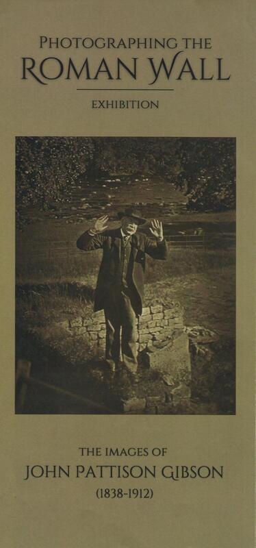
Thanks to the work of David & Margaret Blackett, the Knott Memorial Hall in Heddon has been successful in acquiring the 'Photographing the Roman Wall Exhibition’ touring as part of the Hadrian's Wall 1900 Festival.
This amazing collection of photographs were taken by Hexham Chemist, John Pattinson Gibson between 1886 and 1910. They were left in the care of Northumberland Archives. This year, Hadrian 1900 lottery funding has enabled a public exhibition. They have also been on display at Haltwhistle Town Hall and Hexham Abbey. They will be on display in the Knott Memorial Hall, Heddon on the Wall from 31st October until 18th November. Heddon Local History Society are hosting an introductory talk about the collection by Kate St Clair Gibson (Local Studies Librarian, Northumberland Archives) on Wednesday 9th November at 2pm in the Knott Hall.
Image dated c1955 - c1978 from Historic England
The shop was owned by the Gibson family, and was opened c1834, and closed c1978. J. P. Gibson, b.1838, became a notable photographer of archaeology, and helped to develop an artist style of photography in the late 19th century. The shop front and fittings were saved by the Science Museum in London, as the building was due for demolition, and are currently on display. 
Former Gibson Pharmacy, 16-18 Fore Street, Hexham. Photo A Curtis (2022)
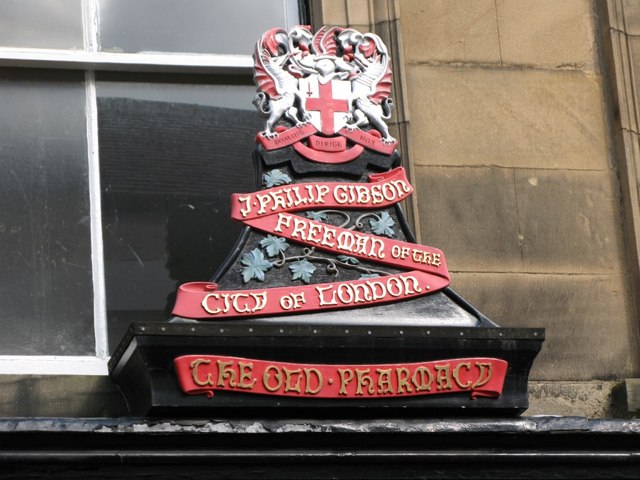
Wooden carving originally above Gibson's Pharmacy. © Copyright Mike Quinn (2007)
John Pattison Gibson was born in Hexham on 4th January 1838, the son of Clara and William Wilson Gibson, the local chemist.
He was educated at Hexham Grammar School and later Newcastle Grammar School after which he served his apprenticeship as a chemist. Gibson became interested in photography in about 1856 when he had his portrait taken by a school friend in Newcastle. Shortly afterwards he bought a set of apparatus himself for 30 shillings and set up a portrait studio above his father's shop. When he took over father's chemist business, however, he gave up portraiture in favour of landscape photography. He became renowned as a highly distinguished photographer, winning in excess of 50 medals locally and abroad, most notably the Paris International Exhibition of 1899. Gibson joined the Society of Antiquaries in 1883 and his interest in the Roman Wall grew. His first significant discovery was the Mucklebank Wall turret in 1891 which he happened upon thanks to a rabbit hole. He was involved in the excavation of the turret in 1892. 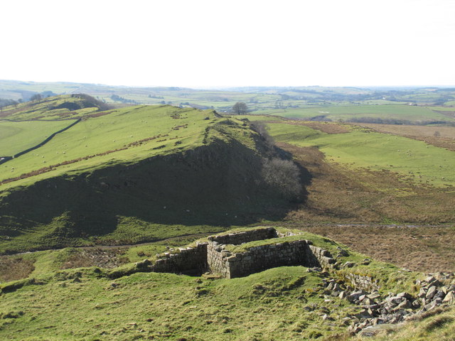
Turret 44b (Mucklebank) © Copyright Mike Quinn (2014)
He later assisted in the excavations at Great Chesters from 1894-6, all the while using his photographs of the findings to report back to the Society.
In 1907-8 he worked with Frank Gerald Simpson in excavating the small fort at Haltwhistle Burn and then once again in 1909, together with F.G. Simpson, he excavated Milecastle 48. The report was published the following year (see link below) and is one of the most important excavation reports published on a site on Hadrian's Wall. In 1911 he was made a Fellow of the Society of Antiquaries. 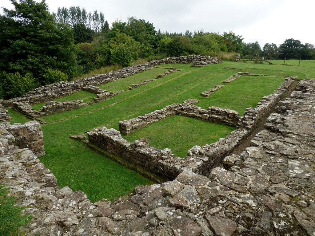
Milecastle 48 (Poltross Burn). © Copyright Sandy Gerrard (2021)
J. P. GIBSON, F.S.A., and F. GERALD SIMPSON (1911), The Milecastle on the Wall of Hadrian at the Poltross Burn. Transactions of the Cumberland & Westmorland Antiquarian & Archaeological Society 11 (series 2), p. 390 - 461.
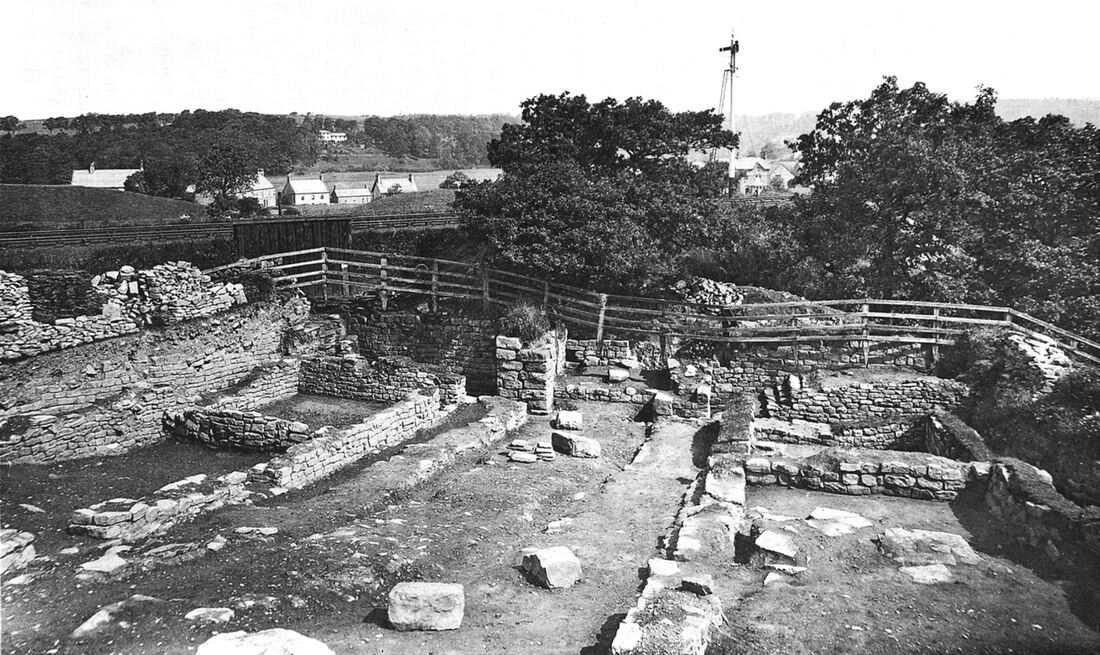
Fig. 1. General view, looking N.
Apart from his enthusiasm for archaeology and photography, Gibson was also a keen member of the local Volunteer Corps and retired as a Major in 1892.
John Pattison Gibson died in Hexham on 22 April 1912, aged 74.
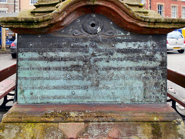
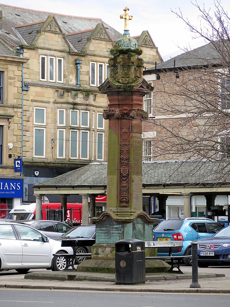
John Pattison Gibson had eight children, one of whom was the renowned Hexham poet, Wilfrid Wilson Gibson (1878-1962).
Black Land & White. © Copyright Andrew Curtis (2012).
Heather land and bent-land,
Black land and white, God bring me to Northumberland, The land of my delight. Land of singing waters, And winds from off the sea, God bring me to Northumberland, The land where I would be. Heather land and bent-land, And valleys rich with corn, God bring me to Northumberland, The land where I was born.
'Northumberland' by Wilfrid Wilson Gibson, Hexham's People's Poet.
Wilfrid's sister, Elizabeth Gibson, later Elizabeth Gibson Cheyne (1869-1931), was also a published author and poet.
LINKS
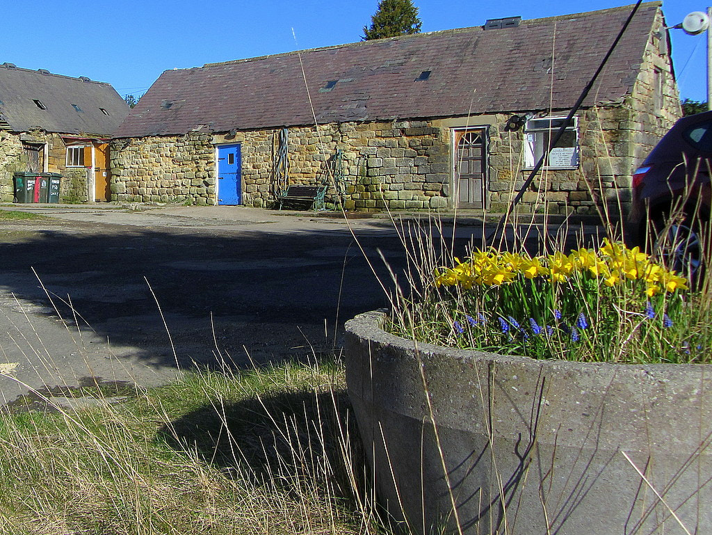
Town's former chemist's has pride of place in London's Science Museum. Hexham Courant 19th November 2019 Hexham Local History Society: Gibson Shop Gallery The village of Heddon on the Wall appears to have grown up around the location of the 12th Milecastle of Hadrian's Wall. The reasons quite why it did so, and the reasons a notable and early Saxon church (St Andrew's) was founded here are unknown (although see Ad Murum). Perhaps the rocky mound on which the church was built, standing south of Hadrian's Wall and the Vallum, was already the site of a Roman shrine. However, of this we have no evidence. Maybe the Saxon settlers who chose the spot for their village just liked the view as we do today. Milecastle 12 of Hadrian's Wall has never been definitively located although its measured location along the line of the Wall was considered to be within the enclosure west of Towne Gate. This was originally the site of Town Farm, later Tulip's Haulage Yard, and recently of the newly built development of houses known as Tulip Mews. Archaeological investigation of the Town Farm site during this development failed to locate remains of the Milecastle once the farm buildings had been demolished although did reveal limited remains of the curtain Wall itself. There are a few clues to the location of Milecastle 12:
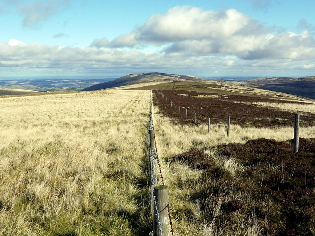
It is possible that the cottages refered to by Bates were those of Mushroom Row. Mushroom Row consisted of two rows of houses situated just north of the modern library, south of Chare Bank, which is a footpath which partly follows the ditch of the Vallum. After demolition of the houses in 1955 the site was used by the Amos Brother's Roman Wall Forge and is now the location of a large private house, Forge House. However, as Bates mentions a "hill-top now covered with the ruins of cottages", this, and its location south of the Vallum, seem to make Mushroom Row an unlikley candidate. The cottages he refers to are more likely to have been located in the enclosure that is now occupied by Tank House due west of the enclosure that held the buildings of Town Farm and the track which runs from the old road south towards Garden House. Tank House is located on the north side of Chare Bank. The house name refers to the stone-built water tank that stood on this hilltop site. It was the village water supply from the mid C19th, fed from springs rising near East Heddon. It went out of use when a metal tank on legs was provided further south, close to the library.  Heddon water tank building before building of the modern Tank House. Photo courtesy P Sanderson. The old plans and first edition Ordnance Survey map of Heddon on the Wall shown below show the presence of buildings within the enclosure surrounding Tank House. However, only one building remains there on the 25 inch to 1 mile map of 1897, clearly named, Tank House. Graeme Stobbs (Society of Antiquaries of Newcastle upon Tyne) came to the same conclusion in a short note published in 2019 from which the following figure has been taken: Stobbs, G. (2019). Note: The probable location of Milecastle 12, Heddon-on-the-Wall. Archaeologia Aeliana, 5th series, vol. 48, pp. 167-170. 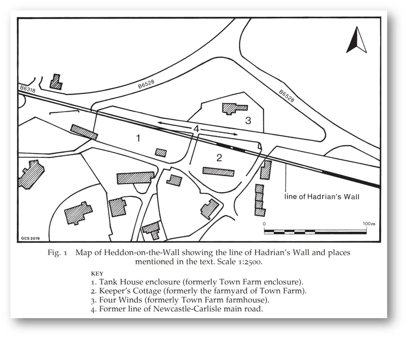 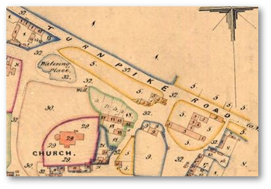 Tithe Award Map of Heddon (1848). Northumberland Archives, Ref. DT 229 M. 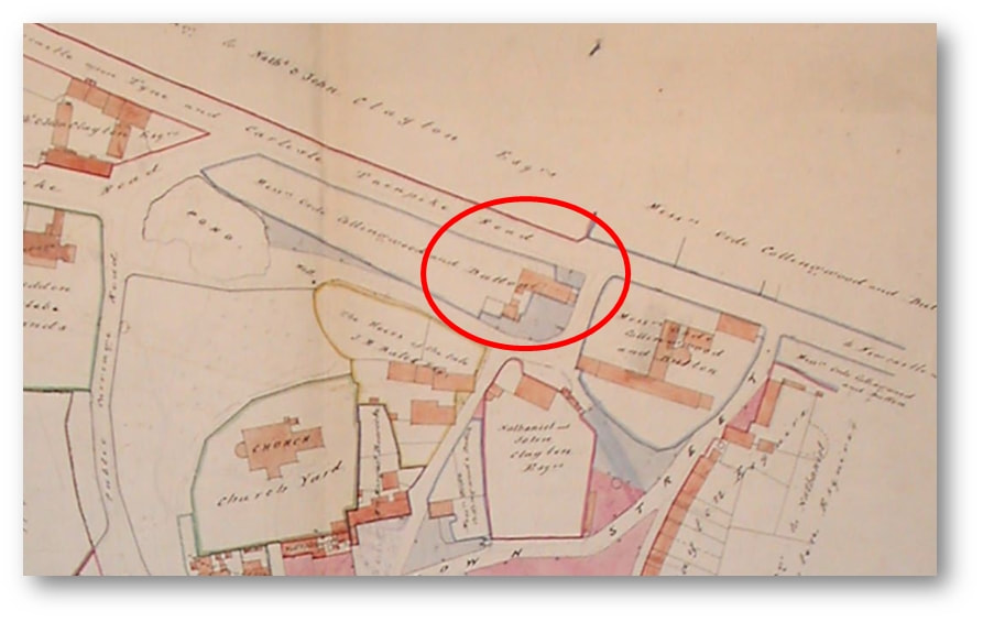 Plan of Heddon by Thomas Bell and sons (1856). Northumberland Archives, Ref. ZAN BELL 23–7. 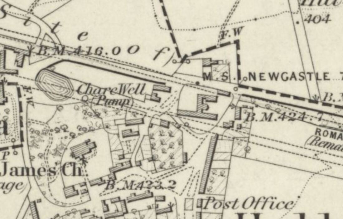 Ordnance Survey 6" to 1 mile, revised 1860, published 1865. National Library of Scotland. 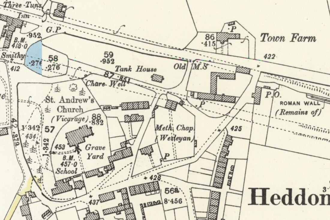 Ordnance Survey 25" to 1 mile, revised 1895, published 1897. National Library of Scotland. Plans show that Town Farm & the enclosure to its west (location of Tank House) were under the same ownership (numbered 5 on the Tithe Award Plan and named as ‘Messrs Orde, Collingwood and Dutton’ on Bell's Plan of 1856. Stobbs reasons that: The reason why Milecastle 12 was not located at the Town House farmyard in 1928 or in 2019, is that it actually sits some distance to the west, within the enclosure now known as Tank House Field (No. 1 on map). It might be objected that the eastern (Town Farm farmyard) possibility is one Roman mile from Milecastle 13, but it is well known that milecastles and turrets often lie slightly away from their measured positions for topographic reasons, and the higher ground of the Tank House enclosure may well have been preferred to the measured position. The site of the next milecastle to the east (11) is not established; measurement from its assumed position would place Milecastle 12 just to the west of the Town Farm site. Archaeological evaluation work within Tank House Field has been quite limited and there is probable potential that remains of Milecastle 12 may well survive within the enclosure, probably to the north-west of the current dwelling house. This should be considered more likely to be the milecastle site than the Town Farm location. 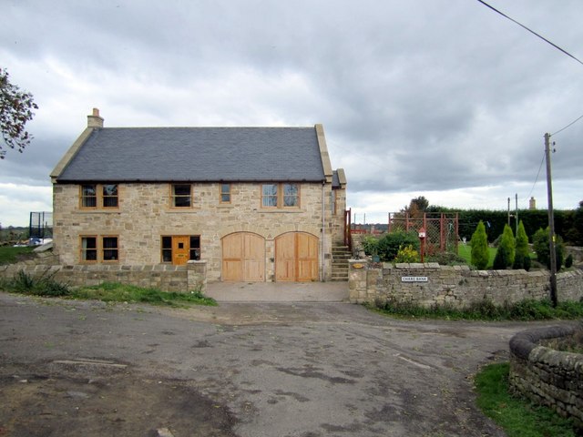 Tank House. View from the front of the house above Chare Bank. Photo A Curtis (2010). 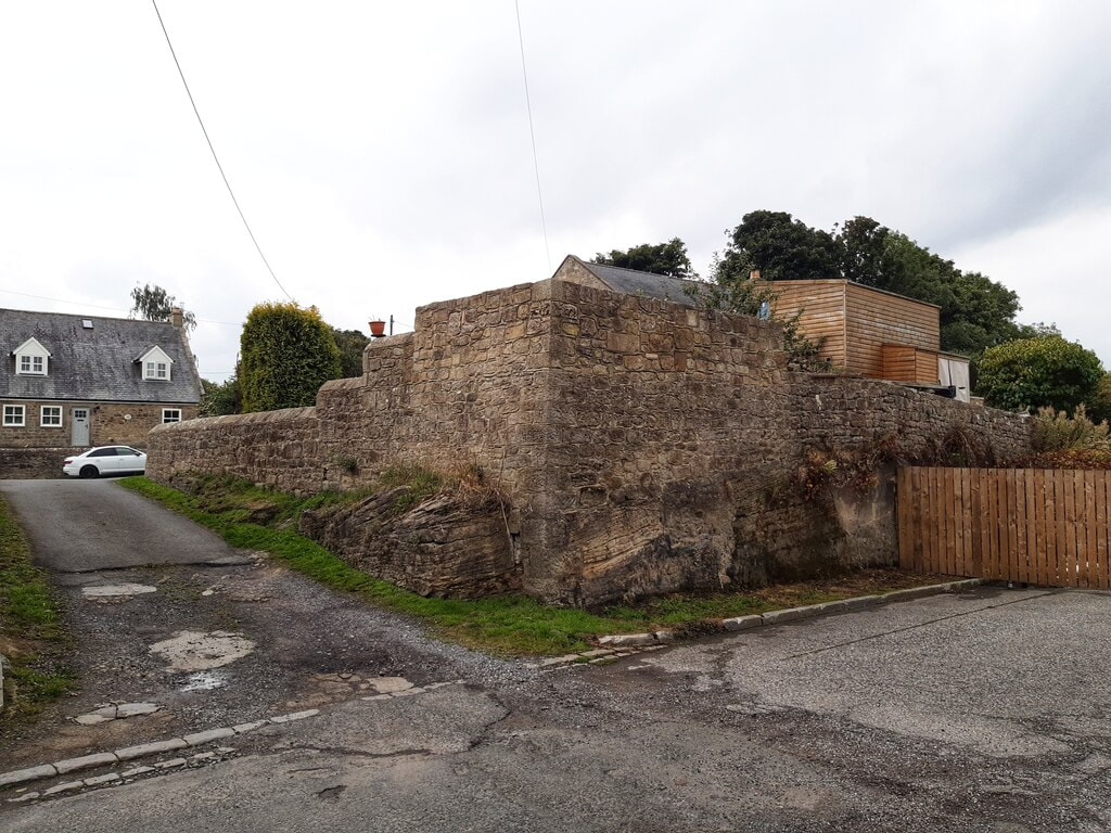 Rear wall of the back garden of Tank House above the (former) Military Road. Photo A Curtis (2022). In the photo shown above, the old road runs in the foreground of the above photo from left to right. This was the line of the Military Road (constructed in the 1750s, mainly on the foundations of Hadrian's Wall) and later the course of the A69 from Newcastle to Carlisle. The road closed when the bypass was built. The line of the Wall here lies just south of the road (the Wall perhaps had already been flattened by building within the village). The track on the left also cuts through bed-rock, runs up towards the rear of Garden House, and divides the enclosures of the original Town Farm and Tank House. This location is close to the suspected site of Milecastle 12, although it has never been found. Recent archaeology has shown it wasn't in its measured position under the buildings of Town Farm (later Tulip's Haulage Yard) slightly further east. The road was widened in 1926. At the same time, or perhaps earlier, it was cut deep into sandstone bedrock (visible below the wall) to remove an unnecessary hill. As the milecastle wasn't revealed on the line of Hadrian's Wall further east there is a high possibility that it is located somewhere on the hill in the garden above the wall, the back garden of Tank House. There were old buildings here above the road, indicated on old plans, and it might of course have been completely destroyed. 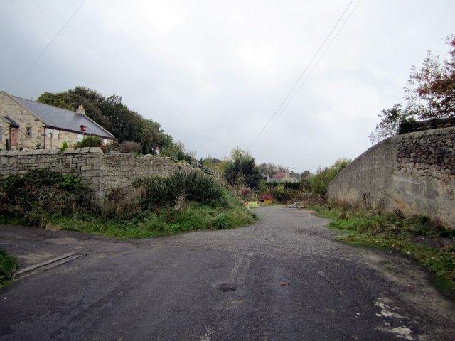 Old road near at the rear of Tank House. Photo A Curtis (2010). UPDATE January 2023 Matthew Hobson (2021) proposes a more westerly location of MC12 "somewhere between the western boundary of the current development site and the Shell garage to the west that faces onto Hexham Road. Use of Ground Penetrating Radar could perhaps be used successfully to solve this long-standing question." An archaeological watching brief at Heddon-on-the-Wall and the probable location of Milecastle 12 by Matthew S. Hobson. Archaeologia Aeliana, 5th series, vol. 50 (2021), pp. 115–132. Two phases of trenched archaeological evaluation and a watching brief were conducted by Wardell-Armstrong LLP on two nearby plots of land, formerly belonging to Town Farm, and bisected by the projected line of Hadrian’s Wall at Heddon-on-the-Wall, Northumberland. The works were deserving of particular scrutiny because the measured location of Milecastle 12, one Roman mile east of the known location of Milecastle 13, falls squarely within the development area. Indeed, a discovery of a pivot stone, probably the northern gate of the milecastle, was recorded close to the west end of an outbuilding of Town Farm in 1926. A number of later investigations at Town Farm have recorded a high degree of truncation on the site and failed to locate traces of either the milecastle or of Hadrian’s Wall. This has led to the commonly held belief that the remains of the milecastle were probably destroyed during the construction of farm buildings, or indeed earlier. The comprehensive redevelopment of the site, however, has allowed the collection of sufficient data to revisit this issue once again. Two surviving sections of the Broad Wall were recorded during the watching brief over a 20-metre stretch, proving that later truncation had not removed the entirety of the Roman archaeology on this site. The southern edge of the Wall Ditch and its upper fills were observed in the north-east of the development area and in evaluation trenches excavated along the lane to the north. The only datable finds came from a medieval kiln of unknown function, situated between Hadrian’s Wall and the Wall Ditch. The kiln is similar in form to the one still visible at the western end of the extant stretch of the Wall, 70 metres to the east. This new discovery indicates that there may have been a group of such features in this area in use from approximately the mid-13th to mid-15th century AD. With the exception of the easternmost section of the Broad Wall and the medieval kiln, all of the archaeological discoveries were made within the area of the Scheduled Monument. Each of the significant archaeological deposits, including a buried land surface preserved beneath the Wall, was sampled, but no significant archaeobotanical results were obtained. While no traces of Milecastle 12 were found, the work has led to the realisation that the discovery of 1926 was very probably made farther to the west than originally thought, where the now more accurately projected line of Hadrian’s Wall meets the former Carlisle to Newcastle main road. 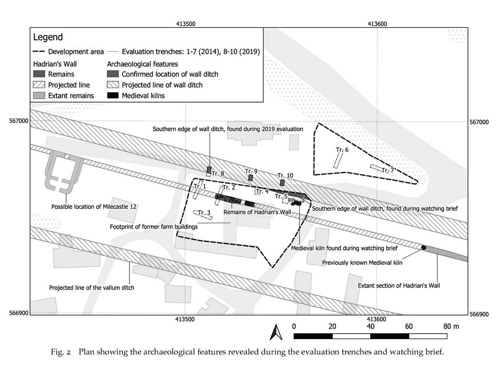 DISCUSSION: THE PROBABLE LOCATION OF MILECASTLE 12 As noted above, the measured location of Milecastle 12 falls within the development area, more or less precisely at the north-west corner of the former farm buildings. The identification of preserved remains of Hadrian’s Wall at this location, in an area which had previously been assumed to have suffered complete truncation, warrants a reassessment of the probable location of this milecastle. The 2019 investigations have confirmed that the line of the Broad Wall was positioned rather too far south to have been disturbed by the widening of the old Carlisle to Newcastle road in 1926 (referred to above). If the pivot stone discovered during the 1926 roadworks was indeed part of the in situ northern gate of Milecastle 12, the clear implication is that its location is likely to have been farther west, close to where the projected line of the curtain wall meets the remains of the old road. In our estimation the discovery of the pivot stone in 1926 is most likely to havebeen some 90m farther to the west than the measured location of the milecastle, as indicated on fig. 2. Supporting the idea that the discovery in 1926 was made farther to the west, is the fact that in 1856 the development area and the neighbouring plot of land to the west were both in possession of Messrs. Ord, Collingwood and Dutton. Stobbs (2020) has correctly observed that if these two plots of land could both be referred to as Town Farm, it would make sense of the fact that the pivot stone was described as having been found ‘close to the western end of an outbuilding of Town Farm’. The idea that the measured location of Milecastle 12 might have fallen west of the current development area, which he also refers to, cannot however be supported. The salient fact, which Stobbs does also note, is that the distance between the so called ‘milecastles’ varied depending upon the terrain and the need to communicate with forts on the Stanegate (Breeze 2006, 64–65). A discrepancy of 90m, between a measured hypothetical mile separating two adjacent milecastles and the actual distance, would be slightly more than the known average, but significantly less than the largest recorded discrepancy of more than 210m. The high level of truncation within the current development area leaves us with a high degree of uncertainty. It is still possible that the pivot stone was found during work linking up the east-west road with the north-south lane which separates these two plots of land. If any remains of the milecastle lay within the western half of the development area they are very likely to have been destroyed. The remaining uncertainty means that in future the location of the milecastle should be sought somewhere between the western boundary of the current development site and the Shell garage to the west that faces onto Hexham Road. Use of Ground Penetrating Radar could perhaps be used successfully to solve this long-standing question.
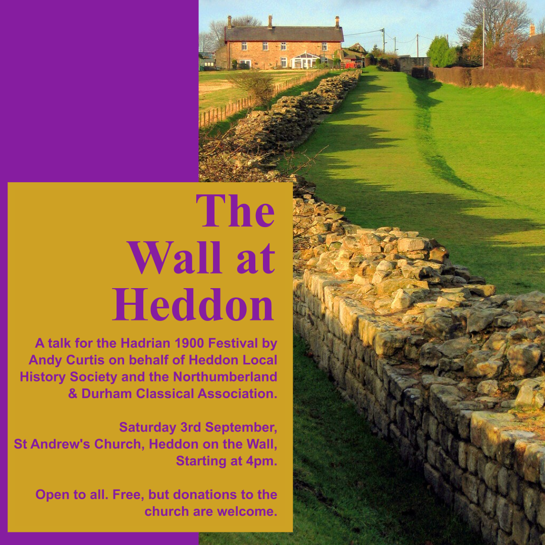
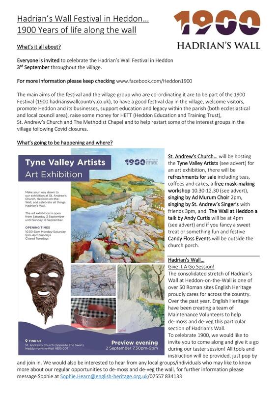
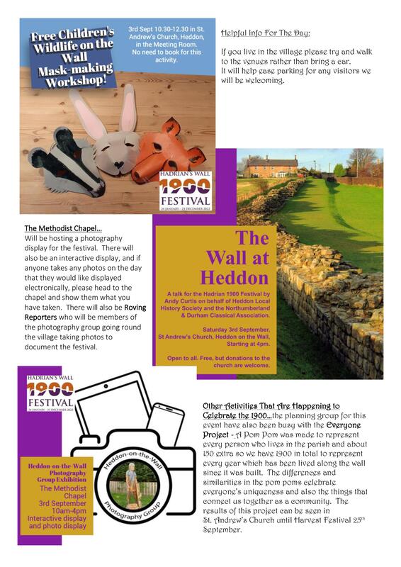
Many events at several venues around the village on Saturday 3rd September 2022.
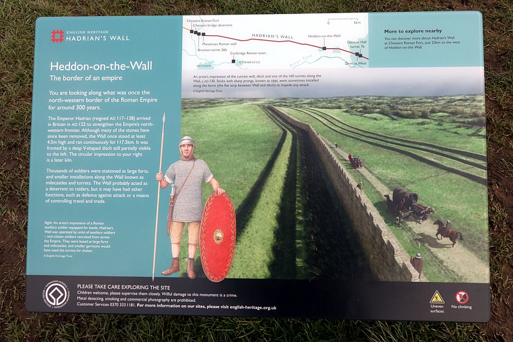
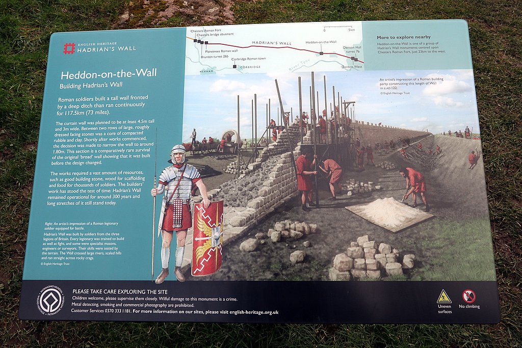
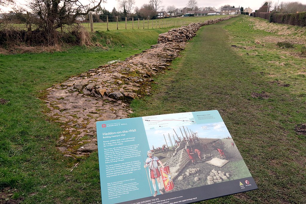
 English Heritage has recently renewed their interpretation boards for the restored section of hadrian's Wall on the east side of Heddon village. The two boards at each end of our section of the Wall feature reconstruction artworks by Peter Lorimer.
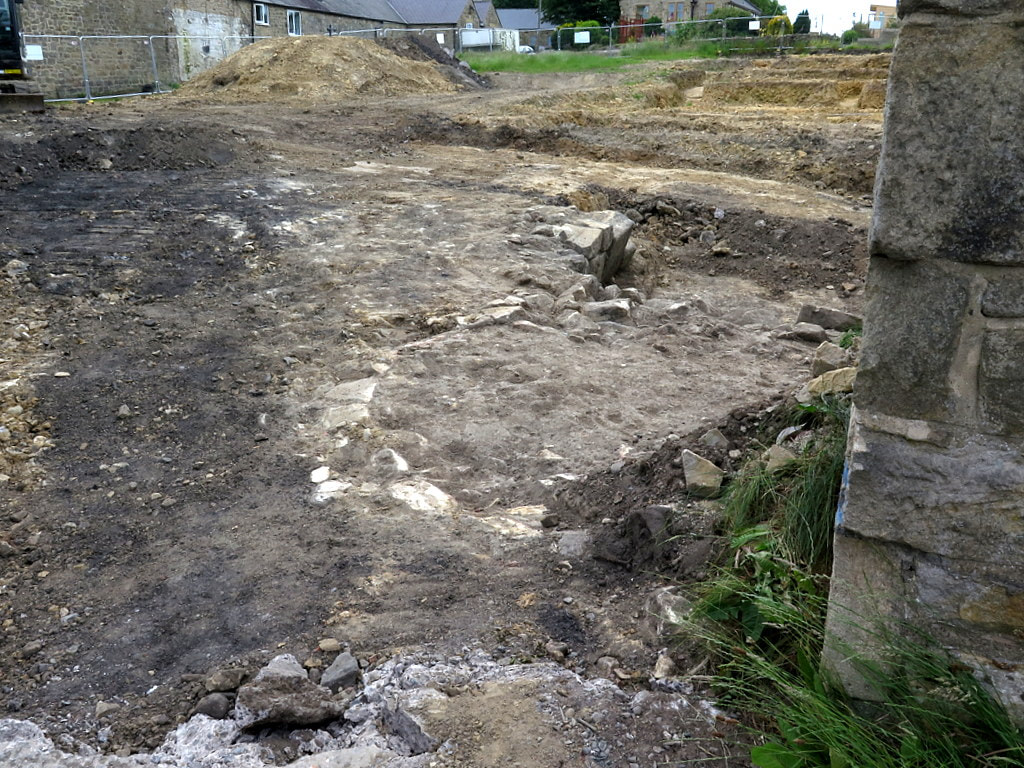
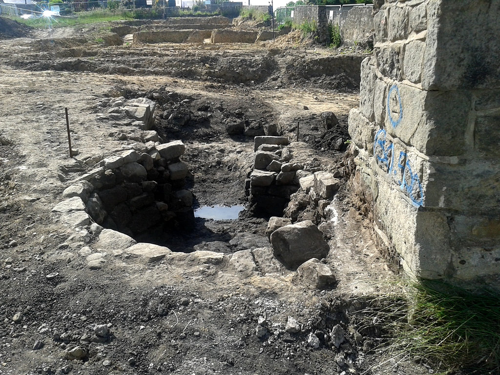
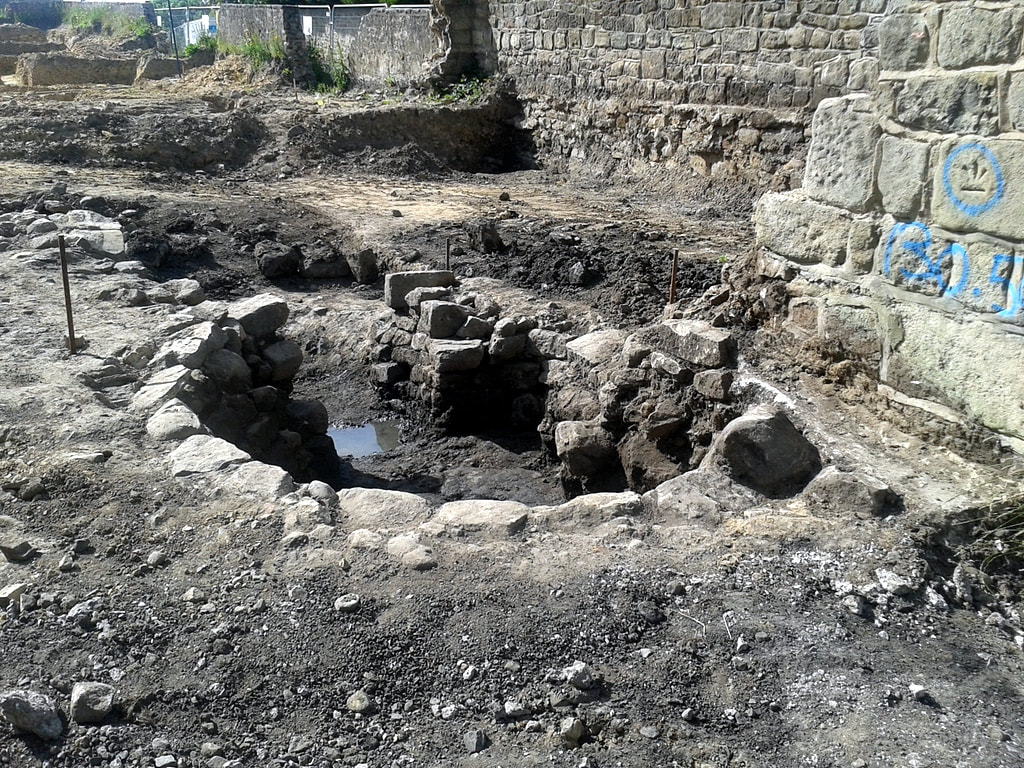
Following the excitement with the find of a section of Hadrians Wall on the Town Farm development site we now report on a new archaeology find, close to the eastern entrance. We must await the full archaeology report but it is clearly a medieval or post-medieval corn-drying kiln, very simillar to that built into the conserved section of Hadrian's Wall, slightly further east, across Towne Gate. The excavation was undertaken by an archaeologist from Wardell Armstrong, and my photos taken, with careful regard for health & safety, through the wire fence at the east entrance to the building site. The location of the kiln is likley to lie close to, but just to the north of the line of Hadrian's Wall, which hadn't been visible in this area of the site. Behind the circular part of the kiln in the foreground is a deep fire-pit bounded by large masonry on the south side. LINK
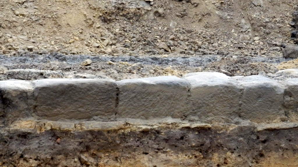
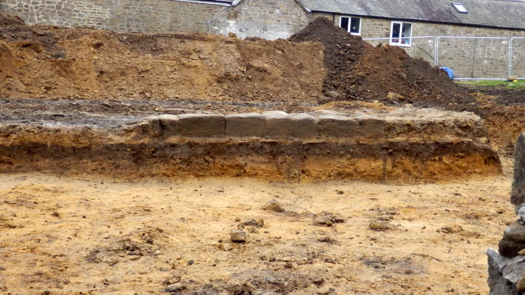
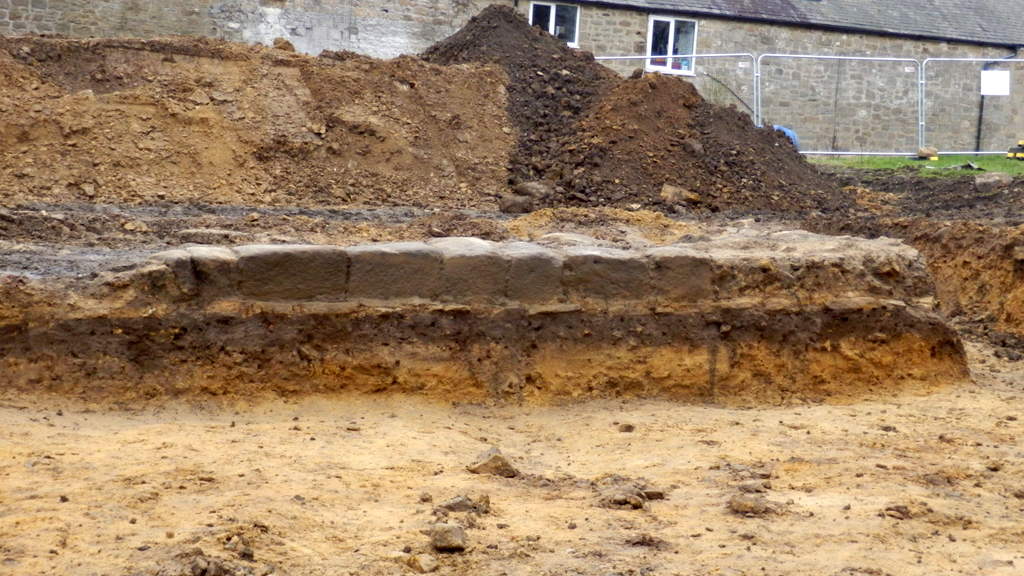
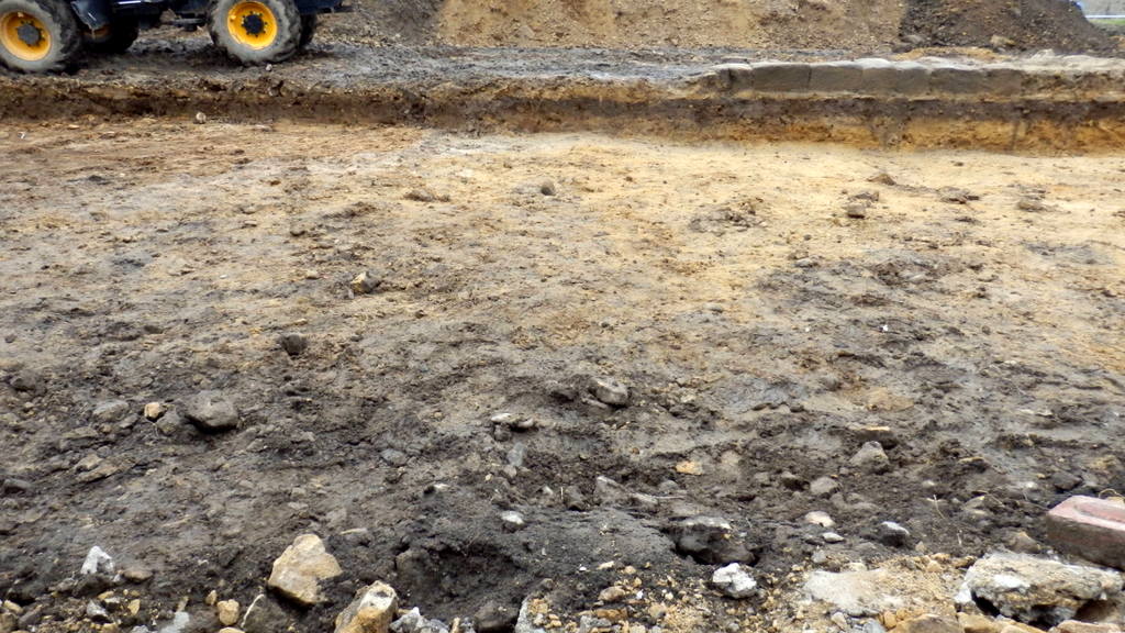
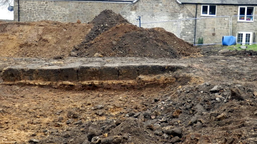
Wardell Armstrong - Tulip Mews, Heddon-on-the-Wall, Northumberland. Watching Brief Report (2020). 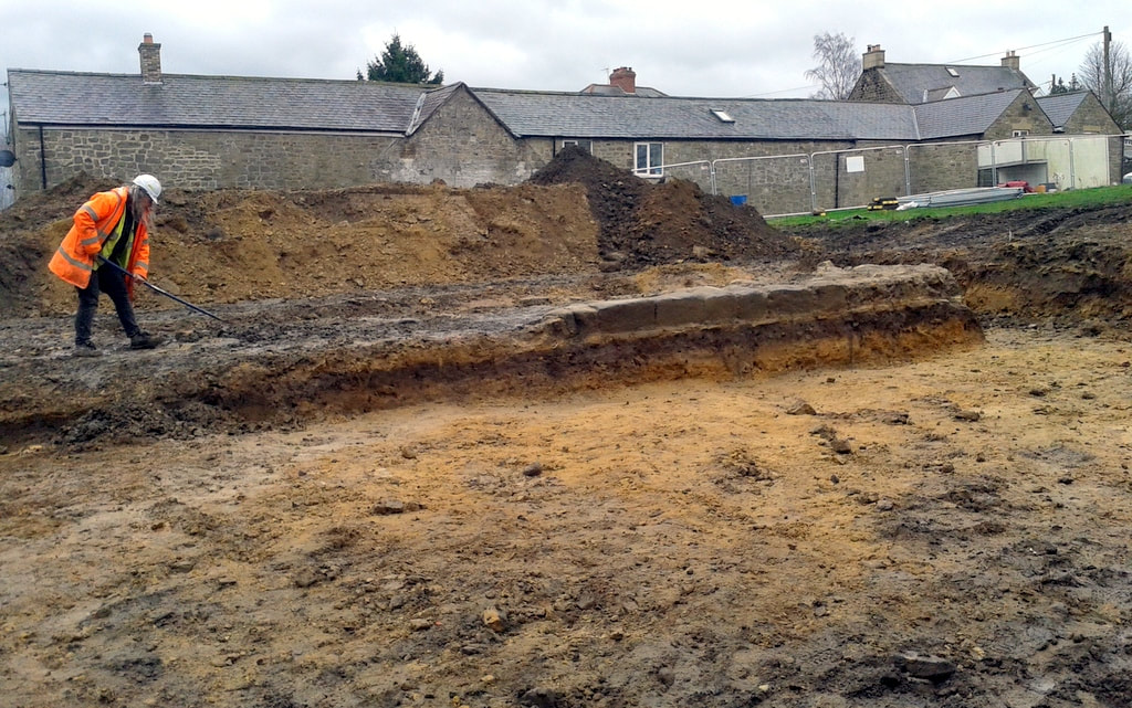 Archaeologist clears soil from eastern section of the rubble core of uncovered section of Hadrian's Wall. Facing stones of the lower course only found on the N side, to the right of the photo. A Curtis (2019). 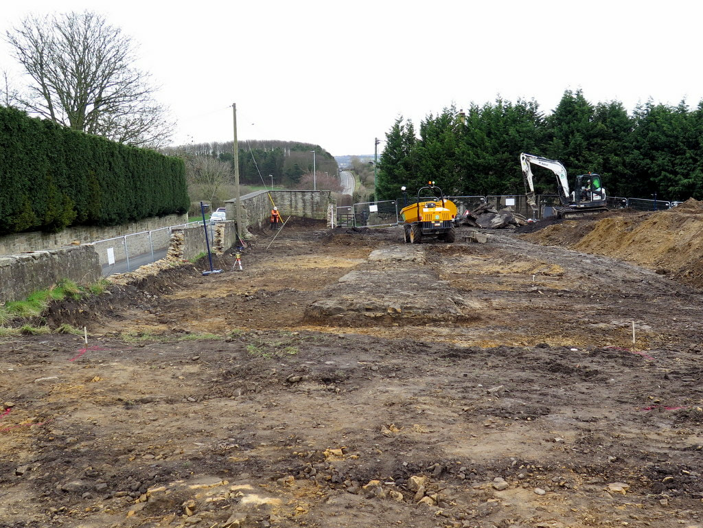 View E along line of newly uncovered section of Hadrian's Wall. In the distance is Hexham Road climbing over Great Hill on the way to Throckley. The conserved section of the Wall is located to the right of the road. Photo A Curtis (2019). 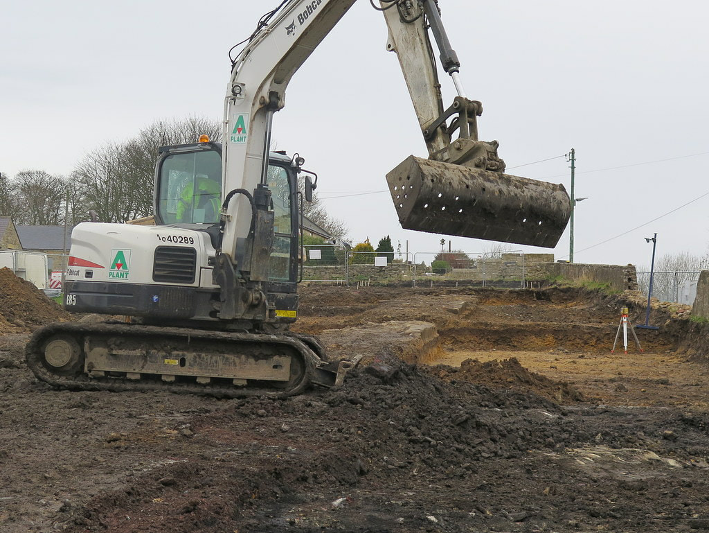 Below and just beyond the digger lies the newly uncovered section of Hadrian's Wall viewed to the W. Tank House can be seen behind the digger cab. Only the lower course of facing stones remain on the N side of the Wall, set in clay on a flagged base. Photo A Curtis (2019). Photos below, taken in June 2017, are of the old Town Farm (Tulip's Yard) before demolition of the old buildings. Photos below of the revealed section of Hadrian's Wall taken by Bill Pointer 8th March 2019. 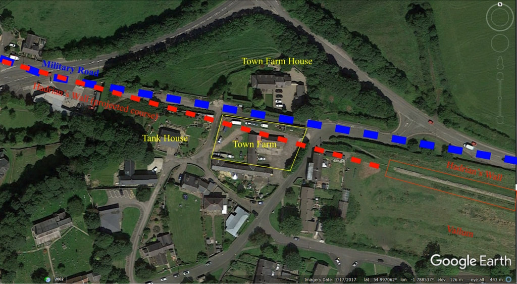 Location aerial view. Google Earth (2019). Those who have followed developments of the former site of Town Farm, later Tulip’s Haulage Yard, on the East side of the village will have seen in the past weeks, the old, derelict buildings of the farmstead demolished, a new section of Hadrian’s Wall briefly found and cleared, and the site prepared for the building of five new bungalows. I don’t know much about the early history of Town Farm but have speculated that it was in place in 1750 requiring the slight adjustment of General Wade’s Military Road from using the line (and foundations) of Hadrian’s Wall, west from Great Hill. This led to the preserved section of the Wall otherwise largely destroyed and covered by the road. This road, the first properly constructed road in Northumberland since Roman times, became the Newcastle to Carlisle Turnpike and later the A69, before it was abandoned and the bypass constructed. Beside the old road, below the retaining wall of the Town Farm site, still stands a milestone recording a distance of 7 miles from Newcastle’s West gate. It is probably one of the original milestones of the turnpike road from around 1780. The original farm may have adjoined the old buildings, incorporating both farmhouse and barn as one long building. The two-storey farmhouse still standing on the north side of the old road, previously Four Winds and now Glanville House, was probably a much later addition. At one time, like much of the village, it was owned by the Clayton family. The farmer in 1901 was William Stephenson who lived in the farmhouse with his wife Sarah and six children. William had been born at Rudchester and was nephew of William Stephenson who founded Throckley Brick Works and whose son, Sir William Haswell Stephenson of the Throckley Coal Company was seven times Lord Mayor of Newcastle. In 1901 a gamekeeper, George Charlton, lived in what is now Keepers Cottage. He died in 1931 and has a gravestone in St Andrew’s churchyard erected by Brigadier General Sir Loftus Bates of Heddon Hall ‘in memory of an old friend’. There was a large fire at Town Farm in 1913 which destroyed buildings and livestock. It was fought by local people until the fire brigade arrived from Newburn, alerted by a youth on a bicycle. In 1918 it was bought for £3000, along with many of the other village properties, by Sir James Knott who had a vision of turning Heddon into a model village. However, after the events of the First War and loss of his two sons, his interest in the village came to an end. Town Farm was Lot 1 in his sale of 1924. Town Farm, on the site of the Roman Wall, including 38 acres of old grass land, was sold to Adam and James Hedley for £2800. They were already faming Bays Leap, bought from the Claytons in 1918. James Knott retained the small field containing the currently preserved section of Hadrian’s Wall which he later instructed to be gifted to the Society of Antiquaries of Newcastle upon Tyne. Around 1927, Town Farm was rented from the Hedleys by William Ward Sanderson. He lived in the farmhouse and farmed the fields on the east side of the village, milking cows in a parlour at the farmstead, cutting hay on the site of the Roman Wall and running a local shop selling cigarettes and confectionary. The end of farming came when the land was sold for the building of the Vallum housing estate in the 1950s. The farm buildings became part of Tulip’s Yard, base for a successful haulage company. The wall of the farm next to the old road sported adverts for the local shop and a Heddon on the Wall road-sign on a photo of army cadets resting on the grass below taken around 1950. Part of this photo was used on the album of The Eton Rifles by The Jam in 1979. Demolition of the farm buildings in the past weeks and thorough archaeological excavation of the site has revealed the continuation of Hadrian’s Wall in two runs of large stones marking the lower course of its north face, and rubble core set in clay remaining below the old buildings. Most of the stones had been previously robbed and presumably reused elsewhere, perhaps including the church and even the buildings of Town Farm. Milecastle 12, known by measurement to be in this vicinity, hasn’t yet been found and may have been further west, perhaps under the garden north of Tank House. Similar remains of the Wall are known to exist below the tarmac of General Wade's road something that causes all sorts of problems for utility companies wanting to dig holes. Cadwallader Bates in his History of Heddon published 1886: This mile-castle probably stood to the east of the pond, on the hill-top now covered with ruins of cottages. The Rev. G. Bowlker, vicar of Heddon, has heard that the people who lived in these cottages, in digging a hole in front of them for burying a horse, came on old foundations and what they described as a grave-stone with letters on it. This they promptly broke up. Nothing has been agreed to date but interest has been expressed in the village obtaining at least some of the Hadrian’s Wall stones if they are not wanted elsewhere, perhaps to enhance the area around the Victrix sculpture, letting us put the centurion close to a little part of the fabric of the original Roman Wall. 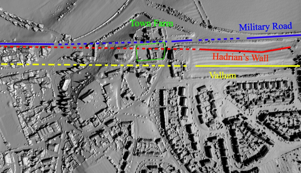 1m LIDAR 3D. houseprices.io lab (2019). Map rendering provided by houseprices.io free to use under Creative Commons Attribution Licence CC BY 4.0 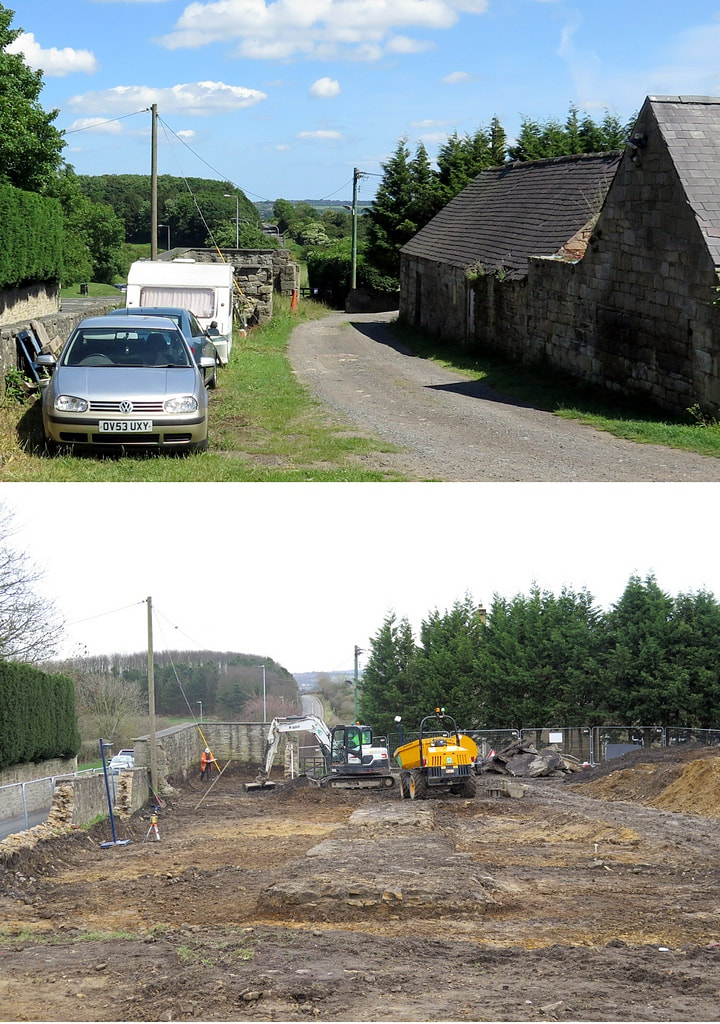 Before & after. Photos A Curtis. The sections below are taken from: Wardell Armstrong - Tulip Mews, Heddon-on-the-Wall, Northumberland. Watching Brief Report (2020). The remains of Hadrian’s Wall identified at the site measured c.20 min length and comprised facing stones laid on a foundation of flat sandstone slabs, with a core of irregular sized sandstone fragments set in puddled clay. The Wall survived to a maximum height of 0.45m and was 2.9m at its widest surviving point. The width of the surviving remains is consistent with the Broad Wall sections of the monument, which was originally designed to be 2.9m wide (Symonds & Mason 2009, 38; Table2). It is also consistent with the surviving extant section of the Wall located to the east of the site (NHLE 1010616) which measures between 2.8m and 3m in width. In addition to remains associated with Hadrian’s Wall, the watching brief also identified a well preserved stone‐lined kiln with associated firepit and flue. The kiln was initially considered to be associated with the Roman activity at the site, but the recovery of several sherds of medieval pottery from the feature (the only medieval pottery recovered anywhere during the watching brief) and its location on the northern side of the Wall has highlighted that it relates to a later phase of activity, probably the 14th or 15th century. Apart from the recovery of oak charcoal, primarily from the firepit, no indication of use of the kiln was identified, although it is possible that the feature was used as a corn drying kiln similar to the medieval kiln built into the extant section of the Wall immediately to the east of the site. LINKS
The Wall at Heddon Heddon History - Hadrian's Wall Hadrian's Wall on Tyneside (pdf) Hexham Courant - 19th March 2019 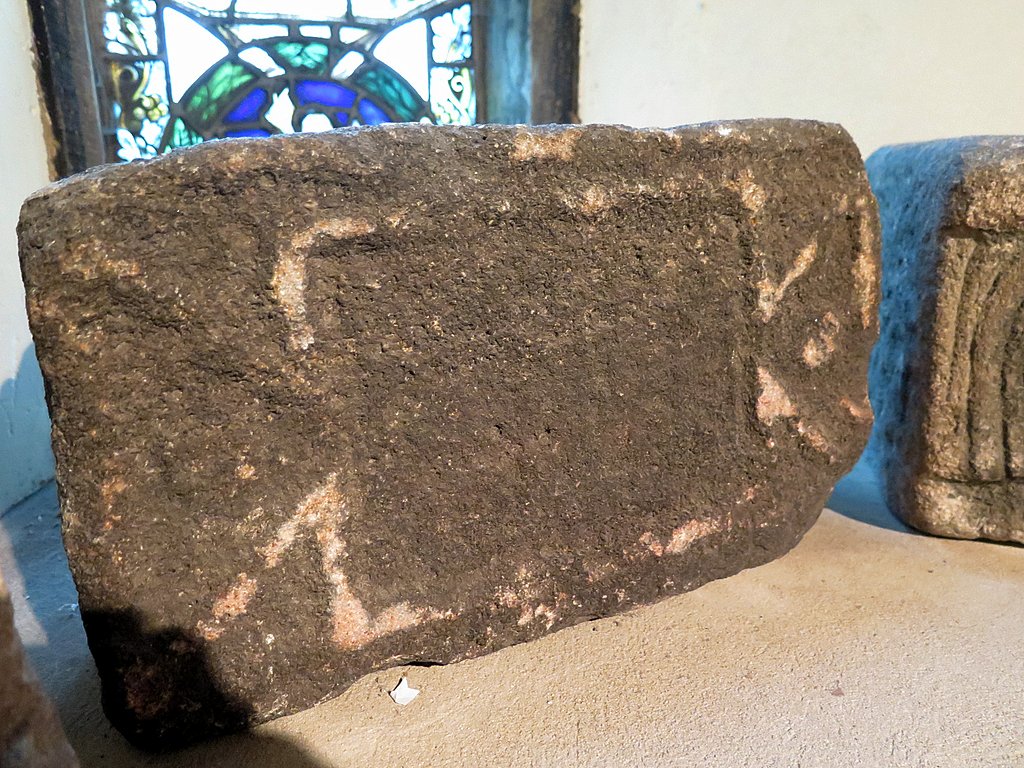 Roman 'centurial' stone, St Andrew's Church, Heddon. Photo A Curtis (2018). Having taken part in the pilot study of the Hadrian's Wall Stone Sourcing & Dispersal Project I thought I would try to find out a little more about the Roman stone shown above.
Along with two other carved stones (probably not Roman), it sits on the inside window-ledge of the window at the west end of the north aisle, inside the little meetings room divided by glass panels from the bulk of the church. It appears not to have an inscription but its size and moulding bears much resemblance to other stones found along Hadrian's Wall which record the particular centurial unit involved with building or maintaining a specific length of the Wall's fabric. 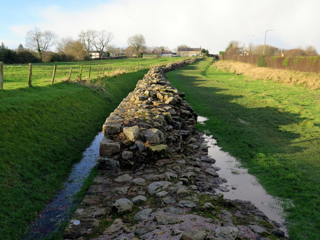 Hadrian's Wall east of Heddon on the Wall. Photo A Curtis (2015). Below is the official briefing document for the pilot study of a new proposed Hadrian's Wall Community Archaeology Project taking place in Heddon on the Wall over three days in March and April 2018. The project is organised and supported by archaeologists at the University of Newcastle upon Tyne. The Stone Sourcing and Dispersal project (SS&D, also known as Where’s Hadrian’s Wall Gone?) is part of a proposed three year project, the Hadrian’s Wall Community Archaeology Project, which in parallel with the SS&D will be working with community groups to investigate a significant number of areas along the entire length of the Wall that are currently classified as Heritage at Risk. Work will also be carried out to take action, working with the community, to ameliorate the risks to the Wall.
|
AuthorAndy Curtis Archives
July 2024
Categories
All
|
||||||
- Home
- Calendar
- Introduction
- Where are we?
- History Map
- Timeline
-
Heddon's History
- Prehistory
- Hadrian's Wall >
-
Six townships
>
-
1 Heddon township
>
- Heddon in the Middle Ages
- Common Land
- Middle Marches
- Tithe Award
- St Andrew's Church >
- Village property
- Heddon Hall >
- Heddon Banks Farm
- Frenchman's Row
- Methodist Church >
- Men's Institute
- Women's Institute
- Welfare Field
- Knott Memorial Hall
- Memorial Park
- Schools
- River Tyne
- Coal Mining
- Quarrying
- Water Supplies
- Transport
- Waggonway & Railway
- Occupations from 1800
- Miscellaneous
- 2 West Heddon township
- 3 East Heddon township
- 4 Houghton & Close House township >
- 5 Eachwick township
- 6 Whitchester township
-
1 Heddon township
>
- Rudchester
- People
- Old Photos
-
Old News
- Community News
- Letter from the Emigrant Clergy of Frenchman's Row (1802)
- Alleged Brutal Murder at Heddon-on-the-Wall (1876)
- Sad boat accident at Ryton (1877)
- Coronation tree (1902)
- 65 Years on a Ferry Boat (1929)
- Come claim your kiss at Heddon (1953)
- The Swan (1972)
- Heddon WI (1987)
- Church House (1966)
- Happy return (1993)
- Hexham Courant (1997)
- Butterfly Garden (1999)
- Foot & Mouth (2001)
- Remembrance Day (1996)
- Remembrance Day (2016)
- RAF at Ouston (2007)
- Close House Golf Course (2009)
- Heddon pupils celebrate British heritage (2011)
- Roman Wall Forge (2011)
- Diamond Jubilee (2012)
- Auction of Bronze Statue, Close House (2012)
- Heddon WI (2012)
- Puffing Billy Festival (2013)
- Heddon Village Show (2014)
- View of the North (2014)
- The Wall at Heddon (2014)
- Heddon Village Show (2015)
- War veterans singing send-off (September 2015)
- Anglo-Saxon history (2014)
- Heddon WI at 100 (2017)
- Hadrian's Wall discovery (2019)
- Tulip Mews (2020)
- Mike Furlonger
- Hadrian's Wall 1900 Festival
- Memories
-
Other documents
- Mackenzie (1825)
- Bates (1886) >
- History, Topography & Directory of Northumberland (Bulmer's) - 1886
- History of Northumberland (1930)
- Collingwood Bruce (1853)
- Whellan (1855)
- Post Office Directory (1879)
- Prominent people in Heddon
- Place names
- Ad Murum
- Archived documents
- Thomas Bewick's History of British Birds (1826)
- Census data 1801-1991
- Historical Records 1888-1890
- Knott Sale of Village Property (1924)
- Extracts from Parish Council Records
- Local colliery records
- Blackburn (1938)
- Clark (c.1963)
- History of Church (1968)
- Boundary Commission Report 1984
- Village Atlas 2022
- Walks
- Blog
- Contact us
- Links
- What's new
- Site search
- Past & Present
- Photo of the Month
- Place Name Studies
- Heddon from Above


 RSS Feed
