
The village of Heddon on the Wall appears to have grown up around the location of the 12th Milecastle of Hadrian's Wall. The reasons quite why it did so, and the reasons a notable and early Saxon church (St Andrew's) was founded here are unknown (although see Ad Murum).
Perhaps the rocky mound on which the church was built, standing south of Hadrian's Wall and the Vallum, was already the site of a Roman shrine. However, of this we have no evidence. Maybe the Saxon settlers who chose the spot for their village just liked the view as we do today.
Milecastle 12 of Hadrian's Wall has never been definitively located although its measured location along the line of the Wall was considered to be within the enclosure west of Towne Gate. This was originally the site of Town Farm, later Tulip's Haulage Yard, and recently of the newly built development of houses known as Tulip Mews.
Archaeological investigation of the Town Farm site during this development failed to locate remains of the Milecastle once the farm buildings had been demolished although did reveal limited remains of the curtain Wall itself.
There are a few clues to the location of Milecastle 12:
- MacLauchlan (1858) failed to mark the milecastle on his survey, suggesting that he could not see it.
- Cadwallader Bates in his history of Heddon on the Wall (1886) states in footnote 3: "This milecastle probably stood to the east of the pond, on the hill-top now covered with ruins of cottages. The Rev. G. Bowlker, vicar of Heddon, has heard that the people who lived in these cottages, in digging a hole in front of them for burying a horse, came on old foundations and what they described as a grave-stone with letters on it. This they promptly broke up. Can it have been an inscription recording the names of Hadrian and his legate Platorius Nepos, like those found in the mile-castles at Castle-Nick, Milking Gap, &c?"
- In 1926, J. A. Bean (County Engineer to Northumberland County Council) said, ‘The road contractor had noted a large stone with a pivot hole therein at a point on the north side of Heddon Town Farm enclosure, on the south side of the main road, during the road widening in 1926’.
- This discovery of what sounds like a pivot stone from the north gate of a milecastle was recorded in Archaeologia Aeliana in the following year: ‘The gateway of this milecastle was found in making alterations to the road in 1926, close to the west end of an out-building of Town Farm.’ (Brewis 1927, 121, n.19).
- Recent archaeological investigation for the development of new houses at Tulip Mews, after demolition of the old farm buildings of Town Farm, located the remains of Hadrian's Wall but revealed no sign of the milecastle.
It is possible that the cottages refered to by Bates were those of Mushroom Row.
Mushroom Row consisted of two rows of houses situated just north of the modern library, south of Chare Bank, which is a footpath which partly follows the ditch of the Vallum. After demolition of the houses in 1955 the site was used by the Amos Brother's Roman Wall Forge and is now the location of a large private house, Forge House.
However, as Bates mentions a "hill-top now covered with the ruins of cottages", this, and its location south of the Vallum, seem to make Mushroom Row an unlikley candidate.
The cottages he refers to are more likely to have been located in the enclosure that is now occupied by Tank House due west of the enclosure that held the buildings of Town Farm and the track which runs from the old road south towards Garden House.
Tank House is located on the north side of Chare Bank. The house name refers to the stone-built water tank that stood on this hilltop site. It was the village water supply from the mid C19th, fed from springs rising near East Heddon. It went out of use when a metal tank on legs was provided further south, close to the library.
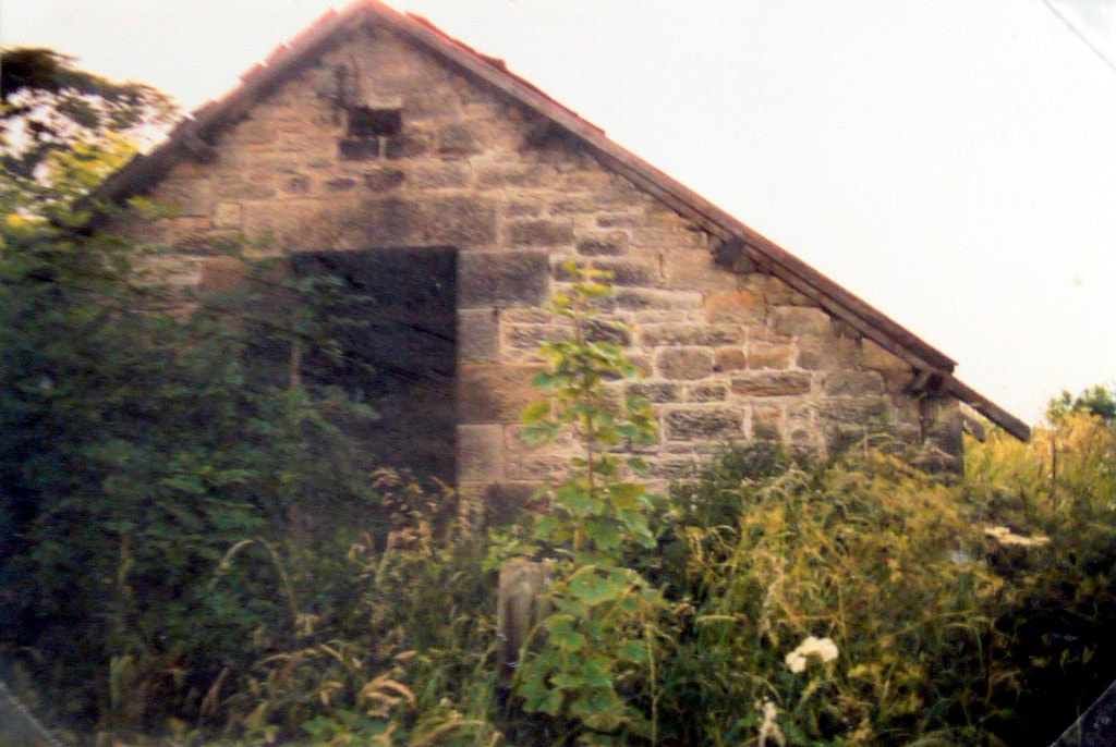
Heddon water tank building before building of the modern Tank House. Photo courtesy P Sanderson.
The old plans and first edition Ordnance Survey map of Heddon on the Wall shown below show the presence of buildings within the enclosure surrounding Tank House. However, only one building remains there on the 25 inch to 1 mile map of 1897, clearly named, Tank House.
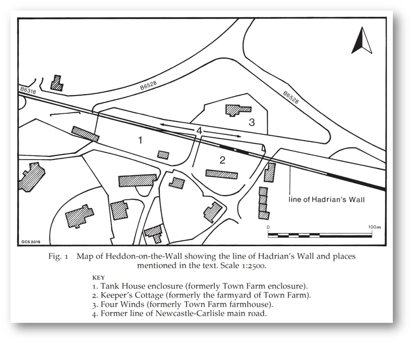
Graeme Stobbs (Society of Antiquaries of Newcastle upon Tyne) came to the same conclusion in a short note published in 2019 from which the following figure has been taken:
Graeme Stobbs (Society of Antiquaries of Newcastle upon Tyne) came to the same conclusion in a short note published in 2019 from which the following figure has been taken:
Stobbs, G. (2019). Note: The probable location of Milecastle 12, Heddon-on-the-Wall. Archaeologia Aeliana, 5th series, vol. 48, pp. 167-170.
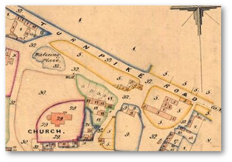
Tithe Award Map of Heddon (1848). Northumberland Archives, Ref. DT 229 M.
Plan of Heddon by Thomas Bell and sons (1856). Northumberland Archives, Ref. ZAN BELL 23–7.
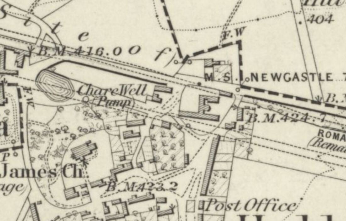
Ordnance Survey 6" to 1 mile, revised 1860, published 1865. National Library of Scotland.
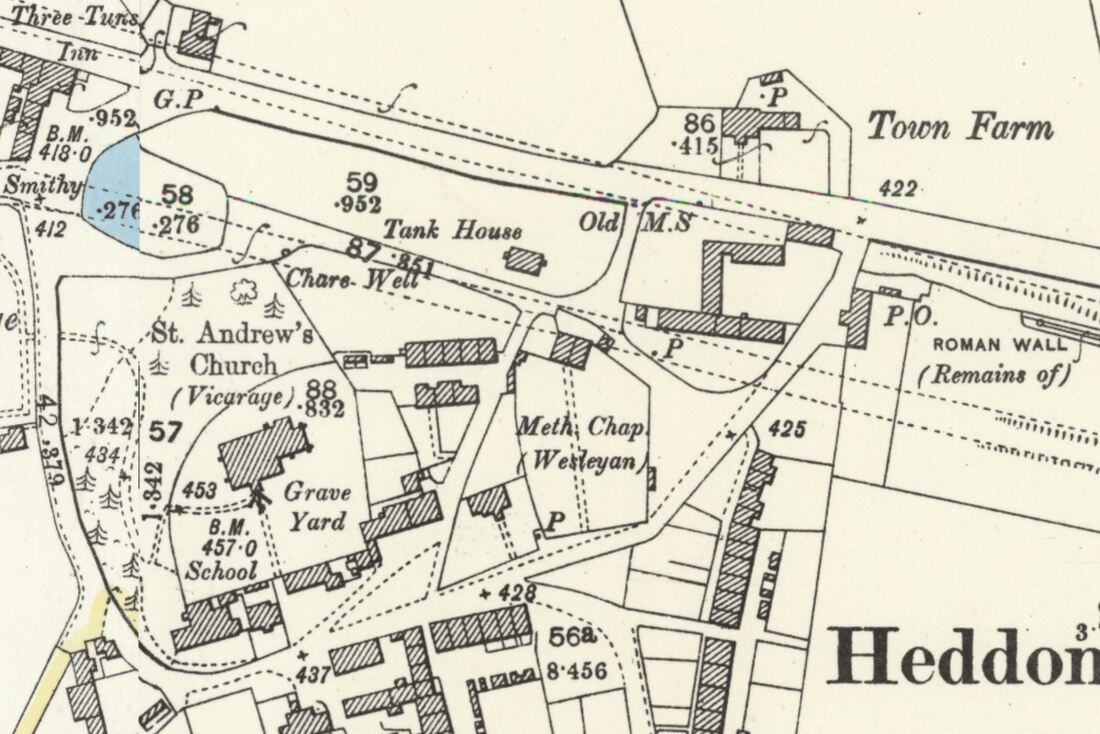
Ordnance Survey 25" to 1 mile, revised 1895, published 1897. National Library of Scotland.
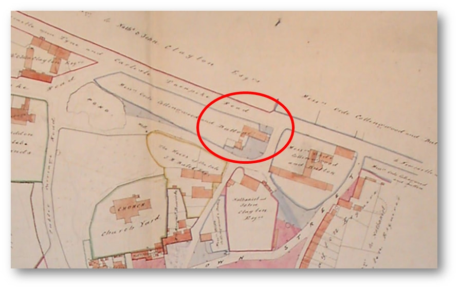
Plans show that Town Farm & the enclosure to its west (location of Tank House) were under the same ownership (numbered 5 on the Tithe Award Plan and named as ‘Messrs Orde, Collingwood and Dutton’ on Bell's Plan of 1856.
Stobbs reasons that:
The reason why Milecastle 12 was not located at the Town House farmyard in 1928 or in 2019, is that it actually sits some distance to the west, within the enclosure now known as Tank House Field (No. 1 on map). It might be objected that the eastern (Town Farm farmyard) possibility is one Roman mile from Milecastle 13, but it is well known that milecastles and turrets often lie slightly away from their measured positions for topographic reasons, and the higher ground of the Tank House enclosure may well have been preferred to the measured position. The site of the next milecastle to the east (11) is not established; measurement from its assumed position would place Milecastle 12 just to the west of the Town Farm site.
Archaeological evaluation work within Tank House Field has been quite limited and there is probable potential that remains of Milecastle 12 may well survive within the enclosure, probably to the north-west of the current dwelling house. This should be considered more likely to be the milecastle site than the Town Farm location.
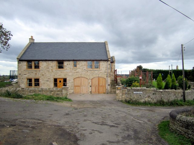
Tank House. View from the front of the house above Chare Bank. Photo A Curtis (2010).
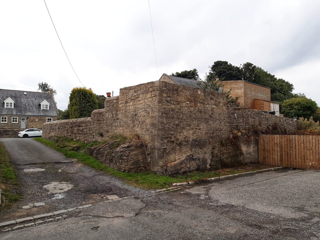
Rear wall of the back garden of Tank House above the (former) Military Road. Photo A Curtis (2022).
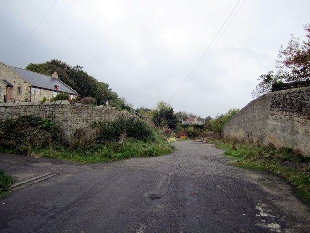
In the photo shown above, the old road runs in the foreground of the above photo from left to right. This was the line of the Military Road (constructed in the 1750s, mainly on the foundations of Hadrian's Wall) and later the course of the A69 from Newcastle to Carlisle. The road closed when the bypass was built. The line of the Wall here lies just south of the road (the Wall perhaps had already been flattened by building within the village).
The track on the left also cuts through bed-rock, runs up towards the rear of Garden House, and divides the enclosures of the original Town Farm and Tank House.
This location is close to the suspected site of Milecastle 12, although it has never been found. Recent archaeology has shown it wasn't in its measured position under the buildings of Town Farm (later Tulip's Haulage Yard) slightly further east.
The road was widened in 1926. At the same time, or perhaps earlier, it was cut deep into sandstone bedrock (visible below the wall) to remove an unnecessary hill. As the milecastle wasn't revealed on the line of Hadrian's Wall further east there is a high possibility that it is located somewhere on the hill in the garden above the wall, the back garden of Tank House. There were old buildings here above the road, indicated on old plans, and it might of course have been completely destroyed.
Old road near at the rear of Tank House. Photo A Curtis (2010).
UPDATE January 2023
Matthew Hobson (2021) proposes a more westerly location of MC12 "somewhere between the western boundary of the current development site and the Shell garage to the west that faces onto Hexham Road. Use of Ground Penetrating Radar could perhaps be used successfully to solve this long-standing question."
An archaeological watching brief at Heddon-on-the-Wall and the probable location of Milecastle 12 by Matthew S. Hobson. Archaeologia Aeliana, 5th series, vol. 50 (2021), pp. 115–132.
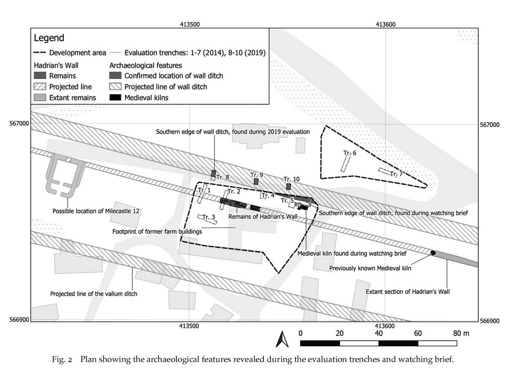
Two phases of trenched archaeological evaluation and a watching brief were conducted by Wardell-Armstrong LLP on two nearby plots of land, formerly belonging to Town Farm, and bisected by the projected line of Hadrian’s Wall at Heddon-on-the-Wall, Northumberland. The works were deserving of particular scrutiny because the measured location of Milecastle 12, one Roman mile east of the known location of Milecastle 13, falls squarely within the development area. Indeed, a discovery of a pivot stone, probably the northern gate of the milecastle, was recorded close to the west end of an outbuilding of Town Farm in 1926. A number of later investigations at Town Farm have recorded a high degree of truncation on the site and failed to locate traces of either the milecastle or of Hadrian’s Wall.
This has led to the commonly held belief that the remains of the milecastle were probably destroyed during the construction of farm buildings, or indeed earlier. The comprehensive redevelopment of the site, however, has allowed the collection of sufficient data to revisit this issue once again.
Two surviving sections of the Broad Wall were recorded during the watching brief over a 20-metre stretch, proving that later truncation had not removed the entirety of the Roman archaeology on this site. The southern edge of the Wall Ditch and its upper fills were observed in the north-east of the development area and in evaluation trenches excavated along the lane to the north. The only datable finds came from a medieval kiln of unknown function, situated between Hadrian’s Wall and the Wall Ditch. The kiln is similar in form to the one still visible at the western end of the extant stretch of the Wall, 70 metres to the east. This new discovery indicates that there may have been a group of such features in this area in use from approximately the mid-13th to mid-15th century AD. With the exception of the easternmost section of the Broad Wall and the medieval kiln, all of the archaeological discoveries were made within the area of the Scheduled Monument. Each of the significant archaeological deposits, including a buried land surface preserved beneath the Wall, was sampled, but no significant archaeobotanical results were obtained.
While no traces of Milecastle 12 were found, the work has led to the realisation that the discovery of 1926 was very probably made farther to the west than originally thought, where the now more accurately projected line of Hadrian’s Wall meets the former Carlisle to Newcastle main road.
Matthew Hobson (2021) proposes a more westerly location of MC12 "somewhere between the western boundary of the current development site and the Shell garage to the west that faces onto Hexham Road. Use of Ground Penetrating Radar could perhaps be used successfully to solve this long-standing question."
An archaeological watching brief at Heddon-on-the-Wall and the probable location of Milecastle 12 by Matthew S. Hobson. Archaeologia Aeliana, 5th series, vol. 50 (2021), pp. 115–132.
Two phases of trenched archaeological evaluation and a watching brief were conducted by Wardell-Armstrong LLP on two nearby plots of land, formerly belonging to Town Farm, and bisected by the projected line of Hadrian’s Wall at Heddon-on-the-Wall, Northumberland. The works were deserving of particular scrutiny because the measured location of Milecastle 12, one Roman mile east of the known location of Milecastle 13, falls squarely within the development area. Indeed, a discovery of a pivot stone, probably the northern gate of the milecastle, was recorded close to the west end of an outbuilding of Town Farm in 1926. A number of later investigations at Town Farm have recorded a high degree of truncation on the site and failed to locate traces of either the milecastle or of Hadrian’s Wall.
This has led to the commonly held belief that the remains of the milecastle were probably destroyed during the construction of farm buildings, or indeed earlier. The comprehensive redevelopment of the site, however, has allowed the collection of sufficient data to revisit this issue once again.
Two surviving sections of the Broad Wall were recorded during the watching brief over a 20-metre stretch, proving that later truncation had not removed the entirety of the Roman archaeology on this site. The southern edge of the Wall Ditch and its upper fills were observed in the north-east of the development area and in evaluation trenches excavated along the lane to the north. The only datable finds came from a medieval kiln of unknown function, situated between Hadrian’s Wall and the Wall Ditch. The kiln is similar in form to the one still visible at the western end of the extant stretch of the Wall, 70 metres to the east. This new discovery indicates that there may have been a group of such features in this area in use from approximately the mid-13th to mid-15th century AD. With the exception of the easternmost section of the Broad Wall and the medieval kiln, all of the archaeological discoveries were made within the area of the Scheduled Monument. Each of the significant archaeological deposits, including a buried land surface preserved beneath the Wall, was sampled, but no significant archaeobotanical results were obtained.
While no traces of Milecastle 12 were found, the work has led to the realisation that the discovery of 1926 was very probably made farther to the west than originally thought, where the now more accurately projected line of Hadrian’s Wall meets the former Carlisle to Newcastle main road.
DISCUSSION: THE PROBABLE LOCATION OF MILECASTLE 12
As noted above, the measured location of Milecastle 12 falls within the development area, more or less precisely at the north-west corner of the former farm buildings. The identification of preserved remains of Hadrian’s Wall at this location, in an area which had previously been assumed to have suffered complete truncation, warrants a reassessment of the probable location of this milecastle. The 2019 investigations have confirmed that the line of the Broad
Wall was positioned rather too far south to have been disturbed by the widening of the old Carlisle to Newcastle road in 1926 (referred to above). If the pivot stone discovered during the 1926 roadworks was indeed part of the in situ northern gate of Milecastle 12, the clear implication is that its location is likely to have been farther west, close to where the projected line of the curtain wall meets the remains of the old road. In our estimation the discovery of the pivot stone in 1926 is most likely to havebeen some 90m farther to the west than the measured location of the milecastle, as indicated on fig. 2.
Supporting the idea that the discovery in 1926 was made farther to the west, is the fact that in 1856 the development area and the neighbouring plot of land to the west were both
in possession of Messrs. Ord, Collingwood and Dutton. Stobbs (2020) has correctly observed that if these two plots of land could both be referred to as Town Farm, it would make sense of the fact that the pivot stone was described as having been found ‘close to the western end of an outbuilding of Town Farm’. The idea that the measured location of Milecastle 12 might have fallen west of the current development area, which he also refers to, cannot however be supported. The salient fact, which Stobbs does also note, is that the distance between the so called ‘milecastles’ varied depending upon the terrain and the need to communicate with forts on the Stanegate (Breeze 2006, 64–65). A discrepancy of 90m, between a measured hypothetical mile separating two adjacent milecastles and the actual distance, would be slightly more than the known average, but significantly less than the largest recorded discrepancy of more than 210m. The high level of truncation within the current development area leaves us with a high degree of uncertainty. It is still possible that the pivot stone was found during work linking up the east-west road with the north-south lane which separates these two plots of land. If any remains of the milecastle lay within the western half of the development area they are very likely to have been destroyed. The remaining uncertainty means that in future the location of the milecastle should be sought somewhere between the western boundary of the current development site and the Shell garage to the west that faces onto Hexham Road. Use of Ground Penetrating Radar could perhaps be used successfully to solve this long-standing question.
| aa5_50_2021_heddon_milecastle_12.pdf |
 RSS Feed
