Heddon-on-the-Wall Local History Society
  • Home
  • Calendar
  • Introduction
  • Where are we?
  • History Map
  • Timeline
    • Prehistoric
    • AD43 to 1599
    • 1600 to 1799
    • 1800 to 1899
    • 1900 to 1999
    • 2000 to 2099
  • Heddon's History
    • Prehistory
    • Hadrian's Wall >
      • Vallum excavation (1893)
      • Hadrian's Wall excavation 1926
      • Wall ditch, Bays Leap (1958)
      • Hadrian’s Wall: Archaeological research by English Heritage 1976-2000
      • Throckley & Heddon entanglements
      • WallWatch
      • English Heritage (2020)
      • Wardell-Armstrong Archaeolgy Reports
      • Historic England Archives
    • Six townships >
      • 1 Heddon township >
        • Heddon in the Middle Ages
        • Common Land
        • Middle Marches
        • Tithe Award
        • St Andrew's Church >
          • Stained Glass Windows
          • Churchyard
          • Monuments of church & churchyard (1991)
          • Monuments Page 2
          • Vicars of Heddon
        • Village property
        • Heddon Hall >
          • Sale of Heddon Hall 2012
        • Heddon Banks Farm
        • Frenchman's Row
        • Methodist Church >
          • Heddon Methodist Church Centenary 1877-1977
        • Men's Institute
        • Women's Institute
        • Welfare Field
        • Knott Memorial Hall
        • Memorial Park
        • Schools
        • River Tyne
        • Coal Mining
        • Quarrying
        • Water Supplies
        • Transport
        • Waggonway & Railway
        • Occupations from 1800
        • Miscellaneous
      • 2 West Heddon township
      • 3 East Heddon township
      • 4 Houghton & Close House township >
        • Close House
      • 5 Eachwick township
      • 6 Whitchester township
    • Rudchester
  • People
    • Sir James Knott
    • Cadwallader J. Bates
    • Richard Burdon
    • Hugh Sinclair (Tim) Swann
    • George Clark
  • Old Photos
    • Postcards
    • Old photos 1
    • Old photos 2
    • Old photos 3
    • Old photos 4
    • Old photos 5
    • Old photos 6
    • Old Photos 7
  • Old News
    • Community News
    • Letter from the Emigrant Clergy of Frenchman's Row (1802)
    • Alleged Brutal Murder at Heddon-on-the-Wall (1876)
    • Sad boat accident at Ryton (1877)
    • Coronation tree (1902)
    • 65 Years on a Ferry Boat (1929)
    • Come claim your kiss at Heddon (1953)
    • The Swan (1972)
    • Heddon WI (1987)
    • Church House (1966)
    • Happy return (1993)
    • Hexham Courant (1997)
    • Butterfly Garden (1999)
    • Foot & Mouth (2001)
    • Remembrance Day (1996)
    • Remembrance Day (2016)
    • RAF at Ouston (2007)
    • Close House Golf Course (2009)
    • Heddon pupils celebrate British heritage (2011)
    • Roman Wall Forge (2011)
    • Diamond Jubilee (2012)
    • Auction of Bronze Statue, Close House (2012)
    • Heddon WI (2012)
    • Puffing Billy Festival (2013)
    • Heddon Village Show (2014)
    • View of the North (2014)
    • The Wall at Heddon (2014)
    • Heddon Village Show (2015)
    • War veterans singing send-off (September 2015)
    • Anglo-Saxon history (2014)
    • Heddon WI at 100 (2017)
    • Hadrian's Wall discovery (2019)
    • Tulip Mews (2020)
    • Mike Furlonger
    • Hadrian's Wall 1900 Festival
  • Memories
    • Olive White
    • Betty Cockburn
    • Betty Cockburn - miscellaneous information
    • Isabel Snowdon
    • William & Winnie Watson
    • Edith Ward
    • Mark Parker
    • Jack Lawson
    • Winnie Spoor
    • P Reay
    • Mr and Mrs Hall
    • Peter Chapman
    • Elizabeth Elenora Eames
    • Harry Murray
  • Other documents
    • Mackenzie (1825)
    • Bates (1886) >
      • Early & Roman
      • Townships
      • Heddon Church
      • Heddon & Houghton
      • Whitchester
      • Eachwick
      • West & East Heddon
      • Records
      • Addenda
      • Appendix A
    • History, Topography & Directory of Northumberland (Bulmer's) - 1886
    • History of Northumberland (1930)
    • Collingwood Bruce (1853)
    • Whellan (1855)
    • Post Office Directory (1879)
    • Prominent people in Heddon
    • Place names
    • Ad Murum
    • Archived documents
    • Thomas Bewick's History of British Birds (1826)
    • Census data 1801-1991
    • Historical Records 1888-1890
    • Knott Sale of Village Property (1924)
    • Extracts from Parish Council Records
    • Local colliery records
    • Blackburn (1938)
    • Clark (c.1963)
    • History of Church (1968)
    • Boundary Commission Report 1984
    • Village Atlas 2022
  • Walks
    • Walks 2
  • Blog
  • Contact us
  • Links
  • What's new
  • Site search
  • Past & Present
  • Photo of the Month
  • Place Name Studies
    • Meas & Meres
    • OS Name Books: Elsdon
    • OS Name Books: Allendale
    • OS Name Books: Cheviot Hills

Village development in 1960s

25/10/2017

0 Comments

 
Picture
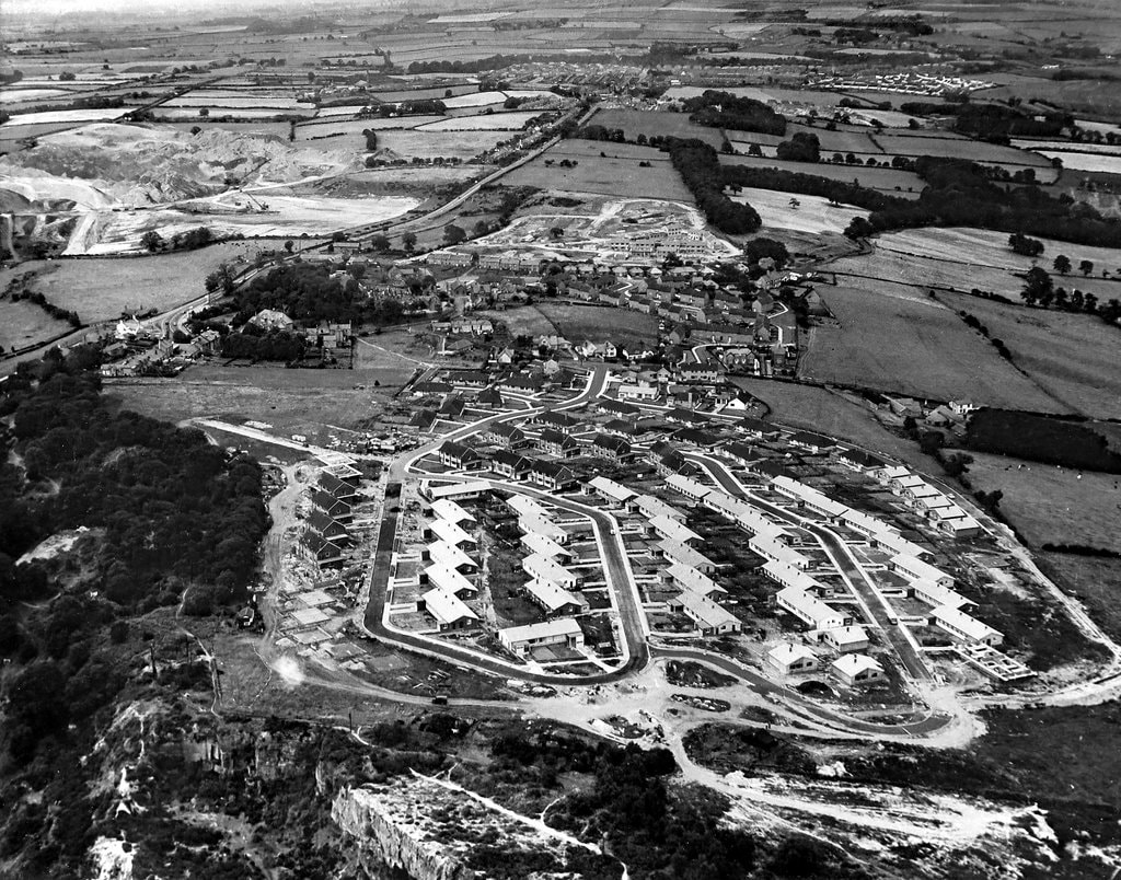
Aerial photo of Heddon village looking east (1961)
Although the above photo already features on this site, a much better resolution of it has become available today courtesy of Isabel Tooze, daughter of the former Heddon historian, George Clark.

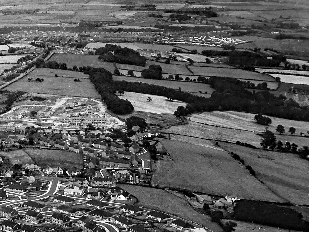
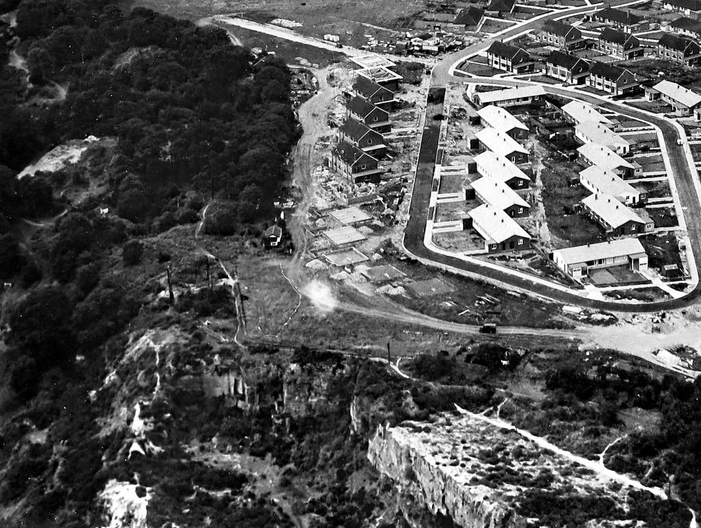
This has enabled me to produce the following cropped images.
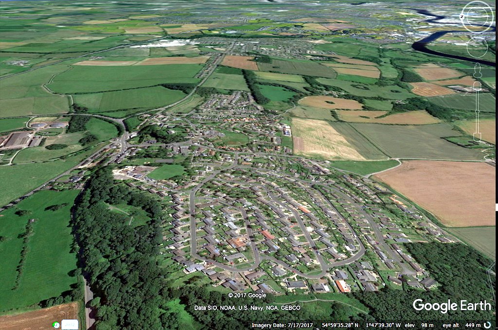
This would make a good Past & Present but I would need an aeroplane or at least a drone to take my own present photo. Below is an image from a similar viewpoint generated by Google Earth.
Picture
For those who understand such things, below is a Google Earth (kmz) file which you can download to your PC and double click to open the view at the same location.
heddon_on_the_wall.kmz
File Size: 0 kb
File Type: kmz
Download File


Village development in the 1960s
Article published in Heddon Gossip, December 2017

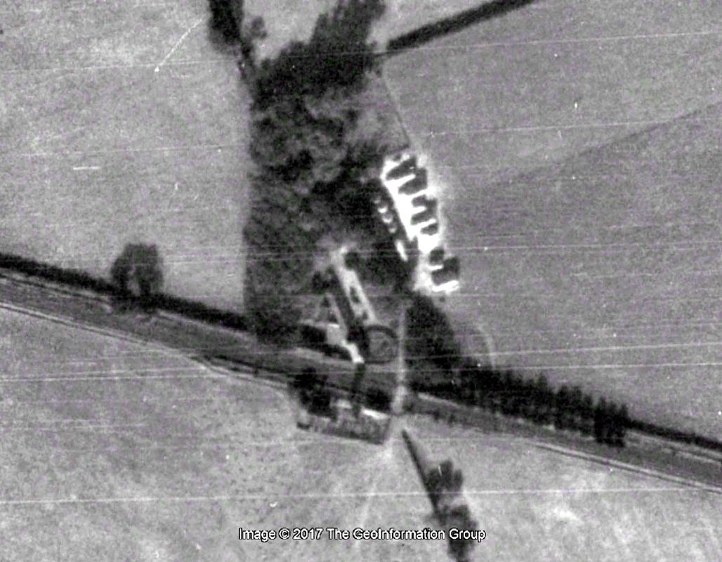
Today I want to discuss just one photograph in our collection that was taken at probably the most important time for our village. It was the time when housing developments on both the west and east sides saw an expansion of Heddon from its original tiny core around St Andrew’s Church, greatly increasing the population and making it the dormitory village it is today.
You can view the photograph on the Heddon Local History website above.
The photo I am describing is a black and white aerial photograph of the village taken from a location high above the quarries on Heddon Common looking east towards Throckley. It dates from around 1961, some 56 years ago. Who flew the plane and took the photo I don’t have recorded; I think it may have been one of the local newspapers or even publicity to sell the new houses.
We had a small copy of the photo for some time but an enlargement of 15 x 12 inches recently came to me courtesy of the daughter of George Clark, our former village historian.
The focus in the foreground is mainly on the Bainbridge Estate. The name comes from George Bainbridge, a local builder. It shows many newly built houses and bungalows, neat drives (with the gravel centre where my wild strawberries grew on Aquila Drive) and pristine white pavements. Some houses on the outside edge of this estate are still only foundations or as yet un-started.
Killiebrigs and the lower properties of Heddon Banks came even later.
East of the village is another building site for the Vallum Estate (Craigie was the builder) with the roads laid out, but only a few houses completed, mainly on Valerian Avenue.
Grass fields run from beside the old Post Office on Hexham Road. The Welfare Field (park) is little more than a field but next to it another field would eventually be the site of the new school. Building was started in 1962, held up by the severe winter weather and completed in 1963. The shops in Taverna Place were built around the same time.
In the older part of Heddon between the two estates, many of the old properties have been demolished, including the Square Yard adjacent to the Swan, Mushroom Row, and Jubilee Houses near the modern library. The single storey houses that made up the north part of the terrace of Blue Row were removed to provide access to the Vallum estate. Centurion Way had already been built to connect Heddon Banks and Station Road, and the bungalows of Overhill and the Council houses were completed.
The Three Tuns is very prominent on the left side of the photo and the Hexham Road makes a sharp S-bend in front, as the Co-op store still occupies the old smithy that jutted out from it opposite the Memorial Park. Later, this was partly demolished, the road realigned, and Throckley Co-op relocated to its new store on Taverna Close (now the children’s nursery).
The straight line of the old road through Heddon to Throckley and Walbottle (largely on the line of Hadrian’s Wall) makes a prominent diagonal on the left side. This was the old A69. Beyond it, the fields have been devastated by open-cast coal mining with an access road provided just beyond where there are now trees on the Great Hill, close to where the houses start on Throckley Road. The new road layout in Heddon to the north of the farmhouse of Town Farm would come later with reinstatement of the land and the new A69 bypass to the north.
In the distance you can just make out the Throckley Isabella pit and the pit at North Walbottle before the view east is lost in 1960’s smog towards Newcastle.
This would make a good photo for a Past & Present comparison but you would need an aeroplane or at least a drone to take the present photo. On the website you can find one I have made from a modern aerial image from a similar viewpoint flying with Google Earth.
0 Comments

Almost like being there yourself!

23/10/2017

0 Comments

 
I've been trying out some new software from my local archaeology group that makes 3D models from a set of digital photos.

Below is my trial of the west end of Heddon's preserved section of Hadrian's Wall.

It is for those who are not able to visit it (or sit on it, as I do from time to time). Click the big arrow to load the model, use the controls to alter rendering and the computer mouse to rotate (left-button and drag), pan (right button and drag) and zoom (wheel or ctrl-drag). For the truely immersive experience switch on full-screen mode!

It's just like being there yourself.

Hadrian's Wall, Heddon on the Wall, UK by NOWTAG on Sketchfab

Shown here is a short section of Hadrian’s Wall at the west end of a length of preserved Wall about 255m long, consolidated and in the care of English Heritage, just east of Heddon on the Wall village. This represents a part of the planned ‘broad wall’; further west the structure was reduced in thickness to save time and resources.

The broad wall at Heddon is between 2.8m and 3m wide and up to 1.7m (7 courses) high. The rubble core was originally set in puddled clay, but was reset in mortar to preserve the section when it was consolidated. The first 12m at the west end has only the outer face exposed.
At the west end (NZ 13622 66942) a circular kiln was built into the wall in medieval times, probably to dry corn. It measures 1.9 m in diameter, has a paved floor, and the surrounding wall has a maximum height of 0.7 m (3 courses). The flue is in the south-west arc and is 1.4 m wide.
For those missing a visit to St Andrew's Churchyard, please see the 3D model below.

Table-tomb, St Andrew's, Heddon on the Wall by NOWTAG on Sketchfab

A flat-topped, table- or chest-tomb from the late eighteenth century, located in the graveyard close to the west end of St Andrew’s Church, Heddon on the Wall, UK. There are inscriptions on the top and on the two end slabs and on the south-facing side of a long slab concealed beneath, but these are not well resolved in the 3D model and largely captured by the texture.

The inscriptions are transcribed on this site under number [90] where there are also some standard, 2D photos.

If you are more interested in prehistoric rock art, there is another model here.
0 Comments

William Ward Sanderson (1874-1963)

14/10/2017

0 Comments

 
A couple of old photos kindly copied from Philip Sanderson of his father William Ward Sanderson. Some of the information below is taken from a previous blog after a talk to our Society by Philip entitled 'The House that Fell over the Cliff' in 2011.

William Ward Sanderson (1874-1963) was born at Dale House Farm near Whitby. He became interested in agricultural engineering and the pioneering use of steam engines for ploughing and threshing. After studying at Wye College, he had various jobs servicing and selling farm implements throughout the country and, for three years, in South Africa.

In 1927, William moved back to the north-east working for the Northern Agricultural Supply Company in Newcastle. He rented East Town Farm in Heddon on the Wall which was owned at the time by James Hedley of Bays Leap Farm.  The family lived in the farmhouse and farmed successfully on the fields here, milking cows in a parlour (now part of Tulip's yard), cutting hay on the site of the Roman Wall and running a local shop selling cigarettes and confectionery.

William Sanderson served for many years on the Parish Council, including a stint as Chairman in 1949.
Picture
William Ward Sanderson, agricultural engineer and pioneer, died on 13th May 1963 at Ponteland, to where he had retired when East Town farm was sold for the building of the Vallum Estate in the 1950s.
Picture
Photo from Philip Sanderson (2017)
Picture
John & Philip Sanderson 1950. Photo from Philip Sanderson (2017)
0 Comments

William Harle

5/10/2017

0 Comments

 
William Harle was station-master at Heddon on the Wall Railway Station between 1898 and 1906. It has been said that he planted 13 trees at the station, one for each of his children. As pointed out on Disused Stations a line of trees extends east of the platform buildings on a photograph from 1910 shown below.
Picture
Heddon on the Wall Station, view east of platform for Newcastle, c.1910.
The line of trees is also visible in historical aerial imagery for 1945 on Google Earth. The railway line runs from left to right across the photo. The Newcastle platform lies east of the level crossing which provided access to the Station-master's House and fields to the south. The platform was on the north side and I can count 14 or 15 trees extending to the east on the extract below. The station was staggered and the platform for travellers to Wylam was just west of the level crossing, close to the Station-master's House.
Picture
Google Earth aerial image from 1945.
There is a line of mature sycamore trees along the boundary in this location today but now many more trees have grown up both west and east along the line of the Wylam Waggonway, and an exact count is not easy. The Station-master's House is still in use as the farmhouse of Heddon Haughs Farm, located at the bottom of Station Road, just to the north of the station, although the building has been much extended and altered

A newspaper clipping shown below describes how 14 trees were planted in commemoration of his 14 children, to mark the Coronation of King Edward VII.
The 1901 Census records William Harle (aged 46),  wife Margaret (44), and 8 children: Ethel May (17), Isabella (15), Margaret (13), Lillian (10), William (8), Mabel (5), Sidney (2) and Ernest Edward (0). The Census fails to record the number of rooms in the Station Masters House but lodging with them at the time was a William W Watson (23), Railway Signalman (born in Newcastle).
I was pleased to have recently received more information about William Harle and his family from his great grandson, Brian Harle, who has kindly let me reproduce it here.
5b2    William (1854-1913)      
 
The previous section on his father George (6b3) indicates the poor living conditions to which this family had been reduced since the break up of Corridge. His birth certificate shows he was born at New Cassop, which lies a few miles south east of Durham City.

The family had moved to Trimdon by 1859 when his sister Mary was born and there was a church school here so he would probably have some education, the School Board Act was not introduced until 1870. The 1871 census shows him working as a stoker at Usworth Colliery at the age of 16 years. He must have obtained work on The North Eastern Railway soon after this as his marriage certificate dated 1875 gives his occupation as Block Instructor.

By the last quarter of the 19th century the laying of railway lines all over the country was almost completed and travelling by rail was so well established that a large number of trains was using each line and several accidents were occurring, According to W W Tomlinson's book "The North Eastern Railway" there had been several of these accidents on the NER in the 1860's due to incorrect signalling and experiments were being carried out with a system of block signalling designed to prevent any train entering a section of the railway which already has a train on it. As a result of serious accidents at Thirsk in 1869 and at Brockley Whins near Boldon, in 1870 it was decided in May 1871 to apply the block system to the whole of the NER system and "To arrange for the establishment of classes in which pointsmen, signalmen and other servants of the company might be instructed and trained to perform efficiently the duties required of them,"
 
It is assumed that the NER advertised for men to be trained as instructors and William was one those selected and hence is designated a 'Block Instructor' on his marriage certificate.

He and his bride Margaret Ann Mariner lived close together as the 1871 census shows their families adjacent to each other:-
 
            At 57 Old Engine
Matthew Mariner        Head   39        Coal Miner      Birtley
Isabella Mariner         Wife    33                                Washington
Margaret Ann Mariner Daughter    14                      Washington                 Thomas Mariner       Son           9          Scholar      Washington                 Jonas Mariner           Son          5                             Washington
Robert Mariner          Son          3                             Washington


            At 58 Coxons Row, Usworth
George Harle         Head               45        Labourer          Witton Gilbert
Isabella Harle         Wife                38                                Pelton
Robert Harle          Son                 18        Labourer          Cassop
William Harle         Son                 16        Stoker              Cassop
Mary Harle           Daughter           12                                Trimdon
 

The first child was born four months after their marriage, so the addresses on the certificate are probably false, and was used to avoid having the banns read at the local church, few neighbours at Washington would hear any details of weddings at North Shields in those days.

It will be seen that Margaret's father was a labourer but it is known from the previous census that he had been a coal miner and was born at Birtley, her mother was Isabella and some idea of Margaret's family can be obtained from these extracts from a letter from Mabel Topping (nee Harle) c1971.
 
"I'm afraid I do not know much about my father really. I was only a small child, about seven when he remarried. I cannot remember any of his people coming to stay or even hearing of them. He had one sister, Mrs Hall who I met once she lived at Low Fell if I remember rightly. Both my mother and father came from the same village, Usworth near Washington, My mother Margaret Ann Mariner had three brothers Jonas, Thomas and William and a sister Mrs Rutherford who lived in Jesmond. I knew uncles Thomas and William's families very well, they were very good to me, they all lived around Washington and their families live there today. My maternal grandmother, when I knew her was Mrs Pringle having remarried. Uncle Jonas was manager of a working men’s club in Usworth or thereabout. I only met him in 1936."
 
The first child mentioned above was Mary Alice born at Brandy Row Washington on the 7 December 1875 and the certificate gives William's occupation as signalman, it was quite common for women to go home to mother to have the first child so William and Margaret may have had a home away from Brandy Row perhaps a railway house.

By the February of 1881 the family had moved to Harvey Street in Heaton, Newcastle Upon Tyne, William is still a signalman but will have been upgraded and is probably in one of the larger signal boxes on the main London - Edinburgh line.

They lived in Harvey Street until 1889 when they moved to Tynemouth Road not far away. It can be assumed that William had a few promotions during the ten years they lived at Tynemouth Road as his next move was when he was appointed stationmaster at Heddon on the Wall, quite an important position in those times when the railways were the most important means of transport. It must have been a great blessing to Margaret to have a large detached railway house after living in a small terrace house, since by this time their family had grown to ten, seven girls and three boys, the oldest only fourteen years of age. The railway is long since gone but the station house is still occupied and was only recently modernised.

Margaret had one more child, Ernest Edward in 1901, the last to have a tree planted in his name as shown in a cutting from the Hexham Courant. (The original dated 19 August 1903). She did not have the pleasure of living in the large house for very long as she developed pneumonia in the first days of 1903 and died of heart failure on the 13th January. They had fourteen children in the twenty years of their marriage, three had died and the oldest two were married leaving William with nine still to be looked after.

From Mabel's letter (op cit) it would seem that Margaret's family were very helpful with the younger ones and may have had some of them to stay at Usworth. As a stationmaster William may have had domestic staff but even so the long-term solution to his problem would be to employ a nanny. It is thought that Mary Henderson was chosen for this position but whether this is true or not William was definitely married to her before the year was out.

Mary Annie Henderson was the daughter of Luke and Jane and was baptised at Whittingham Parish Church, Northumberland, Octavia Annie, it is not surprising that she changed the first name to Mary when she was a few years older. Luke's first wife Margaret was a local girl and they were married at Whittingham but his second marriage to Mary's mother Jane took place elsewhere and the certificate has not yet been found. Mary's address on the certificate is Glanton, which is close to and in the parish of Whittingham and could be where her mother was living so if her brother and sisters were still in the area her family would be well represented at her wedding. Mary was fifteen years of age when her father died so she should have remembered his name and occupation, which for some reason are omitted from the marriage certificate.

Not long after his second marriage William added a codicil to his will omitting his daughter Lilian out of any benefit. She left home and went to live with her mother's family, whether she left of her own free will or was forced to leave is not known but all the older children also left home as soon as it was conveniently possible.

Matthew immediately went to live with his sister Kate, married and living in the west end of Newcastle, and Margaretta left home and went into service at Ebchester, Alice and probably Ethel were already married. Isabella if not married at this time was married soon after but she kept in touch with the family as a postcard dated April 1908 confirms. The postcard is from William who is 15 years old and still at home, to Barbara Watson a sister of Isabella's husband.

The family moved to Appleby c1906 and William was stationmaster here until 1913, when he retired due to ill health and moved back to Newcastle. He died at Bolingbroke Street, Heaton in May of the same year and their last child was born some months later. Mary and the family continued to live in Heaton until about 1925 when they moved to a farm at Blencarn, at the foot of Cross Fell in Cumbria, Mary died at Barningham in Yorkshire in February 1947 at the age of 72 years.
 
William and his two wives had 18 children 4a1 to 4a18.
Picture
Picture
William Harle (1854-1913).

Information provided by Elizabeth Hogson
January 2022

I have just re-read your article on William Harle and am keen to have the correct information regarding his second wife recorded.

Mary Henderson was the daughter of Isabella Henderson who was born at Wandon, nr Wooler in Northumberland ( I have Isabella’s death certificate on which it states that the informant was William Harle her son-in law).  At the time of Mary’s birth Isabella was unmarried.

Further information on the wedding certificate dated 23rd September, 1903 are the witnesses – Margaret Henderson her sister, James Walker her uncle (married to Isabella’s sister Mary) and Mary Luckley.

Mary is the grand-daughter of James and Mary Walker, her mother being Margaret Ann Walker who married Thomas Luckley.

My great grandmother is Margaret Henderson sister of Isabella and Mary.


0 Comments

    RSS Feed

    Author

    Andy Curtis

    Archives

    February 2023
    November 2022
    September 2022
    August 2022
    June 2022
    May 2022
    January 2022
    December 2021
    November 2021
    September 2021
    August 2021
    June 2021
    May 2021
    October 2020
    June 2020
    May 2020
    March 2020
    November 2019
    August 2019
    July 2019
    March 2019
    January 2019
    November 2018
    October 2018
    August 2018
    July 2018
    June 2018
    April 2018
    March 2018
    January 2018
    October 2017
    September 2017
    July 2017
    June 2017
    May 2017
    April 2017
    March 2017
    February 2017
    January 2017
    December 2016
    November 2016
    September 2016
    August 2016
    July 2016
    June 2016
    May 2016
    April 2016
    February 2016
    January 2016
    December 2015
    October 2015
    September 2015
    August 2015
    July 2015
    June 2015
    May 2015
    April 2015
    March 2015
    February 2015
    January 2015
    December 2014
    November 2014
    September 2014
    August 2014
    July 2014
    June 2014
    May 2014
    April 2014
    March 2014
    February 2014
    January 2014
    December 2013
    October 2013
    September 2013
    August 2013
    July 2013
    June 2013
    May 2013
    April 2013
    March 2013
    February 2013
    January 2013
    December 2012
    November 2012
    October 2012
    September 2012
    August 2012
    July 2012
    June 2012
    May 2012
    April 2012
    March 2012
    December 2011
    November 2011
    October 2011
    September 2011
    August 2011
    June 2011
    May 2011
    April 2011
    March 2011
    February 2011


    Categories

    All
    Agricultural Engineering
    Archaeology
    Barrow
    Bays Leap
    Beamish Museum
    Beer
    Beer-mat
    Bewcastle
    Books
    Border Line
    Brewery
    Brown
    Cabinetmaker
    Charlton
    Cheviots
    Churches
    Civil War
    Clennell Street
    Close House
    Coal Mining
    Cullercoats
    Cumbria
    Eachwick
    Earl Grey
    Elswick
    Family History
    Fishing
    Fishwives
    Folkestone Warren
    Forth Banks
    Furniture
    Gardens
    General
    George Clark
    Gibson
    Goods Station
    Hadrian's Wall
    Harbours
    Heddon
    Heddon Hall
    Hexham
    Hidden Chains
    Houghton
    Howick Hall
    Hunting
    Iron Sign
    Isaac Jackson
    John Grundy
    John Smith
    Knott
    Landslide
    Lead Works
    Lemington
    Lindisfarne
    Maritime
    Meetings
    Military Road
    Mill
    Monument
    Newburn
    Newcastle
    Newcastle Assizes
    News
    North Lodge
    North Shields
    Northumberland
    Northumberland Records Office
    Old Middleton
    Oral History
    Ouseburn
    Outings
    Photography
    Place Names
    Place-names
    Ponteland
    Ports
    Prehistory
    Pubs
    Quarries
    Railways
    Redesdale
    River Tyne
    Rock Art
    Roman
    Sadler
    Sanderson
    Schools
    Seaton Delaval
    Ships
    Shot Tower
    Slave Trade
    Songs/Poems
    Spearman
    Stagecoach
    Stained Glass
    St. Andrews
    Stephenson
    Swann
    Tea Robbery
    Throckley
    Town Farm
    Transportation
    Trinity House
    Victorian Panorama
    Walbottle
    Walk
    Water Supply
    William Brown
    Williamson
    Woodhorn
    Ww1
    Ww2
    Wylam
    Yetholm

Powered by Create your own unique website with customizable templates.