Heddon-on-the-Wall Local History Society
  • Home
  • Calendar
  • Introduction
  • Where are we?
  • History Map
  • Timeline
    • Prehistoric
    • AD43 to 1599
    • 1600 to 1799
    • 1800 to 1899
    • 1900 to 1999
    • 2000 to 2099
  • Heddon's History
    • Prehistory
    • Hadrian's Wall >
      • Vallum excavation (1893)
      • Hadrian's Wall excavation 1926
      • Wall ditch, Bays Leap (1958)
      • Hadrian’s Wall: Archaeological research by English Heritage 1976-2000
      • Throckley & Heddon entanglements
      • WallWatch
      • English Heritage (2020)
      • Wardell-Armstrong Archaeolgy Reports
      • Historic England Archives
    • Six townships >
      • 1 Heddon township >
        • Heddon in the Middle Ages
        • Common Land
        • Middle Marches
        • Tithe Award
        • St Andrew's Church >
          • Stained Glass Windows
          • Churchyard
          • Monuments of church & churchyard (1991)
          • Monuments Page 2
          • Vicars of Heddon
        • Village property
        • Heddon Hall >
          • Sale of Heddon Hall 2012
        • Heddon Banks Farm
        • Frenchman's Row
        • Methodist Church >
          • Heddon Methodist Church Centenary 1877-1977
        • Men's Institute
        • Women's Institute
        • Welfare Field
        • Knott Memorial Hall
        • Memorial Park
        • Schools
        • River Tyne
        • Coal Mining
        • Quarrying
        • Water Supplies
        • Transport
        • Waggonway & Railway
        • Occupations from 1800
        • Miscellaneous
      • 2 West Heddon township
      • 3 East Heddon township
      • 4 Houghton & Close House township >
        • Close House
      • 5 Eachwick township
      • 6 Whitchester township
    • Rudchester
  • People
    • Sir James Knott
    • Cadwallader J. Bates
    • Richard Burdon
    • Hugh Sinclair (Tim) Swann
    • George Clark
  • Old Photos
    • Postcards
    • Old photos 1
    • Old photos 2
    • Old photos 3
    • Old photos 4
    • Old photos 5
    • Old photos 6
    • Old Photos 7
  • Old News
    • Community News
    • Letter from the Emigrant Clergy of Frenchman's Row (1802)
    • Alleged Brutal Murder at Heddon-on-the-Wall (1876)
    • Sad boat accident at Ryton (1877)
    • Coronation tree (1902)
    • 65 Years on a Ferry Boat (1929)
    • Come claim your kiss at Heddon (1953)
    • The Swan (1972)
    • Heddon WI (1987)
    • Church House (1966)
    • Happy return (1993)
    • Hexham Courant (1997)
    • Butterfly Garden (1999)
    • Foot & Mouth (2001)
    • Remembrance Day (1996)
    • Remembrance Day (2016)
    • RAF at Ouston (2007)
    • Close House Golf Course (2009)
    • Heddon pupils celebrate British heritage (2011)
    • Roman Wall Forge (2011)
    • Diamond Jubilee (2012)
    • Auction of Bronze Statue, Close House (2012)
    • Heddon WI (2012)
    • Puffing Billy Festival (2013)
    • Heddon Village Show (2014)
    • View of the North (2014)
    • The Wall at Heddon (2014)
    • Heddon Village Show (2015)
    • War veterans singing send-off (September 2015)
    • Anglo-Saxon history (2014)
    • Heddon WI at 100 (2017)
    • Hadrian's Wall discovery (2019)
    • Tulip Mews (2020)
    • Mike Furlonger
    • Hadrian's Wall 1900 Festival
  • Memories
    • Olive White
    • Betty Cockburn
    • Betty Cockburn - miscellaneous information
    • Isabel Snowdon
    • William & Winnie Watson
    • Edith Ward
    • Mark Parker
    • Jack Lawson
    • Winnie Spoor
    • P Reay
    • Mr and Mrs Hall
    • Peter Chapman
    • Elizabeth Elenora Eames
    • Harry Murray
  • Other documents
    • Mackenzie (1825)
    • Bates (1886) >
      • Early & Roman
      • Townships
      • Heddon Church
      • Heddon & Houghton
      • Whitchester
      • Eachwick
      • West & East Heddon
      • Records
      • Addenda
      • Appendix A
    • History, Topography & Directory of Northumberland (Bulmer's) - 1886
    • History of Northumberland (1930)
    • Collingwood Bruce (1853)
    • Whellan (1855)
    • Post Office Directory (1879)
    • Prominent people in Heddon
    • Place names
    • Ad Murum
    • Archived documents
    • Thomas Bewick's History of British Birds (1826)
    • Census data 1801-1991
    • Historical Records 1888-1890
    • Knott Sale of Village Property (1924)
    • Extracts from Parish Council Records
    • Local colliery records
    • Blackburn (1938)
    • Clark (c.1963)
    • History of Church (1968)
    • Boundary Commission Report 1984
    • Village Atlas 2022
  • Walks
    • Walks 2
  • Blog
  • Contact us
  • Links
  • What's new
  • Site search
  • Past & Present
  • Photo of the Month
  • Place Name Studies
    • Meas & Meres
    • OS Name Books: Elsdon
    • OS Name Books: Allendale
    • OS Name Books: Cheviot Hills
    • OS Name Books: Other Parishes
  • Heddon 3D landscape

Victorian Panorama by Alan MorganĀ  12 November 2012

17/11/2012

0 Comments

 
Picture
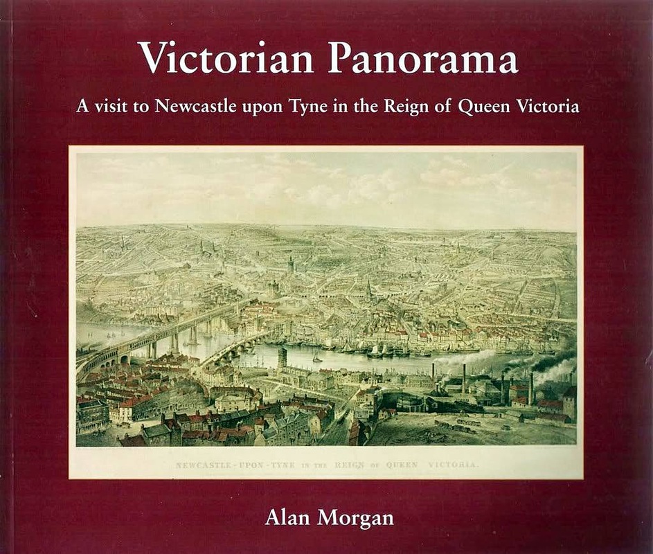
Victorian Panorama: a visit to Newcastle upon Tyne in the Reign of Queen Victoria by Alan Morgan, Tyne Bridge Publishing, 2007).
At short notice, due to a cancellation in our program of talks, the Newcastle City Guide, Alan Morgan, gave us an excellent talk on his book, the cover of which is shown above.
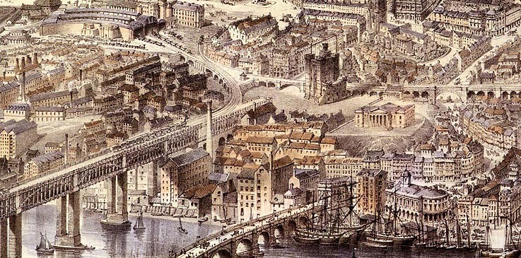
The basis of his book was the watercolour painting, Newcastle upon Tyne in the Reign of Queen Victoria, by John Storey (1862) and a lithograph of it Alan had seen in the Newcastle City Library. It shows a highly detailed view of the streets and buildings of the city at that time, taken from a vantage point high above Gateshead's former railway station, Brandling Junction.
Picture
There has been much interest since publication of the book.

How did John Storey achieve this lofty viewpoint? Did he have access to a balloon?

How did he manage to represent certain buildings and landmarks that were not yet built at the time of painting? These include the Tyne Brewery (1868), St Mary's Cathedral spire (1872) and the Tyne Tees Shipping Office (1875). How did the painter manage to predict the future? These buildings had been long planned, and John Storey presumably had access to the plans.
Picture
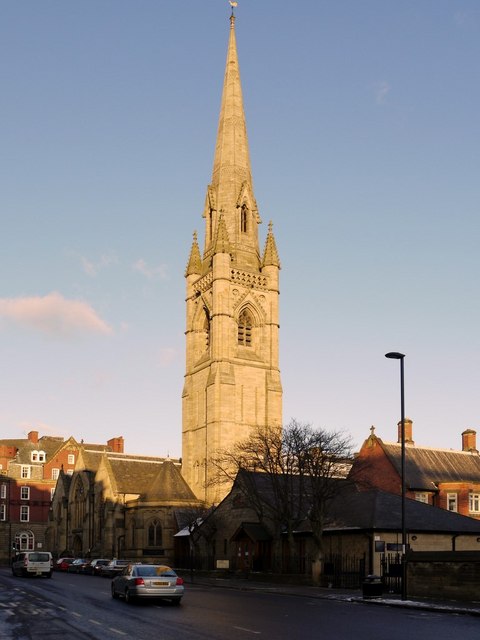
St Mary's Cathedral, Clayton Street West. Photo by A Curtis (2010).
Picture
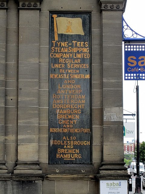
Tyne-Tees Steam Shipping Company, King Street. Photo by A Curtis (2010).
The book divides the painting into 13 areas covering a great swathe of Newcastle from the Tyne west of the High Level Bridge, to The Swirle on the Quayside (then a stream flowing into the Tyne), to the east. Detail is visible as far north as The Great North Road, Town Moor and Jesmond. Gateshead is also represented directly below the viewpoint. For each of these areas we are treated to detailed illustrations from the painting with added street names, and highlighted buildings which are numbered and discussed in detail in the text.

There are a large number of other illustrations and photographs from the period, and many old maps, which provide context and scale as the painting was done with some element of distortion and artistic license.
Picture
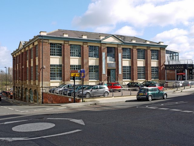
The Biscuit Factory, Stoddart Street, Shieldfield. Photo by A Curtis (2010).
I have had an interest for some years in the history of Newcastle's buildings and I found this book a wonder. Many of the old buildings can still be found although now have other uses as my example above of the Biscuit Factory shows.
Picture
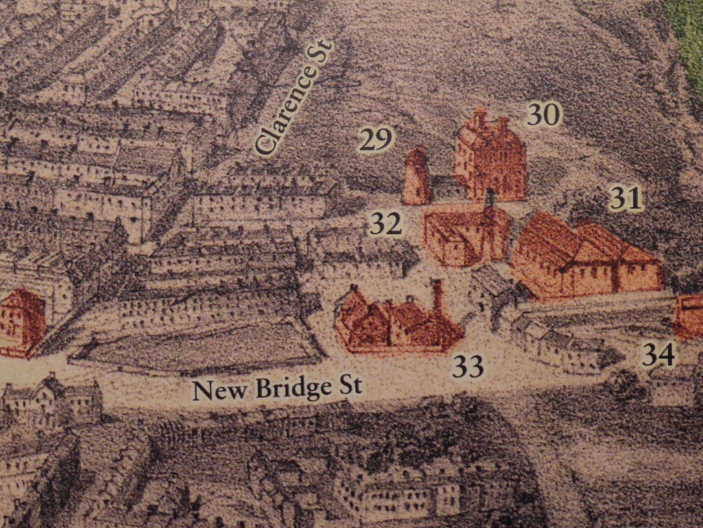
Small section from the book showing the Biscuit Factory in 1862 (no. 30).
Many of the buildings surrounding the Biscuit Factory have now gone, including the windmill shown at its front. Built in the late 1860s, the factory itself was run by Thomas Squire & Sons to make biscuits until just before the First World War and had several uses there after.
It is now Europe's largest commercial art gallery (opened in 2004). There is a history of the building here.
Picture
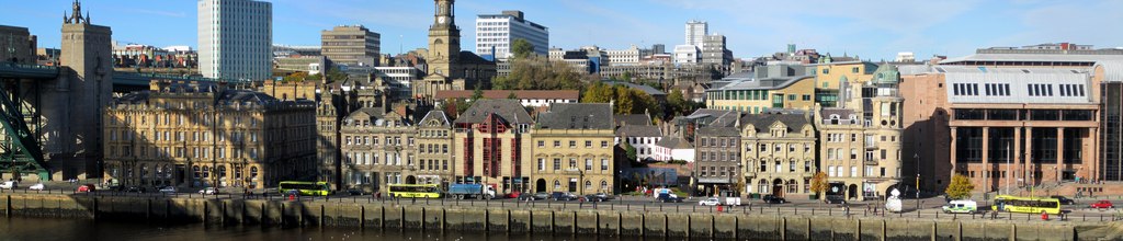
Newcastle Quayside panorama. Photo by A Curtis (2010).
Just for fun, two modern panoramas of Newcastle. Above taken from the Sage, Gateshead not far from Storey's viewpoint but much lower.

On the right, the sculptural map from Neville Street, across the road from Central Station. Click the photos for more detailed description of what you can see.
Picture
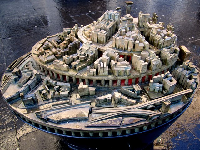
Grainger Town Sculptural Map, Neville Street. Photo by A Curtis (2010).
Links

Article by Tony Henderson in the Newcastle Journal (2007)
0 Comments

Oswald's Northumbria by Max Adams 10 October 2012

10/11/2012

0 Comments

 
Picture
Cross at Heavenfield marking the place where Oswald defeated Cadwallon in AD634. Photo by David Dixon (2012).
All photos © Copyright individual photographer and licensed for reuse under this Creative Commons Licence
Oswald (c 604 – 5 August 642) was King of Northumbria from 634 until his death, and was venerated as a saint in the Middle Ages.

Oswald was the son of Æthelfrith of Bernicia. After spending a period in exile on Iona where he was trained and educated by Irish monks, he returned to Northumberland and defeated the British ruler Cadwallon, Oswald brought the two Northumbrian kingdoms of Bernicia and Deira once again under a single ruler, and promoted the spread of Christianity in Northumbria. He was given a strongly positive assessment by the historian Bede, writing a little less than a century after Oswald's death, who regarded Oswald as a saintly king;

it is also Bede who is the main source for present-day historical knowledge of Oswald. After eight years of rule, in which he was the most powerful ruler in Britain,
Max Adams was not put off in writing a biography of Oswald despite the only  historical sources being a single chapter in Bede's Ecclesiastical History of the English People (731) and a short entry in Wikipedia. His book is expected out next year. Much of his work is based on extensive knowledge of the early mediaeval period and recent archaeological research on Anglo-Saxon Northumberland.
Picture
Stained glass window from St Oswalds Church, Oswaldkirk, N. Yorks. Photo by Miss Steel (2007).
Picture
Painting of St. Cuthbert carrying the head of St.Oswald, Hexham Abbey. Photo by Mike Quinn (2008).
Northumbria was split between its constituent kingdoms of Bernicia and Deira. Oswald's brother Eanfrith became king of Bernicia, but he was killed by Cadwallon in 634 (or 633) after attempting to negotiate peace. Oswald, at the head of a small army, met Cadwallon in battle at Heavenfield, near Hexham.

Before the battle, Oswald had a wooden cross erected. He knelt down and held the cross in position until enough earth had been thrown in the hole to make it stand firm. He then prayed and asked his army to join in. Oswald is said to have had a vision of Columba on the the night before the battle, in which the victory was foretold.
The Church of Saint Oswald stands on the location of the wooden cross left by Oswald at Heavenfield, the night before the battle. It was rebuilt in 1717. The site is visible from the B6318 Military Road and the Hadrian's Wall Trail.
Picture
St Oswald's Church, Heavenfield. Photo by Bill Henderson (2006).
Picture
St. Oswald's Church, Heavenfield. Photo by Mike Quinn (2009).
Oswald was killed in the Battle of Maserfield, a place generally identified with Oswestry. The spot where he died came to be associated with miracles, and people took dirt from the site, which led to a hole being dug as deep as a man's height. Reginald of Durham reported that his right arm was taken by a bird (an eagle or raven) to a nearby ash tree, which gave the tree ageless vigour. When the bird dropped the arm, a spring emerged from the ground; both the tree and the spring  associated with healing miracles.The name of the site, Oswestry, or "Oswald's Tree", is generally thought to be derived from Oswald's death, and the legends surrounding it.
Picture
St. Oswald's Well, Oswestry. Photo by Mr M Evison (2006).
St. Oswald’s Way is a long-distance walking route in Northumberland which links St Cuthbert's Way and Hadrian's Wall Path. It runs from Holy Island (Lindisfarne) in the north and follows the coast, before heading inland  to Heavenfield and Hadrian’s Wall, a distance of 97 miles.
Picture
St Oswald's Way at Bamburgh Castle. Photo by Oliver Dixon (2010).
Picture
St. Oswald's Way. Photo by Chris Heaton (2009).

Links

Oswald of Northumbria - Holy Island Information Pages

Owald of Northumbria - Wikipedia

Bede (673-735): Ecclesiastical History of the English Nation, Book III

St Oswald's Way


0 Comments

    RSS Feed

    Author

    Andy Curtis

    Archives

    July 2024
    June 2024
    May 2024
    April 2024
    March 2024
    January 2024
    November 2023
    February 2023
    November 2022
    September 2022
    August 2022
    June 2022
    May 2022
    January 2022
    December 2021
    November 2021
    September 2021
    August 2021
    June 2021
    May 2021
    October 2020
    June 2020
    May 2020
    March 2020
    November 2019
    August 2019
    July 2019
    March 2019
    January 2019
    November 2018
    October 2018
    August 2018
    July 2018
    June 2018
    April 2018
    March 2018
    January 2018
    October 2017
    September 2017
    July 2017
    June 2017
    May 2017
    April 2017
    March 2017
    February 2017
    January 2017
    December 2016
    November 2016
    September 2016
    August 2016
    July 2016
    June 2016
    May 2016
    April 2016
    February 2016
    January 2016
    December 2015
    October 2015
    September 2015
    August 2015
    July 2015
    June 2015
    May 2015
    April 2015
    March 2015
    February 2015
    January 2015
    December 2014
    November 2014
    September 2014
    August 2014
    July 2014
    June 2014
    May 2014
    April 2014
    March 2014
    February 2014
    January 2014
    December 2013
    October 2013
    September 2013
    August 2013
    July 2013
    June 2013
    May 2013
    April 2013
    March 2013
    February 2013
    January 2013
    December 2012
    November 2012
    October 2012
    September 2012
    August 2012
    July 2012
    June 2012
    May 2012
    April 2012
    March 2012
    December 2011
    November 2011
    October 2011
    September 2011
    August 2011
    June 2011
    May 2011
    April 2011
    March 2011
    February 2011


    Categories

    All
    Agricultural Engineering
    Archaeology
    Barrow
    Bays Leap
    Beamish Museum
    Beer
    Beer-mat
    Bewcastle
    Books
    Border Line
    Brewery
    Brown
    Cabinetmaker
    Charlton
    Cheviots
    Churches
    Civil War
    Clennell Street
    Close House
    Coal Mining
    Cullercoats
    Cumbria
    Eachwick
    Earl Grey
    Elswick
    Family History
    Fishing
    Fishwives
    Folkestone Warren
    Forth Banks
    Furniture
    Gardens
    General
    George Clark
    Gibson
    Goods Station
    Hadrian's Wall
    Harbours
    Heddon
    Heddon Hall
    Hexham
    Hidden Chains
    Houghton
    Howick Hall
    Hunting
    Iron Sign
    Isaac Jackson
    John Grundy
    John Smith
    Knott
    Landscape
    Landslide
    Lead Works
    Lemington
    Lidar
    Lindisfarne
    Maritime
    Meetings
    Military Road
    Mill
    Monument
    Newburn
    Newcastle
    Newcastle Assizes
    News
    North Lodge
    North Shields
    Northumberland
    Northumberland Records Office
    Old Middleton
    Oral History
    Ouseburn
    Outings
    Photography
    Pit
    Place Names
    Place-names
    Ponteland
    Ports
    Postcards
    Prehistory
    Pubs
    Quarries
    Railways
    Redesdale
    River Tyne
    Rock Art
    Roman
    Sadler
    Sanderson
    Schools
    Seaton Delaval
    Ships
    Shot Tower
    Slave Trade
    Songs/Poems
    Spearman
    Stagecoach
    Stained Glass
    St. Andrews
    Stephenson
    Swann
    Tea Robbery
    Throckley
    Town Farm
    Transportation
    Trinity House
    Victorian Panorama
    Walbottle
    Walk
    Water Supply
    William Brown
    Williamson
    Woodhorn
    Ww1
    Ww2
    Wylam
    Yetholm

Powered by Create your own unique website with customizable templates.