Heddon-on-the-Wall Local History Society
  • Home
  • Calendar
  • Introduction
  • Where are we?
  • History Map
  • Timeline
    • Prehistoric
    • AD43 to 1599
    • 1600 to 1799
    • 1800 to 1899
    • 1900 to 1999
    • 2000 to 2099
  • Heddon's History
    • Prehistory
    • Hadrian's Wall >
      • Vallum excavation (1893)
      • Hadrian's Wall excavation 1926
      • Wall ditch, Bays Leap (1958)
      • Hadrian’s Wall: Archaeological research by English Heritage 1976-2000
      • Throckley & Heddon entanglements
      • WallWatch
      • English Heritage (2020)
      • Wardell-Armstrong Archaeolgy Reports
      • Historic England Archives
    • Six townships >
      • 1 Heddon township >
        • Heddon in the Middle Ages
        • Common Land
        • Middle Marches
        • Tithe Award
        • St Andrew's Church >
          • Stained Glass Windows
          • Churchyard
          • Monuments of church & churchyard (1991)
          • Monuments Page 2
          • Vicars of Heddon
        • Village property
        • Heddon Hall >
          • Sale of Heddon Hall 2012
        • Heddon Banks Farm
        • Frenchman's Row
        • Methodist Church >
          • Heddon Methodist Church Centenary 1877-1977
        • Men's Institute
        • Women's Institute
        • Welfare Field
        • Knott Memorial Hall
        • Memorial Park
        • Schools
        • River Tyne
        • Coal Mining
        • Quarrying
        • Water Supplies
        • Transport
        • Waggonway & Railway
        • Occupations from 1800
        • Miscellaneous
      • 2 West Heddon township
      • 3 East Heddon township
      • 4 Houghton & Close House township >
        • Close House
      • 5 Eachwick township
      • 6 Whitchester township
    • Rudchester
  • People
    • Sir James Knott
    • Cadwallader J. Bates
    • Richard Burdon
    • Hugh Sinclair (Tim) Swann
    • George Clark
  • Old Photos
    • Postcards
    • Old photos 1
    • Old photos 2
    • Old photos 3
    • Old photos 4
    • Old photos 5
    • Old photos 6
    • Old Photos 7
  • Old News
    • Community News
    • Letter from the Emigrant Clergy of Frenchman's Row (1802)
    • Alleged Brutal Murder at Heddon-on-the-Wall (1876)
    • Sad boat accident at Ryton (1877)
    • Coronation tree (1902)
    • 65 Years on a Ferry Boat (1929)
    • Come claim your kiss at Heddon (1953)
    • The Swan (1972)
    • Heddon WI (1987)
    • Church House (1966)
    • Happy return (1993)
    • Hexham Courant (1997)
    • Butterfly Garden (1999)
    • Foot & Mouth (2001)
    • Remembrance Day (1996)
    • Remembrance Day (2016)
    • RAF at Ouston (2007)
    • Close House Golf Course (2009)
    • Heddon pupils celebrate British heritage (2011)
    • Roman Wall Forge (2011)
    • Diamond Jubilee (2012)
    • Auction of Bronze Statue, Close House (2012)
    • Heddon WI (2012)
    • Puffing Billy Festival (2013)
    • Heddon Village Show (2014)
    • View of the North (2014)
    • The Wall at Heddon (2014)
    • Heddon Village Show (2015)
    • War veterans singing send-off (September 2015)
    • Anglo-Saxon history (2014)
    • Heddon WI at 100 (2017)
    • Hadrian's Wall discovery (2019)
    • Tulip Mews (2020)
    • Mike Furlonger
    • Hadrian's Wall 1900 Festival
  • Memories
    • Olive White
    • Betty Cockburn
    • Betty Cockburn - miscellaneous information
    • Isabel Snowdon
    • William & Winnie Watson
    • Edith Ward
    • Mark Parker
    • Jack Lawson
    • Winnie Spoor
    • P Reay
    • Mr and Mrs Hall
    • Peter Chapman
    • Elizabeth Elenora Eames
    • Harry Murray
  • Other documents
    • Mackenzie (1825)
    • Bates (1886) >
      • Early & Roman
      • Townships
      • Heddon Church
      • Heddon & Houghton
      • Whitchester
      • Eachwick
      • West & East Heddon
      • Records
      • Addenda
      • Appendix A
    • History, Topography & Directory of Northumberland (Bulmer's) - 1886
    • History of Northumberland (1930)
    • Collingwood Bruce (1853)
    • Whellan (1855)
    • Post Office Directory (1879)
    • Prominent people in Heddon
    • Place names
    • Ad Murum
    • Archived documents
    • Thomas Bewick's History of British Birds (1826)
    • Census data 1801-1991
    • Historical Records 1888-1890
    • Knott Sale of Village Property (1924)
    • Extracts from Parish Council Records
    • Local colliery records
    • Blackburn (1938)
    • Clark (c.1963)
    • History of Church (1968)
    • Boundary Commission Report 1984
    • Village Atlas 2022
  • Walks
    • Walks 2
  • Blog
  • Contact us
  • Links
  • What's new
  • Site search
  • Past & Present
  • Photo of the Month
  • Place Name Studies
    • Meas & Meres
    • OS Name Books: Elsdon
    • OS Name Books: Allendale
    • OS Name Books: Cheviot Hills
    • OS Name Books: Other Parishes
  • Heddon 3D landscape

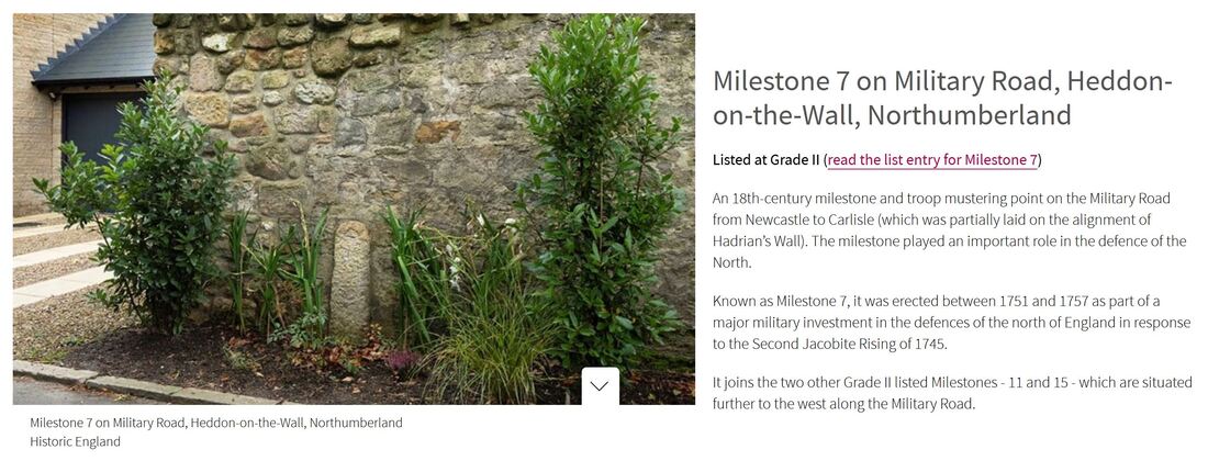
Milestone 7 for listed status

1/11/2022

0 Comments

 
Picture
Historic England Highlights Fascinating Heritage Sites Listed in 2022 (Published 15 December 2022). .
Picture
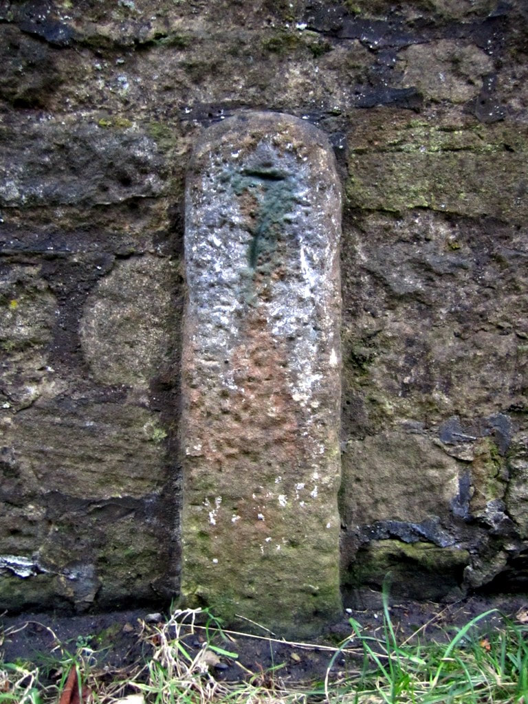
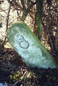
Milestone 7 by Old Military Road, Heddon on the Wall. Photo A Curtis (2011).
Picture
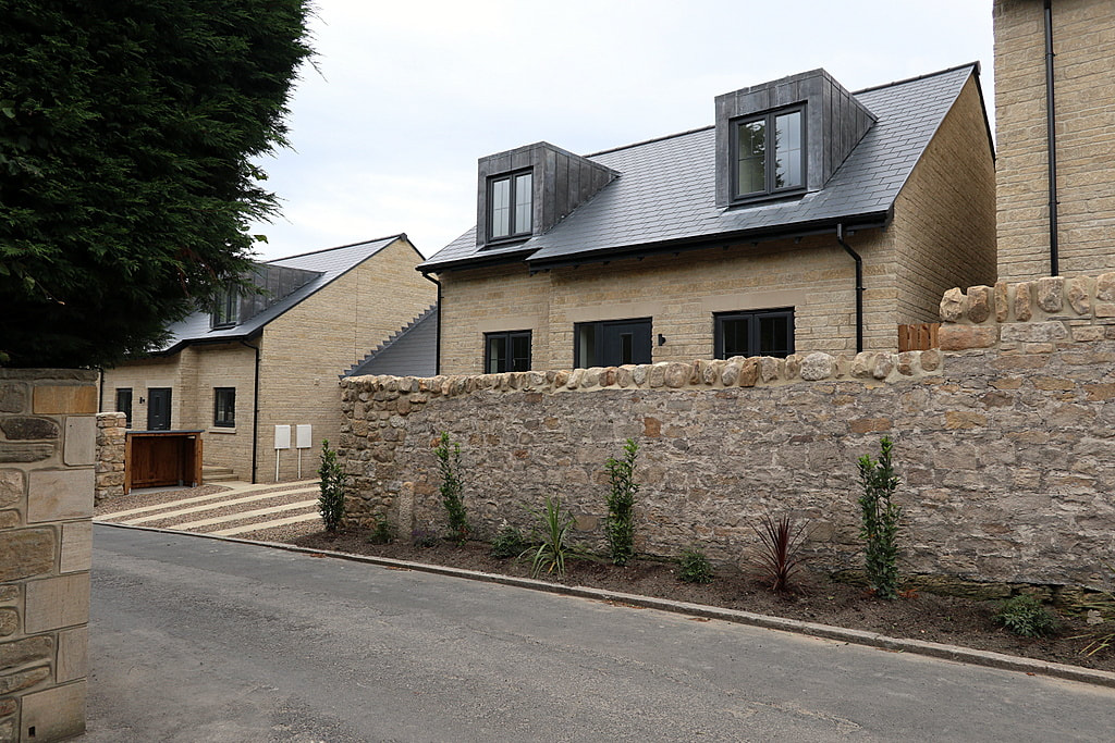
Location of Milestone 7 by wall of Tulip Mews. Photo A Curtis (2020).
Historic England List Entry 1483329
Grade II Listed on 6th December 2022

Name: Milestone 7
Location: Adjacent to the north boundary wall of Thornlea Cottage, Tulip Mews, Heddon-on-the-Wall, Northumberland, NE15 0DR.

Summary
Military milestone, erected between mid-1751 and 1758 as part of the military road linking Newcastle to Carlisle, built in response to the second Jacobite Rising of 1745.
Reasons for DesignationThis milestone erected between 1751 and 1757, is listed at Grade II for the following principal reasons:

Architectural Interest
A rare, well-preserved, early example of a milestone sited in its original location, its simplicity being characteristic of its C18 date and military origins; It remains fully legible and unusually it only shows distances from one direction i.e. from Newcastle-upon-Tyne.

Historic interest
The milestone is illustrative of a major military investment in the defences of the North of England in the mid-C18, in response to the Second Jacobite Rising of 1745.

Group value
It benefits from a strong functional, historical and spatial group value with the contemporary listed Grade II Milestones 11 and 15, which are situated further to the west along the Military Road.

History
Milestone 7 marks the distance in miles from the west gate of Newcastle upon Tyne to this point along the military road constructed between Newcastle and Carlisle from 1751 to 1757. Known as the Military Road, currently partly reused by the B6318 and the B6528, the need for it was identified by Field Marshall George Wade (1673-1748), following his failure to intercept the Jacobite army of Charles Edward Stewart (Bonnie Prince Charlie) in November 1745. Wade was at Newcastle when the Jacobites marched from Edinburgh, taking Carlisle on the 15th and moving onwards to reach Manchester by the 23rd. Meanwhile, Wade left Newcastle for Carlisle on the 16th but had been forced to halt at Hexham by poor roads and snow, returning to Newcastle by the 22nd, without ever having made contact with the Jacobites. Although the road is now often associated with him, Wade was not involved in its construction as he died in 1748.

The route of the Military Road was surveyed in 1749 and was estimated to cost in the region of £22,450. Following an Act of Parliament in 1751, construction work was contracted-out to two civilian companies, who completed the road in 1757. The first 48km follows the alignment of Hadrian's Wall, with much of the stone used for hardcore being quarried from the historic structure itself, which caused considerable disquiet among antiquarians at the time. The total cost of the road was £22,680, shared by the Cumberland and Northumberland commissioners; this figure included the purchase of land, dry stone boundary walling, stone bridges, the construction of 14 tollhouses, and erection of milestones along the length of the road, in accordance with the Act of Parliament. The original milestones were all slender stone posts and as the principal garrison was housed at Newcastle, the distances marked on them were only given from Newcastle’s west gate.

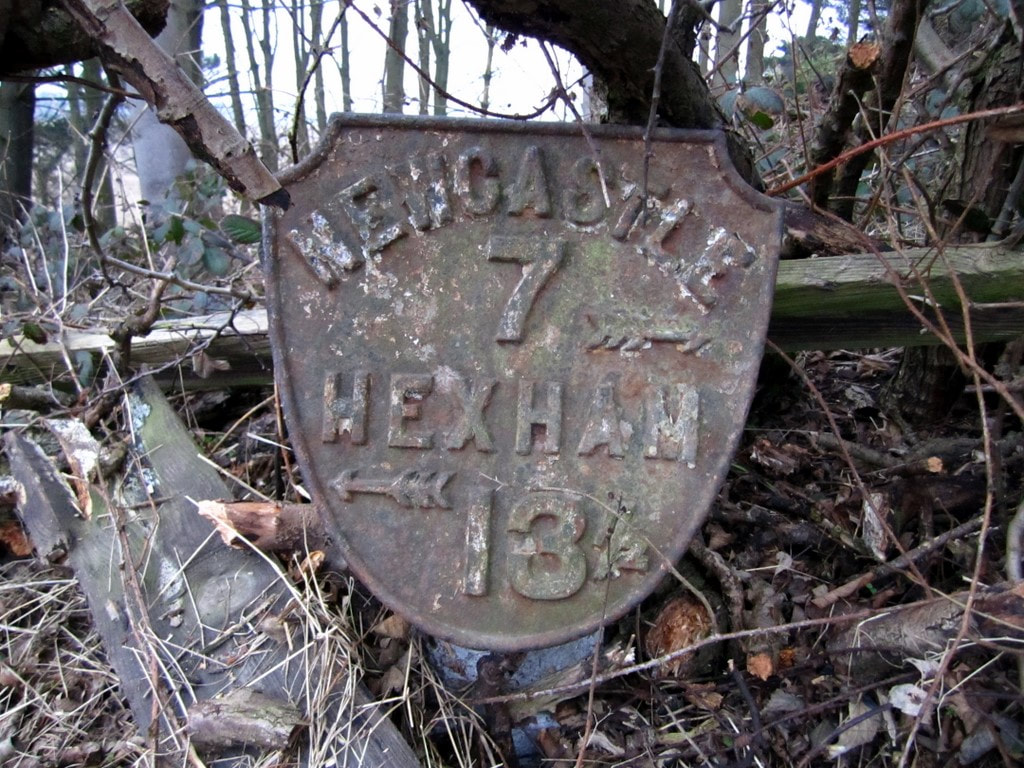
Milestone 7 is sited in its original position on the southern verge of a minor road that was once part of the main A69 between Newcastle and Hexham, until the village was by-passed in the 1970s, and this section of road was closed to through traffic. It is situated within the Hadrian's Wall World Heritage Site and lies within one of the scheduled areas for Hadrian's Wall. It is shown on the 1864 25-inch Ordnance Survey map (surveyed 1860) and is labelled as 'Old Milestone' on the 1897 edition, as it had been superseded by a metal milestone sited on the turnpiked road about 380m to the east on Great Hill, which shows seven miles from the centre of Newcastle.

DETAILS
Military milestone, erected between mid-1751 and 1758 as part of the military road linking Newcastle to Carlisle, built in response to the second Jacobite Rising of 1745.

MATERIALS
Sandstone.

DESCRIPTION
Situated on the southern verge of the Military Road, formerly part of the B6318 and at one time a section of the A69. The stone pillar stands about one metre high and has a narrow rectangular section approximately 30cm by 15cm with a chamfered rounded upper surface. The face has a roughly punched-tooled surface and is inscribed '7' , representing the distance in miles from the west gate of Newcastle upon Tyne to this point in the mid-C18. The rear of the pillar is hidden from view against a garden wall (the garden wall is excluded from the listing).

SOURCES
Books and journals
Lawson, W, 'The Origin of the Military Road from Newcastle to Carlisle' in Archaelogica
Aelianna, Vol 44, (1966), 185-207
Lawson, W, 'The Construction of the Military Road in Northumberland 1751-1757' in
Archaelogica Aelianna, Vol 1, (1973), 177-193
Websites
Heddon-on-the-Wall Local History Society - Military Road, accessed 15 August 2022 from
http://heddonhistory.weebly.com/blog/military-road
Per Lineam Valli - What is the Military Road, Mike Bishop, 2015 accessed 18 August 2022 from
https://perlineamvalli.wordpress.com/2015/06/07/69-what-is-the-military-road/
Picture
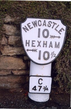
Metal shield milepost at Great Hill east of Heddon village. Photo A Curtis (2011).
Picture
Old Milepost by the B6528, Main Street, Horsley. Photo IA Davison (2000).
For those who keep their eyes open the milepost bearing the figure 8 also survives a mile west within the hedgerow alongside the road on the way to Rudchester.

Those at miles 10, 11 and 12 are also recorded but none of these are listed.

Milestone 16 (440m East of Portgate roundabout) and Milestone 19 (420m East of St Oswalds Hill Head Farm) were Grade II Listed in May 1988 (List Entries: 1303661 and 1042983).

There are a few Grade II Listed milestones attributed to the Military Road in Cumbria but they have metal plates attached to the chamfered faces of a low stone post indicating distances to both Newcastle and Carlisle and likely date to the later 1811 turnpike.
Picture
Milestone by the B6318 Military Road east of Rudchester. Photo IA Davison (2019).
LINKS

Historic England List Entry 1483329 06-Dec-2022

Historic England What's New in 2022 (Archive Link)


0 Comments

Military Road

7/3/2018

3 Comments

 
During the Jacobite uprising of 1745, the government forces based in Newcastle, under Field Marshall George Wade, were unable to cross to Carlisle in time to intercept the rebels and in fact bad weather and poor roads halted them near Hexham.
 
It was reported that departing Newcastle’s Town Moor on the 16th November, infantry only made it to Ovington by night. The roads were “terribly broken and full of ice” and men were sent out with lights and carts to bring them up, a process that went on till the march was continued next morning at nine. The first troops reached Hexham about four that afternoon, the rear at midnight, when, they could proceed no further because of the snow. They pitched camp on the south side of the union of the two Tynes and were provided with straw by the townsfolk who also kindled fires all over the ground as a protection against the severe cold. Wade waited three days for a thaw and, when none came, returned to Newcastle. He arrived on 22nd November, his army almost spent with fatigue and having failed dismally to halt the progress of the rebels.
 
One of Wade’s party, Thomas Sayer, later reported, “That he is well acquainted with the Road from Carlisle to Hexham, which is mostly through an open Country, with very few Houses, not One Part in Ten of the said Road being through inclosed Grounds: That the Country is rocky, mountainous, and boggy, and absolutely impassable, both in Summer and Winter, for heavy Carriages; and there are several Waters in the said Road, which frequently overflow and render it impassable.” The maps designated it as a ‘Summer Road’.
 
In 1749 a letter from the Duke of Northumberland with attached petition was referred to the Surveyor General. They asked “That Leave be given to bring in a Bill for laying out, making, and keeping in Repair, a Road proper for the Passage of Troops and Carriages between the said City of Carlisle and Town of Newcastle, in such Manner as to the House shall seem meet.”
Picture
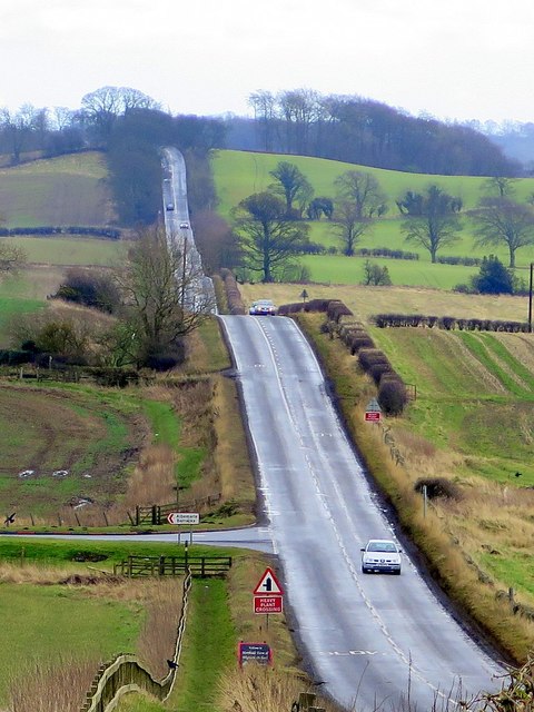
The Military Road (B6318) east of Harlow Hill. Photo A Curtis (2016).
In July to September 1749, a survey was undertaken by two military engineers, Dugal Campbell and his assistant Hugh Debbeig. Although it is often called ‘General Wade’s Military Road’, Field Marshall Wade (to give him his correct rank) in fact died in his home in Bath in 1748 and there is no evidence he had anything to do with it. It is suggested, however, that a possible instigator of the proposal, Lancelot Allgood  of Nunwick, who became Sheriff of Northumberland in 1745, may have heard, first hand, the Field Marshal’s bitter remarks about the roads over which he had just struggled to Hexham, comparing them with roads that he (Wade) had made in the Highlands some years before. Allgood became a Member of Parliament in 1749 and was actively associated not only with the Military Road but also with the Corn Road from Hexham to Alnmouth.
 
The outcome of the survey was a map measuring about ten feet six inches long by two feet wide covering five sheets joined together to make a roll. It covered an area roughly sixty miles long (i.e. from about three miles east of Newcastle to about two miles west of Carlisle) by about six miles broad at a scale of just over two inches to the mile. There are five insets all concerned with the Roman Wall and its attendant works and the course of the proposed road is shown as a dotted line co-incidental with the Wall from Newcastle to a point nearly thirty miles west. The surveyors estimated the cost of the road as £22,450.

Read More
3 Comments

    RSS Feed

    Author

    Andy Curtis

    Archives

    July 2024
    June 2024
    May 2024
    April 2024
    March 2024
    January 2024
    November 2023
    February 2023
    November 2022
    September 2022
    August 2022
    June 2022
    May 2022
    January 2022
    December 2021
    November 2021
    September 2021
    August 2021
    June 2021
    May 2021
    October 2020
    June 2020
    May 2020
    March 2020
    November 2019
    August 2019
    July 2019
    March 2019
    January 2019
    November 2018
    October 2018
    August 2018
    July 2018
    June 2018
    April 2018
    March 2018
    January 2018
    October 2017
    September 2017
    July 2017
    June 2017
    May 2017
    April 2017
    March 2017
    February 2017
    January 2017
    December 2016
    November 2016
    September 2016
    August 2016
    July 2016
    June 2016
    May 2016
    April 2016
    February 2016
    January 2016
    December 2015
    October 2015
    September 2015
    August 2015
    July 2015
    June 2015
    May 2015
    April 2015
    March 2015
    February 2015
    January 2015
    December 2014
    November 2014
    September 2014
    August 2014
    July 2014
    June 2014
    May 2014
    April 2014
    March 2014
    February 2014
    January 2014
    December 2013
    October 2013
    September 2013
    August 2013
    July 2013
    June 2013
    May 2013
    April 2013
    March 2013
    February 2013
    January 2013
    December 2012
    November 2012
    October 2012
    September 2012
    August 2012
    July 2012
    June 2012
    May 2012
    April 2012
    March 2012
    December 2011
    November 2011
    October 2011
    September 2011
    August 2011
    June 2011
    May 2011
    April 2011
    March 2011
    February 2011


    Categories

    All
    Agricultural Engineering
    Archaeology
    Barrow
    Bays Leap
    Beamish Museum
    Beer
    Beer-mat
    Bewcastle
    Books
    Border Line
    Brewery
    Brown
    Cabinetmaker
    Charlton
    Cheviots
    Churches
    Civil War
    Clennell Street
    Close House
    Coal Mining
    Cullercoats
    Cumbria
    Eachwick
    Earl Grey
    Elswick
    Family History
    Fishing
    Fishwives
    Folkestone Warren
    Forth Banks
    Furniture
    Gardens
    General
    George Clark
    Gibson
    Goods Station
    Hadrian's Wall
    Harbours
    Heddon
    Heddon Hall
    Hexham
    Hidden Chains
    Houghton
    Howick Hall
    Hunting
    Iron Sign
    Isaac Jackson
    John Grundy
    John Smith
    Knott
    Landscape
    Landslide
    Lead Works
    Lemington
    Lidar
    Lindisfarne
    Maritime
    Meetings
    Military Road
    Mill
    Monument
    Newburn
    Newcastle
    Newcastle Assizes
    News
    North Lodge
    North Shields
    Northumberland
    Northumberland Records Office
    Old Middleton
    Oral History
    Ouseburn
    Outings
    Photography
    Pit
    Place Names
    Place-names
    Ponteland
    Ports
    Postcards
    Prehistory
    Pubs
    Quarries
    Railways
    Redesdale
    River Tyne
    Rock Art
    Roman
    Sadler
    Sanderson
    Schools
    Seaton Delaval
    Ships
    Shot Tower
    Slave Trade
    Songs/Poems
    Spearman
    Stagecoach
    Stained Glass
    St. Andrews
    Stephenson
    Swann
    Tea Robbery
    Throckley
    Town Farm
    Transportation
    Trinity House
    Victorian Panorama
    Walbottle
    Walk
    Water Supply
    William Brown
    Williamson
    Woodhorn
    Ww1
    Ww2
    Wylam
    Yetholm

Powered by Create your own unique website with customizable templates.