Heddon on the Wall Local History Society is proud to be associated with the WallWatch Project set up in April 2015 to provide effective archaeological monitoring for the Hadrian's Wall World Heritage Site. We have volunteered to take on monitoring of two sections:
- Throckley Bank Top west to Town Farm in Heddon
- From Town Farm in Heddon through the village to crossing of A69 by-pass
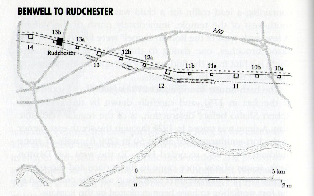
The map and brief description (below) of the Roman Wall remains in these areas are taken from:
J Collingwood Bruce's Handbook to the Roman Wall, 14th Ed. by David J Breeze (Soc. of Antiquaries of Newcastle upon Tyne, 2006) p.165-167.
J Collingwood Bruce's Handbook to the Roman Wall, 14th Ed. by David J Breeze (Soc. of Antiquaries of Newcastle upon Tyne, 2006) p.165-167.
Throckley and District Bank Top Club is the computed site of MC11 (Throckley Bank Top) but investigations on three occassions have failed to locate it and it may have been destroyed. In 2002 a metalled surface of two levels was recorded north of the presumed site of the milecastle. Near this point a hoard of over 5,000 silvered coins of 244-75 was found in 1879 secreted in a pot just behind the Wall and below the main road. Further west, the Wall was recorded as 2.59m (8ft 6in) thick with a clay core. From just east of the presumed site of MC11 to T11b, 145 pits were traced along the berm for a distance of over 1 km (2/3 mile) in 2002. Some pits retained the impressions of two upright stakes.
T11a (Heddon Hall) has not been found. At the end of the houses on the right the ditch starts to become visible; to the left there are faint traces of the Vallum. T11b (Great Hill) lies on the east side and towards the summit of Great Hill, its location only surmised in 1928 by the discovery of pottery and 'occupation earth'. The line of the pits planned in 2002 turned towards the Wall at this point, suggesting that the berm narrowed at the turret. The Broad Wall was removed from here in 1926: it was found to have been bonded with tough white mortar. The Vallum was examined in 1893 when the toolmarks of the Roman diggers were recognised on the south side of the ditch, both sides of which were revetted with masonry between the out-cropping bed rock. There is no marginal mound on the south berm. The Vallum changes direction on top of the hill, but the Wall turns further west on the downhill slope , within the English Heritage enclosure to the south of the modern road. At this point, the north mound of the Vallum is only 20m (66ft) behind the Wall.
Within the English Heritage enclosure a stretch of Broad Wall stands up to 1.52m (5ft) high. Some of the stones of the south face, which survives up to seven courses high, retain traces of white mortar, which is usually assigned to the Severan period. Insufficient remains, however, to prove that these represent more than over-pointing of the joints, or even a surviving indication of where the masons mixed their mortar beside the Wall. The foundations are 3.23m (10ft 7in) wide and the Wall is 2.92m (9ft 7in) thick; its core was of clay before consolidation. At the west end of the stretch a kiln was later built into the back of the Wall. Also, at the west end, the south lip of the ditch survives.
MC12 (Heddon) lay under Town Farm; its north gate is recorded as having been found in 1926. A large hoard of Roman coins in wooden boxes was found here in 1752. Another small hoard discovered at or near Heddon about 1820 comprised coins of emperors from Maximian (286-305) to Arcadius (383-408), the latest being one of 394. Finally, two inscriptions were discovered during the construction of the Military Road, and are presumed to have come from the Heddon area. Both record the Sixth Legion engaged on rebuilding work (Leg VI V P F ref), and one bears the names of Tertullus and Sacerdos, consuls for 158. The Military Way was found to lie on the north mound of the Vallum just west of Heddon.
From Heddon the Wall follows the B6318, the Military Road, westwards. The road lies on the line of the Wall with the ditch to the right, which was found in 1956 to be 8.23m (27ft) wide and 2.13m (7ft) deep, with an upcast mound 9m (30ft) wide. South of the road, the south mound of the Vallum is visible behind the houses as a ridge, having a commanding view to the north.
T12a (Heddon West) was examined in 1930. It was so badly robbed that the existence of an internal platform could not be determined. Its mortared walls were 1.22m (4ft) thick, and the door lay to the east. T12b (North Lodge), excavated the same year, was the same plan as its neighbour, though here the platform survived. At this point the B6318 diverges from the Wall line to cross the dual carriageway. Sections cut here in 1975 showed the Wall to be standing up to five courses high with a sandy clay core and resting upon a foundation of similar material 76cm (2ft 6in) deep. The culvert carrying the Rudchester Burn under the Wall was seen in 1974: it was similar to that recorded by Bruce at West Denton Burn.
Links
Heritage crime concern on Hadrian's Wall because of illegal digging - ChronicleLive, 10 February 2015
Local people needed to play key role in monitoring Hadrian’s Wall World Heritage Site - Tyne & Wear Museums
Volunteers sought to monitor Wall - Hexham Courant, 7 April 2015
Review of the 2008 –2014 Management Plan (June 2014)
Hadrian's Wall Community Champions on Facebook
Local people needed to play key role in monitoring Hadrian’s Wall World Heritage Site - Tyne & Wear Museums
Volunteers sought to monitor Wall - Hexham Courant, 7 April 2015
Review of the 2008 –2014 Management Plan (June 2014)
Hadrian's Wall Community Champions on Facebook


