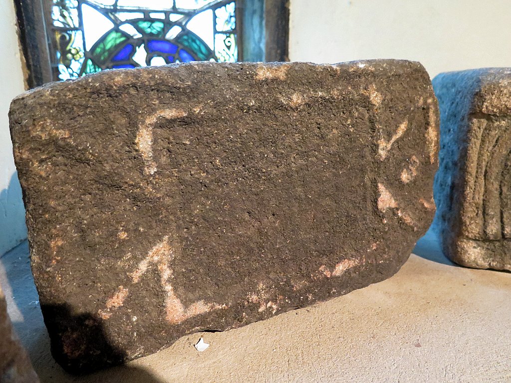
Heddon-on-the-Wall Local History Society
  • Home
  • Site search
  • Calendar
  • Introduction
  • Where are we?
  • History Map
  • Timeline
    • Prehistoric
    • AD43 to 1599
    • 1600 to 1799
    • 1800 to 1899
    • 1900 to 1999
    • 2000 to 2099
  • Heddon's History
    • Prehistory
    • Hadrian's Wall >
      • Vallum excavation (1893)
      • Hadrian's Wall excavation 1926
      • Wall ditch, Bays Leap (1958)
      • Hadrian’s Wall: Archaeological research by English Heritage 1976-2000
      • Throckley & Heddon entanglements
      • WallWatch
      • English Heritage (2020)
      • Wardell-Armstrong Archaeolgy Reports
      • Historic England Archives
    • Six townships >
      • 1 Heddon township >
        • Heddon in the Middle Ages
        • Common Land
        • Middle Marches
        • Tithe Award
        • St Andrew's Church >
          • Stained Glass Windows
          • Churchyard
          • Monuments of church & churchyard (1991)
          • Monuments Page 2
          • Vicars of Heddon
        • Village property
        • Heddon Hall >
          • Sale of Heddon Hall 2012
        • Heddon Banks Farm
        • Frenchman's Row
        • Methodist Church >
          • Heddon Methodist Church Centenary 1877-1977
        • Men's Institute
        • Women's Institute
        • Welfare Field
        • Knott Memorial Hall
        • Memorial Park
        • Schools
        • River Tyne
        • Coal Mining
        • Quarrying
        • Water Supplies
        • Transport
        • Waggonway & Railway
        • Occupations from 1800
        • Miscellaneous
      • 2 West Heddon township
      • 3 East Heddon township
      • 4 Houghton & Close House township >
        • Close House
      • 5 Eachwick township
      • 6 Whitchester township
    • Rudchester
  • People
    • Sir James Knott
    • Cadwallader J. Bates
    • Richard Burdon
    • Hugh Sinclair (Tim) Swann
    • George Clark
  • Old Photos
    • Postcards
    • Old photos 1
    • Old photos 2
    • Old photos 3
    • Old photos 4
    • Old photos 5
    • Old photos 6
    • Old Photos 7
  • Old News
    • Community News
    • Letter from the Emigrant Clergy of Frenchman's Row (1802)
    • Alleged Brutal Murder at Heddon-on-the-Wall (1876)
    • Sad boat accident at Ryton (1877)
    • Coronation tree (1902)
    • 65 Years on a Ferry Boat (1929)
    • Come claim your kiss at Heddon (1953)
    • The Swan (1972)
    • Heddon WI (1987)
    • Church House (1966)
    • Happy return (1993)
    • Hexham Courant (1997)
    • Butterfly Garden (1999)
    • Foot & Mouth (2001)
    • Remembrance Day (1996)
    • Remembrance Day (2016)
    • RAF at Ouston (2007)
    • Close House Golf Course (2009)
    • Heddon pupils celebrate British heritage (2011)
    • Roman Wall Forge (2011)
    • Diamond Jubilee (2012)
    • Auction of Bronze Statue, Close House (2012)
    • Heddon WI (2012)
    • Puffing Billy Festival (2013)
    • Heddon Village Show (2014)
    • View of the North (2014)
    • The Wall at Heddon (2014)
    • Heddon Village Show (2015)
    • War veterans singing send-off (September 2015)
    • Anglo-Saxon history (2014)
    • Heddon WI at 100 (2017)
    • Hadrian's Wall discovery (2019)
    • Tulip Mews (2020)
    • Mike Furlonger
    • Hadrian's Wall 1900 Festival
  • Memories
    • Olive White
    • Betty Cockburn
    • Betty Cockburn - miscellaneous information
    • Isabel Snowdon
    • William & Winnie Watson
    • Edith Ward
    • Mark Parker
    • Jack Lawson
    • Winnie Spoor
    • P Reay
    • Mr and Mrs Hall
    • Peter Chapman
    • Elizabeth Elenora Eames
    • Harry Murray
  • Other documents
    • Mackenzie (1825)
    • Bates (1886) >
      • Early & Roman
      • Townships
      • Heddon Church
      • Heddon & Houghton
      • Whitchester
      • Eachwick
      • West & East Heddon
      • Records
      • Addenda
      • Appendix A
    • History, Topography & Directory of Northumberland (Bulmer's) - 1886
    • History of Northumberland (1930)
    • Collingwood Bruce (1853)
    • Whellan (1855)
    • Post Office Directory (1879)
    • Prominent people in Heddon
    • Place names
    • Ad Murum
    • Archived documents
    • Thomas Bewick's History of British Birds (1826)
    • Census data 1801-1991
    • Historical Records 1888-1890
    • Knott Sale of Village Property (1924)
    • Extracts from Parish Council Records
    • Local colliery records
    • Blackburn (1938)
    • Clark (c.1963)
    • History of Church (1968)
    • Boundary Commission Report 1984
    • Village Atlas 2022
  • Walks
    • Walks 2
  • Blog
  • Contact us
  • Links
  • What's new
  • Past & Present
  • Photo of the Month
  • Place Name Studies
    • Meas & Meres
    • OS Name Books: Elsdon
    • OS Name Books: Allendale
    • OS Name Books: Cheviot Hills
    • OS Name Books: Other Parishes
  • Heddon 3D landscape

Barcombe Hill above Vindolanda Roman Fort

22/2/2026

0 Comments

 
Iron Age hillfort & Roman Signal Station on Barcombe Hill above Vindolanda Roman Fort, Northumberland.

Location: 
NY 7830 6681

Keys to the Past: N6569


Scheduled Monument: 1018536
Picture
LIDAR (DSM, 1m) copyright Environment Agency (2022) - enhanced for archaeology.
Picture
View of Vindolanda Roman Fort from Roman Signal Station on Barcombe Hill. 3D model from lidar data.
3D LiDAR landscape on Sketchfab: https://skfb.ly/pGKN9
Picture
Site of Roman Signal Station, Barcombe The ditch here, parallel with the escarpment edge, is the north side of a prehistoric defended settlement, thought to be Iron Age in date, probably extended by later Roman quarrying for stone. Within the enclosure, the Romans constructed a Signal Station providing inter-visibility north to Hadrian's Wall and west to Vindolanda Fort NY7866 : View west from site of Roman Signal Station, Barcombe. However, excavation showed that it may have only been in use for a short period during the later first century AD. LinkExternal link (Archive LinkExternal link ) A rectangular ditch with rounded corners around the mound in the north-west part of the larger enclosure is clearly visible in aerial views. Photo A Curtis (2012).
Picture
View west from site of Roman Signal Station, Barcombe Hill. Barcombe Hill trig point is on the extreme left, Long Stone on the peak just left of centre. Although a misty day, Vindolanda Roman Fort can just be made out in the valley, right of centre, with the straight line of the Stanegate Roman Road climbing the ridge to its right. The Signal Station would have provided good views north to Hadrian's Wall including Housesteads Roman Fort to the north-east. Photo A Curtis (2012).
0 Comments

Risingham Roman Fort (Habitancum), West Woodburn

15/2/2026

0 Comments

 
Picture
LIDAR (DSM, 1m) copyright Environment Agency (2022) - enhanced for archaeology.
Risingham Roman Fort (Habitancum), West Woodburn, Northumberland.

Great weather for a site visit yesterday and, unusually for me, spent some of it with the Romans.

3D lidar landscape: https://skfb.ly/p9Cpu

Habitancum Roman Fort & Medieval Settlement is a Scheduled Monument protected by law:
https://historicengland.org.uk/.../the.../list-entry/1008561

0 Comments

Devil's Causeway, Bolam

12/2/2026

0 Comments

 
Devil's Causeway, Bolam, Northumberland.

A nice section of the now unused Roman Road passing close by the Bronze Age tumulus & standing stone known as The Poind and His Man.

https://en.wikipedia.org/wiki/Devil%27s_Causeway

Photos: Andy Curtis (2014): https://www.geograph.org.uk/photo/4226462
Picture
LIDAR (DSM, 1m) copyright Environment Agency (2022) - enhanced for archaeology.
0 Comments

Roman Forts at Low Learchild

12/2/2026

0 Comments

 
Picture
LIDAR (DTM, 1m) copyright Environment Agency (2022) - enhanced for archaeology.
The Roman Forts at Low Learchild, Northumberland, UK.
Just visible as shadows at the centre of this LIDAR image (DTM, 1m). Learchild Roman fort is believed to have had the place name ALAVNA.

The site at Learchild is a Scheduled Monument protected by law.
https://historicengland.org.uk/.../the.../list-entry/1006440

The two forts have been almost completely reduced by ploughing and forestry, and cut by a bridleway and now disused railway.

Lots more information and geophysical survey here: https://romanroads.org/reports/low_learchild_smx006_final.pdf
0 Comments

Aqueduct to Great Chesters (Aesica) Roman Fort

11/2/2026

0 Comments

 
Looking at the lidar evidence for the course of the aqueduct which led water some 10km from the Caw Burn to Great Chesters (Aesica) Roman Fort on Hadrian's Wall. Although shown in full on the OS map, several parts are missing (perhaps never completed or damaged by later drainage and agriculture). Its course over valleys assumed to have been on wooden or stone bridges. The elevation profile (created in QGIS from the DTM) shows a fall of only 10-12m over the whole length. The LIDAR view is DSM, 1m copyright Environment Agency. Contours (at interval of 1m) were created in QGIS from DTM.

The Roman aqueduct to Great Chesters from the Caw Burn is a Scheduled Monument (https://historicengland.org.uk/.../the.../list-entry/1003788)

3D LIDAR landscape: https://skfb.ly/pxqDN
0 Comments

Maiden Way, Culgaith, Cumbria

11/2/2026

0 Comments

 
Picture
LIDAR (DSM, 1m) copyright Environment Agency (2022) - enhanced for archaeology.
LIDAR suggests new line for the Roman Road, Maiden Way, through the parish of Culgaith, Cumbria, crossing the Kirkland Beck just east of the village.

Maiden Way (Roman Road) - 3D LIDAR landscape:
https://skfb.ly/pxoVw

0 Comments

Corbridge Roman Town

11/2/2026

0 Comments

 
Corbridge Roman Town, Northumberland.

The remains at Corbridge are largely those of a Roman town, 2½ miles south of Hadrian's Wall, which developed after AD 160 around a base for legionary soldiers. This replaced a succession of forts on the site, built from about AD 85 where one of the main routes northwards crossed the River Tyne. Corbridge became one of only two substantial towns in the Hadrian's Wall zone and remained a vibrant urban community until the last days of Roman Britain.

English Heritage: https://www.english-heritage.org.uk/.../corbridge-roman...
0 Comments

Hadrian's Wall, Wallhouses

10/2/2026

0 Comments

 
Hadrian's Wall at Wallhouses, Northumberland - 'slighting' of the Vallum.

One thing I like about looking at the LIDAR images is that they remind you about things I have forgotten (or perhaps never knew).

In this sector along Hadrian's Wall for example the wall itself lies under the modern road (Military Road). The north wall ditch is often extant and, when not ploughed out, so are the impressive earthworks of the Vallum, here closely parallel to the line of the Wall and to its south. The ditch of the Vallum in my enhanced LIDAR is the dark line between the two white dashed lines of the marginal mounds. These were built from the spoil of the ditch and were continuous so why do they now appear as regular segments?

When constructed the Vallum only had very few crossing points aligned with the Wall forts. However, when Hadrian's Wall was abandoned around 140AD for a new frontier in Scotland (the Antonine Wall) there was a systemmatic slighting of the Vallum creating a large number of crossings across the ditch using soil taken from the linear mounds. 35 beaks were made every Roman mile providing an interval of crossings of around 40m. "We can surely agree that the very regularity of the action of slighting the Vallum points to the hand of the army" (Breeze 2015).

When the Romans returned to Hadrian's Wall a few years later they clearly didn't bother to fill all the gaps in the linear mounds and there seems to be conflicting evidence about whether the Vallum ditch was completely reinstated as originally built.. I wonder if the LIDAR has enough resolution to see the remains of ditch crossings?


Breeze, D. J. (2015). The Vallum of Hadrian's Wall. Archaeologia Aeliana Series 5. Vol 44, pp. 1-30.

https://doi.org/10.5284/1061298

Picture
Enhanced LIDAR (DSM, 1m) © Environment Agency (2022).
Picture
Enhanced LIDAR (DSM, 1m) © Environment Agency (2022).
0 Comments

Chew Green Roman fort and camps

4/2/2026

0 Comments

 
Picture
LIDAR (DSM, 1m) copyright Environment Agency (2022) - enhanced for archaeology.
Chew Green, Northumberland.

Roman fort, two Roman fortlets, two Roman camps, a section of Roman road (Dere Street), and a medieval settlement and chapel at Chew Green in Cheviot Hills.

Chew Green is a Scheduled Monument protected by law:
https://historicengland.org.uk/listing/the-list/list-entry/1015847
Picture
LIDAR (DSM, 1m) copyright Environment Agency (2022) - enhanced for archaeology.
Picture
Plan from Richmond, I. A. and Keeney, G. S. (1937). The Roman works at Chew Green, Coquetdalehead. Archaeologia Aeliana Series 4. Vol 14, pp. 129-150.
https://doi.org/10.5284/1059983

Supposed Roman Signal Station (or small Roman fortlet), & cross-dyke (bank and ditch crossing the ridge) close by the England-Scotland Border on Brownhart Law, N of Chew Green. The track heading north into Scotland is the line of the Roman Dere Street (later called Gamelspath). The cross-dyke is an example of numerous similar earthworks of uncertain date that may have been constructed to constrain traffic along the cross-border tracks or to act as boundaries between adjacent areas of territory.
Picture
LIDAR (DSM, 1m) copyright Environment Agency (2022) - enhanced for archaeology.
0 Comments

Roman Temporary Camp, Milestone House, Haltwhistle

3/2/2026

0 Comments

 
Picture
LIDAR (DSM, 1m) copyright Environment Agency (2022) - enhanced for archaeology.
Roman Temporary Camp at Milestone House, Haltwhistle, Northumberland.

"The camp occupies a low point between a succession of north facing limestone escarpments, and it is these which account for its irregular layout. The defences enclose an area of 7ha and are best preserved on the west side and the west end of the south side where the ramparts reach a maximum height of 1.2m above the bottom of the external ditch, which is 0.3m deep. There is no rampart visible on the north side, which is delimited by the edge of a natural crag, making a rampart superfluous. There are gateways in the central points of the south and west ramparts, each with external defence banks. A gateway on the north east side is indicated by the presence of an external defence bank, though there is now no visible trace left of the adjacent rampart in this section. A later rectangular enclosure was constructed in the south east corner; its origin and purpose are not yet fully understood. Its internal dimensions are 37m from north to south by 75m east to west. A number of small, circular earthworks occur inside and outside the camp, ranging in diameter from 4m to 10m and about 0.3m high. These structures are probably the remains of simple limekilns, known locally as `sow' kilns, used as recently as the beginning of the 20th century to produce lime for fertilizer. To the immediate north of the camp lie the remains of a stretch of the main Roman east-west road, the Stanegate. Although disturbed by later hollow ways and stone robbing, its course is clear on the ground. The road runs along the high ground in the east, and then runs just to the south of the crest of the gentle ridge occupied by the Mare and Foal standing stones (the subject of a separate scheduling) and then along the ridge itself as it runs west towards Haltwhistle Burn. The road measures on average about 8m across throughout its course. Buried ditches flank the road on either side."

Scheduled Monument protected by law: 1010932

Picture
Ordnance Survey (1:10,000) - National Library of Scotland.
0 Comments
<<Previous

    RSS Feed

    Author

    Andy Curtis

    Archives

    April 2026
    March 2026
    February 2026
    January 2026
    October 2025
    August 2025
    July 2025
    May 2025
    November 2024
    July 2024
    June 2024
    May 2024
    April 2024
    March 2024
    January 2024
    November 2023
    February 2023
    November 2022
    September 2022
    August 2022
    June 2022
    May 2022
    January 2022
    December 2021
    November 2021
    September 2021
    August 2021
    June 2021
    May 2021
    October 2020
    June 2020
    May 2020
    March 2020
    November 2019
    August 2019
    July 2019
    March 2019
    January 2019
    November 2018
    October 2018
    August 2018
    July 2018
    June 2018
    April 2018
    March 2018
    January 2018
    October 2017
    September 2017
    July 2017
    June 2017
    May 2017
    April 2017
    March 2017
    February 2017
    January 2017
    December 2016
    November 2016
    September 2016
    August 2016
    July 2016
    June 2016
    May 2016
    April 2016
    February 2016
    January 2016
    December 2015
    October 2015
    September 2015
    August 2015
    July 2015
    June 2015
    May 2015
    April 2015
    March 2015
    February 2015
    January 2015
    December 2014
    November 2014
    September 2014
    August 2014
    July 2014
    June 2014
    May 2014
    April 2014
    March 2014
    February 2014
    January 2014
    December 2013
    October 2013
    September 2013
    August 2013
    July 2013
    June 2013
    May 2013
    April 2013
    March 2013
    February 2013
    January 2013
    December 2012
    November 2012
    October 2012
    September 2012
    August 2012
    July 2012
    June 2012
    May 2012
    April 2012
    March 2012
    December 2011
    November 2011
    October 2011
    September 2011
    August 2011
    June 2011
    May 2011
    April 2011
    March 2011
    February 2011


    Categories

    All
    Aerial Photography
    Agricultural Engineering
    Archaeology
    Barrow
    Bays Leap
    Beamish Museum
    Beer
    Beer-mat
    Berwick
    Bewcastle
    Books
    Border Line
    Brewery
    Brown
    Cabinetmaker
    Castle
    Charlton
    Cheviots
    Churches
    Civil War
    Clennell Street
    Close House
    Coal Mining
    Cullercoats
    Cumbria
    Dmv
    Durham
    Eachwick
    Earl Grey
    Elswick
    Family History
    Fishing
    Fishwives
    Folkestone Warren
    Forth Banks
    Furniture
    Gardens
    General
    Geology
    George Clark
    Gibson
    Goods Station
    Hadrian's Wall
    Harbours
    Heddon
    Heddon Hall
    Hexham
    Hidden Chains
    Hillfort
    Horsley
    Houghton
    Howick Hall
    Hunting
    Iron Sign
    Isaac Jackson
    John Grundy
    John Smith
    Knott
    Landscape
    Landslide
    Lead Works
    Lemington
    Lidar
    Lindisfarne
    Maritime
    Meetings
    Military Road
    Mill
    Monument
    Newburn
    Newcastle
    Newcastle Assizes
    News
    North Lodge
    North Shields
    Northumberland
    Northumberland Records Office
    Old Middleton
    Oral History
    Ouseburn
    Outings
    Photography
    Pit
    Place Names
    Place-names
    Ponteland
    Ports
    Postcards
    Prehistory
    Pubs
    Quarries
    Railways
    Redesdale
    River Tyne
    Rman
    Rock Art
    Roman
    Sadler
    Sanderson
    Schools
    Seaton Delaval
    Ships
    Shot Tower
    Slave Trade
    Songs/Poems
    Spearman
    Stagecoach
    Stained Glass
    St. Andrews
    Stephenson
    Swann
    Tea Robbery
    Throckley
    Town Farm
    Transportation
    Trinity House
    Tyne & Wear
    Victorian Panorama
    Walbottle
    Walk
    Water Supply
    William Brown
    Williamson
    Woodhorn
    Ww1
    Ww2
    Wylam
    Yetholm

Powered by Create your own unique website with customizable templates.