
In a much earlier blog post I discussed the apparent change in the line of the England-Scotland Border in the region of Yetholm Common. Here I will add some detail about the 'common land' lost from Scotland with the straightening out of the Border Line between Humbleton Swire and Whitelaw Nick, due east of the Stob Stones.
The Rev. John Baird of Yetholm recorded in 1841:
There are nearly 6000 acres in the parish: of which more than 2600 are arable, and more than 3000 remain in permanent pasture. In addition there is a common of 200 acres, called Yetholm Common, on which the inhabitants of Kirk Yetholm have the privilege of cutting turf and grazing their cattle: it is a wild moorish piece of ground, upon the borders, claimed I believe, by both kingdoms.
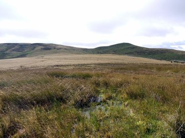
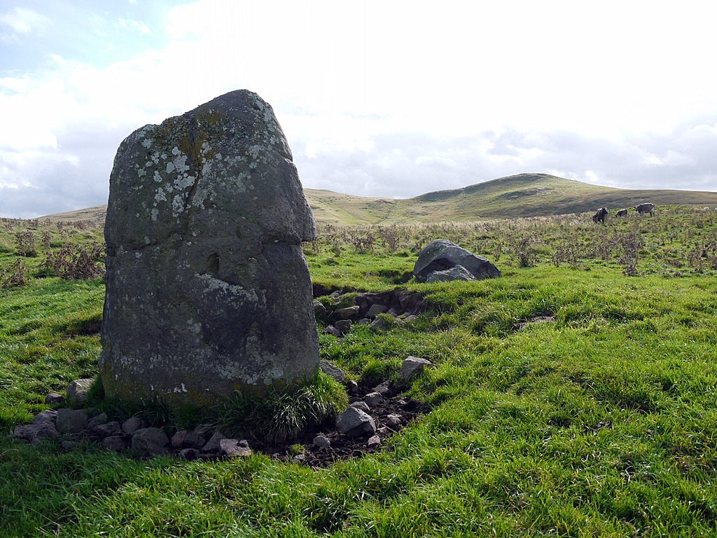
Border ridge north of Whitelaw Nick. Photo A Curtis (2012).
Rev. John Baird (1799-1861) was the minister at Kirk Yetholm. He was responsible for the new bridge, rebuilding the church and school. He also educated the Gypsies and brought them into the community. He was a founder member of the Berwickshire Naturalists Club.
A. Fullarton's The Topographical, Statistical, and Historical Gazetteer of Scotland: Vol. 2 (1848) says of Kirk Yetholm:
Yetholm common, a wild moor of considerable extent, on debateable land between Scotland and England, is claimed by villagers, and yielded to their possession for the cutting of their turf and the grazing of their cattle.
Elsewhere he states it rather doubtfully belongs to Scotland.
Probably from the same sources, John Marius Wilson (1859) in The land of Scott; or, Abbotsford, The Country of the Tweed and its Tributaries, and St. Mary's Loch describes:
A wild moor, called Yetholm Common, lying to the east, and comprising an area of several hundred acres, is claimed by the town's-people as an ultranational tract, neither in Scotland nor England, and used by them for the cutting turf and grazing cattle.
The Scottish Commons Directory records:
Yethom Common is situated just south west of Kirk Yetholm and was originally associated with the Gypsy encampment with which the village is associated. The common is well up in the hills and the position is marked by two large stones, known locally as the Stob-Stanes. Both villages in Yetholm (Town & Kirk) also feature large Greens.
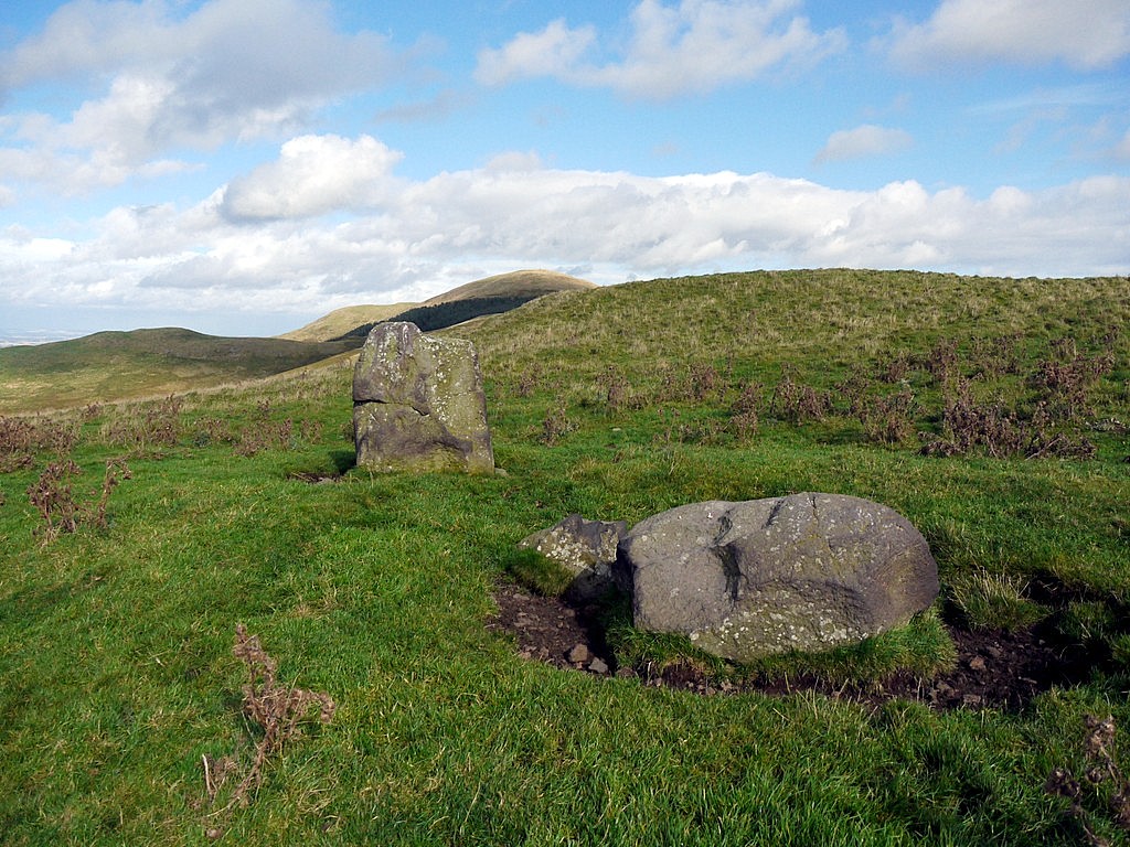
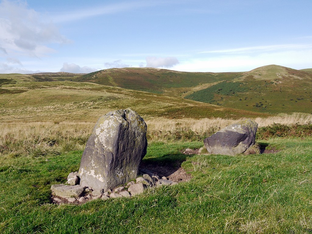
The Stob Stones are said to be known locally as the Gypsy Stobs from the tradition that the kings of the Yetholm Gypsies were crowned there. In the photo below, the location of the Stob Stones, left of the straight wall that now marks the Border, is well inside Scotland.
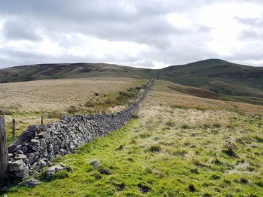
The Border Line on Stob Rig. Photo A Curtis (2012).
Logan Mack (1924) in The Border Line suggested that the eastern part of the Border, from Berwick to where the Redden Burn joins the River Tweed just west of Carham was the earliest settled part. It had been claimed by the Scottish King, Malcolm II after the Battle of Carham in 1018.
Although 24 English knights considered the frontier fixed west from Berwick as far as White Law in 1246, its line was not agreed by the Scottish contingent. Some of the place names along the English Line such as 'Tres Karras' and 'Hoperiglawe' cannot be identified today.
It appears that the early surveyors used the hilltops and watershed (as the water falleth) to define its course through the Cheviot Hills. One such survey took place in 1522 and is described by Logan Mack in some detail. Again many of the placenames are different from those used today.
It was clear that in several places:
.... the towns of Scotland bounding upon England have eared, ploughed and sown much of all the ground that was wont to be their pastures, and pasture all their sheep and cattle in great numbers within the realm of England.
A map of The County of Nothumberland by Charles Smith published in 1801 (below) shows several areas of disputed territory along the Border Line including one east of Yetholm, stretching from the west side of Coldsmouth Hill south to Five Stones, whereever that may be.
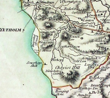
Map of The County of Northumberland by Charles Smith (1801).
Logan Mack tells us that these disputed areas were still being shown on maps as late as 1837 although information was often copied from earlier authors. He says, that if it can be assumed that the dispute ended in 1838, the course of the Border Line between the two countries as it is now defined took only 820 years to settle!
UPDATE 17th December 2017
W Ford Robertson in his book Walks from Wooler (1926) provides the following information (p.143-144) about the line of the England-Scotland Border in this location said to be from a cutting in the Westminster Gazette.
W Ford Robertson in his book Walks from Wooler (1926) provides the following information (p.143-144) about the line of the England-Scotland Border in this location said to be from a cutting in the Westminster Gazette.
... a story of how borders are made. I heard it told by an old Scottish shepherd and afterwards found the original version by Mr George Bolam. He was inspecting boundary fences in the Cheviots and found a grave discrepency between one of them and the ordnance map. The shepherd explained:-
"Oh, aye, sir, yon's the lie o' the auld stones, nae doot, but it didna suit for the tae set o' yowes to hae a' the meat [good grass], an' the tither a' the bield [shelter]; sae Edam o' Helter Burn [Adam Calder of Halter Burn] an' me made a pack an' shiftit a wee; we gie a bit here an' tak a bit there, ye see, sae naebody's the waur on't, an' the sheep's muckle the better; forby ye'll obsairve the grand grip yon stretching-posts hae gotton."
UPDATE 12th June 2020
The following information was provided by Ned Pegler who got in touch with me recently having found more information about Yetholm Common in his local library. His comment appears below the blog article on the Stob Stanes. We believe that the author of the unpublished work, Yetholm: Materials for a History (2007) died a few years ago. His Chapter 2 provides relevant information on the interesting history of Yetholm Common.
I remember looking for historical material of this sort at the time of writing this blog but failed to find anything. I would like to thank both Ned and Mr P. D. Wood whose interests in this area clearly follow my own but whose historical research abilities are definitely more advanced. I am pleased to be able to reproduce the historical research of P. D. Wood for a larger audience here.
UPDATE 31st October 2023
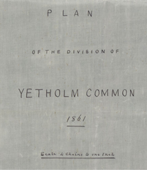
This is the Map or Plan of the tract of land called or denominated "Yetholm Common" & of the division or allocation of the same made-out & prepared by William Wightman Surveyor Wooler Northumberland under instuctions from the undersigning Thomas Scott of Graden residing at Broomhouse in Northumberland & John Thompson of Pawston in the County of Northumberland Farmer two of the Arbitrators in a Submission between the Marquis of Tweedale Baron Ossulston now Earl of Tankerville & George Burdon Esq. which Map or Plan is referred to in & is signed as relative to the Secret Arbrital in the said submission executed by the said Thomas Scott & the said John Thompson of even date with this docquet In Witness whereof the Map or Plan this docquet on the same written by William Eckford Clerk to James Tait Writer to the Signet Kelso is [?] by us the said Thomas Scott & the said John Thompson at Berwick upon Tweed the 29th day of June 1861 years before these Witnesses Thomas Cockburn Junior Wine Merchant Berwick upon Tweed & the said William Eckford (signed) Thos Scott John Thompson Signed & Published in the presence of Thos Cockburn Jr of the Town of Berwick upon Tweed Wine Merchant there Witness William Eckford of the Town of Kelso Clerk to James Tait Writer to the Signet here Witness.
Chapter 2 from Yetholm - Materials For A History by P D Wood 2007, pages 16-19.
KIRK YETHOLM COMMON
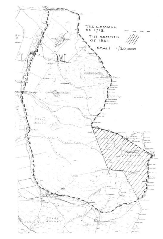
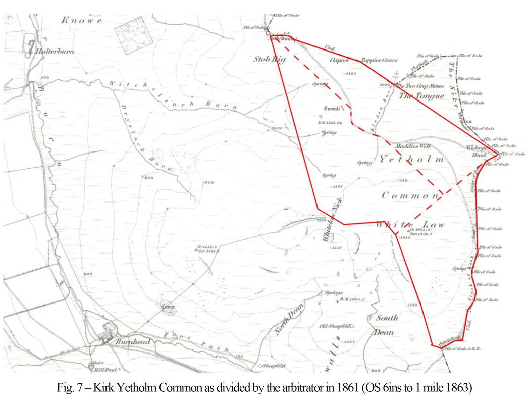
The common was an area of hill grazing lying on the English border East of Halterburn. This part of the Border had been in dispute for centuries. Twenty-four knights of Northumberland agreed in 1245-6 that the border line ran straight from Hoperiglaw to Whitelaw, much as it is today, but by the 16th century the official line ran from the Bowmont Water up the Halter Burn to the White Swire. All the ground between the burn and the modern Border then lay in England, including the township of Etter, now just a jumble of banks and ditches under the grass. The official line was still unchanged in 1604, but by 1769 it is specified as on the 1st edition Ordnance Survey maps (see Fig.7), though part of it is still noted as disputed. On today's maps it is slightly different again. The reason for all this lies far in the past.
The common was part of Colpenhope Grange, owned by Kelso Abbey in the 14th century, which in turn had been part of the lost shire of Yetholm and the Terra Lindisfarnensis in the 7th century, long before the kingdoms of England and Scotland, and the border between them, had come into existence. Most commons are survivals from the remote past, rather than improbably generous grants from lords to tenants, and this one seems to have been no exception. It had survived from a time before any border existed at all, through a time when single ownership and management still allowed occupation to be as peaceable as it ever is, to a time when divided nationality and ownership led to endless disputes.
The earliest account of problems comes in Bowes' Border Surveys of 1542 and 1550:
"... and upon the said place upon Halterburn called the Overstrawford the said march and uttermost boundary between England and Scotland stretcheth and goeth up the said runnel or water called Halterburn to the height of a hill called White Swire within which boundary the Scots have within the space of three or four years last past and yearly increasing more and more have plowed and sown within English ground along the said Halterburn almost by the space of two miles of length and as broad as the ground in that place lying along the side of a great hill will bear any corn. And the ground there plowed and sown by the Scots within the ground of England by estimation extendeth to two hundred acres and above, all the which corn growing this year upon the same sown by the Scots we likewise wasted and destroyed in our passage aforesaid.
"Also upon the said Halterburn we did perceive and see two broad ways or rakes commonly used, occupied and worn with cattle brought out of Scotland to be continually and daily pastured and fed within the ground of England.
And there is to be noted that by the laws and customs used at this present upon those marches, if any Englishman find Scottish cattle pasturing upon the ground of England and distrain them (as reason will) for damage doing there, the Scot will bill the said Englishman for taking of his cattle in a place within the realm of Scotland. And what answer soever the Englishman truly make thereunto, the proof and trial of the place where the Scot supposed his goods to be taken is always referred to other of the Scots, who by accustomed perjury recovereth the cattle again without making any amends to the hurt, loss and trouble of the Englishman".
This is of course an English complaint, at a time when the lands lay in England, but they were just as bad as the Scots.
The next account is dated 1687. For some years Sir William Bennet had been suffering English encroachments into what he regarded as his Scottish common of Kirk Yetholm, and which the Earl of Melford, in Northumberland, persisted in calling the common of Haldenrigge and Wester Staffoord. He brought an action at law and produced many witnesses whose depositions make interesting reading.
James Gladstaines in Halterburn testified that the common was always called Kirk Yetholm common, and that "Sir William Bennet and his tenants in Kirk Yetholm had pastured their goods, horse, nolt, sheep and others, had cast their feall [peat], divots and turfs, and had had their summer sheills builded upon the common these fifty years bygone peaceably without interruption".
James Burne, merchant in Yetholm, gave evidence that grazing was stented, or rationed out, and that he had grazed two nolt with William Burne [tenant in Kirk Yetholm Mains], for a payment of two shillings sterling for each. Town Yetholm tenants were debarred.
However, William Simpsone in Town Yetholm said that he had had grazing there on payment of a grass maill, so clearly outsiders were able to buy grazing from the official commoners. Simpsone tells us that the common was known as "the common betwixt England and Scotland", and mentions "the bigging of shealis in the summer tyme for the watching of their goods in the night . . . and a fauld built by them in the top of Humeltoune for keeping of their horses, and they suffered no others to pasture thereon".
This is all good evidence to support Sir William's successful action, but it also tells us that summer sheiling was carried on here into the later 17th century, rather later than is usually found.
William Bennet followed his father in 1712-13 in joining with Patrick Murray of Halterburnhead and Cherrytrees to bring another action against Lord Osswalton of the Tankerville Estate and others to stop continuing encroachment from England. Robert Burn in Kirk Yetholm told of "a sheil built for the nolt herd of Kirk Yetholm, in which he lay and watched the nolt in the night time . . . They were in use to stop and hinder the goods on the English side when they came over the Whitelaw" and numerous witnesses spoke of hounding and driving the English cattle if they passed various border landmarks, John Dubieson in Kirk Yetholm also said that the Kirk Yetholm herds "would yearly build a shiel for watching goods, and he himself had lain in one".
These are probably just night time shelters rather than true residential shiels, for the herds were barely an hour from home, but the persistence even of this into the 18th century is unusual. However, the greatest interest in this action (which Bennet also won) lies in the detailed bounds given several times in identical wording, including in the final decreet. They are as follows: (see adjacent map and Fig. 7)
KIRK YETHOLM COMMON
The common was an area of hill grazing lying on the English border East of Halterburn. This part of the Border had been in dispute for centuries. Twenty-four knights of Northumberland agreed in 1245-6 that the border line ran straight from Hoperiglaw to Whitelaw, much as it is today, but by the 16th century the official line ran from the Bowmont Water up the Halter Burn to the White Swire. All the ground between the burn and the modern Border then lay in England, including the township of Etter, now just a jumble of banks and ditches under the grass. The official line was still unchanged in 1604, but by 1769 it is specified as on the 1st edition Ordnance Survey maps (see Fig.7), though part of it is still noted as disputed. On today's maps it is slightly different again. The reason for all this lies far in the past.
The common was part of Colpenhope Grange, owned by Kelso Abbey in the 14th century, which in turn had been part of the lost shire of Yetholm and the Terra Lindisfarnensis in the 7th century, long before the kingdoms of England and Scotland, and the border between them, had come into existence. Most commons are survivals from the remote past, rather than improbably generous grants from lords to tenants, and this one seems to have been no exception. It had survived from a time before any border existed at all, through a time when single ownership and management still allowed occupation to be as peaceable as it ever is, to a time when divided nationality and ownership led to endless disputes.
The earliest account of problems comes in Bowes' Border Surveys of 1542 and 1550:
"... and upon the said place upon Halterburn called the Overstrawford the said march and uttermost boundary between England and Scotland stretcheth and goeth up the said runnel or water called Halterburn to the height of a hill called White Swire within which boundary the Scots have within the space of three or four years last past and yearly increasing more and more have plowed and sown within English ground along the said Halterburn almost by the space of two miles of length and as broad as the ground in that place lying along the side of a great hill will bear any corn. And the ground there plowed and sown by the Scots within the ground of England by estimation extendeth to two hundred acres and above, all the which corn growing this year upon the same sown by the Scots we likewise wasted and destroyed in our passage aforesaid.
"Also upon the said Halterburn we did perceive and see two broad ways or rakes commonly used, occupied and worn with cattle brought out of Scotland to be continually and daily pastured and fed within the ground of England.
And there is to be noted that by the laws and customs used at this present upon those marches, if any Englishman find Scottish cattle pasturing upon the ground of England and distrain them (as reason will) for damage doing there, the Scot will bill the said Englishman for taking of his cattle in a place within the realm of Scotland. And what answer soever the Englishman truly make thereunto, the proof and trial of the place where the Scot supposed his goods to be taken is always referred to other of the Scots, who by accustomed perjury recovereth the cattle again without making any amends to the hurt, loss and trouble of the Englishman".
This is of course an English complaint, at a time when the lands lay in England, but they were just as bad as the Scots.
The next account is dated 1687. For some years Sir William Bennet had been suffering English encroachments into what he regarded as his Scottish common of Kirk Yetholm, and which the Earl of Melford, in Northumberland, persisted in calling the common of Haldenrigge and Wester Staffoord. He brought an action at law and produced many witnesses whose depositions make interesting reading.
James Gladstaines in Halterburn testified that the common was always called Kirk Yetholm common, and that "Sir William Bennet and his tenants in Kirk Yetholm had pastured their goods, horse, nolt, sheep and others, had cast their feall [peat], divots and turfs, and had had their summer sheills builded upon the common these fifty years bygone peaceably without interruption".
James Burne, merchant in Yetholm, gave evidence that grazing was stented, or rationed out, and that he had grazed two nolt with William Burne [tenant in Kirk Yetholm Mains], for a payment of two shillings sterling for each. Town Yetholm tenants were debarred.
However, William Simpsone in Town Yetholm said that he had had grazing there on payment of a grass maill, so clearly outsiders were able to buy grazing from the official commoners. Simpsone tells us that the common was known as "the common betwixt England and Scotland", and mentions "the bigging of shealis in the summer tyme for the watching of their goods in the night . . . and a fauld built by them in the top of Humeltoune for keeping of their horses, and they suffered no others to pasture thereon".
This is all good evidence to support Sir William's successful action, but it also tells us that summer sheiling was carried on here into the later 17th century, rather later than is usually found.
William Bennet followed his father in 1712-13 in joining with Patrick Murray of Halterburnhead and Cherrytrees to bring another action against Lord Osswalton of the Tankerville Estate and others to stop continuing encroachment from England. Robert Burn in Kirk Yetholm told of "a sheil built for the nolt herd of Kirk Yetholm, in which he lay and watched the nolt in the night time . . . They were in use to stop and hinder the goods on the English side when they came over the Whitelaw" and numerous witnesses spoke of hounding and driving the English cattle if they passed various border landmarks, John Dubieson in Kirk Yetholm also said that the Kirk Yetholm herds "would yearly build a shiel for watching goods, and he himself had lain in one".
These are probably just night time shelters rather than true residential shiels, for the herds were barely an hour from home, but the persistence even of this into the 18th century is unusual. However, the greatest interest in this action (which Bennet also won) lies in the detailed bounds given several times in identical wording, including in the final decreet. They are as follows: (see adjacent map and Fig. 7)
"The bounds of the common begin at Halterburn and go down the same towards the East till you come to the Kaebburn [sc. the Sheilknowe Burn], by East the vestige of an old chapel called the Foulfald Chapple which is within the common, and from thence to the foot of the Countrup syke and so on the English side up the Countrupsyke to the vestige of a dyke that lies on the West side of a croft, and so along that dyke into the syke again and so up the syke to the vestige of an old dyke which begins at the head of the syke and goes over the top of the Hill and so forward over the vestige of an old sheile and thence to a great grey stone in the North side of the muir and so forward to the other two great grey stones and thence straight on to a highway and along the highway to the South upon the East side of the Oxpool and downward to the two grey stones lying near the syke which comes from Madies Well and from that along the vestige of an old dyke upon the foot of a piece of ground called the tongue and up a syke on the West side thereof to a place called the Wideopenhead and from there along the South side of the little Whytelaw by the vestige of an old dyke a little below the highway and thence by an old dyke that leads from the Whytelaw swyre down the syke to the Halter burn."
It is clear from this that as late as 1713 the common extended over the whole area between the Halterburn and the modem border line. The bounds follow very accurately the line of the Border as shown in Fig.7, but elsewhere enclose an area five or six times as large.
The Northumberland graziers gave not a fig for the judgments of a Scottish court. Trouble continued, and in 1753 William Nisbet, who had inherited the estate through marriage, was compelled to take further action against the Earl of Tankerville. This time, Scots cattle had been impounded by the Englishmen, and were rescued by "thirty or forty infuriated Scots in a violent and forcible manner". Nisbet admitted high words, but denied violence. The extent of the common is not clear in this case, but by the time we get to the New Statistical Account of 1835 it was much reduced, being described as about 200 acres, still in use and claimed by both kingdoms.
At last, in 1861 the lairds put their heads together. Advances in agriculture meant declining use of common land. It must still have been of benefit to the small feuars and poorer people, for fuel as well as grazing, but their voices were apt to go unheard. It was resolved to extinguish the common rights and to add the unencumbered land to the adjoining farms. An arbitrator was appointed, who divided the land between Kirk Yetholm in Scotland and the Tankerville estate and George Burdon in England. The whole common was assessed at 164 acres, of which Kirk Yetholm got 63 and the Englishmen 101, as shown in Fig.7.
The Border as shown on modem Ordnance maps follows roughly the West edge of the reduced common. Once again the land lies in England. At the present day it no longer matters — but who knows what disputes may lie in the future.
Notes
p.16 The knights of Northumberland -- Mack J.L., "The Border Line", 1926, p.12.
The township of Elter -- ibid. p.15.
Colpenhope Grange -- Liber de Kelso vol. II, pp. 287-293, 415, 457-8.
Terra Lindisfarnensis -- for a discussion and a map of the lost shire of Yetholm see Barrow J., "The Kingdom of the Scots", Arnold 1973, pp. 32-33.
For the origin of commons, see Hoskins W.G., in the foreword to "The Common Lands of England and Wales", Collins 1976.
Bowes' Border Surveys -- quoted in Mack, op. cit., pp. 15-27. Over Strawford is the upper of two fords just below the confluence of the Halter Burn and Humbleton Syke.
p.17 The action of 1687 -- GD6 / 823
The action of 1712-13 -- GD6 / 826
p.19 The action of 1753 -- GD6 / 829
The arbitration of 1861 -- NLS, MS. 14458, fo. 155-6. The map is in NLS.
Map Room, ref. 14760.
"About 200 acres" -- New Statistical Account, p. 170.
 RSS Feed
