
English Heritage: https://www.english-heritage.org.uk/.../hardknot.../history/
|
3D Lidar landscape on Sketchfab: https://skfb.ly/pKozv English Heritage: https://www.english-heritage.org.uk/.../hardknot.../history/ The three images below show contours at interval of 0.5m created in QGIS from dsm lidar.
0 Comments
There has been a bit of a dispute whether this is a Long Barrow (Neolithic Long Cairn) or just a spoil heap from a road cutting. The Lake District National Park HER states: The mound, first noted by C W Phillips and O G S Crawford in 1938 was dismissed by the RCHME around the same time as follows: "The wayfarer approaching the cross-roads nearly a mile ENE of Lowther Castle might eye suspiciously a long mound withinthe NW angle of the crossing, but would probably conclude that it is nothing more than an old spoil dump from the neighbouring road cutting". Notwithstanding this, the balance of probability appears to have fallen in favour of identification as a genuine long cairn, resulting in the site's scheduling. The most recent published description (Masters 1984) concludes with the following: "In fairness to the contra opinion expressed by the Royal Commission over forty years ago, it must be admitted that the minor road which runs along the S side of the cairn is in a cutting which gets progressively deeper from W to E. This does, of course, correspond to an increase in volume of cairn material, but in the absence of further evidence to the contrary, the balance of probability still seems to me to favour a long cairn rather than a spoil dump." https://www.heritagegateway.org.uk/Gateway/Results_Single.aspx?uid=63ad3334-1b06-498c-a67a-3b413dfc1e72&resourceID=19191 The mound is under a belt of trees on the north side of a minor road. It measures 101 metres long and orientated east-west. Its width varies from 13 to 28 metres and the height between 1.5 and 3.8 metres. Lidar clearly shows that the minor road approaching its junction with the A6 has been deepened but the gradients are not huge and one wonders why. In the absence of information from excavation I wondered if lidar could help solve the mystery. Scheduled Monument: 1012825 http://www.stone-circles.org.uk/stone/lowmoor.htm https://www.themodernantiquarian.com/site/2201/low-moor Lidar (DTM 1m) overlaid with contours at 0.5m. The road below the cairn is gently downhill from W to E and has been cut into lessening the gradient of descent (and widening the gap between the contours) before its junction with the main A6 shown on the right side. Could the mounds have originated with material supplied by the road cutting? No mound is shown here on the early OS maps. The profiles seem to suggest to me that you could easily fit the material from the cairn into the road cutting. It should be possible to estimate the volumes from a 3D model (if I knew how). The road was there in 1860 so perhaps the spoil wasn't removed very far. Perhaps most of it would be glacial till accounting for the boulders found inside. Lidar suggests both roads (old and new) approaching Lowther Castle had been graded in several more places with both cuttings and embankments. To enable further exploration of the Lowther Castle Estate I created a 3D Lidar landscape model on Sketchfab.
Today I am looking at the extensive parkland around the ruined mansion of Lowther Castle. Wikipedia: Lowther Castle Historic England Grade II Listed: 1000668 At the southern end of the estate, enhanced DTM lidar highlights two mounds (in white) surrounded by ditches (in black) located in grassland, just S of a large (perhaps recent) pond. The mounds are about 15m in diameter and about 0..5m high. They look very like Bronze Age burial mounds (tumuli or barrows). But are they a bit too neat to be prehistoric? The Historic Environment Record describes them as: "Possible ring ditches (circular or near circular ditches which may be the remains of ploughed out round barrows, round houses, or of modern features such as searchlight emplacements) of unknown date that appear as crop marks." It also provides an alternative explanation for the features as old circular coppices, apparently "shown on a map of probably 18th century date kept in the Lowther Estate Office that when Lowther Castle was rebuilt in 1809 the Landscape Architect would have been of the opinion that the older circular coppices detracted from the newly-planted avenue as it appears from the Castle window". Lake District National Park HER: 5375 There are several such circular ditched features in the northern part of the estate but they are nearly all of larger diameter and without raised central mounds. They look much more like tree planting rings than these do. The two features shown near the pond are some 2.5km SW of the ruined mansion, nowhere near planted avenues, and blocked from line of sight by much higher land. If they really appear on the 18th century map as tree rings there would be no doubt. There is no hint of rings on the 1st edition OS map (c.1860) although that map suggests the pond may have been created on a site of clay extraction used by a nearby tile works. Evidence suggests that the features have been there for some time. Perhaps, rather than for tree planting, they are just fake archaeology created as special features within the parkland. They would certainly have been visible approaching the castle on Emperor's Drive from the former lodge on the A6. On the prehistoric side of the argument, an archaeology report of part of Lowther Park by Oxford Archaeology North published in January 2005 states that "... the earliest identified activity within the vicinity of the park is from the Bronze Age: there are a pair of round cairns just south of the park Round Hill (NY 541 219)". Gajos, Hannah (2005) Lowther Deer Park, Cumbria. Archaeological Survey and Evaluation. Below lidar image (using DTM to remove trees) to compare the two mounds with several probable ditched tree-ring plantation features in the area of Lowther medieval village and the Castle Stead (Castlesteads) possible ring-work situated just north of the ruined mansion of Lowther Castle. Medieval village of LowtherIncludes St Michael's Church, Castle Stead (a possible Norman ring-work castle) and the deserted medieval village of Lowther, all situated north of Lowther Castle (the name of the ruined mansion house) above a steep bank above the River Lowther. Note that the several perfect circular ditched enclosures are likely former tree ring plantations often overlying earlier features.
The earthwork called Castle Stead is a rectangular ramparted enclosure 30m by 25m with very substantial ramparts 4-5m thick standing to 3m in height. The rampart is much thicker in the SE corner, possibly being the location of a tower. There are two possible entrances, one in the south and the other in the east. The predominantly earthwork form of the structure, the paucity of collapsed masonry and the possible twelfth century date would suggest that this was not a peel towe and is too small to have been a motte and bailey, but could have been a timber ringwork castle. "The ancient village of Lowther was heretofor considerable, consisting of the hall, the church, the parsonage house, and seventeen tenements, messuages, and cottages, all of which were purchased by Sir John Lowther, in the year 1682, and pulled down to enlarge his demesne and open the prospect of his house, for they stood just in front of it’. Wikipedia:Castle Stead Gatehouse - Castle Stead, Lowther Lancaster University: Lowther Medieval Castle and Village Castle Studies Trust - Geophysical survey and excavation (2023) 3D Lidar landscape on Sketchfab: DTM: https://skfb.ly/pK9Ls DSM: https://skfb.ly/pK9KR Extensive field system and settlement by Kirkland Beck, Culgaith, Cumbria shows up strongly on enhanced DSM LIDAR.
Historic England only refer to the site as: "Walls and possible structures of uncertain date." LIDAR suggests new line for the Roman Road, Maiden Way, through the parish of Culgaith, Cumbria, crossing the Kirkland Beck just east of the village.
Maiden Way (Roman Road) - 3D LIDAR landscape: https://skfb.ly/pxoVw Birdoswald Roman Fort (Banna), Cumbria.
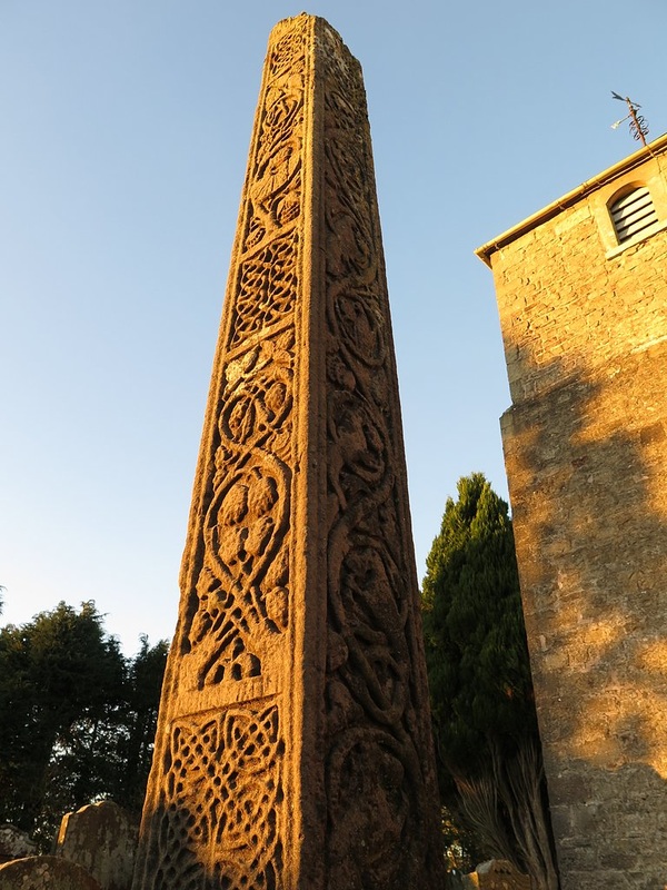
Location: NY 6155 6626 . 3D LIDAR landscape on Sketchfab: https://skfb.ly/pCVRn Historic England: https://www.english-heritage.org.uk/visit/places/birdoswald-roman-fort-hadrians-wall/history-and-stories/ Bewcastle Cross stands in the graveyard of St Cuthbert's Church, close to its south porch in the small village of Bewcastle in Cumbria. The tapered yellow sandstone shaft stands 14 feet 6 inches (4.4m) high and has lost its original cross-head. The four faces of the pillar are elaborately decorated and also carry runic inscriptions on three of the four sides.
The date of the cross and the translation of its runes have always been controversial. However, it is generally believed to date to the late 7th or early 8th century and may commemorate the early Anglo-Saxon kings of Northumbria. F M Stenton in Anglo-Saxon England (1974) says the cross commemorated Alhlfrith, son of Oswiu, and his wife, Cyneburg, daughter of Penda. Some scholars have suggested care should be taken as the evidence is unreliable and changes may have been effected by over-ambitious cleaning of the stone in the mid-19th century, and erroneous or deliberate re-cutting of the inscriptions. Essay 5, The Bewcastle Cross in Runes and Runic Inscriptions: Collected Essays on Anglo-Saxon and Viking Runes by Raymond Ian Page & David Parsons, Boydell & Brewer Ltd, 1995. It is often twinned stylistically with the Ruthwell Cross in Dumfriesshire, now preserved inside Ruthwell Church. This is carved in a very similar style and carries both Latin and runic inscriptions. |
AuthorAndy Curtis Archives
June 2026
Categories
All
|


RSS Feed
