Heddon-on-the-Wall Local History Society
  • Home
  • Calendar
  • Introduction
  • Where are we?
  • History Map
  • Timeline
    • Prehistoric
    • AD43 to 1599
    • 1600 to 1799
    • 1800 to 1899
    • 1900 to 1999
    • 2000 to 2099
  • Heddon's History
    • Prehistory
    • Hadrian's Wall >
      • Vallum excavation (1893)
      • Hadrian's Wall excavation 1926
      • Wall ditch, Bays Leap (1958)
      • Hadrian’s Wall: Archaeological research by English Heritage 1976-2000
      • Throckley & Heddon entanglements
      • WallWatch
      • English Heritage (2020)
      • Wardell-Armstrong Archaeolgy Reports
      • Historic England Archives
    • Six townships >
      • 1 Heddon township >
        • Heddon in the Middle Ages
        • Common Land
        • Middle Marches
        • Tithe Award
        • St Andrew's Church >
          • Stained Glass Windows
          • Churchyard
          • Monuments of church & churchyard (1991)
          • Monuments Page 2
          • Vicars of Heddon
        • Village property
        • Heddon Hall >
          • Sale of Heddon Hall 2012
        • Heddon Banks Farm
        • Frenchman's Row
        • Methodist Church >
          • Heddon Methodist Church Centenary 1877-1977
        • Men's Institute
        • Women's Institute
        • Welfare Field
        • Knott Memorial Hall
        • Memorial Park
        • Schools
        • River Tyne
        • Coal Mining
        • Quarrying
        • Water Supplies
        • Transport
        • Waggonway & Railway
        • Occupations from 1800
        • Miscellaneous
      • 2 West Heddon township
      • 3 East Heddon township
      • 4 Houghton & Close House township >
        • Close House
      • 5 Eachwick township
      • 6 Whitchester township
    • Rudchester
  • People
    • Sir James Knott
    • Cadwallader J. Bates
    • Richard Burdon
    • Hugh Sinclair (Tim) Swann
    • George Clark
  • Old Photos
    • Postcards
    • Old photos 1
    • Old photos 2
    • Old photos 3
    • Old photos 4
    • Old photos 5
    • Old photos 6
    • Old Photos 7
  • Old News
    • Community News
    • Letter from the Emigrant Clergy of Frenchman's Row (1802)
    • Alleged Brutal Murder at Heddon-on-the-Wall (1876)
    • Sad boat accident at Ryton (1877)
    • Coronation tree (1902)
    • 65 Years on a Ferry Boat (1929)
    • Come claim your kiss at Heddon (1953)
    • The Swan (1972)
    • Heddon WI (1987)
    • Church House (1966)
    • Happy return (1993)
    • Hexham Courant (1997)
    • Butterfly Garden (1999)
    • Foot & Mouth (2001)
    • Remembrance Day (1996)
    • Remembrance Day (2016)
    • RAF at Ouston (2007)
    • Close House Golf Course (2009)
    • Heddon pupils celebrate British heritage (2011)
    • Roman Wall Forge (2011)
    • Diamond Jubilee (2012)
    • Auction of Bronze Statue, Close House (2012)
    • Heddon WI (2012)
    • Puffing Billy Festival (2013)
    • Heddon Village Show (2014)
    • View of the North (2014)
    • The Wall at Heddon (2014)
    • Heddon Village Show (2015)
    • War veterans singing send-off (September 2015)
    • Anglo-Saxon history (2014)
    • Heddon WI at 100 (2017)
    • Hadrian's Wall discovery (2019)
    • Tulip Mews (2020)
    • Mike Furlonger
    • Hadrian's Wall 1900 Festival
  • Memories
    • Olive White
    • Betty Cockburn
    • Betty Cockburn - miscellaneous information
    • Isabel Snowdon
    • William & Winnie Watson
    • Edith Ward
    • Mark Parker
    • Jack Lawson
    • Winnie Spoor
    • P Reay
    • Mr and Mrs Hall
    • Peter Chapman
    • Elizabeth Elenora Eames
    • Harry Murray
  • Other documents
    • Mackenzie (1825)
    • Bates (1886) >
      • Early & Roman
      • Townships
      • Heddon Church
      • Heddon & Houghton
      • Whitchester
      • Eachwick
      • West & East Heddon
      • Records
      • Addenda
      • Appendix A
    • History, Topography & Directory of Northumberland (Bulmer's) - 1886
    • History of Northumberland (1930)
    • Collingwood Bruce (1853)
    • Whellan (1855)
    • Post Office Directory (1879)
    • Prominent people in Heddon
    • Place names
    • Ad Murum
    • Archived documents
    • Thomas Bewick's History of British Birds (1826)
    • Census data 1801-1991
    • Historical Records 1888-1890
    • Knott Sale of Village Property (1924)
    • Extracts from Parish Council Records
    • Local colliery records
    • Blackburn (1938)
    • Clark (c.1963)
    • History of Church (1968)
    • Boundary Commission Report 1984
    • Village Atlas 2022
  • Walks
    • Walks 2
  • Blog
  • Contact us
  • Links
  • What's new
  • Site search
  • Past & Present
  • Photo of the Month
  • Place Name Studies
    • Meas & Meres
    • OS Name Books: Elsdon
    • OS Name Books: Allendale
    • OS Name Books: Cheviot Hills
    • OS Name Books: Other Parishes
  • Heddon 3D landscape

Milestone 7 for listed status

1/11/2022

0 Comments

 
Picture
Historic England Highlights Fascinating Heritage Sites Listed in 2022 (Published 15 December 2022). .
Picture
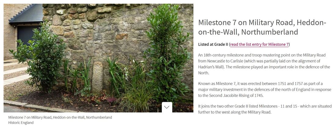
Milestone 7 by Old Military Road, Heddon on the Wall. Photo A Curtis (2011).
Picture
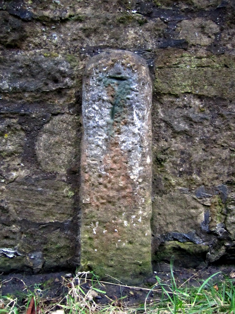
Location of Milestone 7 by wall of Tulip Mews. Photo A Curtis (2020).
Historic England List Entry 1483329
Grade II Listed on 6th December 2022

Name: Milestone 7
Location: Adjacent to the north boundary wall of Thornlea Cottage, Tulip Mews, Heddon-on-the-Wall, Northumberland, NE15 0DR.

Summary
Military milestone, erected between mid-1751 and 1758 as part of the military road linking Newcastle to Carlisle, built in response to the second Jacobite Rising of 1745.
Reasons for DesignationThis milestone erected between 1751 and 1757, is listed at Grade II for the following principal reasons:

Architectural Interest
A rare, well-preserved, early example of a milestone sited in its original location, its simplicity being characteristic of its C18 date and military origins; It remains fully legible and unusually it only shows distances from one direction i.e. from Newcastle-upon-Tyne.

Historic interest
The milestone is illustrative of a major military investment in the defences of the North of England in the mid-C18, in response to the Second Jacobite Rising of 1745.

Group value
It benefits from a strong functional, historical and spatial group value with the contemporary listed Grade II Milestones 11 and 15, which are situated further to the west along the Military Road.

History
Milestone 7 marks the distance in miles from the west gate of Newcastle upon Tyne to this point along the military road constructed between Newcastle and Carlisle from 1751 to 1757. Known as the Military Road, currently partly reused by the B6318 and the B6528, the need for it was identified by Field Marshall George Wade (1673-1748), following his failure to intercept the Jacobite army of Charles Edward Stewart (Bonnie Prince Charlie) in November 1745. Wade was at Newcastle when the Jacobites marched from Edinburgh, taking Carlisle on the 15th and moving onwards to reach Manchester by the 23rd. Meanwhile, Wade left Newcastle for Carlisle on the 16th but had been forced to halt at Hexham by poor roads and snow, returning to Newcastle by the 22nd, without ever having made contact with the Jacobites. Although the road is now often associated with him, Wade was not involved in its construction as he died in 1748.

The route of the Military Road was surveyed in 1749 and was estimated to cost in the region of £22,450. Following an Act of Parliament in 1751, construction work was contracted-out to two civilian companies, who completed the road in 1757. The first 48km follows the alignment of Hadrian's Wall, with much of the stone used for hardcore being quarried from the historic structure itself, which caused considerable disquiet among antiquarians at the time. The total cost of the road was £22,680, shared by the Cumberland and Northumberland commissioners; this figure included the purchase of land, dry stone boundary walling, stone bridges, the construction of 14 tollhouses, and erection of milestones along the length of the road, in accordance with the Act of Parliament. The original milestones were all slender stone posts and as the principal garrison was housed at Newcastle, the distances marked on them were only given from Newcastle’s west gate.

Milestone 7 is sited in its original position on the southern verge of a minor road that was once part of the main A69 between Newcastle and Hexham, until the village was by-passed in the 1970s, and this section of road was closed to through traffic. It is situated within the Hadrian's Wall World Heritage Site and lies within one of the scheduled areas for Hadrian's Wall. It is shown on the 1864 25-inch Ordnance Survey map (surveyed 1860) and is labelled as 'Old Milestone' on the 1897 edition, as it had been superseded by a metal milestone sited on the turnpiked road about 380m to the east on Great Hill, which shows seven miles from the centre of Newcastle.

DETAILS
Military milestone, erected between mid-1751 and 1758 as part of the military road linking Newcastle to Carlisle, built in response to the second Jacobite Rising of 1745.

MATERIALS
Sandstone.

DESCRIPTION
Situated on the southern verge of the Military Road, formerly part of the B6318 and at one time a section of the A69. The stone pillar stands about one metre high and has a narrow rectangular section approximately 30cm by 15cm with a chamfered rounded upper surface. The face has a roughly punched-tooled surface and is inscribed '7' , representing the distance in miles from the west gate of Newcastle upon Tyne to this point in the mid-C18. The rear of the pillar is hidden from view against a garden wall (the garden wall is excluded from the listing).

SOURCES
Books and journals
Lawson, W, 'The Origin of the Military Road from Newcastle to Carlisle' in Archaelogica
Aelianna, Vol 44, (1966), 185-207
Lawson, W, 'The Construction of the Military Road in Northumberland 1751-1757' in
Archaelogica Aelianna, Vol 1, (1973), 177-193
Websites
Heddon-on-the-Wall Local History Society - Military Road, accessed 15 August 2022 from
http://heddonhistory.weebly.com/blog/military-road
Per Lineam Valli - What is the Military Road, Mike Bishop, 2015 accessed 18 August 2022 from
https://perlineamvalli.wordpress.com/2015/06/07/69-what-is-the-military-road/
Picture
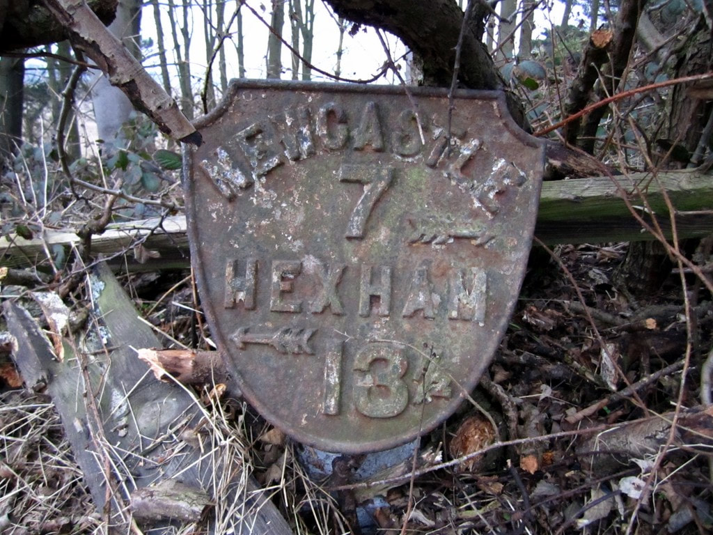
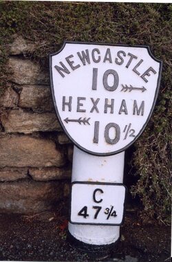
Metal shield milepost at Great Hill east of Heddon village. Photo A Curtis (2011).
Picture
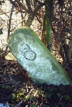
Old Milepost by the B6528, Main Street, Horsley. Photo IA Davison (2000).
For those who keep their eyes open the milepost bearing the figure 8 also survives a mile west within the hedgerow alongside the road on the way to Rudchester.

Those at miles 10, 11 and 12 are also recorded but none of these are listed.

Milestone 16 (440m East of Portgate roundabout) and Milestone 19 (420m East of St Oswalds Hill Head Farm) were Grade II Listed in May 1988 (List Entries: 1303661 and 1042983).

There are a few Grade II Listed milestones attributed to the Military Road in Cumbria but they have metal plates attached to the chamfered faces of a low stone post indicating distances to both Newcastle and Carlisle and likely date to the later 1811 turnpike.
Picture
Milestone by the B6318 Military Road east of Rudchester. Photo IA Davison (2019).
LINKS

Historic England List Entry 1483329 06-Dec-2022

Historic England What's New in 2022 (Archive Link)


0 Comments

Newcastle public transport maps 1940s

5/9/2021

5 Comments

 
Picture
Picture
I was privileged to be invited to see these two massive old maps last week. Based on sections of large scale Ordnance Survey maps, they have routes of Newcastle's buses, trams, trolley-buses and train routes painted on by hand. They had been designed to be hung up on a large wall somewhere and had been stored in a long and heavy wooden box. They had been rescued from disposal by David Vardy and brought to my attention by both Bill and Lil of Heddon who use a local Facebook page.

See below for more details and some recent research.
The origin of the box with its two maps was from a demolished property somewhere along the River Tyne, perhaps a storage warehouse of the town council.

An auction label on the wooden box showed that the maps had been in an auction by ADG Auctions of Blyth on 10th July 2021 as lot 736.

The lot was described only as 2 x 1920 local maps huge size approx. 18ft x 10ft, reused in war period 1944. Contained in large oak container.

There was no reserve price and the lot appeared to remain unsold and probably disposed of due to its condition.
The background maps can be identified as below:
  • Smaller scale: Ordnance Survey 1921 1:10,560 (6" to 1 mile) .
  • Larger scale: Ordnance Survey 1919 1:2,500 (25" to 1 mile) 
The plan based on the 6" OS Map shows the existing tram line on the Scotswood Road though Lemington and Newburn terminating at the cross roads in Throckley. The population of Newburn Urban District is given as 18,830. An existing bus route along the West Road terminates at Denton Burn but is marked as authorised but not operated further west as far as Heddon on the Wall. The population of Heddon is recorded on the plan as 676.

To the north, a bus route serves Ponteland and Darras Hall (population 1,146). The train line to Ponteland Station via Gosforth is also shown on the plan but had been closed to passenger traffic on 17 June 1929 due to competition with the buses. Ponteland remained open for goods traffic until 14 August 1967.
The larger scale map is titled:
Newcastle upon Tyne in Parliament Session 1944-45
.

​Both plans are stored in a long wooden box which appears to have come from Westminster (probably made by a company at 15 Great George Street in W1 although that is only a guess from the incompletely read labels), and addressed to The Town Clerk of Newcastle upon Tyne. It had been sent by Resident Superintendent, House of Lords in July 1946.

Both maps are massive and would require conservation if anyone wants them, as the paper maps are peeling off their backing.

A quick check of parliamentary records suggests they could have been something to do with proposed Newcastle trolley-bus routes.
Entry in Journal [15th May, 1945] read: —Bill "to confirm, a Provisional Order made by the Minister of War Transport under the Newcastle-upon-Tyne (General Powers) Act, 1935, relating to Newcastle-upon-Tyne Trolley Vehicles," read the First and Second time, and (the Bill having been reported and considered in the last Parliament) ordered to be read the Third time To-morrow.
Trolleybuses to Replace Newcastle's Trams
The Commercial Motor 7th December 1945, Page 29 
Picture
So soon as opportunity occurs, the Corporation of Newcastle-upon-Tyne has decided that its trams shall be displaced by trolleybuses. At present, the rolling-stock operated by the transport department, of which the general manager is Mr. H. C. Godsmark, A.M.I.A.E., M.Inst.T., comprises 511 vehicles, of which no fewer than 223 are trams, so that the change-over, when it can be arranged, will be no mean feat. Apart from the trams, there are 136 trolleybuses and 122 motorbuses. The remaining 30 vehicles are miscellaneous, in kind and in the purposes for which they are used.

The combined services, as they exist at present, are excellent, considering the conditions brought about by the war. Mr. Godsmark, like everyone else in a similar position, suffers from a shortage of labour and materials and is anxious to give improved travel facilities to the people of Newcastle notwithstanding these difficulties which affect, alike, the trams, trolleybuses and motorbuses.
​
The corporation services spread fanwise from the north bank of the River Tyne, with the bridge over the river as a focal point. They reach Throckley, six miles to the west; Tynemouth, eight miles to the east; Gosforth Park and Ponteland, five and nine miles respectively to the north.
Beamish Transport Online have a nice Newcastle Corporation Transport map (trolley-buses, trams and buses) from 1949 (published for use by public) although with no background OS. It is nice to imagine that the 1944-45 maps shown here were a forerunner for this later public service map.
​
Some of the tram routes on the 1944-45 maps (Throckley/Lemington) have been replaced by buses. However, trams still cross the Tyne & High Level Bridges on their way from Newcastle town centre to Gateshead.
Picture
A comment on this map on the website Transit Maps points out:
Interestingly, the main map seems to be presented at a slightly oblique angle almost as if the view was from an aeroplane high above the city. Distances along the north-south axis are somewhat compressed, and everything leans to the left a little. The bridges over the River Tyne are drawn in a way that reinforces this perspective, so the effect is quite convincing.
Perhaps someone had based it on the perspective of one of the massive maps laid out on the floor and observed from the bottom.
Co-Curate provides the following potted history of Newcastle's Trolleybus network.
October 2, 1935
Newcastle Trolleybus System opens
​
The Newcastle upon Tyne trolleybus system opened on the 2nd of October 1935. These were electric buses, drawing power from overhead cables through spring-loaded trolley poles. Unlike the trams they replaced, trolleybuses didn't require tracks. The trolleybus system gradually replaced the Newcastle tramway network, eventually growing to a fleet of 204 trolleybuses covering 28 routes..
Picture
An undated view of a Newcastle Corporation Transport trolleybus parked outside the depot Newcastle upon Tyne. The trolleybus is used on the no.?6 route to Fenham via Barrack Road.
​Newcastle Libraries Collection Accession Number: 054254.
1946
Newcastle Trolleybus Network - Expansion
​
Newcastle Corporation ran a programme of modernisation and expansion of it's trolleybus network between 1946 and 1949. During that period 186 new trolleybuses were ordered, replacing the original fleet of around 100, and expanding the network to cover 37 route miles. 
October 2, 1966
Newcastle Trolleybus System closes
​
The Newcastle Trolleybus System closed in October 1966, after 31 years of operation. The electric trolleybuses were replaced by petrol buses. Some of the trolleybuses were scrapped, others were redeployed to trolleybus networks in other parts of the country.
Picture
British Trolleybuses - Newcastle upon Tyne. Photo by Alan Murray-Rust (1966).

Photo from Geograph © Copyright Alan Murray-Rust (cc-by-sa/2.0) Link

​Byker Bridge in 1966 looking east. The distinctive supports for the overhead wires have disappeared, and we seem to need crash barriers these days.

The trolleybus is no.621, one of the batch of BUT 9641T vehicles built in 1950 to the same design as the last trolleybuses built for London. By this stage only the main route 35 corridor was still operated by trolleybuses, the final closure coming the following year. .
David Vardy managed to find a new home for the maps - the museum of the Blyth Battery.
Picture
Gun Emplacements, Blyth Battery, South Beach, Blyth. Photo by Geoff Holland (2020)

Anthony Fox

30th September 2021

Hi Just noticed your item about the two Newcastle Corporation Transport maps.

In April 1931, the Corporation applied to the new Traffic Commissioners for Road Service Licences for the stage carriage services it wished to continue operating. This was a process gone through by all bus service operators as a result of The Road Traffic Act of 1930.

The 6" map matches exactly the bus routes that the Corporation listed in its application so can be dated as early 1931. In corroboration, the map shows the no. 12 Haymarket to Two Ball Lonnen route that started in July 1930, so the map must be later than that date, and the 11a Haymarket to North Shields via the New Coast Road, that no longer appeared in the December 1931 timetable, so the map must be earlier than that date.

The other map is much easier to date, not least because of the label! The proposed trolleybus routes in the Osborne Road/South Gosforth area are of note in that what actually happened was quite different.

Hope this is of interest.

Tony Fox, Market Drayton

5 Comments

Heddon Quarries

30/12/2014

1 Comment

 
Quarrying of sandstone, which outcrops around the village, especially on the Common,  for building puposes probably had a long history in Heddon on the Wall. In Roman times, a local source of quality stone would have been needed both for the curtain wall, its associated milecastles and turrets, and nearby forts. In later times, where Roman stone couldn't be reused, local quarrying would have supplied material to build houses, farmsteads and the church. Much of the structure of the old vilage is stone built.
The Romans were well aware of the quality of the stone from the Heddon quarries for as well as its use in building Hadrian's Wall, it was transported down river for use in the forts of Segedunum (Wallsend) and Arbeia (South Shields). It was used in particular for special quality masonry, including stones for dedications and altars. It was used for the colonnades of the headquarters building, the drains and the huge strong-room blocks beneath the Sacellum.
The vicar and churchwardens of St Andrew's registered their right to remove stone from the whole of Heddon Common for the repair of the church and other buildings and walls owned by the church.
The Civil Engineer and Architect's Journal (1839) p.379 records that St Nicholas' Cathedral in Newcastle was built in the 14th century in stone very similar to that from Heddon quarry but much decomposed. Parts were restored in the 18th century with the same stone, already decomposing.

It has been shown that sandstone from Segedunum and Arbeia, originally quarried by the Romans, was
reused in the Anglo-Saxon and Anglo-Norman phases at St Paul’s, Jarrow and at St Peter’s, Wearmouth (Wearmouth & Jarrow: Northumbrian Monasteries in an Historic Landscape by Sam Turner, Sarah Semple, Alex Turner, 2013). Perhaps that used in St Nicholas' Cathedral had a similar origin.
Some details of the transport of stone from Heddon quarries in the waggonway era has recently come to light thanks to the research of Alan Clothier in his book, Beyond the Blaydon Races.

Read More
1 Comment

Alice Robson (1797-1889)

26/7/2013

19 Comments

 
In February 2013, a lady called Julie Williams contacted me about a relative from Heddon on the Wall:
I am researching my family tree and have found my 4th great grandmother was Alice Robson from Heddon-on-the-Wall. I notice there is a grave stone of the Robson family but these were later members.

Alice was born in 1797 and was convicted of larceny (she stole some cloth) and was transported to Australia in 1814 (she was 17).

There are lots of stories about her that I've found on Ancestry and I wonder if you would be interested. I believe William Robson and Jane Lister were her parents. Do you have any information please on the family.
There are indeed a lot of Robsons in the graveyard of St Andrew's Church but as a common Border name, they might not be simply related.
Julie continued to supply me with the well documented stories of Alice Robson and I will give you a flavour of them below.

Read More
19 Comments

The Great Heddon Tea Robbery (1821)

15/5/2012

0 Comments

 
Some of the best things about this site are the occasional, out-of-the-blue contacts which provide interesting information about the village and insight into life of earlier times. There are several examples on this blog. One such message arrived today from Angela Kingsbury.

I have been following the case of John Gill born Richmond 1794 (in case he turned out to be a relative of mine). He was transported to Australia for 7 years for stealing a case of tea at Heddon on the Wall in 1821. Do you have any knowledge of this?

I didn't, but a little research using Google delivered some of the details.
At the Northumberland Assizes on August. 25th 1821, JOHN GILL, BENJAMIN McDOWELL, JOSEPH MARR, and ANN BURKE were indicted for stealing a chest of tea from the cart of a Mr Baxter. He operated as a carrier between Newcastle and Longtown, His driver, William Loggan, had picked up a variety of goods from a Mr Lee, grocer in Newcastle, on 5th April, and had stopped for the night, as was his usual practice, at Iron Sign, an inn kept by a Mr Dobson, in the parish of Heddon-on-the-Wall.

Picture
The chest, stolen from the inn yard during the night, weighed about 87lb and its value was about £22. Those responsible for the theft were shopped by a man called Rowell, who was found drunk in a Gateshead public house and arrested on suspicion. He turned King's evidence. Proof was provided by dirt on their clothes, and shoes matching the footprints tracked some distance across fields from the crime scene. The empty chest was found by a field dyke near Wylam Hills.The tea itself, hidden in the arch in the wall of an 'old engine' near Wylam, was later revealed to the police by one of the robbers.
Ann Burke was acquitted by the Jury, but the other three found guilty.
The full story of the dastardly robbery, revealed in full at the trial, was reported in the Newcastle Courant, dated September 15th 1821. The newspaper features as a free download on the website of Anguline Research Archives.
The Australian website, Convict Records, tells us that John Gill was sentenced to 7 years, and was one of 150 convicts transported on the Shipley, departing in November 1821 for New South Wales.

Picture
Angela Kingsbury added the following information about John Gill on 14th May 2012:

He was born in Richmond, North Yorkshire in 1794 and later described as a ploughman.

Sentenced at Newcastle Quarter Sessions (23rd Aug 1821) to 7 years transportation for stealing a case of tea at Heddon on the Wall.

He married Elizabeth Blore, who was sentenced to 7 years transportation at Liverpool Quarter Sessions, and arrived 25 April 1838 aboard the John Renwick. They married in Sydney on 12 June 1840.
The website, convictcentral, gives the following information about the convict transport, Shipley:

Shipley sailed from London on 7th November 1821, arriving on 11th March 1822 (a trip of 124 days). All but one of the 150 male convict passengers survived to reach Sydney.

Today it is thought that around two million Britons - one in 30 - are related to the thieves, robbers and petty criminals deported to Australia from the end of the 18th century. John Gill, one of the criminals responsible for the Great Heddon Tea Robbery, may be an ancestor of Angela. Nearly everyone has skeletons in the cupboard if you look hard enough.


0 Comments

    RSS Feed

    Author

    Andy Curtis

    Archives

    July 2024
    June 2024
    May 2024
    April 2024
    March 2024
    January 2024
    November 2023
    February 2023
    November 2022
    September 2022
    August 2022
    June 2022
    May 2022
    January 2022
    December 2021
    November 2021
    September 2021
    August 2021
    June 2021
    May 2021
    October 2020
    June 2020
    May 2020
    March 2020
    November 2019
    August 2019
    July 2019
    March 2019
    January 2019
    November 2018
    October 2018
    August 2018
    July 2018
    June 2018
    April 2018
    March 2018
    January 2018
    October 2017
    September 2017
    July 2017
    June 2017
    May 2017
    April 2017
    March 2017
    February 2017
    January 2017
    December 2016
    November 2016
    September 2016
    August 2016
    July 2016
    June 2016
    May 2016
    April 2016
    February 2016
    January 2016
    December 2015
    October 2015
    September 2015
    August 2015
    July 2015
    June 2015
    May 2015
    April 2015
    March 2015
    February 2015
    January 2015
    December 2014
    November 2014
    September 2014
    August 2014
    July 2014
    June 2014
    May 2014
    April 2014
    March 2014
    February 2014
    January 2014
    December 2013
    October 2013
    September 2013
    August 2013
    July 2013
    June 2013
    May 2013
    April 2013
    March 2013
    February 2013
    January 2013
    December 2012
    November 2012
    October 2012
    September 2012
    August 2012
    July 2012
    June 2012
    May 2012
    April 2012
    March 2012
    December 2011
    November 2011
    October 2011
    September 2011
    August 2011
    June 2011
    May 2011
    April 2011
    March 2011
    February 2011


    Categories

    All
    Agricultural Engineering
    Archaeology
    Barrow
    Bays Leap
    Beamish Museum
    Beer
    Beer-mat
    Bewcastle
    Books
    Border Line
    Brewery
    Brown
    Cabinetmaker
    Charlton
    Cheviots
    Churches
    Civil War
    Clennell Street
    Close House
    Coal Mining
    Cullercoats
    Cumbria
    Eachwick
    Earl Grey
    Elswick
    Family History
    Fishing
    Fishwives
    Folkestone Warren
    Forth Banks
    Furniture
    Gardens
    General
    George Clark
    Gibson
    Goods Station
    Hadrian's Wall
    Harbours
    Heddon
    Heddon Hall
    Hexham
    Hidden Chains
    Houghton
    Howick Hall
    Hunting
    Iron Sign
    Isaac Jackson
    John Grundy
    John Smith
    Knott
    Landscape
    Landslide
    Lead Works
    Lemington
    Lidar
    Lindisfarne
    Maritime
    Meetings
    Military Road
    Mill
    Monument
    Newburn
    Newcastle
    Newcastle Assizes
    News
    North Lodge
    North Shields
    Northumberland
    Northumberland Records Office
    Old Middleton
    Oral History
    Ouseburn
    Outings
    Photography
    Pit
    Place Names
    Place-names
    Ponteland
    Ports
    Postcards
    Prehistory
    Pubs
    Quarries
    Railways
    Redesdale
    River Tyne
    Rock Art
    Roman
    Sadler
    Sanderson
    Schools
    Seaton Delaval
    Ships
    Shot Tower
    Slave Trade
    Songs/Poems
    Spearman
    Stagecoach
    Stained Glass
    St. Andrews
    Stephenson
    Swann
    Tea Robbery
    Throckley
    Town Farm
    Transportation
    Trinity House
    Victorian Panorama
    Walbottle
    Walk
    Water Supply
    William Brown
    Williamson
    Woodhorn
    Ww1
    Ww2
    Wylam
    Yetholm

Powered by Create your own unique website with customizable templates.