
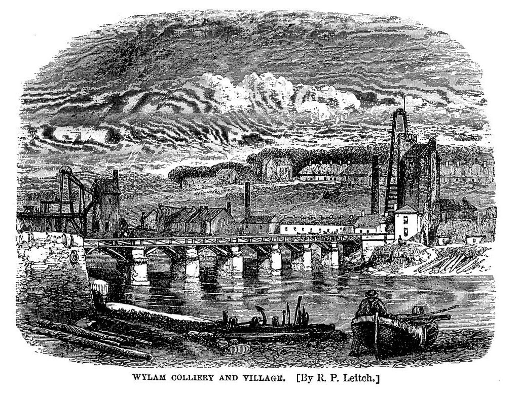
The illustration above of Wylam Bridge by R P Leitch was made for the 3rd edition of Samuel Smiles’ book, The Life of George Stephenson, published in 1868. It shows an industrial village with a coal mine and iron works along the northern riverbank and few buildings higher up in the village, including the colliery school built in 1854. Between the colliery pumping engine and the blast furnace stand the buildings of Wylam Mill, with another tall chimney.
Smiles described the village at he saw it.
“The colliery village of Wylam is situated on the north bank of the Tyne, about eight miles west of Newcastle. The Newcastle and Carlisle Railway runs along the opposite bank; and the traveller by that line sees the usual signs of a colliery in the unsightly pumping-engines surrounded by heaps of ashes, coal-dust, and slag, while a neighbouring iron-furnace in full blast throws out dense smoke and loud jets of steam by day and lurid flames at night. These works form the nucleus of the village, which is almost entirely occupied by coal-miners and iron-furnace-men. The place is remarkable for its large population, but not for its cleanness or neatness as a village; the houses, as in most colliery villages, being the property of the owners or lessees, who employ them in temporarily accommodating the work-people, against whose earnings there is a weekly set-off for house and coals.”
“There is nothing to interest one in the village itself.”
An article in The Newcastle Courant of 17 January 1874 entitled 'Our Colliery Villages' still described the village as “... the very worst colliery village that we have yet beheld …'
The late 18th century had been a period of prosperity for Wylam – the colliery was thriving and an iron works, a lead-shot manufactory and a brewery were all established in the village. In the mid 1750s, Blackett, the colliery owner had had the Wylam Waggonway constructed to transport coal from the Haugh Pit to Lemington, originally using horse-drawn wagons, but in the early 1800s using some of the earliest steam locomotives including Puffing Billy and Wylam Dilly.
Benjamin Thompson established the Wylam Iron Works in 1835; one of its blast furnaces can be seen on the right, close to the location in Falcon Terrace where the school was built in 1909-10 (now the library and railway museum). Few remains of this industry can still be found, although many of the garden walls in Wylam’s Main Road are built of slag.
In 1825, he became a director of the Newcastle and Carlisle Railway and surveyed the route for the line, supervising the later stages of its construction between 1833 and 1835. At the iron works, locomotives were built for several years and in 1836 he was responsible for the erection of Wylam Bridge to link the village (and his works) to the new railway. It was originally a combined road and railway bridge with a timber deck supported on stone piers. It was funded by public subscription and tolls. This replaced a small ferry boat and earlier, often hazardous ford.
In 1864 the iron works closed. Four years later the colliery was closed, Haugh Pit below the river flooded for the last time. The brewery ceased to operate sometime in the 1870s. In 1876 Wylam Mill was modernised and converted into a steam mill. In 1931, most of its buildings including its chimney were destroyed by fire although the former Mill Stables is now the new Co-op store.
In 1876 the Scotswood, Newburn and Wylam Railway was completed with its arch-rib designed bridge at Hagg Bank, too late for much of Wylam’s industry. The track of this railway, serving a new station at North Wylam, was built along much of the course of the old waggonway.
The timber decking of Wylam Bridge was replaced with steel in 1897 when the bridge was no longer in use by rail traffic. It was again replaced in 1946. In 1960 the bridge still had an old tollhouse at the south end where the station car park entrance is today, although the company had erected a new one at the north end in 1899. The house sports a Puffing Billy weather vane on its dormer window.
Pedestrians were charged one penny to cross but an agreement between the landowner and the bridge company allowed free passage to some of the well-off residents. Opposition to the tolls led eventually to its acquisition by Northumberland County Council and it was freed from toll in 1936.
In 1942 strengthening and widening was carried out by the Ministry Of Transport so that it could be used by tanks. Flood damage and erosion forced replacement of two piers in the 1950s and the bridge was widened in 1959 to 24 feet, including a 6 foot wide path. A weight restriction of 9 tons was imposed in 1960, later raised to 10 tons. Following concerns over the safety of the railings following impact by cars, the bridge was closed for several weeks in 2007 for safety improvements.
The decline of industry in the 19th century led to a substantial change in the character of the village. By the 20th century Wylam was almost entirely a residential settlement, its transport well served by two railway stations.
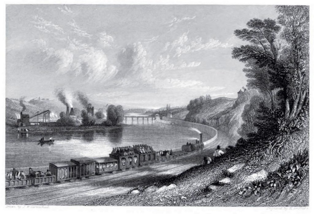
The length of river bank east of Hagg Bank is known as Wylam Scars and it was here that work on the Newcastle-Carlisle railway began in 1831. The scene was delightfully illustrated by J.W. Carmichael in one of his famous views of this railway. This was the first cross-country line to be built and the first section, between Blaydon and Hexham, opened on March 9th 1835.
Wylam Globe Supplement to Issue 41 (June 1988)
| wylamglobe41supplement.pdf |
 RSS Feed
