Heddon-on-the-Wall Local History Society
  • Home
  • Calendar
  • Introduction
  • Where are we?
  • History Map
  • Timeline
    • Prehistoric
    • AD43 to 1599
    • 1600 to 1799
    • 1800 to 1899
    • 1900 to 1999
    • 2000 to 2099
  • Heddon's History
    • Prehistory
    • Hadrian's Wall >
      • Vallum excavation (1893)
      • Hadrian's Wall excavation 1926
      • Wall ditch, Bays Leap (1958)
      • Hadrian’s Wall: Archaeological research by English Heritage 1976-2000
      • Throckley & Heddon entanglements
      • WallWatch
      • English Heritage (2020)
      • Wardell-Armstrong Archaeolgy Reports
      • Historic England Archives
    • Six townships >
      • 1 Heddon township >
        • Heddon in the Middle Ages
        • Common Land
        • Middle Marches
        • Tithe Award
        • St Andrew's Church >
          • Stained Glass Windows
          • Churchyard
          • Monuments of church & churchyard (1991)
          • Monuments Page 2
          • Vicars of Heddon
        • Village property
        • Heddon Hall >
          • Sale of Heddon Hall 2012
        • Heddon Banks Farm
        • Frenchman's Row
        • Methodist Church >
          • Heddon Methodist Church Centenary 1877-1977
        • Men's Institute
        • Women's Institute
        • Welfare Field
        • Knott Memorial Hall
        • Memorial Park
        • Schools
        • River Tyne
        • Coal Mining
        • Quarrying
        • Water Supplies
        • Transport
        • Waggonway & Railway
        • Occupations from 1800
        • Miscellaneous
      • 2 West Heddon township
      • 3 East Heddon township
      • 4 Houghton & Close House township >
        • Close House
      • 5 Eachwick township
      • 6 Whitchester township
    • Rudchester
  • People
    • Sir James Knott
    • Cadwallader J. Bates
    • Richard Burdon
    • Hugh Sinclair (Tim) Swann
    • George Clark
  • Old Photos
    • Postcards
    • Old photos 1
    • Old photos 2
    • Old photos 3
    • Old photos 4
    • Old photos 5
    • Old photos 6
    • Old Photos 7
  • Old News
    • Community News
    • Letter from the Emigrant Clergy of Frenchman's Row (1802)
    • Alleged Brutal Murder at Heddon-on-the-Wall (1876)
    • Sad boat accident at Ryton (1877)
    • Coronation tree (1902)
    • 65 Years on a Ferry Boat (1929)
    • Come claim your kiss at Heddon (1953)
    • The Swan (1972)
    • Heddon WI (1987)
    • Church House (1966)
    • Happy return (1993)
    • Hexham Courant (1997)
    • Butterfly Garden (1999)
    • Foot & Mouth (2001)
    • Remembrance Day (1996)
    • Remembrance Day (2016)
    • RAF at Ouston (2007)
    • Close House Golf Course (2009)
    • Heddon pupils celebrate British heritage (2011)
    • Roman Wall Forge (2011)
    • Diamond Jubilee (2012)
    • Auction of Bronze Statue, Close House (2012)
    • Heddon WI (2012)
    • Puffing Billy Festival (2013)
    • Heddon Village Show (2014)
    • View of the North (2014)
    • The Wall at Heddon (2014)
    • Heddon Village Show (2015)
    • War veterans singing send-off (September 2015)
    • Anglo-Saxon history (2014)
    • Heddon WI at 100 (2017)
    • Hadrian's Wall discovery (2019)
    • Tulip Mews (2020)
    • Mike Furlonger
    • Hadrian's Wall 1900 Festival
  • Memories
    • Olive White
    • Betty Cockburn
    • Betty Cockburn - miscellaneous information
    • Isabel Snowdon
    • William & Winnie Watson
    • Edith Ward
    • Mark Parker
    • Jack Lawson
    • Winnie Spoor
    • P Reay
    • Mr and Mrs Hall
    • Peter Chapman
    • Elizabeth Elenora Eames
    • Harry Murray
  • Other documents
    • Mackenzie (1825)
    • Bates (1886) >
      • Early & Roman
      • Townships
      • Heddon Church
      • Heddon & Houghton
      • Whitchester
      • Eachwick
      • West & East Heddon
      • Records
      • Addenda
      • Appendix A
    • History, Topography & Directory of Northumberland (Bulmer's) - 1886
    • History of Northumberland (1930)
    • Collingwood Bruce (1853)
    • Whellan (1855)
    • Post Office Directory (1879)
    • Prominent people in Heddon
    • Place names
    • Ad Murum
    • Archived documents
    • Thomas Bewick's History of British Birds (1826)
    • Census data 1801-1991
    • Historical Records 1888-1890
    • Knott Sale of Village Property (1924)
    • Extracts from Parish Council Records
    • Local colliery records
    • Blackburn (1938)
    • Clark (c.1963)
    • History of Church (1968)
    • Boundary Commission Report 1984
    • Village Atlas 2022
  • Walks
    • Walks 2
  • Blog
  • Contact us
  • Links
  • What's new
  • Site search
  • Past & Present
  • Photo of the Month
  • Place Name Studies
    • Meas & Meres
    • OS Name Books: Elsdon
    • OS Name Books: Allendale
    • OS Name Books: Cheviot Hills

The Black Dyke

26/3/2014

1 Comment

 
Picture
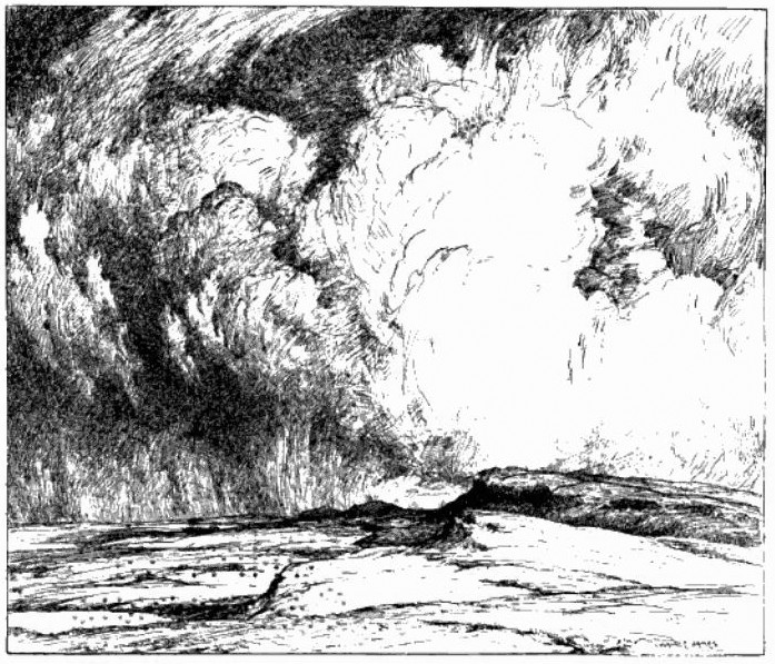
Sewingshields Crag from the West. From a pen and ink drawing by Hon. W J James in Spain (1822)
I have just had the honour to help with a field archaeology survey of land north of Hadrian's Wall at Sewingshields over four days in March. I was employed as a volunteer with the Tynedale Archaeology Group.  During our recording of several stack stands (used to store winter fodder), old field boundaries and occasional settlements, I became acquainted with the Black Dyke, a long linear earthwork that tracks some distance through Northumberland, something I had only before seen on maps.
There is another, better known long earthwork, the Devil's Causeway, which can also be traced through the county. This, however, is actually a Roman road. It branches off Dere Street (the modern A68) where it crosses the Military Road at Port Gate, north of Corbridge, and runs in long straight lines north to the mouth of the River Tweed at Berwick.
The Black Dyke is one of the mysteries of Northumberland. It is a linear earthwork consisting of an embankment with a ditch on its west side, both of variable size, and completely untraceable in some areas. A definitive description was presented to the Society of Antiquaries of Newcastle-upon-Tyne by George R B Spain in November 1921, and published in their journal, Archaeologia Aeliana, Ser.3, Vol.19, p.121-168 (1922).
Picture
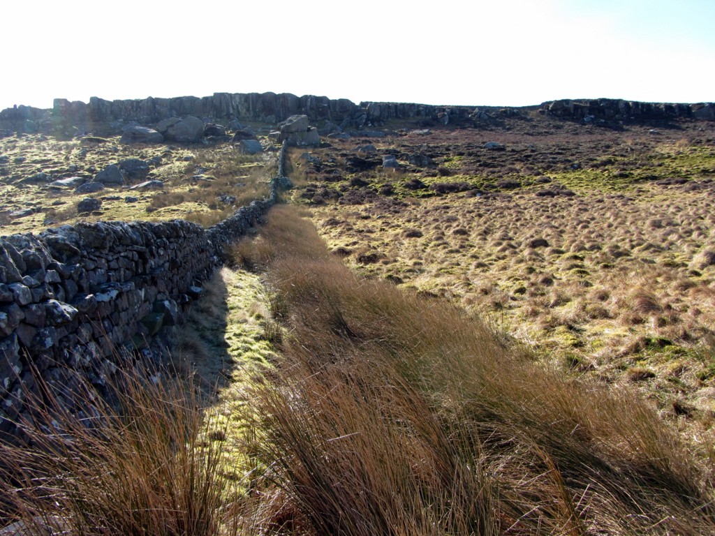
The Black Dyke followed by modern boundary wall. View south to Queen's Crags. Photo A Curtis (2014).

Read More
1 Comment

Newcastle Swing Bridge

20/3/2014

0 Comments

 
Picture
Neptune and Swing Bridge, Newcastle. Photo A Curtis (2014).
Newcastle's Swing Bridge, thought to have been the fourth bridge that crossed the River Tyne at low level on the site, was designed by Lord Armstrong and the Tyne Improvement Commission. It was built at Armstrong's Elswick works between 1868-76 at a cost of £222,000. At the time of its opening it was the largest such bridge in the world. It was a necessary development to allow for upriver navigation by sea-going vessels but required the removal of the current nine-arched stone bridge built in 1781.

The bridge mechanism is still driven by the original Armstrong hydraulic engines, although the steam pumps were replaced by small electric pumps in 1959. The pumps force water into the chambers of hydraulic accumulators, sunk down into the bed of the river. When the motors cut out, 60-ton weights above the chambers force water out under pressure which run the machinery to turn the bridge. The bridge now opens only very rarely and is controlled from the cupola above the superstructure.
Picture
Tyne Improvement Commission coat of arms, Swing Bridge Newcastle abutment. Photo A Curtis (2013).

Read More
0 Comments

Improving the Tyne

11/3/2014

0 Comments

 
Picture
Window above doorway to Tyne Improvement Commission's Bewick House, Newcastle. Photo A Curtis (2014).
Bewick House in Bewick Street, Newcastle, close to Central Station, was built to provide offices for the Tyne Improvement Commission. It clearly was of no interest to have a location nearer to the river which probably reflects the more commercial interests of the Commission and the more general move of the city to the north in the mid C19th.

In 1854, the commissioners started a programme of development and improvement of the river that continued well into the C20th and laid the foundations for what was to become the modern-day Port of Tyne. Within 70 years, the River Tyne was deepened from 1.83 metres to 9.14 metres and over 150 million tonnes dredged from it. The North and South Piers at the river's entrance were built, together with the Northumberland, Tyne and Albert Edward Docks, and the staithes at Whitehill Point and Dunston. The results of these developments could be seen in 23 million tonnes of cargoe being handled by the Port by 1910.

On 31st July 1968 the Tyne Improvement Commission was dissolved and replaced with the Port of Tyne Authority, constituted on 28th June, and one of the UK’s largest trust ports.

The newspaper article from 1897, transcribed below, describes 'above bridge developments' of the 'great improvement scheme'.

Read More
0 Comments

    RSS Feed

    Author

    Andy Curtis

    Archives

    February 2023
    November 2022
    September 2022
    August 2022
    June 2022
    May 2022
    January 2022
    December 2021
    November 2021
    September 2021
    August 2021
    June 2021
    May 2021
    October 2020
    June 2020
    May 2020
    March 2020
    November 2019
    August 2019
    July 2019
    March 2019
    January 2019
    November 2018
    October 2018
    August 2018
    July 2018
    June 2018
    April 2018
    March 2018
    January 2018
    October 2017
    September 2017
    July 2017
    June 2017
    May 2017
    April 2017
    March 2017
    February 2017
    January 2017
    December 2016
    November 2016
    September 2016
    August 2016
    July 2016
    June 2016
    May 2016
    April 2016
    February 2016
    January 2016
    December 2015
    October 2015
    September 2015
    August 2015
    July 2015
    June 2015
    May 2015
    April 2015
    March 2015
    February 2015
    January 2015
    December 2014
    November 2014
    September 2014
    August 2014
    July 2014
    June 2014
    May 2014
    April 2014
    March 2014
    February 2014
    January 2014
    December 2013
    October 2013
    September 2013
    August 2013
    July 2013
    June 2013
    May 2013
    April 2013
    March 2013
    February 2013
    January 2013
    December 2012
    November 2012
    October 2012
    September 2012
    August 2012
    July 2012
    June 2012
    May 2012
    April 2012
    March 2012
    December 2011
    November 2011
    October 2011
    September 2011
    August 2011
    June 2011
    May 2011
    April 2011
    March 2011
    February 2011


    Categories

    All
    Agricultural Engineering
    Archaeology
    Barrow
    Bays Leap
    Beamish Museum
    Beer
    Beer-mat
    Bewcastle
    Books
    Border Line
    Brewery
    Brown
    Cabinetmaker
    Charlton
    Cheviots
    Churches
    Civil War
    Clennell Street
    Close House
    Coal Mining
    Cullercoats
    Cumbria
    Eachwick
    Earl Grey
    Elswick
    Family History
    Fishing
    Fishwives
    Folkestone Warren
    Forth Banks
    Furniture
    Gardens
    General
    George Clark
    Gibson
    Goods Station
    Hadrian's Wall
    Harbours
    Heddon
    Heddon Hall
    Hexham
    Hidden Chains
    Houghton
    Howick Hall
    Hunting
    Iron Sign
    Isaac Jackson
    John Grundy
    John Smith
    Knott
    Landslide
    Lead Works
    Lemington
    Lindisfarne
    Maritime
    Meetings
    Military Road
    Mill
    Monument
    Newburn
    Newcastle
    Newcastle Assizes
    News
    North Lodge
    North Shields
    Northumberland
    Northumberland Records Office
    Old Middleton
    Oral History
    Ouseburn
    Outings
    Photography
    Place Names
    Place-names
    Ponteland
    Ports
    Prehistory
    Pubs
    Quarries
    Railways
    Redesdale
    River Tyne
    Rock Art
    Roman
    Sadler
    Sanderson
    Schools
    Seaton Delaval
    Ships
    Shot Tower
    Slave Trade
    Songs/Poems
    Spearman
    Stagecoach
    Stained Glass
    St. Andrews
    Stephenson
    Swann
    Tea Robbery
    Throckley
    Town Farm
    Transportation
    Trinity House
    Victorian Panorama
    Walbottle
    Walk
    Water Supply
    William Brown
    Williamson
    Woodhorn
    Ww1
    Ww2
    Wylam
    Yetholm

Powered by Create your own unique website with customizable templates.