
The Heddon history time-line is based on work by Pat Farnaby for his previous village web site.
Neolithic (4,000 to 2,500 BC)
Three blades/flakes and one graver (engraving tool) from Heddon Law (Mesolithic). Link
Three Neolithic polished stone axes were found together by a Mrs S Munroe just below the surface while digging in the back garden of a house in Antonine Walk, Heddon-on-the-Wall in March 1963. Subsequent excavation recovered a further axe plus a possible rough-out and axe fragments, all apparently of the same light green igneous rock as the first three axes. Link
Two standing stones, the tops of them barely visible, used to stand in the field north of the Newburn and Wylam Railway, near Stannerford (Close House). They are mentioned ('Standande-Stan') in a boundary dispute of 1290 between Richard Turpin of Houghton and the Prior of Tynemouth. These stones have long been removed. Link
Bronze age (2,500 to 800 BC)
Cup and ring marked stones – no such stones have been officially recorded from Heddon but there is one carved boulder (although not in its original site) very close to the parish, just over the border at Throckley Bank Top Link and others just south of the Tyne in Ryton. Link Link Link Link
A water-worn, possibly cup-marked cobble was found by the bed of the River Tyne just south of Close House by A Curtis in 2008.
Bronze age round cairn on Heddon Law. Link
Possible Bronze Age cairn on Turpin's Law, although reused for Roman burials (excavated in 1771 and 1795). Link
Bronze socketed and looped axe found while cutting a section across the Vallum near Great Hill in 1893. Link
Bronze Age palstave (early bronze axe) and bronze crucible found on an island in the Tyne, exposed at low tide, near Cathouse Plantation south of Heddon-on-the-Wall. Link
Iron Age (800 BC to 43 AD)
A defended settlement of Iron Age date is sited on gently sloping ground just west of Houghton. The oval enclosure is over 100m wide. The ditch has become filled-in along most of its length, but can still be seen on the northern side. The remains of a stone and earth rampart can also be seen. Link
A defended settlement of Iron Age date is sited on gently sloping ground just west of Houghton. The oval enclosure is over 100m wide. The ditch has become filled-in along most of its length, but can still be seen on the northern side. The remains of a stone and earth rampart can also be seen. Link
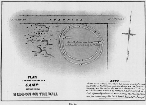
Plan of camp at Houghton. History of Northumberland Vol. 13 (1930)
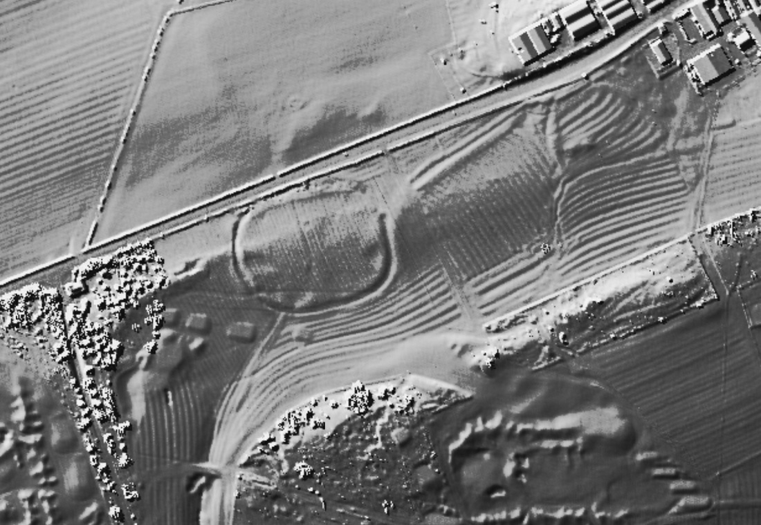
LIDAR image from 1m DSM data copyright Environment Agency.
Traces of hut circles were reportedly seen on Heddon Common and on the Resting Hill by CJ Bates in 1880. Link
Heddon Common is now largely covered by disused quarries and part of the area, centred NZ 134 667, is now developed as a housing estate. If this report is true, this would indicate that the village was inhabited during this period. Link
Resting Hill is a field name shown on a 1780 plan on the steeply sloping hillside just south of Station Road below the village (NZ 137 665).
However, investigation of aerial photographs of Heddon Common taken in the 1930s before development, revealed two circular banked enclosures, 8 metres (NZ 1284 6680) and 5 metres (NZ 1286 6680) in diameter. These were interpreted as being likely post-medieval stack stands used for the storage of winter fodder. Link
A log-boat was discovered on the south side of the River Tyne, north-east of Clara Vale, after flooding in 1926: it was suggested to be Iron Age. Link
After the Tyne had been in flood and scoured the south bank near Ryton and Clara Vale in October 1926 a log-boat was found on a gravel layer beneath 16 feet of alluvial clay. It was flat-bottomed, had a bluntly pointed bow and a squared stern, and had been cut out of a single oak log. Its length was recorded as 9 feet 2in (2.75 m), its width 1 feet 10 in (63 cm), and draught originally 1 feet 6 in (46 cm) with 1 in (2.5 cm) thick sides. It was thought to be of Iron Age origin.
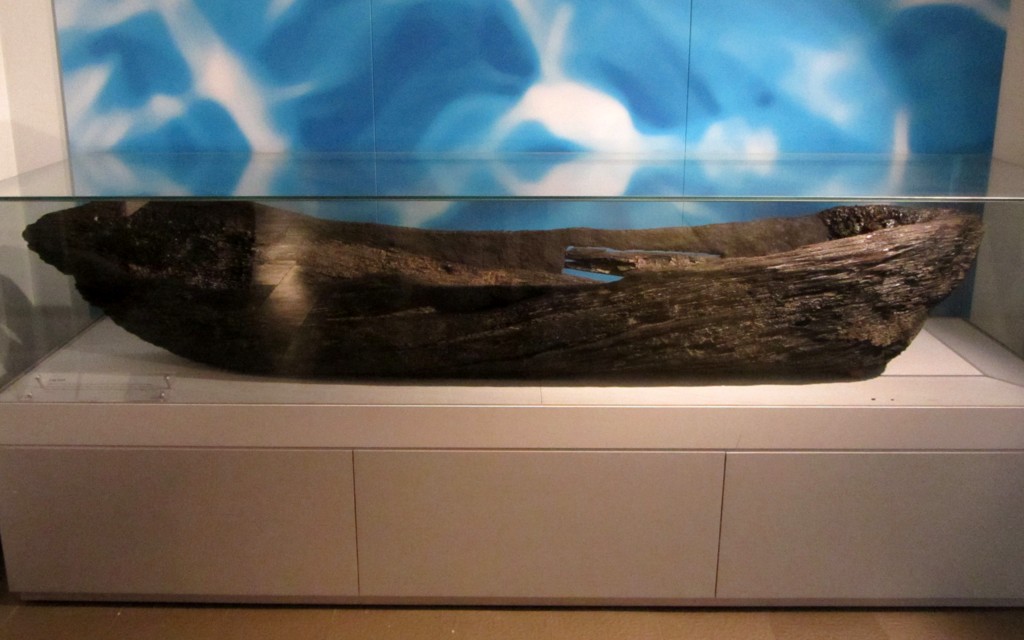
Log boat found at Ryton. Newcastle Discovery Museum. Photo by A Curtis (2014).
A wooden wheel, said to be of Iron Age type, was found in the same area in 1927. Link
In 1926-27 flooding of the Tyne scoured the south bank near Ryton, close to Clara Vale, revealing a wooden wheel some 150 yards west of the log-boat found in 1926. It lay on gravel, under 16 feet of alluvial sand and clay. The wheel had a hub 15.5 in long, with an external diameter of 5.75 in, swelling to 8.5 in at the centre where the 9 spokes were inserted. The spokes were 12.5 in long, and the diameter of the whole wheel was 38.75 in. The remains of an iron tyre were visible. The wheel, which could not be preserved intact, was suggested by Piggott as Roman or earlier in date, a product of the Pre-Roman Iron Age tradition.
In 1926-27 flooding of the Tyne scoured the south bank near Ryton, close to Clara Vale, revealing a wooden wheel some 150 yards west of the log-boat found in 1926. It lay on gravel, under 16 feet of alluvial sand and clay. The wheel had a hub 15.5 in long, with an external diameter of 5.75 in, swelling to 8.5 in at the centre where the 9 spokes were inserted. The spokes were 12.5 in long, and the diameter of the whole wheel was 38.75 in. The remains of an iron tyre were visible. The wheel, which could not be preserved intact, was suggested by Piggott as Roman or earlier in date, a product of the Pre-Roman Iron Age tradition.
Dodds, W. (1964). The Ryton dug-out canoe. Archaeologia Aeliana Series 4. Vol 42, pp. 285-288.
https://doi.org/10.5284/1060426
https://doi.org/10.5284/1060426
