
I was privileged to be invited to see these two massive old maps last week. Based on sections of large scale Ordnance Survey maps, they have routes of Newcastle's buses, trams, trolley-buses and train routes painted on by hand. They had been designed to be hung up on a large wall somewhere and had been stored in a long and heavy wooden box. They had been rescued from disposal by David Vardy and brought to my attention by both Bill and Lil of Heddon who use a local Facebook page.
See below for more details and some recent research.
See below for more details and some recent research.
The origin of the box with its two maps was from a demolished property somewhere along the River Tyne, perhaps a storage warehouse of the town council.
An auction label on the wooden box showed that the maps had been in an auction by ADG Auctions of Blyth on 10th July 2021 as lot 736.
The lot was described only as 2 x 1920 local maps huge size approx. 18ft x 10ft, reused in war period 1944. Contained in large oak container.
There was no reserve price and the lot appeared to remain unsold and probably disposed of due to its condition.
The background maps can be identified as below:
- Smaller scale: Ordnance Survey 1921 1:10,560 (6" to 1 mile) .
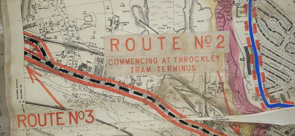
- Larger scale: Ordnance Survey 1919 1:2,500 (25" to 1 mile)
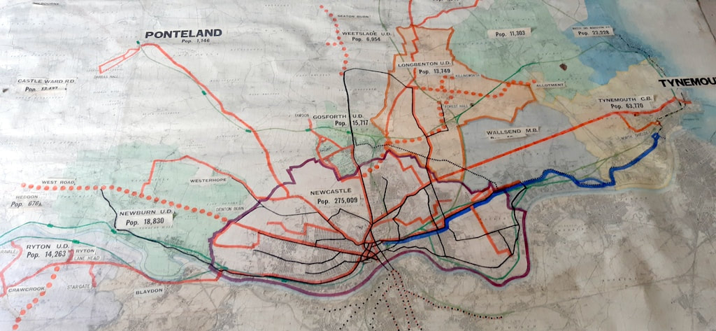
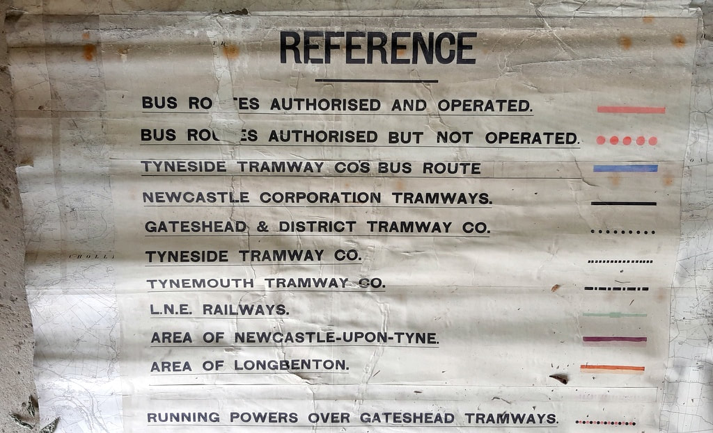
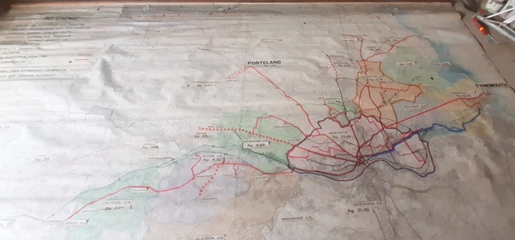
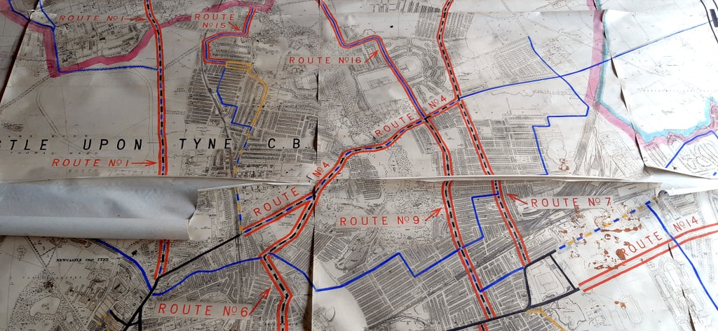
The plan based on the 6" OS Map shows the existing tram line on the Scotswood Road though Lemington and Newburn terminating at the cross roads in Throckley. The population of Newburn Urban District is given as 18,830. An existing bus route along the West Road terminates at Denton Burn but is marked as authorised but not operated further west as far as Heddon on the Wall. The population of Heddon is recorded on the plan as 676.
To the north, a bus route serves Ponteland and Darras Hall (population 1,146). The train line to Ponteland Station via Gosforth is also shown on the plan but had been closed to passenger traffic on 17 June 1929 due to competition with the buses. Ponteland remained open for goods traffic until 14 August 1967.
To the north, a bus route serves Ponteland and Darras Hall (population 1,146). The train line to Ponteland Station via Gosforth is also shown on the plan but had been closed to passenger traffic on 17 June 1929 due to competition with the buses. Ponteland remained open for goods traffic until 14 August 1967.
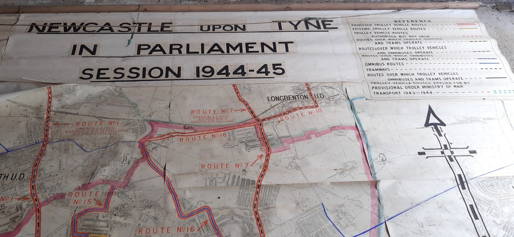
The larger scale map is titled:
Newcastle upon Tyne in Parliament Session 1944-45.
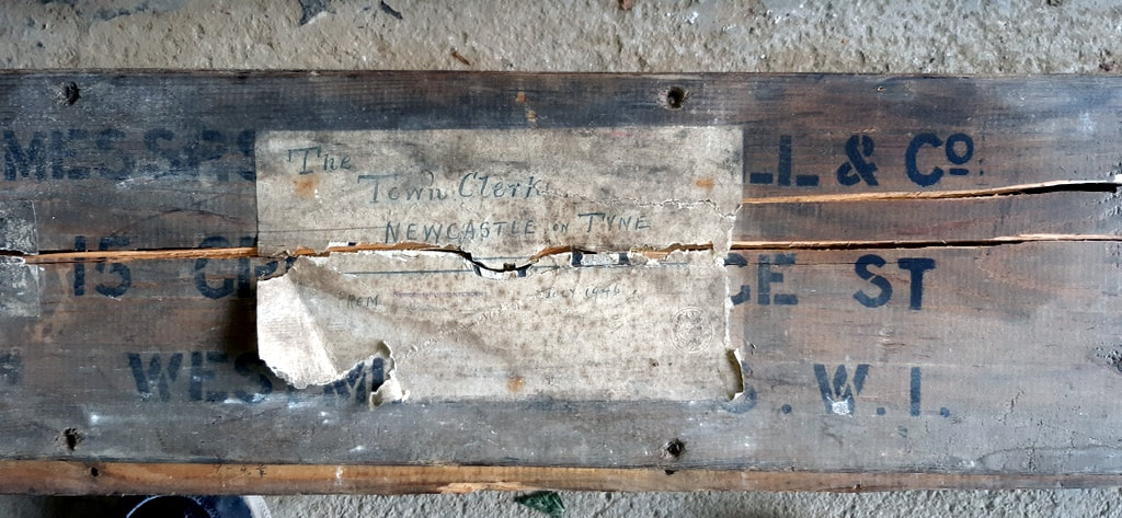
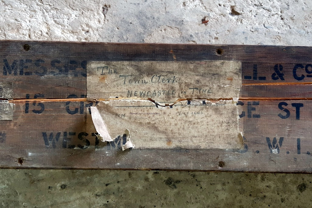
Both plans are stored in a long wooden box which appears to have come from Westminster (probably made by a company at 15 Great George Street in W1 although that is only a guess from the incompletely read labels), and addressed to The Town Clerk of Newcastle upon Tyne. It had been sent by Resident Superintendent, House of Lords in July 1946.
Both maps are massive and would require conservation if anyone wants them, as the paper maps are peeling off their backing.
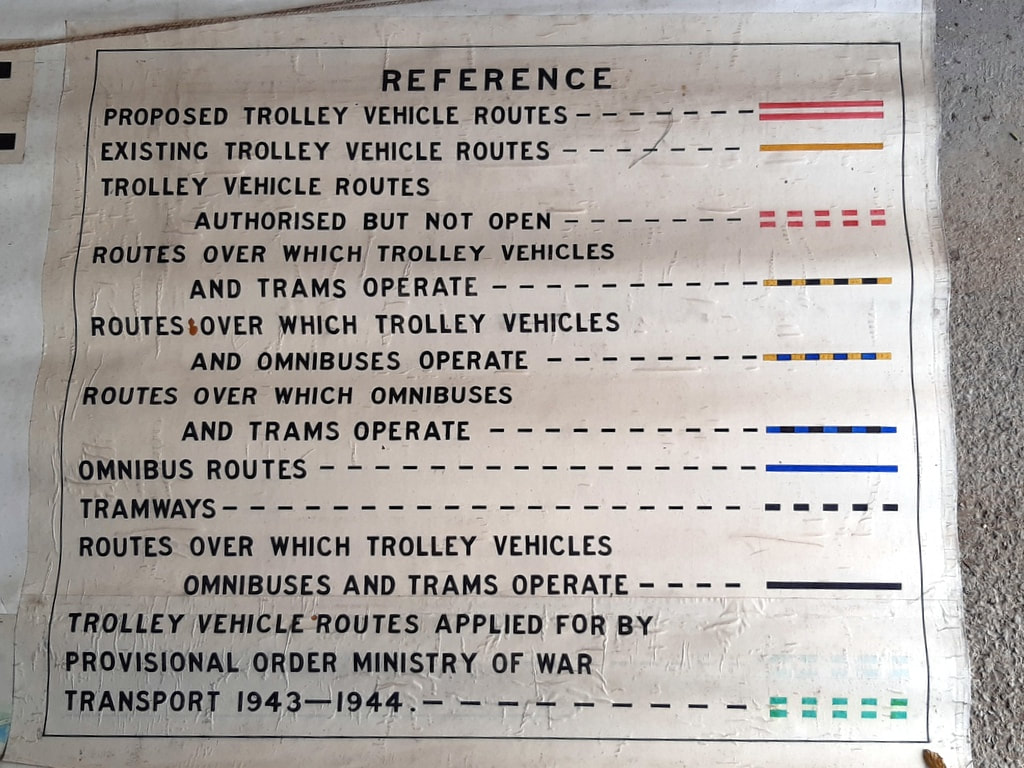
A quick check of parliamentary records suggests they could have been something to do with proposed Newcastle trolley-bus routes.
Newcastle upon Tyne in Parliament Session 1944-45.
Both plans are stored in a long wooden box which appears to have come from Westminster (probably made by a company at 15 Great George Street in W1 although that is only a guess from the incompletely read labels), and addressed to The Town Clerk of Newcastle upon Tyne. It had been sent by Resident Superintendent, House of Lords in July 1946.
Both maps are massive and would require conservation if anyone wants them, as the paper maps are peeling off their backing.
A quick check of parliamentary records suggests they could have been something to do with proposed Newcastle trolley-bus routes.
Entry in Journal [15th May, 1945] read: —Bill "to confirm, a Provisional Order made by the Minister of War Transport under the Newcastle-upon-Tyne (General Powers) Act, 1935, relating to Newcastle-upon-Tyne Trolley Vehicles," read the First and Second time, and (the Bill having been reported and considered in the last Parliament) ordered to be read the Third time To-morrow.
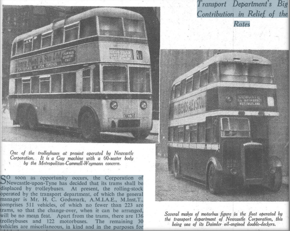
So soon as opportunity occurs, the Corporation of Newcastle-upon-Tyne has decided that its trams shall be displaced by trolleybuses. At present, the rolling-stock operated by the transport department, of which the general manager is Mr. H. C. Godsmark, A.M.I.A.E., M.Inst.T., comprises 511 vehicles, of which no fewer than 223 are trams, so that the change-over, when it can be arranged, will be no mean feat. Apart from the trams, there are 136 trolleybuses and 122 motorbuses. The remaining 30 vehicles are miscellaneous, in kind and in the purposes for which they are used.
The combined services, as they exist at present, are excellent, considering the conditions brought about by the war. Mr. Godsmark, like everyone else in a similar position, suffers from a shortage of labour and materials and is anxious to give improved travel facilities to the people of Newcastle notwithstanding these difficulties which affect, alike, the trams, trolleybuses and motorbuses.
The corporation services spread fanwise from the north bank of the River Tyne, with the bridge over the river as a focal point. They reach Throckley, six miles to the west; Tynemouth, eight miles to the east; Gosforth Park and Ponteland, five and nine miles respectively to the north.
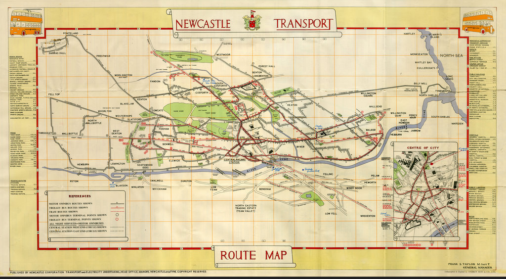
Beamish Transport Online have a nice Newcastle Corporation Transport map (trolley-buses, trams and buses) from 1949 (published for use by public) although with no background OS. It is nice to imagine that the 1944-45 maps shown here were a forerunner for this later public service map.
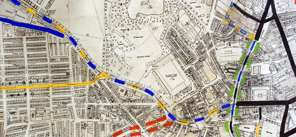
Some of the tram routes on the 1944-45 maps (Throckley/Lemington) have been replaced by buses. However, trams still cross the Tyne & High Level Bridges on their way from Newcastle town centre to Gateshead.
Some of the tram routes on the 1944-45 maps (Throckley/Lemington) have been replaced by buses. However, trams still cross the Tyne & High Level Bridges on their way from Newcastle town centre to Gateshead.
A comment on this map on the website Transit Maps points out:
Interestingly, the main map seems to be presented at a slightly oblique angle almost as if the view was from an aeroplane high above the city. Distances along the north-south axis are somewhat compressed, and everything leans to the left a little. The bridges over the River Tyne are drawn in a way that reinforces this perspective, so the effect is quite convincing.
Interestingly, the main map seems to be presented at a slightly oblique angle almost as if the view was from an aeroplane high above the city. Distances along the north-south axis are somewhat compressed, and everything leans to the left a little. The bridges over the River Tyne are drawn in a way that reinforces this perspective, so the effect is quite convincing.
Perhaps someone had based it on the perspective of one of the massive maps laid out on the floor and observed from the bottom.
Co-Curate provides the following potted history of Newcastle's Trolleybus network.
October 2, 1935
Newcastle Trolleybus System opens
The Newcastle upon Tyne trolleybus system opened on the 2nd of October 1935. These were electric buses, drawing power from overhead cables through spring-loaded trolley poles. Unlike the trams they replaced, trolleybuses didn't require tracks. The trolleybus system gradually replaced the Newcastle tramway network, eventually growing to a fleet of 204 trolleybuses covering 28 routes..
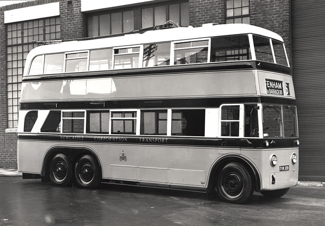
An undated view of a Newcastle Corporation Transport trolleybus parked outside the depot Newcastle upon Tyne. The trolleybus is used on the no.?6 route to Fenham via Barrack Road.
Newcastle Libraries Collection Accession Number: 054254.
1946
Newcastle Trolleybus Network - Expansion
Newcastle Corporation ran a programme of modernisation and expansion of it's trolleybus network between 1946 and 1949. During that period 186 new trolleybuses were ordered, replacing the original fleet of around 100, and expanding the network to cover 37 route miles.
October 2, 1966
Newcastle Trolleybus System closes
The Newcastle Trolleybus System closed in October 1966, after 31 years of operation. The electric trolleybuses were replaced by petrol buses. Some of the trolleybuses were scrapped, others were redeployed to trolleybus networks in other parts of the country.
Newcastle Trolleybus System closes
The Newcastle Trolleybus System closed in October 1966, after 31 years of operation. The electric trolleybuses were replaced by petrol buses. Some of the trolleybuses were scrapped, others were redeployed to trolleybus networks in other parts of the country.
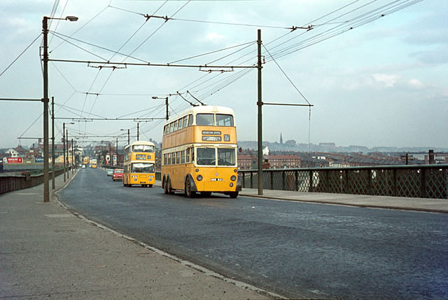
British Trolleybuses - Newcastle upon Tyne. Photo by Alan Murray-Rust (1966).
Photo from Geograph © Copyright Alan Murray-Rust (cc-by-sa/2.0) Link
Byker Bridge in 1966 looking east. The distinctive supports for the overhead wires have disappeared, and we seem to need crash barriers these days.
The trolleybus is no.621, one of the batch of BUT 9641T vehicles built in 1950 to the same design as the last trolleybuses built for London. By this stage only the main route 35 corridor was still operated by trolleybuses, the final closure coming the following year. .
David Vardy managed to find a new home for the maps - the museum of the Blyth Battery.
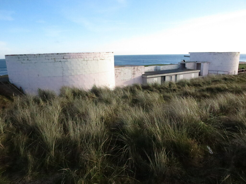
Gun Emplacements, Blyth Battery, South Beach, Blyth. Photo by Geoff Holland (2020)
Anthony Fox
30th September 2021
Hi Just noticed your item about the two Newcastle Corporation Transport maps.
In April 1931, the Corporation applied to the new Traffic Commissioners for Road Service Licences for the stage carriage services it wished to continue operating. This was a process gone through by all bus service operators as a result of The Road Traffic Act of 1930.
The 6" map matches exactly the bus routes that the Corporation listed in its application so can be dated as early 1931. In corroboration, the map shows the no. 12 Haymarket to Two Ball Lonnen route that started in July 1930, so the map must be later than that date, and the 11a Haymarket to North Shields via the New Coast Road, that no longer appeared in the December 1931 timetable, so the map must be earlier than that date.
The other map is much easier to date, not least because of the label! The proposed trolleybus routes in the Osborne Road/South Gosforth area are of note in that what actually happened was quite different.
Hope this is of interest.
Tony Fox, Market Drayton
 RSS Feed
