
The Ryal tunnel (1859) and Whittington tunnel (1905) were constructed to convey water from sources in the Hallington area, and further north-west, to the reservoirs at Whittle Dean. They were built to improve the supply of fresh water to the growing population and industrial use in Newcastle & Gateshead.
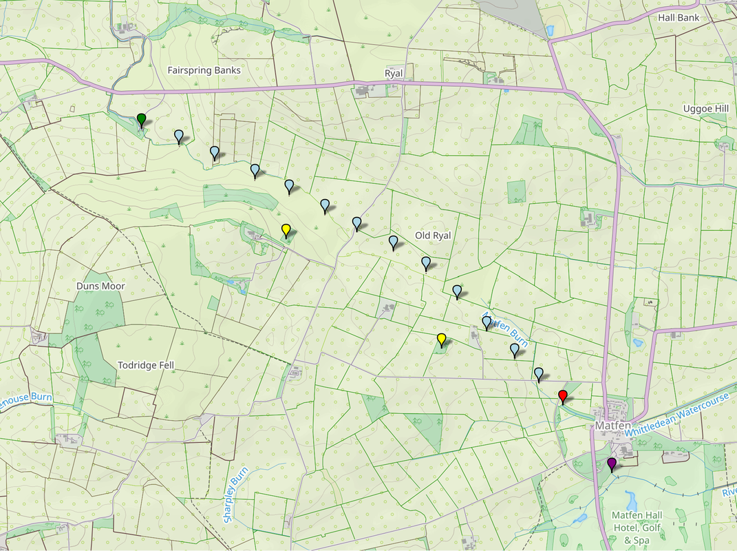
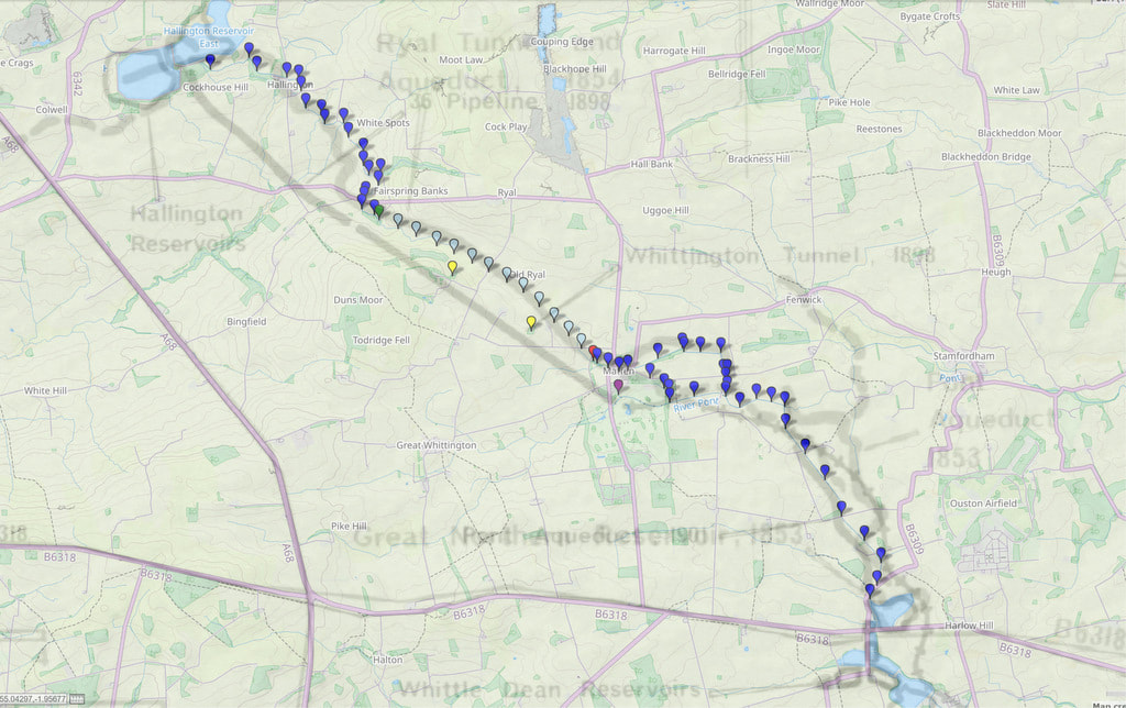
Map plotting the location of observable remains of the 12 shafts sunk in construction of the Ryal tunnel along with its entrance and outlet. Also shown are locations of the two shafts used to construct the later Whittington tunnel which is parallel and to the south of the first.
Around 1860, as part of creating the new 6" to 1 mile Ordnance Survey map for this area, the team whose job it was to collect the names to go on the new map recorded several instances of the name, Whittledean Water Course.
The OS Name Book for Stamforham p87 records:
"A work in the course of formation. When finished it will greatrly increase the comforts of the inhabitants of Newcastle as it will supply them with good water and plenty of it. The name only applies to the open water course & not to the tunnelled portion as that of course is not visible."
However the name, Whittledean Waterworks did get applied to part of the tunnelled section in the region of Cobs on the first edition 6" map (Northumberland Sheet LXXVIII Surveyed: 1859, Published: 1866), where the map shows part of the line of shafts, each in a small enclosure.
The Name Book description (St John Lee p17) states:
"It [water] is conveyed through an arch in this part of the parish it has a few shafts to facilitate communication
if repair be necessary, in the neighbourhood of Hallington it is an open water course having its sides faced with rubble
stone & is about 5 foot deep."
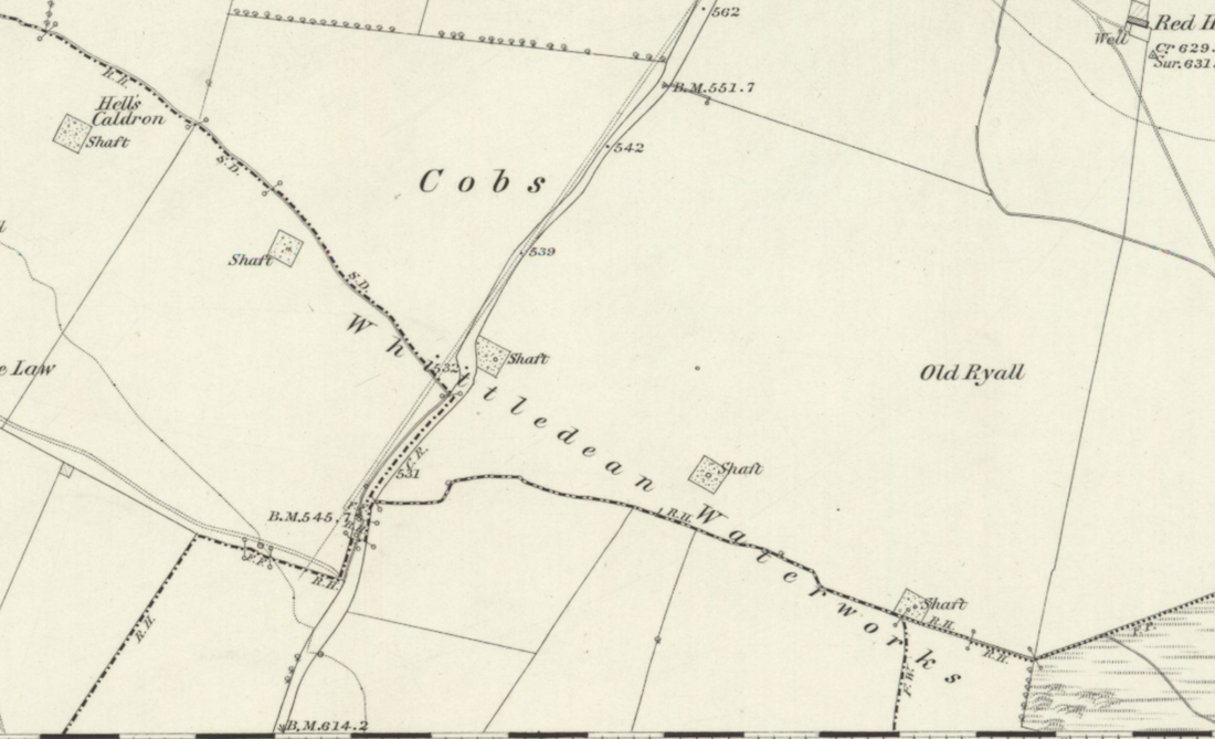
Northumberland Sheet LXXVIII Surveyed: 1859, Published: 1866.
Later OS maps do not show the name and although the locations of all 12 shafts are still quite visible today, and the eartrhworks themselves are shown on large scale maps, their purpose has been forgotten, and they are often interpreted as shafts for coal mining.
Perhaps this is not so surprising as 11 of the 12 shafts (and the two later ones used to construct the parallel Whittington tunnel) are shown as Mine Entries on the Coal Authority Interactive Map. The nearest true coal shafts, however, are to the south-east on Todridge Fell.
Perhaps this is not so surprising as 11 of the 12 shafts (and the two later ones used to construct the parallel Whittington tunnel) are shown as Mine Entries on the Coal Authority Interactive Map. The nearest true coal shafts, however, are to the south-east on Todridge Fell.
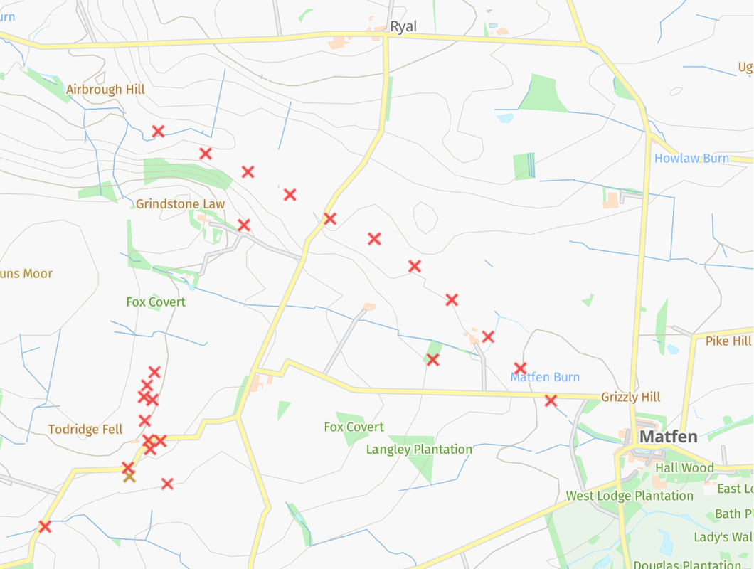
Excerpt from the Coal Authority Interactive Map showing shafts of Ryal & Whittington tunnels.
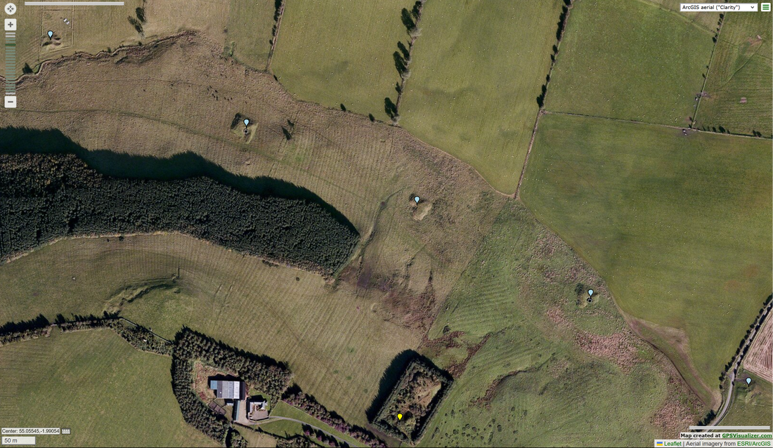
Remains of 5 shafts of the Ryal tunnel north of Grindstone Law (blue labels), and western shaft of the Whittington tunnel just east of the farm (yellow label).
The entrance to the Ryal tunnel is just west of Airbrough Hill, about 2km west of Ryal, where the open Whittledean Water Course from Hallington goes under the road close to the (now) aptly named, Waterworks Cottage. Water flows by gravity through the 2 mile long tunnel to emerge in a cutting near West Farm at Matfen. It is conveyed from there, mainly via open aqueduct, to the northern reservoir at Whittledean.
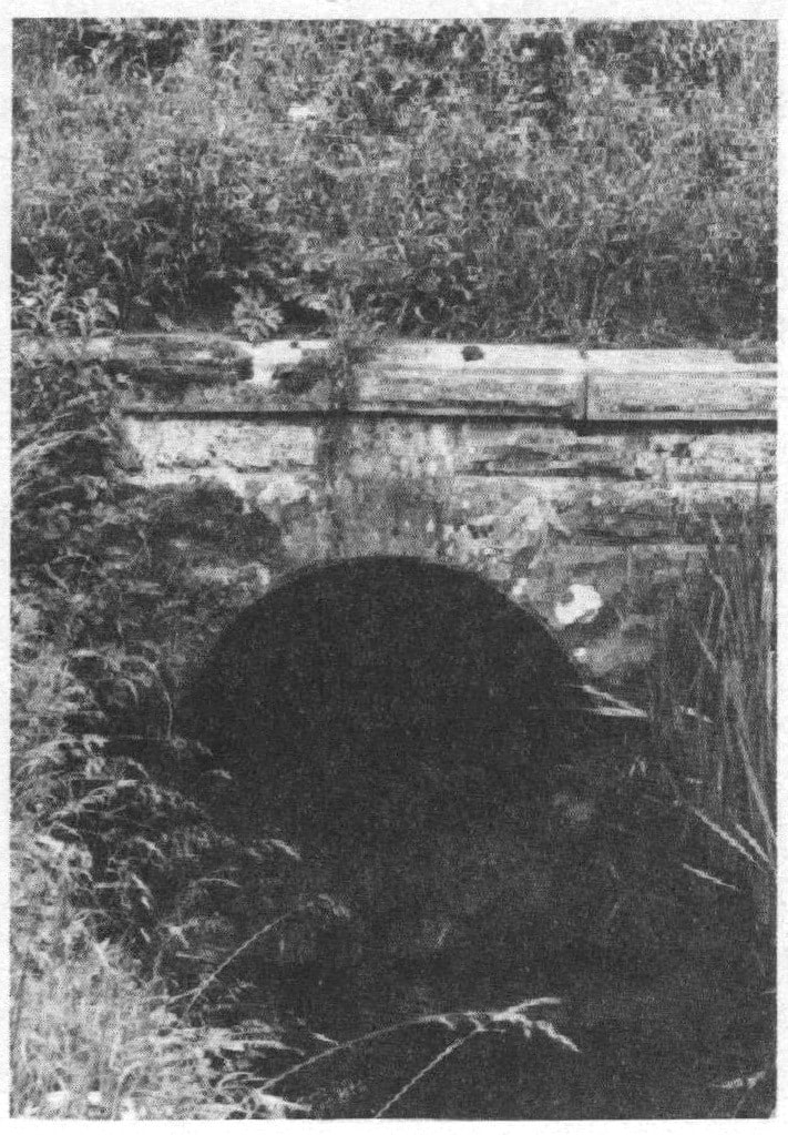
Outlet of Ryal Tunnel. Fig. 15 from Rennison (1979) p.69
If it is to be believed, the OS Name Books describe an impressive feature close to the works at the fourth shaft (from the tunnel's west end). Hell's Caldron (St John Lee p.17): "A slight indentation in the ground before
the formation of the water works (a few years ago)
it was a natural fountain the water boiling
to the height of about 4 feet a small indentation
in the grass is all that now remains of it".
One of the authorities for the name was one William Coulson who lived at Grindstone Law. A paper by him was presented to the Society of Antiquaries of Newcastle in 1860 and published in their journal (W Coulson, 1861. Denisesburn. Archaeologia Aeliana Series 2. Vol 5, pp. 103-108). In the paper he describes the Caldron and its legend: "Grass covers its site, and the tradition is sinking into forgetfulness, living still, however, in the memory of many. Some there are who have seen the Cothem in its pristine state, and remember the awe which the story imparted to a sight of it."
Rennison (1979) wrrote (p.229) that around 1908 "... the old tunnel at Ryal became blocked by a collapse at its upstream end, requiring a new shaft to be sunk for access to it, following which the tunnel was timbered throughout the sections at risk and then religned".
Company engineer, Charles Hawksley, reported in December 1899 that the existing Ryal tunnel and its associated aqueduct were considered incapable of carrying more than 10-12 m.g.d. and as a result he recommended that a new 36" main be laid between Hallington Reservoirs and the entrance of the present tunnel near which would be the entrance of a new bigger tunnel. Both tunnels would discharge water into the River Pont (Rennison p.199).
The location of the two primary shafts from which the later Whittington tunnel was constructed are quite clear on maps and in aerial view. The western shaft is located just east of Grindstonelaw, and the eastern, just west of Delight. Both shafts and spoil heaps are within quite large sub-rectangular enclosures, now partly wooded.
Compressed air drilling equipment greatly aided the comstruction of the new tunnel although a third shaft was sunk later between Matfen and the eastern of the two original shafts to provide an additional two faces
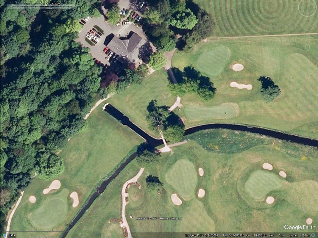
The Whittington tunnel is described by Rennison as being 3 miles in length, parallel and south of the Ryal tunnel, The western entrance to the tunnel is however unclear. Rennison says its western end is fed by a pipe from Hallington so there is probably nothing to see on the ground. The eastern end could be the water outlet located just west of the Golf Club-house at Matfen Hall as this joins the River Pont also used further downstream by water from the Ryal outlet.
Compressed air drilling equipment greatly aided the comstruction of the new tunnel although a third shaft was sunk later between Matfen and the eastern of the two original shafts to provide an additional two faces
The Whittington tunnel is described by Rennison as being 3 miles in length, parallel and south of the Ryal tunnel, The western entrance to the tunnel is however unclear. Rennison says its western end is fed by a pipe from Hallington so there is probably nothing to see on the ground. The eastern end could be the water outlet located just west of the Golf Club-house at Matfen Hall as this joins the River Pont also used further downstream by water from the Ryal outlet.
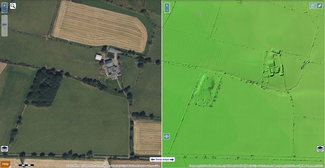
Satellite & LIDAR (DSM 1m) views of location of eastern shaft of Whittington tunnel near Delight. NLS side-by-side (2023)
All Saints' Church in Ryal has a plaque commemorating four workmen & five children or infants who died during the construction of Whittington tunnel and aqueduct works between 1901-1905. There are more details on the Find a Grave website.
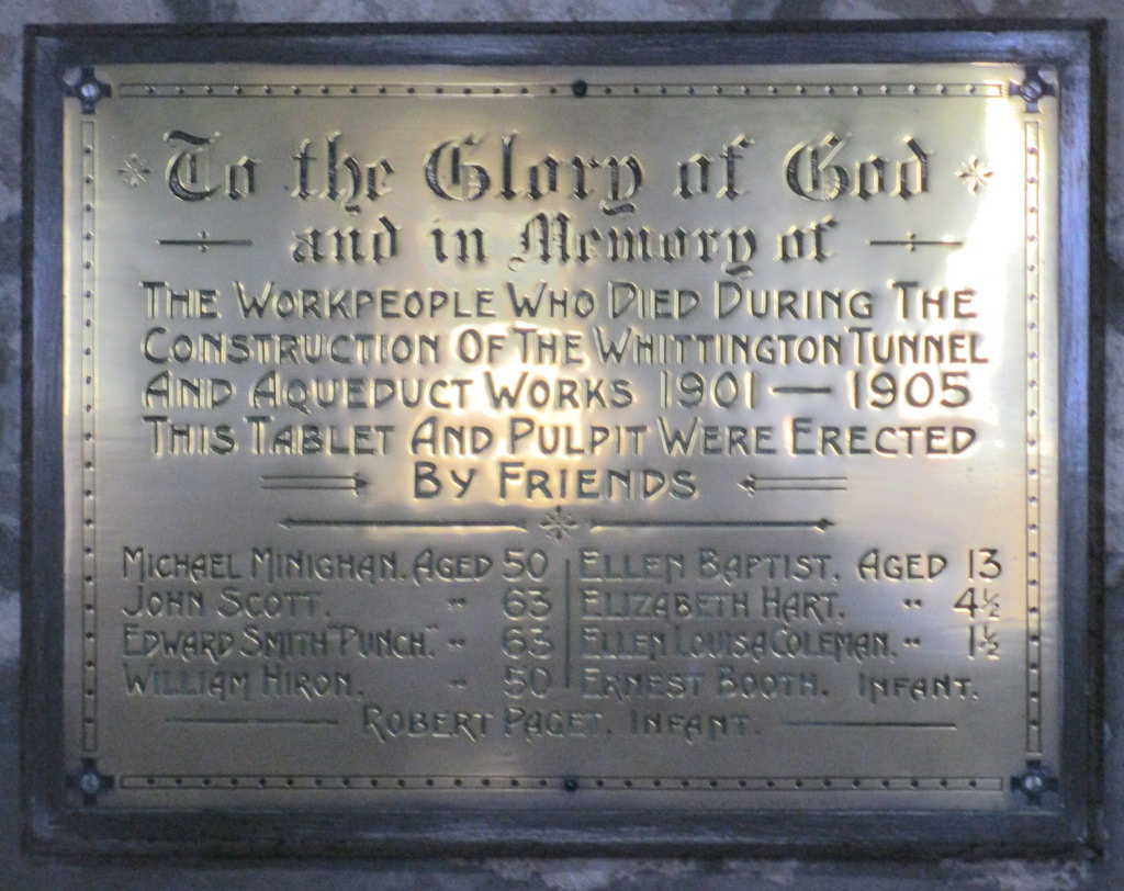
Plaque in All Saints' Church, Ryal commemorating workmen & children who died during the construction of Whittington tunnel and aqueduct works 1901-1905.
The Hexham Courant reported on 04 April 1903 that an epidemic of smallpox continued to rage among the residents of the huts belonging to the Newcastle and Gateshead Water Company at Matfen. This probably accounts for the infant deaths on the Ryal church memorial.
On 25 April 1903 the epidemic had reached the Catcleugh Waterworks from where two cases of smallpox were notified. They are stated to have been imported from Matfen. In response, about 400 navvies at the works were vaccinated.
On 25 April 1903 the epidemic had reached the Catcleugh Waterworks from where two cases of smallpox were notified. They are stated to have been imported from Matfen. In response, about 400 navvies at the works were vaccinated.
As shown below, many of the spoil heaps around the Ryal tunnel shafts are identified on Historic England's Aerial Archaeology Mapping Explorer.
Between some of these sites straight banks are also recorded, and interpreted as tramways, perhaps here built locally to aid transport of materials to and from the minor road (course of the Devil's Causeway Roman Road).
Further details are recorded as Monument No: 1458128
On the excerpt below, the spoil heap of the Grindstonelaw shaft of the Whittington tunnel can also be seen (Monument No: 1458178) but not the one near Delight. However, there appears to be no trace of the narrow-gauge railway that was run westwards along the line of the tunnel and reported by Rennison.
Screen capture (2023) from Historic England's Aerial Archaeology Mapping Explorer showing shafts and possible tramways.
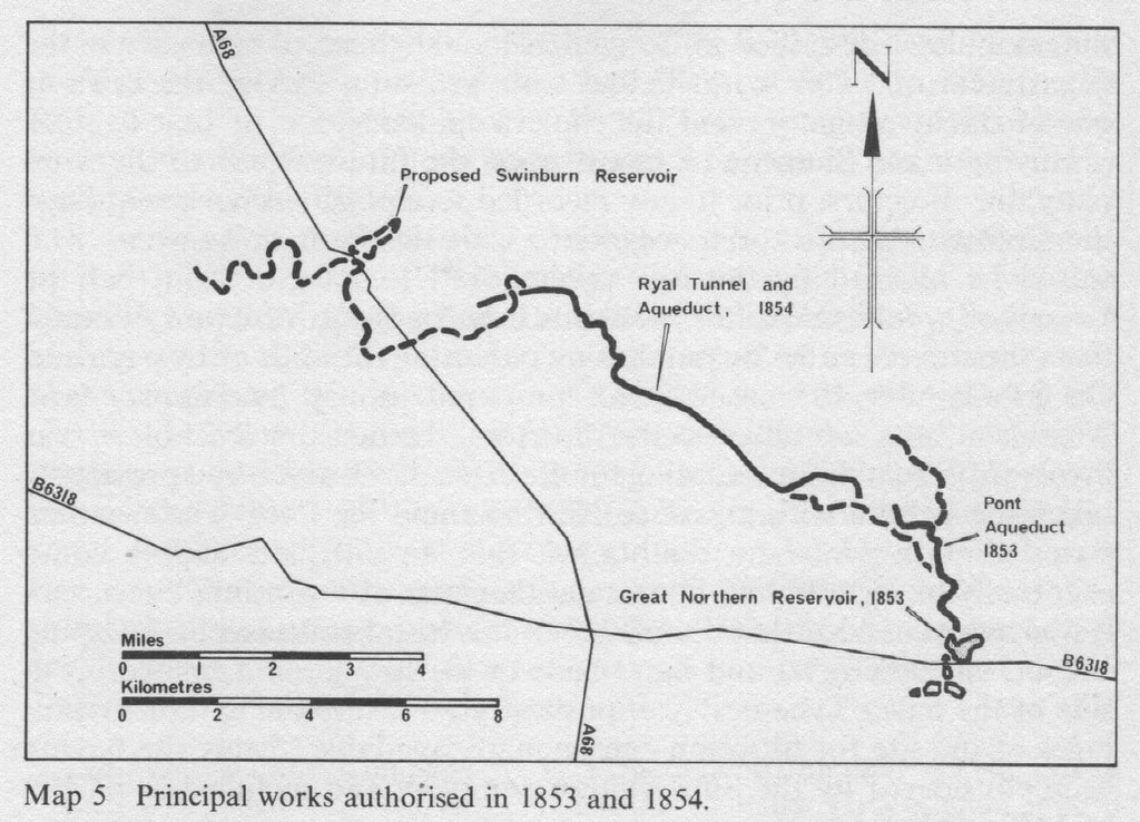
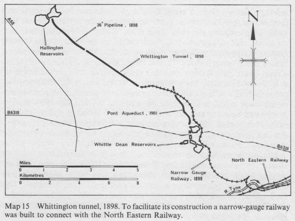
Below I have attempted to overlay my map of the tunnel shafts and water-courses (the first in the blog) with Rennison's large scale plans (Map 5 & Map 15 shown in the Timeline section). As they had to be scaled and slightly rotated to fit, the result is far from perfect.
It does appear to show the course of the two parallel tunnels, a different outlet for the Whittington tunnel, and the course of the narrow-gauge railway built to serve that location in the parkland of Matfen Hall.
It does appear to show the course of the two parallel tunnels, a different outlet for the Whittington tunnel, and the course of the narrow-gauge railway built to serve that location in the parkland of Matfen Hall.

Timeline
Reference: R W Rennison (1979). Water to Tyneside. Newcastle & Gateshead Water Company.
1845-1863 Whittle Dean Water Company
1848
Construction of the original group of five reservoirs at Whittle Dean completed.
Water conveyed by a 24” pipeline to Newcastle (including that through Heddon to a reservoir at Throckley).
1853
Cholera epidemic in Newcastle.
Act of Parliament to enable company to obtain better water supply by aqueduct from River Pont.
1854
Act of Parliament allowing company to collect water by intercepting streams in the Hallington area and transport it to the main reservoirs at Whittle Dean by construction of an aqueduct. Work would include a 3,887 yard (3,554m) tunnel to allow water to flow by gravity through a ridge of higher land at Ryal.
1856
Tenders requested for construction of the tunnel.
Contract awarded to R Mains & Co. who quoted £7,101 for the work.
Arrangement made with the Duke of Northumberland for brickworks at Tongues.
1857
Work started on tunnel.
1858
Mains & Co. paid £500 for work done and second contract awarded to Roper & Smith who was working on 7 out of 12 shafts by March.
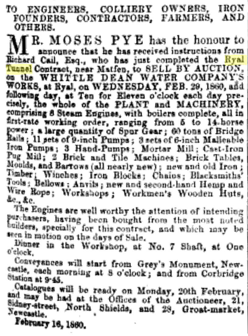
Only 1,471 yds of tunnel excavated by 1st December and works taken over by Richard Cail thought to be employing 200-300 workmen.
1859
Ryal Tunnel completed by 31st December.
1860
Sale of plant including 9 steam engines, 60 tons of bridge rails, 14 sets of pumps & 2 brick and tile-making machines
Land at Tongues Farm returned to agricultural use.
Workmen’s huts demolished and most shafts arched over & filled in.
Act of Parliament allowing company to collect water by intercepting streams in the Hallington area and transport it to the main reservoirs at Whittle Dean by construction of an aqueduct. Work would include a 3,887 yard (3,554m) tunnel to allow water to flow by gravity through a ridge of higher land at Ryal.
1856
Tenders requested for construction of the tunnel.
Contract awarded to R Mains & Co. who quoted £7,101 for the work.
Arrangement made with the Duke of Northumberland for brickworks at Tongues.
1857
Work started on tunnel.
1858
Mains & Co. paid £500 for work done and second contract awarded to Roper & Smith who was working on 7 out of 12 shafts by March.
Only 1,471 yds of tunnel excavated by 1st December and works taken over by Richard Cail thought to be employing 200-300 workmen.
1859
Ryal Tunnel completed by 31st December.
1860
Sale of plant including 9 steam engines, 60 tons of bridge rails, 14 sets of pumps & 2 brick and tile-making machines
Land at Tongues Farm returned to agricultural use.
Workmen’s huts demolished and most shafts arched over & filled in.
Railway Times, February 18th, 1860.
1863
Act of Parliament obtained for construction of reservoir at Hallington.
Company name changed to the Newcastle & Gateshead Water Company.
1863- Newcastle & Gateshead Water Company
1866
Act of Parliament obtained to extend time limit for construction of Hallington Reservoir
1869
Work started on construction of Hallington Reservoir
Construction aided by a narrow gauge railway to transport stone 3 miles from Moot Law Quarry
Locomotive obtained from Black, Hawthorn & Co. of Gateshead
1872
Work on Hallington Reservoir completed
Surplus plant and locomotive sold
Water transported from Hallington reservoir using the existing aqueduct and Ryal Tunnel (completed in 1859)
1877
Act of Parliament to authorise building reservoir at Little Swinburn and at the same time extended the time allowed to build West Hallington reservoir.
1879
Aqueduct between Little Swinburne and Hallington reservoirs commissioned
1880
Land was bought in 1880 for West Hallington Reservoir but construction did not start until Colt Crag reservoir, and the Swinburn reservoir were completed.
1884
Works began on West Hallington Reservoir using 60 navies.
Narrow gauge railway laid to transport stone from a quarry near Colt Crag Reservoir.
1889
West Hallington Reservoir filling
1892
Construction of pipeline from River Rede to Hallington. 23 of 27 miles completed by 1895.
1894
Act of Parliament allowing construction of a much enlarged Catcleugh Reservoir on River Rede
Using narrow gauge railway from Woodburn to Catcleugh
Hutted village for workmen at Catcleugh (1899: 331 men, 70 women, 94 children).
1898
Act of Parliament to improve carrying capacity of the tunnels and aqueducts.
Authorised construction of a new tunnel, 3 miles long, parallel to the Ryal tunnel, with its western end fed by a pipe from Hallington.
Also authorised narrow-gauge railway from Matfen to Wylam (part of which was already in operation for construction of filters at Whittle Dean).
Huts were erected on a site at eastern end of the tunnel, on land leased from Sir Edward Blackett. Here also were situated offices, a spoil heap, a canteen, and railway sidings for the narrow-gauge railway that was to run westwards along the line of the tunnel, and south-eastwards to Whittle Dean.
Arrangements were made to construct an aerial ropeway 600yds long crossing the River Tyne from Wylam (just west of the Wylam Pumping Station) to Prudhoe, where a terminal was constructed to link to a branch of the North Eastern Railway. The ropeway was supplied by Bullivant & Co. with 10 lattice steel towers some 28 feet high giving a clearance of 40 feet above river level, with a maximum span of 160 yeads. It was in place by 1903.
See advert below for Bullivant & Co. Ltd. taken from Grace's Guide.
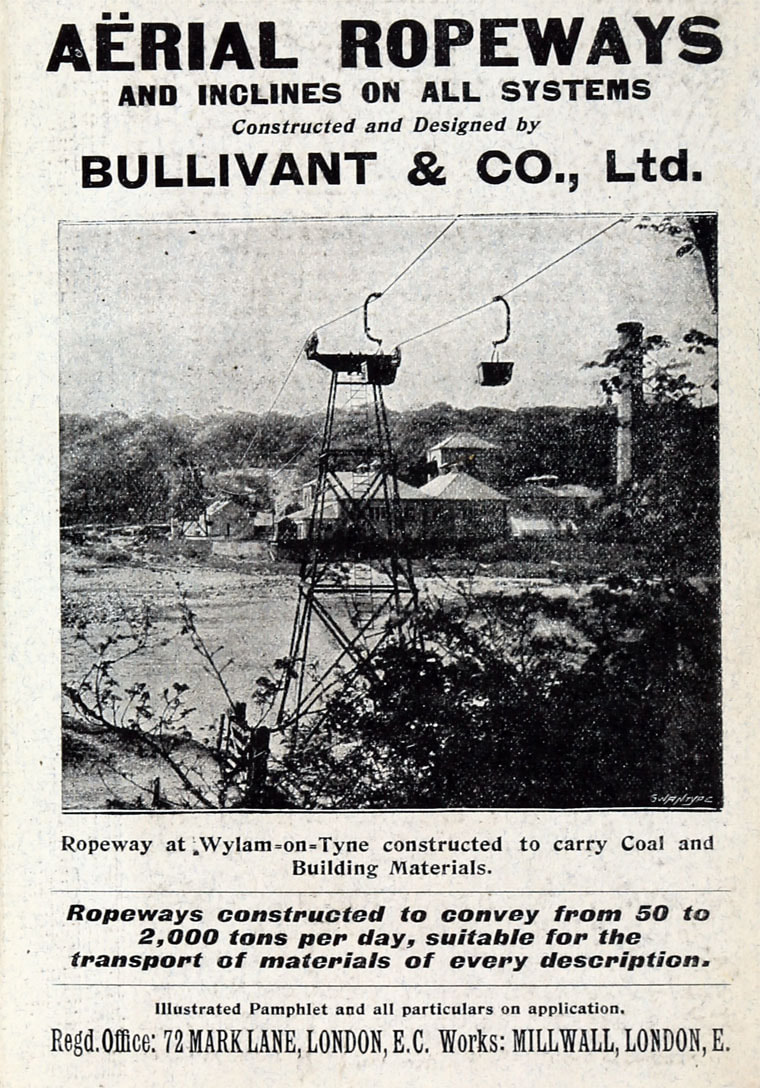
Aerial ropeway at Wylam. Bullivant & Co. advert (1906)
Unlike the earlier Ryal tunnel which had been constructed from 12 shafts, the new one was at first driven from only two, so providing six driving faces, mainly in rock.
Tunnel was lit by electricity and compressed air drilling equipment used.
A third shaft was later sunk between Matfen and the eastern of the two shafts.
One third of the tunnel completed by 1903.
1905
Whittington tunnel completed.
Catcleugh Reservoir completed.
“The completion of Catcleugh reservoir, with its associated works, brought to an end a period of archetypal Victorian enterprise, a period of sixty years during which the quantity of water supplied daily had increased thirty-fold and the capital expended by the Company had risen from £55,000 to £3.6m.” (Rennison 1979: 227).
Responsibility for the reservoirs and other infra-structure passed to the Northumbrian Water Authority in April 1974, as a result of the passing of the Water Act 1973. It then passed to Northumbrian Water when the water industry was privatised in 1989.
 RSS Feed
