
This year, I've spent a lot of time walking in the Cheviot Hills, exploring places I don't know or not been to for a long time. A recent walk on the England-Scotland Border east of Kirk Yetholm led me to another mystery.
What started it was a visit to see the Stob Stones (or Stanes to the Scots). Two large boulders, one standing, the other recumbent, east of the hillfort at Green Humbleton, and a stones throw (pun intended) from both the Pennine Way (high level route) and St Cuthbert's Way long distance footpaths. They are now firmly in Roxburghshire in Scotland, the Border boundary wall is to their east, but for a time were actually on the Border line.
What started it was a visit to see the Stob Stones (or Stanes to the Scots). Two large boulders, one standing, the other recumbent, east of the hillfort at Green Humbleton, and a stones throw (pun intended) from both the Pennine Way (high level route) and St Cuthbert's Way long distance footpaths. They are now firmly in Roxburghshire in Scotland, the Border boundary wall is to their east, but for a time were actually on the Border line.
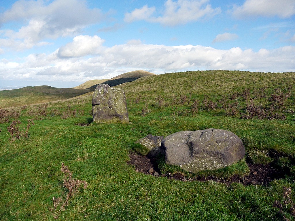
The Stob Stones. Photo by A Curtis (2012).
|
The Stob Stones. Photo by A Curtis (2012).
|
They are often referred to as standing stones, which has a prehistoric connotation. What do the archaeologist think?
The Royal Commission on the Ancient and Historical Monuments of Scotland. An inventory of the ancient and historical monuments of Roxburghshire (1956) records their visit to the stones in 1938. The record can be read on the excellent on-line resource known as Canmore.
However, they were not committing themselves to any opinion regarding their origin..
|
The "Stob Stones", two standing stones, are situated 230 yds W of the Border and over 1000ft OD. One still erect, measures 4 1/2ft wide at the base, narrowing to 3ft, by 1 1/2ft and 5 1/2ft high; there is evidence of stone packing at the base. The other now lies across its original bed 18ft to the S; it is 5ft long, 3ft wide and 2ft thick.
Both stones are of native porphyry and are locally called the "Gypsy Stobs" from the tradition that the kings of the Yetholm gypsies were crowned here. Mack (J L Mack 1924) suggests that they are boundary marks, set up on the line of the Border; if this is correct they may be of early medieval date as this point is on the section of the Border that the English commissioners of 1222 regarded as fixed. |
A later visit by the RCAHMS in 1978 revealed no further information. As well as the gypsy lore, the stones are still used as the destination for the annual ride out from Kirk Yetholm. They have always had importance locally. There is some information on the Yetholm gypsies here.
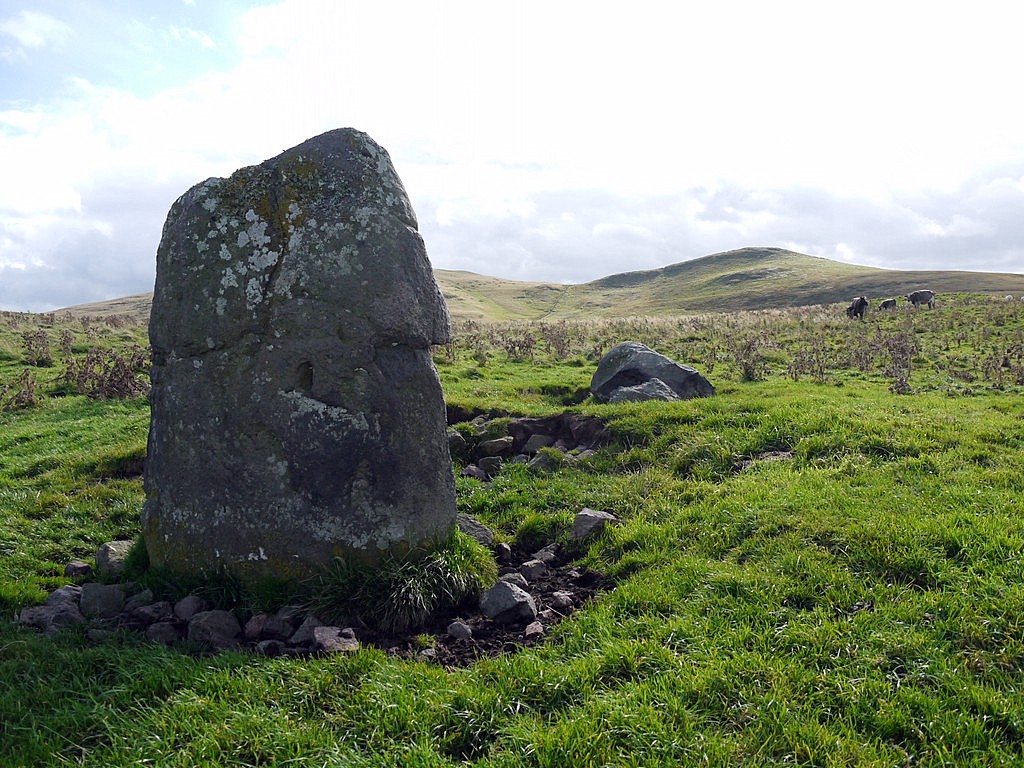
Standing stones west of White Hill. Photo by A Curtis (2012).
|
As I had walked that day from Hethpool in the Northumberland's College Valley, I was aware of the similarity between the Stob Stones and this site on White Hill. These stones are nowhere near the Border and the site has been interpreted as a likely Bronze Age burial mound.
|
If the large stones had originally been covered in a stone mound or cairn, then the stones must have been robbed for use elsewhere. The small stones packing the base are very similar to those around that of the erect Stob Stone.
|
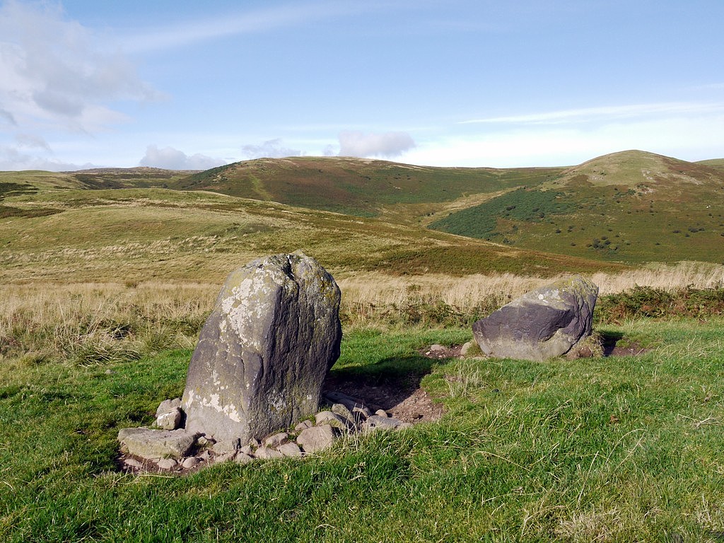
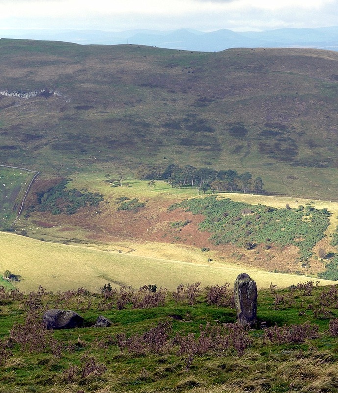
My walking book informed me that the standing Stob Stone is aligned on the distant Eildon Hills. It is not easy to claim an alignment only of one stone as it depends where you are standing or whether an edge of the stone can be used for sighting. The stone however, does have a 'nose' , which faces roughly in the right direction, as shown in the photo on the right. |
Supposed 'alignment' of the Stob Stones with the Eildon Hills. Photo by A Curtis (2012).
|
I can't say I'm particularly convinced by this alignment. For one thing, why would it require two stones? My photo does though show something quite interesting. If you line up the stone with Eildon North Hill, the little nick on the ridge of Staerough Hill above Halterburn also lies on the alignment. As this is almost due west, It made me wonder where the sun might set at the solstice. However, that's not the purpose of my blog and I don't think I can use that to prove a prehistoric origin.
A correspondent, Geoff Holland, who knows these hills well, kindly provided me with a little more about the Canmore reference to J L Mack.
In 1924, James Logan Mack, an Edinburgh lawyer and amateur historian, wrote a book entitled The Border Line from the Solway Firth to the North Sea, Along the Marches of Scotland and England. The edition most frequently found now is that published in 1926 by Oliver & Boyd (335pp, 119 illustrations by Donald Scott and others).
Mack's book remained the definitive account for many years. These Border lands have never been on the tourist trail. The broadcaster, Eric Robson produced a book called The Border Line in 2007, about his experiences following the same route, with much information about Mack and his writing.
Mack provides an illustration of the Stob Stones in Fig. 86, and on p. 267 tells us that
"... they were doubtless carried thither and erected to mark the boundary, in the early thirteenth century or even prior thereto".
Eric Robson, like me, thought them to be much older.
Mack goes on to discuss a linear earthwork of two, almost parallel banks each with a ditch on the downhill side, which starts just north of the Stob Stones, and runs north-east to join the line of the current Border, south of Eccles Cairn and the stream valley known as Humbleton Swyre. This can still be seen today.
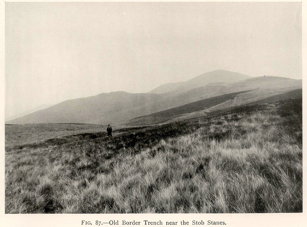
Fig. 87 - Old Border trench near the Stob Stanes. James Logan Mack (1924).
|
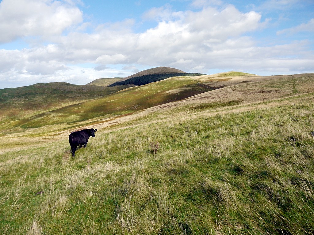
Old Border trench near the Stob Stones. A Curtis (2012).
|
As shown above, I had photographed the same feature on my first visit, from almost the same spot as Mr Mack, before I even knew of his work.
The cow in my photo is demonstrating one of the two ditches, as is the figure in his photo.The hill to the left is Burnt Humbleton (which carries the remains of a hillfort); in the background is Coldsmouth Hill, firmly in Northumberland, now rising above a forest plantation. The current Border runs along the base of this plantation, below Eccles Cairn, visible on the right..It is demarcated by a proper wall and fence through which the St Cuthbert's Way footpath now passes via a gate. The linear embankment crosses the head of HUmbleton Sike. Much of its course is clearly visible in aerial view.
The cow in my photo is demonstrating one of the two ditches, as is the figure in his photo.The hill to the left is Burnt Humbleton (which carries the remains of a hillfort); in the background is Coldsmouth Hill, firmly in Northumberland, now rising above a forest plantation. The current Border runs along the base of this plantation, below Eccles Cairn, visible on the right..It is demarcated by a proper wall and fence through which the St Cuthbert's Way footpath now passes via a gate. The linear embankment crosses the head of HUmbleton Sike. Much of its course is clearly visible in aerial view.
The linear earthworks on Stob Rig are described by the Canmore database here Link They say that two interrupted banks run nearly parallel for 300m along the hillside and that they are similar in situation and appearance to many others in the Cheviot area. Many of these so-called 'cross-dykes', often run across ridges and are associated with the old cross-Border tracks. They may have been built to control or constrain traffic although it is not known at what period they were constructed. This could be another interpretation here.
Mack (p267) however, identifies the linear embankment on Stob Rig with 'a dytche called the marche dyke' which existed in a survey in 1541-42. He describes a system of double dykes, leaving a strip of neutral territory between. This method was used, for example, at Scot's Dyke (part of the Western Marches), on parts of the former Border line north of Chew Green, and seems a reasonable explanation. The OS of 1:10,560 scale in 1863 shows this part of the Border line following a 'Track of Embankment' in a direction NNE-SSW, marked occasionally by 'piles of sods'. There is a change of direction away from this alignment north of the Stob Stones (a short section marked as undefined', then another at the Stones themselves.
A reasonable interpretation is that the ditches were cut to mark the Border line but the Stob Stanes were convenient markers already in situ, and of historic import. Interestingly, there is another linear embankment where the earlier Border line rejoined the current line at the col between White Law and Stob Rig.
John Barber (1999) considers the parallel earthworks acting solely as cross-routeway control, in this case controlling the two routes running from Kirk Yetholm to the Border that diverge just below the Stob Stones. They may well predate fixing of the Border line in Medieval times but as exiting features in the landscape may well have been used as markers to define its course.
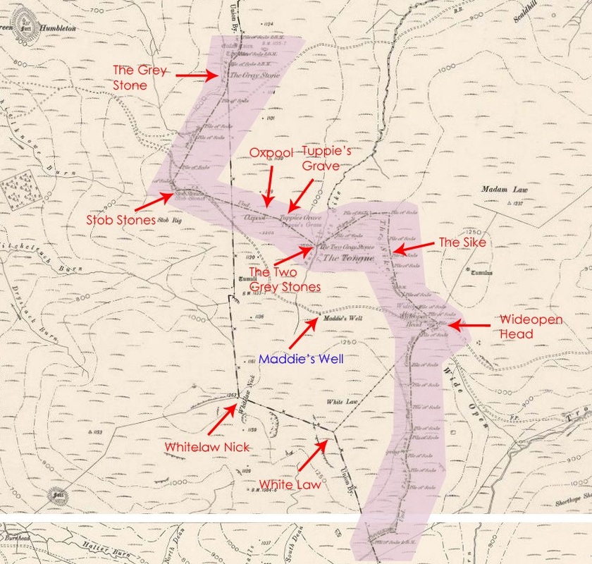
From the Stob Stones the Border line ran east, then south-east, on an undefined alignment incorporating Oxpool and Tuppies Grave among other (possibly pre-existing) features.
Among the many things I don't know, one is why the Border was eventually moved to its current line, east of this location, where it is shown on the OS Edition of 1899. At the same time, its former extension around Yetholm Common via Tuppie's Grave and Wideopen Head was also removed. Possibly it had something to do with a revision of County and Parish boundaries in the late 1800s.
Mack (p267) however, identifies the linear embankment on Stob Rig with 'a dytche called the marche dyke' which existed in a survey in 1541-42. He describes a system of double dykes, leaving a strip of neutral territory between. This method was used, for example, at Scot's Dyke (part of the Western Marches), on parts of the former Border line north of Chew Green, and seems a reasonable explanation. The OS of 1:10,560 scale in 1863 shows this part of the Border line following a 'Track of Embankment' in a direction NNE-SSW, marked occasionally by 'piles of sods'. There is a change of direction away from this alignment north of the Stob Stones (a short section marked as undefined', then another at the Stones themselves.
A reasonable interpretation is that the ditches were cut to mark the Border line but the Stob Stanes were convenient markers already in situ, and of historic import. Interestingly, there is another linear embankment where the earlier Border line rejoined the current line at the col between White Law and Stob Rig.
John Barber (1999) considers the parallel earthworks acting solely as cross-routeway control, in this case controlling the two routes running from Kirk Yetholm to the Border that diverge just below the Stob Stones. They may well predate fixing of the Border line in Medieval times but as exiting features in the landscape may well have been used as markers to define its course.
From the Stob Stones the Border line ran east, then south-east, on an undefined alignment incorporating Oxpool and Tuppies Grave among other (possibly pre-existing) features.
Among the many things I don't know, one is why the Border was eventually moved to its current line, east of this location, where it is shown on the OS Edition of 1899. At the same time, its former extension around Yetholm Common via Tuppie's Grave and Wideopen Head was also removed. Possibly it had something to do with a revision of County and Parish boundaries in the late 1800s.
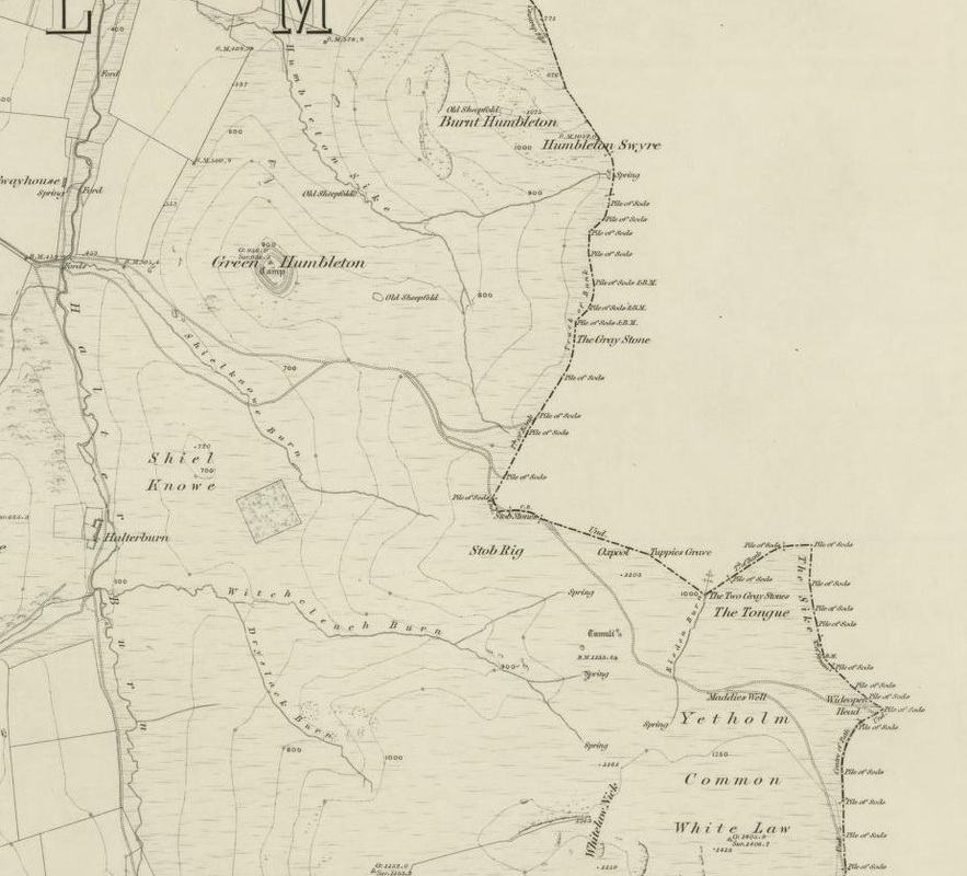
Section from OS 6 inch of Roxburghshire survey 1859, published 1863).
|
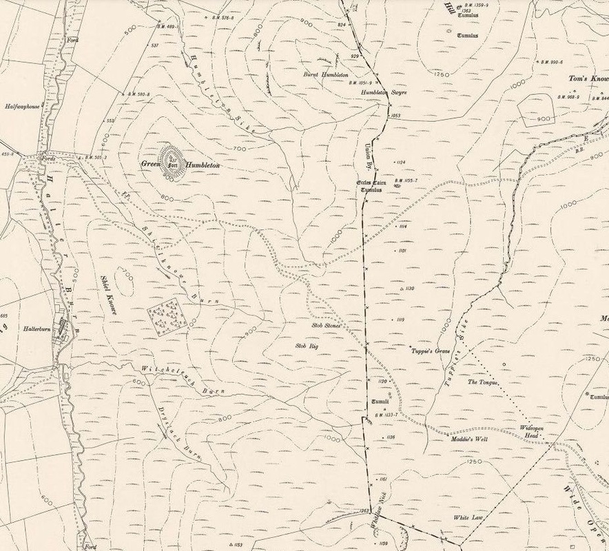
Section from OS 6 inch of Roxburghshire (revised 1896, published 1899).
|
Combined maps
My problems with the Stob Stanes and the Border line are these.
Why make the effort of lugging two huge boulders up here to mark the Border? Wouldn't it make more sense to define the Border using features already there? Wouldn't one stone have been sufficient?
Why doesn't the linear earthwork align on the stones? Again it appears to me that an existing earthwork may have been used to define the line, although its origin might still have been to define the Border much earlier in history. In 1862, the Ordnance Survey shows a bend just north-west of the Stob Stones marked by a Pile of Sods. Similarly to the east of the stones, much of its line is 'undefined' but uses an occasional named feature along its route, along with many such turf piles.
If someone has any of the answers, or a definitive explanation, please let me know.
As further illustration of the changes in the Border, I have roughly plotted the Border lines shown on the OS maps above onto a Google Map aerial view below. The lines are only approximate, and are an interpretation of the line taken by the Border. Several of the features plotted can not currently be identified on the ground.
View Yetholm Common in a larger map
Why did the line of the Border change in this area between 1862 and 1899, when the OS show it in its current location. I naively thought its line had been fixed much earlier. This is not just a parish or county boundary after all. The Border wall erected at that time now takes a very straight line along the edge of the watershed, and is now followed by the Pennine Way.
Yetholm Common ended up divided, and the new line ceded parts of the land to both England and Scotland, although a large part of the former Common ended up on the English side, perhaps as it always had been..
I'll discuss the divergence of the Border east of its current line, around Yetholm Common, in another blog soon.
Links
John Barber (1999) 'The Linear Earthworks of Southern Scotland'. Transactions of the Dumfriesshire and Galloway Natural History and Antiquarian Society, Ser. 3, Vol. 73, p. 63-164.
John Barber (1999) 'The Linear Earthworks of Southern Scotland'. Transactions of the Dumfriesshire and Galloway Natural History and Antiquarian Society, Ser. 3, Vol. 73, p. 63-164.
 RSS Feed
