
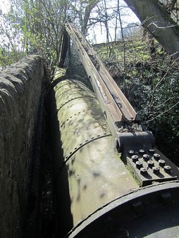
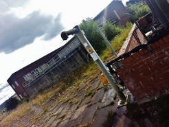
Large water pipe near Close Lea. Photo A Curtis (2011).
I've known about this huge pipe that crosses the former tramway of Killiebrigs Stone Quarry near to Close Lea below Heddon on the Wall village for many years and it always puzzled me. When was it laid, where does it go and is it still in use? I like a mystery waiting to be solved but I like it even more if someone tells me that I can't possibly write a blog about a water pipe! Well here we go.
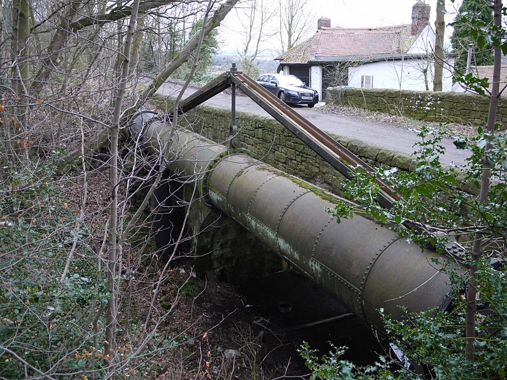
Large water pipe crossing quarry tramway at Close Lea. Photo A Curtis (2013).
The pipe is a huge diameter, riveted in cast-iron sections. It stands elevated on iron columns above the trackbed of the old tramway that runs down from Killiebrigs Quarry, its level just below the surface of the track that runs south form Heddon village, past Heddon Banks to the houses at Close Lea and on down to Close House. It must carry some volume and weight of water which may explain the interesting bracing struts on its top.
Like all good mysteries, this one comes in installments. I now have a good idea where it comes from, where it goes, who built it and when. All will be revealed here soon.
This location is the only one I know in the area where you can actually see the pipe so we can assume that it has been well buried at either end of the visible section below the quarry. I had always assumed that it was a water main presumably carrying water from west to east, possibly part of Newcastle's former water supply. I also believed that its line to the west would continue the line defined by the section shown but a recent discovery on Heddon Common proved that this is not the case, as it actually makes a dog-leg around the west edge of the quarry.
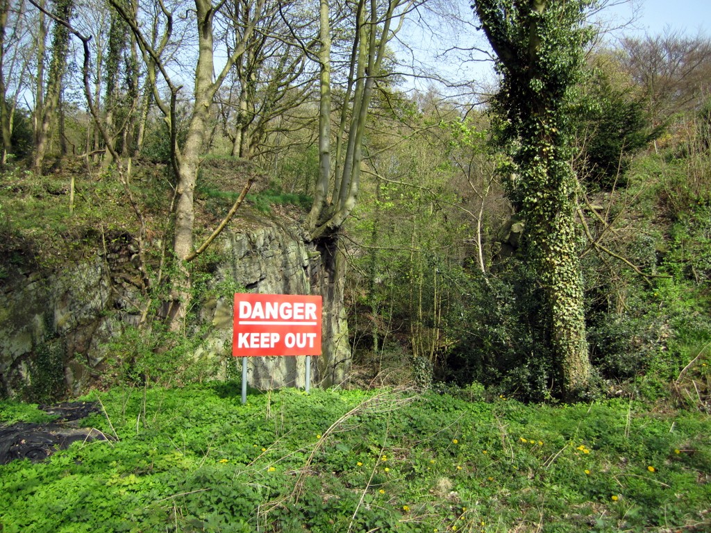
Please note that the disused quarry is on private land and not safe to explore. Everything can be seen from the track,
Please note that the disused quarry is on private land and not safe to explore. Everything can be seen from the track,
Killiebrigs Quarry (disused). Photo A Curtis (2011).
|
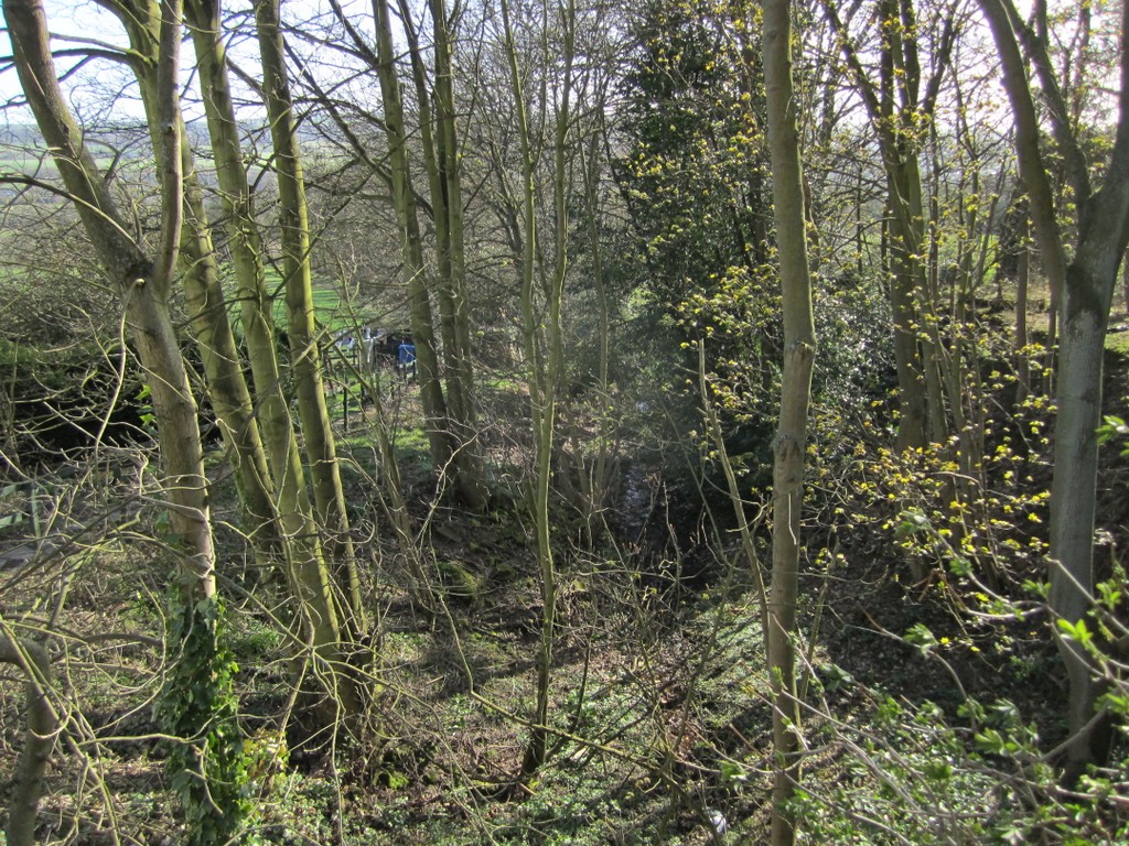
Line of former tramway running south from Killiebrigs Quarry. Photo A Curtis (2011).
|
To cut a long story a bit shorter for those of you desperate to know (the number of emails have been overwhelming) I will now reveal that this visible section of impressive pipe-work is part of the Throckley Aqueduct, built in 1866 by the Newcastle & Gateshead Water Company. It carried water from Whittle Dene Reservoir to the Throckley Filter Beds where for a long time it provided a major part of the water supply to a rapidly expanding Tyneside population. The Throckley Filters and the Aqueduct that supplied them are both now out of use, superseded by filters at Horsley and alternative water mains that run closer to the River Tyne.
In the next section I will reveal the geographical clues that allow you to trace the route of the aqueduct from west to east through the present countryside and also some elements of its history. There are still a few sections where I don't know its exact course underground as it is now well hidden. A major factor in its construction was the way it was contoured south of the the hill occupied by Heddon village, its whole course apparently designed to allow water to be transferred solely by gravity
In the next section I will reveal the geographical clues that allow you to trace the route of the aqueduct from west to east through the present countryside and also some elements of its history. There are still a few sections where I don't know its exact course underground as it is now well hidden. A major factor in its construction was the way it was contoured south of the the hill occupied by Heddon village, its whole course apparently designed to allow water to be transferred solely by gravity
View Whittle Dene to Throckley Aqueduct in a larger map
There is an article on the the Drinking Water Supply in Victorian Tyneside here. The water supply was insufficient for the population and the quality of the drinking water was poor. In addition to stand-pipes, water was brought into Newcastle from the River Tyne only a mile up stream, at Elswick. Water was also brought from reservoirs on the Town Moor and from a spring in Gateshead. Water from the springs was found to be polluted, possibly with seepage from the sewers, and the source on the Town Moor from cattle. Rain water that was collected in barrels or tanks was polluted by soot and impurities from the many industrial processes in the towns, and even when filtered several times, had a red stain and a disagreeable smell. Brackish water taken from the Tyne was often polluted and linked to outbreaks of cholera.
For the convenience of the poorer classes, the corporation had provided a number of public fountains or stand-pipes of which there were about 18 or 20 in different parts of the town: Gallowgate, Percy street, Darn-Crook, High Friar Street, Newgate Street, Big Market, High Bridge, head of The Side, Westgate Street, foot of Pilgrim Street, Manor Street, Sandgate West and East, St. Ann's Row, East Ballast Hills, St. Lawrence, New Green Market, Leazes near the Crescent, and one was being prepared in the Close.
The cost of water laid on by the Joint Stock Water Company was 18s. to 30s. for private houses. Manufacturies paid 3d. to 4d. for every 224 gallons. The poor paid one farthing for a tub or large pail full, four or five times more than the richer inhabitants of the town who could afford to have the water conveyed to their houses. The cost of water for the poorer classes was due to the water company having to pay for an attendant at each stand-pipe.
A major need for piped water within Newcastle was for fire-fighting, and it was a local insurance company, the Newcastle Fire Office, which provided some of the earliest water supply points. The Fire Office obtained much of its water from flooded colliery workings in the Coxlodge area, the water being pumped out by a windmill and run via a brick conduit to a reservoir on the Town Moor.
Better proposals led to the Whittle Dene Water Company being established in 1845. Reservoirs were planned at Whittle Dene above the village of Ovingham. These reservoirs, completed in 1848, at last gave Newcastle and Gateshead a steady, clean and regular supply of water. At this point the major works of the new company were completed and later described as ‘the greatest step with reference to the hydraulic supply of a Town that has been taken in the Kingdom’.
Following these early beginnings, the Newcastle and Gateshead Water Company came into being, gradually extending its area of supply and increasing its supply points. We now take clean and safe drinking water for granted, but as current construction by Northumbrian Water at the Horsley Water Treatment Works and the modernisation of pipelines across the area show, improvement is always a continuous necessity to provide for future supply.
Whittle Dene Reservoirs. Photo by A Curtis (2012).
|
Whittle Dene Reservoirs. Photo by A Curtis (2012).
|
So why do I think the pipe at Close Lea is part of an aqueduct from Whittle Dene to Throckley?
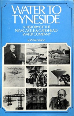
The first piece of evidence is in the classic: Water to Tyneside - A History of the Newcastle and Gateshead Water Company by Robert William Rennison (1979).
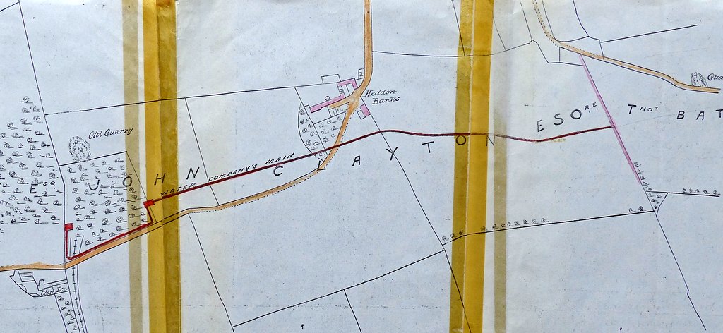
Map 9 on page 112, showing works undertaken between 1866 and 1877, is reproduced below.
The first piece of evidence is in the classic: Water to Tyneside - A History of the Newcastle and Gateshead Water Company by Robert William Rennison (1979).
Map 9 on page 112, showing works undertaken between 1866 and 1877, is reproduced below.
The first pipe-lines taking water from Whittle Dene to Newcastle shown in Rennison's book on earlier maps (e.g. Map 4, p.41) are all routed closer to the River Tyne, from a location near to where the later Wylam Pumping Station was established (in 1870). The line of the Throckley Aqueduct from Whittle Dene to Throckley Filters on Map 9, despite its small scale, bears a strong resemblance to the line defined by the points on my Google Map above.
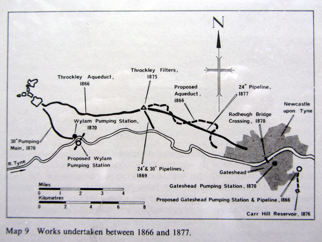
The Throckley Filters were only completed in 1875 and the Aqueduct originally terminated at a well from where 24" and 30" pipelines (domestic and trade respectively) continued the supply into Newcastle.
Line of Throckley Aqueduct and tunnel from Horsley Hill. Photo A Curtis (2013).
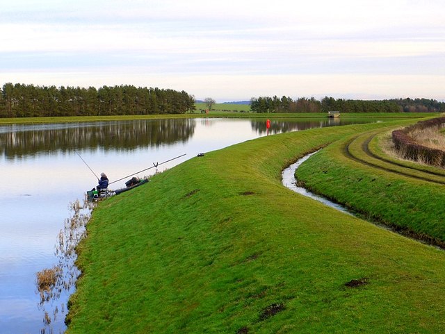
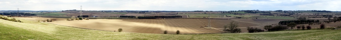
The aqueduct (blue on the map) starts below the dam of the Great Southern Reservoir at Whittle Dene ('Whittledean' on the old maps) and is an open water-course for some 2.25km (1.40miles). It passes under the Horsley to Harlow Hill minor road just east of the Water Works and runs east to just past North Dunslawholm where it enters a tunnel. Some sections of the water-course and tunnel are identified in the panorama above by narrow sections of coniferous plantation.
The tunnel which carries the aqueduct below Lousy Hill is shown on the map by a line of six air shafts (yellow on the map) and an internal short open section of aqueduct. The section at Bessy's Bog was to collapse in 1877 and had to be rebuilt. The end of the tunnel appears on aerial photographs to be marked by an open square shaft ( a well) surrounded by a high wall within a small area of woodland in the vicinity of the junction of March Burn and Howdene Burn.
I can find few clues to the underground course of the pipeline from here, but it must pass somewhere below the modern A69 dual carriageway and also the road south that leads to the crossroads north of Wylam. Just east of here, on the north side of the Hexham Road is a small waterworks building, shown on the maps as Well House. This is located close to a minor watercourse (a tributary of Rudchester Burn). My initial guess was that the pipeline would cross the Hexham Road at this point but further inspection at the stream east of Well House suggests that it probably continues underground along the north side of the Hexham Road, in front of the properties at Blakeley Hill, Houghton Moor and Bluebell Cottages.
How the pipeline crosses Rudchester Burn and its valley I am unsure, but two clues to its course may be an Air Shaft shown in Blakeley Plantation the north side of the Hexham Road on the 1920 OS Map, and the unusually wide grass verge beside the road that runs east of Bluebell Cottages.
A local correspondent (yes, I do have them) remembers a shaft in the field south-west of the Close House Lodge, now part of the new Golf Course. Just east of the driveway to Close House there is an embankment over a small valley west of Broomy Hill, now a fairway of the Golf Course. Old maps show that it may have just been an estate track, a continuation of one that runs through the woodland, but an inspection shaft east of the Plantation (on the new Golf Course), and a distinct terrace in the pasture west of Heddon Common, shows that it may mark the underground course the pipeline.
Nothing is visible of the pipe to the east of the quarry although part of its line can be determined on aerial photos. The course across a field south of Heddon Banks is indicated by a terrace in the slope and a possible inspection shaft by a field boundary. There is an inspection shaft, similar to the one on the Close House Golf Course, on the edge of a field north of Heddon Hall. Here it is flanked by two (now unused) iron gate posts of a traditional water works type. There is a disused air shaft shown on large scale maps in a small patch of woodland east of Station Road, close to the probably course of the pipeline, but this may instead refer to a disused mine shaft
I am unsure of the course of the pipeline as it approaches Throckley but Throckley Quarry east of Bank Top is still owned by the Water Company. On the south side of Hexham Road, opposite to the entrance to Throckley Filters, there is an uncovered valve assembly in a garden which may be where the pipeline crosses the road. A well built Valve House on the same side of the road on the corner with Coach Road may be the course of the outlet pipeline.
The disused quarry was used to store waste sludge, periodically removed from the filter beds. It was part of the original plan to build a reservoir at Throckley and also a ongoing aqueduct. However, originally only a well was actually built. Later, adjacent land was obtained and the filter beds constructed.
The disused quarry was used to store waste sludge, periodically removed from the filter beds. It was part of the original plan to build a reservoir at Throckley and also a ongoing aqueduct. However, originally only a well was actually built. Later, adjacent land was obtained and the filter beds constructed.
A small uncovered inspection shaft within trees and dense holly scrub on Heddon Common was an initial clue to the course of the pipeline. The Common was unlikely to have been wooded when the pipe-line was constructed. The dog-leg along the western edge of Killiebrigs Quarry has already been described. It passes close to the former location of the engine house and chimney that used to power the quarry tramway. It seems to indicate that this was a later alteration in the line taken by the water pipe, necessitated by opening of the quarry presumably sometime after 1866.
UPDATE: 27th May 2015
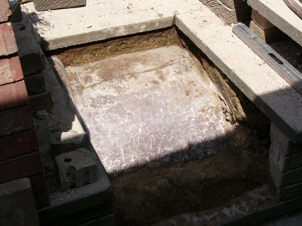
Just to dispell the myth that nobody reads my blogs, I can report that a recent correspondent who resides in one of the houses on Heddon Banks sent me the following photos of part of the cast-iron pipe which he had uncovered in his garden, along with an interesting plan of its course from his house deeds. Its line is much further north of the track than I had suspected and is quite close to the houses.
Just to dispell the myth that nobody reads my blogs, I can report that a recent correspondent who resides in one of the houses on Heddon Banks sent me the following photos of part of the cast-iron pipe which he had uncovered in his garden, along with an interesting plan of its course from his house deeds. Its line is much further north of the track than I had suspected and is quite close to the houses.
Copy of a drawing of the water pipe from Heddon Banks showing the dog-legs on both sides of the quarry. Plan from house deeds courtesy of Robin Brooks.
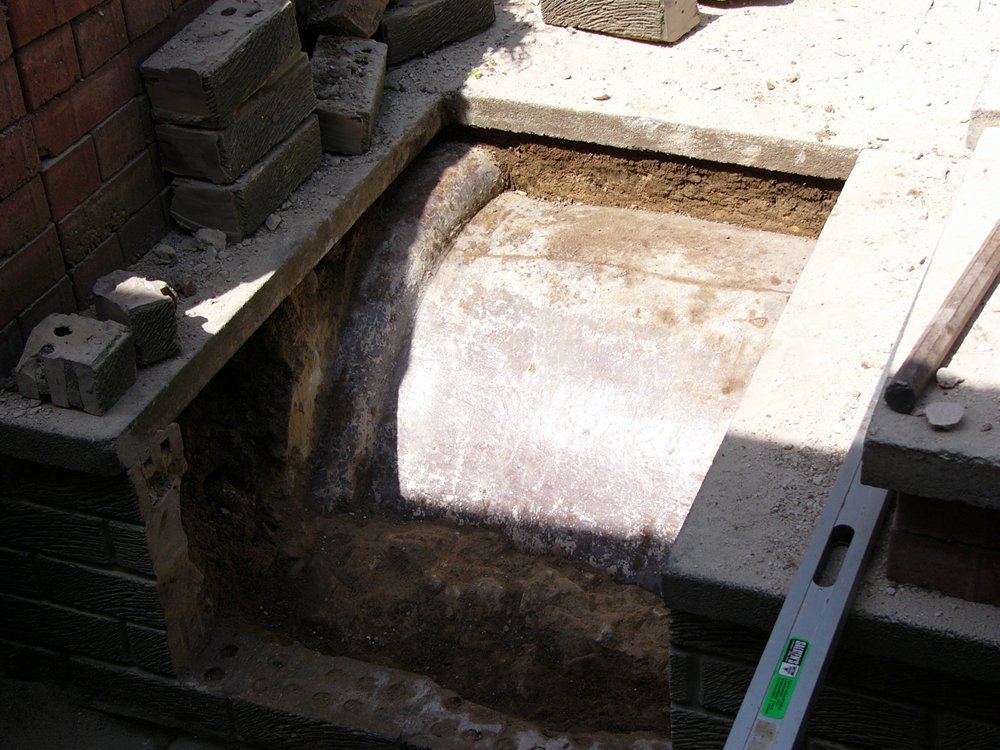
Throckley aqueduct pipe from Heddon Banks. Photo courtesy of Robin Brooks (2015).
|
Throckley aqueduct pipe from Heddon Banks. Photo courtesy of Robin Brooks (2015).
|
My final section here will be to cover some further elements of the history of the Throckley Aqueduct as provided by Robert Rennison.
Water to Tyneside - A History of the Newcastle and Gateshead Water Company by Robert William Rennison (1979) tells us the following about the Throckley Aqueduct.
An Act of Parliament was obtained in 1866, making provision, among other things, for the construction of an aqueduct from Whittle Dean via Throckley to Benwell, a project originally proposed by the engineer, John Bateman. The engineer responsible for construction was John Furness Tone, the Director of the Water Company at the time being Richard Burdon Sanderson.
Tenders were received for the aqueduct in April 1867 which was to be built in open cut, tunnel and pipe. The tender from John Simpson for £9,500 for the open aqueduct and tunnel was accepted, but he was later also entrusted with laying the pipes which the Company purchased directly. To avoid disputes with landowners, contracts were drawn up in advance and a policeman was provided by the contractor to prevent trespass. Tone decided to use earthenware pipes in view of the low pressures but they were very prone to failure and had eventually to be replaced by iron.
Tone suggested that a reservoir be built at Throckley and water taken onward from there by two lines of pipes, one 24" and one 30" (for trade and domestic supply respectively). It was subsequently decided to build only a well on the site. The initial construction was completed in February 1869.
Throckley Filters were constructed in 1875 on 3 acres of land adjacent to the well. 51,000 sq ft of slow sand filtration was supplied and expanded in 1877 with a similar area enabling treatment of 7.5 million gallons of water per day (mgd). In 1875, the domestic consumption was estimated at 6 mgd but would expand to 24 mgd by 1901 due to increased population, and the demand for baths and flushing toilets.
The massive brick retaining walls alongside Hexham Road at Throckley were subject to leakage and also collapse. In 1899 water leaked into the neighboring Methodist Chapel who were awarded £25 compensation. This chapel (now demolished) had been one of three built in the area by William Haswell Stephenson who was a Director of the Water Company between 1895 and 1918.
The massive brick retaining walls alongside Hexham Road at Throckley were subject to leakage and also collapse. In 1899 water leaked into the neighboring Methodist Chapel who were awarded £25 compensation. This chapel (now demolished) had been one of three built in the area by William Haswell Stephenson who was a Director of the Water Company between 1895 and 1918.
In 1884, the 7 filter beds at Throckley had become inadequate. They were cleaned by skimming the surface four times a year and removal of the sand only once every two years.
A report by Forster in 1888 looked at increasing the carrying capacity of the aqueduct and mains. He recommended construction of a further reservoir at Whittle Dean and replacement of the 42" earthenware pipes between Whittle Dean and Throckley by cast iron pipes. Although there were now 9 filters at Throckley, they were only capable of filtering some 8 mgd and the report recommended acquiring more land. This was refused by the landowner (Greenwich Hospital) and new filters were eventually built at Whittle Dean with water supplied to Newcastle by new mains.
A report by Forster in 1888 looked at increasing the carrying capacity of the aqueduct and mains. He recommended construction of a further reservoir at Whittle Dean and replacement of the 42" earthenware pipes between Whittle Dean and Throckley by cast iron pipes. Although there were now 9 filters at Throckley, they were only capable of filtering some 8 mgd and the report recommended acquiring more land. This was refused by the landowner (Greenwich Hospital) and new filters were eventually built at Whittle Dean with water supplied to Newcastle by new mains.
The earthenware pipes of the Throckley Aqueduct were replaced by 42" cast iron pipes in 1892.
Throckley Filters were repaired in 1906. By 1953, the slow sand filters at Throckley only had a capacity of 3.4 mgd and most of the supply was from Whittle Dene where slow sand filters constructed in 1897 were augmented by much more efficient pressure filters in 1925 and 1941.
In 1955, two of the filters at Throckley became horizontal flow sedimentation tanks for new rapid gravity filters which increased the output to 8 mgd.
Like everyone, I like to get safe, clean fresh water out of the tap. My strange interest in this pipe shows that you can also be interested in how it gets there and the clever Victorian engineers who devised the means to bring it to us.
I have to admit to secretly admire the so-called urban explorers who dare to record the inside of derelict and normally out-of-bounds locations. The Throckley Filter Beds was visited in July 2012 and recorded on 28 Days Later - the Urban Exploration Forum.
NWL Henderson Filters Throckley. Photo by Lottie on 28 Days Later (2012).
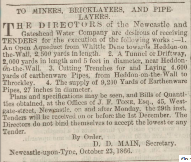
Request for tenders to build Throckley Aqueduct. Newcastle Guardian and Tyne Mercury - Saturday 03 November 1866 page 1
 RSS Feed
