
As part of my research for the Puffing Billy Festival this summer I decided to see what I could find out about the eastern end of the Wylam Waggonway. This was built to carry coal from Wylam Colliery to coal staiths on the River Tyne at Lemington.
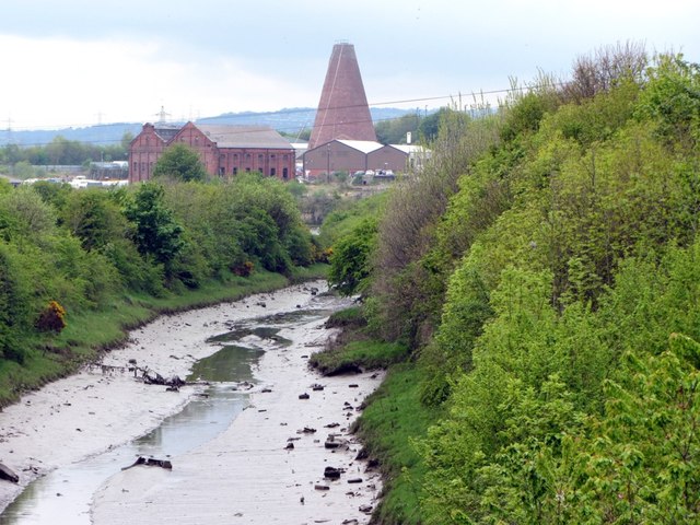
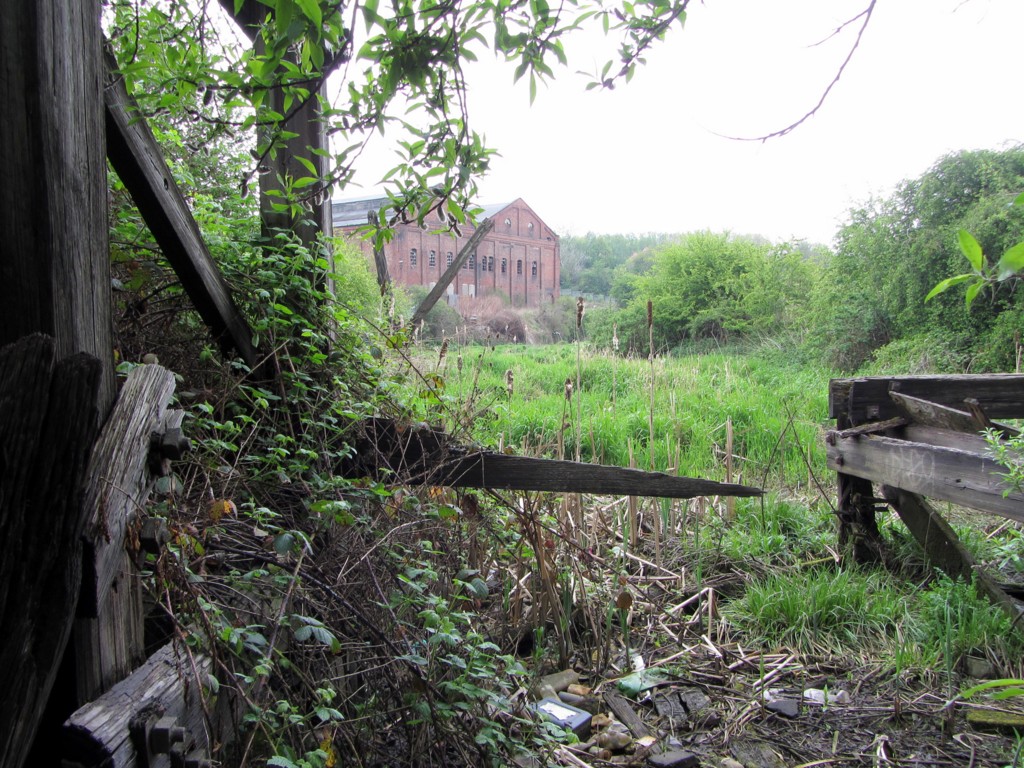
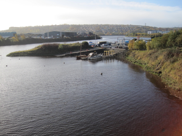
Lemington Gut - the former course of the River Tyne - from the new bridge at Kingfisher Boulevade. In the distance can be seen the cone of Lemington Glassworks and the remaining buildings of the former power station built on the site of Tyne Iron Works. Photo A Curtis (2013).
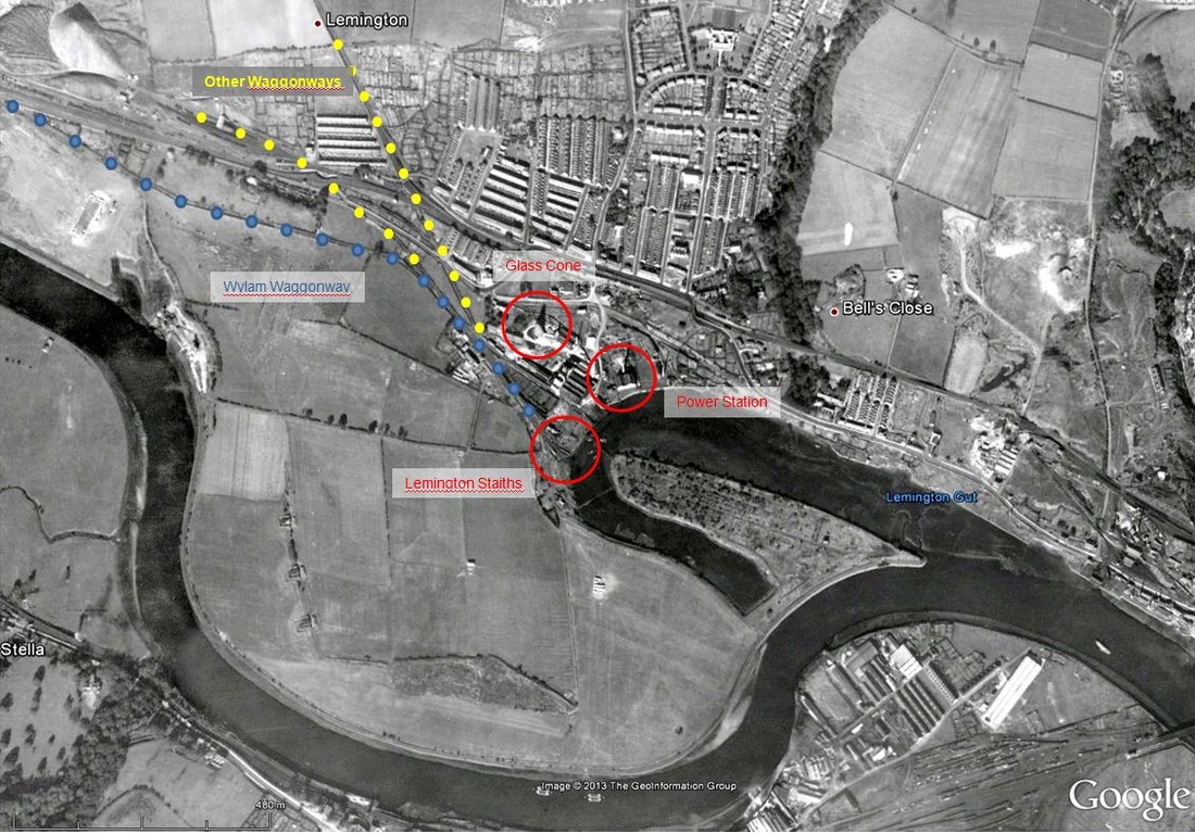
The Wylam Waggonway was built around 1748 for John Blackett owner of Wylam Colliery. It carried coal 5 miles from the colliery to staiths on the River Tyne at Lemington where it could be dropped into the holds of shallow-bottomed keel boats for transport down river where it was transfered to sea-going colliers. Lemington was then the west-most navigable point on the river before its course was improved and dredged. As well as that from Wylam Colliery, Lemington was the terminus of two other waggonways: Holywell Main & Greenwich Moor (Black Callerton) (1767), and Throckley & Walbottle (1751) which went to adjacent staiths.
Initially, the Wylam Waggonway was built with wooden rails, 3.5 inches wide and 4.5 inches deep attached to stone sleepers at 18 inch intervals, at a gauge of 5 feet 0.5 inches. Each loaded chaldron waggon was pulled by a single horse and needed one man as driver. They could make three trips every shift. The route was mainly level and ran alongside the public highway between Newburn and Wylam.
In 1808, the wooden rails were replaced by iron plate rails (for unflanged wheels) which enabled a single horse to pull two waggons instead of one.
The steam locomotives Puffing Billy & Wylam Dilly were built in 1813 and 1815 respectively. The engines themselves weighed over eight tons, and their tenders a further four tons but each could haul an average load of about 50 tons (8 loaded waggons) at a speed of nearly five m.p.h.
The engines were originally mounted on four wheels, but because their weight frequently broke the cast iron rails, they had to be remounted on eight wheels two or three years later. Both these locomotives worked the line until the early 1860s.
Between 1827 and 1830, the plate rails were replaced by 4 feet long cast-iron fish-bellied edge rails (for flanged wheels) attached by iron chairs pinned to the stone sleepers.
Wylam Colliery closed in 1868 and the waggonway fell into disuse. Much of its course, west of Newburn, was used for the Scotswood to North Wylam branch of the railway line built around 1876.
This line itself closed in 1966, the track removed in 1972, and the track-bed turned into a public bridleway and cycle-track.
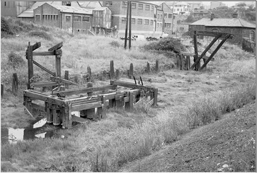
I didn't think there would be still anything to see at the end of the waggonways at Lemington as the land has had several changes of industrial use. I came across the left-hand photo below in the Beamish People's Collection, just titled 'Tyne Iron Works'. A search soon gave me the second. They show the remains of wooden structures in the right location still standing in the partly filled-in Lemington Gut in 1968.

Remains of the Tyne Iron Works at Lemington, 4th August 1968. Photo Beamish People's Collection Ref. NEG7604.
|
Remains of the Tyne Iron Works at Lemington, 4th August 1968. Photo Beamish People's Collection Ref. NEG7605.
|
|
Structural Images of the North East (SINE) has a photo taken in the same year and some further information.
|
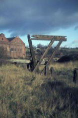
Lemington Staiths, 24 November 1968, on SINE. Stafford Linsley Collection Ref: 1389.
|
The fragmentary timber structures which survived when this image was made were probably the remains of the staiths owned by the Walbottle Coal Co. Ltd., and the Throckley Coal Co. Ltd.
Lemington was near the highest point on the north side of the Tyne suitable for coal staiths and consequently became an important point for coal shipping from quite an early date, and therefore for the convergence of waggonways. There were staiths here by 1640, and the main waggonways which served the eighteenth-century staiths, notably the Holywell Reins Way (1767), the Walbottle Moors Way (1781), the Wylam Way (1748) and the Throckley Way (1751), can still be traced. The last to remain in use were the Walbottle Staith of the Walbottle Coal Co. Ltd., and the Throckley Staith of the Throckley Coal Co. Ltd.
The river improvements of the 1880s by-passed the staiths and left this section of the river a backwater, (a new channel was cut across a large meander), but access to the staiths, and dredging of the old river bed, was continued while the staiths remained in use
A quick look at Google Earth showed me that the larger structure was still intact and I determined to go and find it. The photo below left shows the larger wooden structure, now without its upper member, standing below the substantial masonry wall that still lines the Gut. The right hand photo shows the lower wooden construction in the former river bed just to its south-west. Comparison with the right hand Beamish image above shows that scrub vegetation is now infilling this part of the Gut.
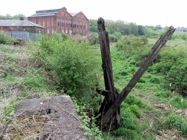
Remains of Lemington Staiths. Photo A Curtis (2013).
Remains of Lemington Staiths. Photo A Curtis (2013).
|
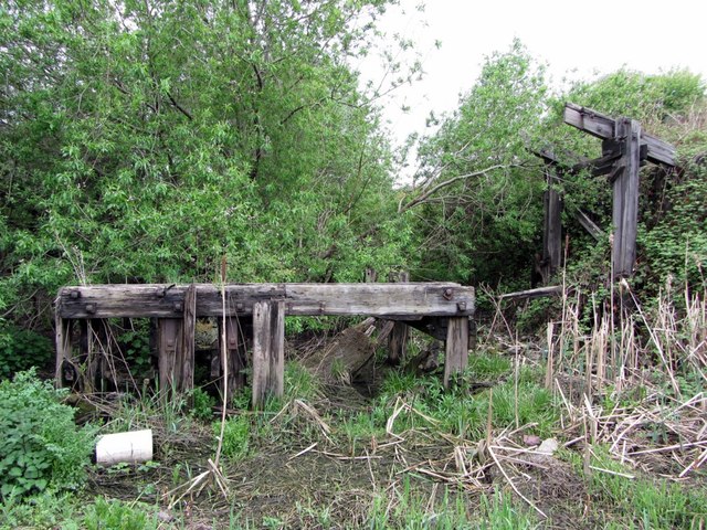
Remains of Lemington Staiths. Photo A Curtis (2013).
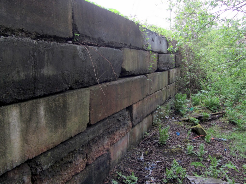
Old quayside near Lemington Staiths. Photo A Curtis (2013).
|
I do not know when these structures were built but they may be of a similar age to Dunston Staiths, further down river. These were constructed in stages from1893 to 1903 from 13"x13" pitch pine, jointed with bolts and straps. The Dunston Staiths were the last working timber staiths on the Tyne and closed in 1980. I don't know when the staiths at Lemington were last used, but the 1952 1:2,500 OS Map records both staiths and the nearby footbridge as 'disused'.
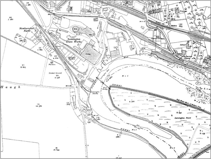
The OS map from 1859 below shows the Lemington coal staiths at the end of the waggonways. The large meander of the River Tyne here would later be cut off to form Lemington Gut after the river course was straightened by the Tyne Improvement Commissioners in 1876. Lemington Point at this time referred to the western end of the flat land on the south bank. The staiths lie on the inner bend of the meander on the east end of flat land known as Newburn Haugh. Just south of the staiths buildings is a property named 'Holland'.
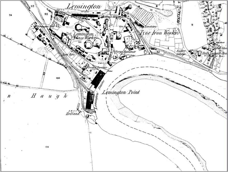
OS 1:2,500 (1859)
Between the staiths and the Glassworks is a public house named 'Doctor Syntax'. Several pubs in the area were given this name after a successful race horse of the 1820s. The name was derived from a British cartoon schoolmaster drawn by Thomas Rowlandson to illustrate poems by William Combe, published in Ackerman's Political Magazine between 1809 and 1811, and in book form in 1812. In 'Dr Syntax in Search of the Picturesque' the character visits the Lake District.
Only a single cone (built c1787) has been preserved from the former Glassworks. It has been described as one of the most important industrial monuments in the North East. There are further details here. Glass manufacture continued on the site until 1882 when the land was leased to Spencer’s Iron Works.
Little now remains of John Spencer & Sons Iron Works apart from the almost derelict single storey manager's house and offices, close to the staiths, which dates from c1830. The brick Power Station was built on the site in 1903 for the Newcastle and District Electric Lighting Company, later used to power the trams, and as a substation.
An illustration of the former Lemington Point published in 1867 is shown below. The rowing race was the World Professional Sculling Championship - between Henry Kelley of Putney and Robert Chambers of Newcastle held on 6th May 1867. Starting at the Tyne Bridge, Kelley beat Chambers in a time of 31 mins 47 secs. Prior to this date, Harry Clasper frequently raced here.
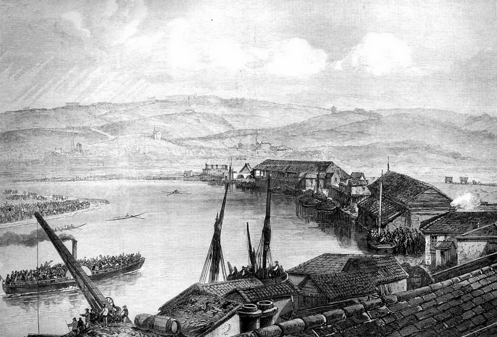
The Great Boat Race of 1867 at Newcastle upon Tyne – finish at Lemington Point. The Illustrated London News, May 18th 1867.
The staiths are presumably on the right bank of what would later become the Gut, and two waggons can be seen approaching them on a waggonway from the extreme right.
The furthest away large wooden building is probably that shown in the engraving below left taken from the article on The Montagu Family of East Denton Hall by Les Turnbull who describes it as being of the Holywell Colliery Staith at Lemington.
The furthest away large wooden building is probably that shown in the engraving below left taken from the article on The Montagu Family of East Denton Hall by Les Turnbull who describes it as being of the Holywell Colliery Staith at Lemington.
The large wooden structure was to protect the coal from weathering which reduced its price at market. The coal was then ferried by keel boats, which each carried eight chaldron (about 20 ton), from the staith to the sea-going ships moored at Shields near the mouth of the river. These larger vessels – generally between two and three hundred tons burthen – were unable to pass beyond the bridge at Newcastle; and most captains preferred to moor at Shields rather than tackle the moving sandbanks in the river.
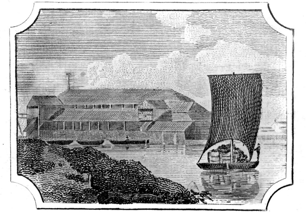
Holywell Colliery Staith at Lemington. Image from NEIMME.
|
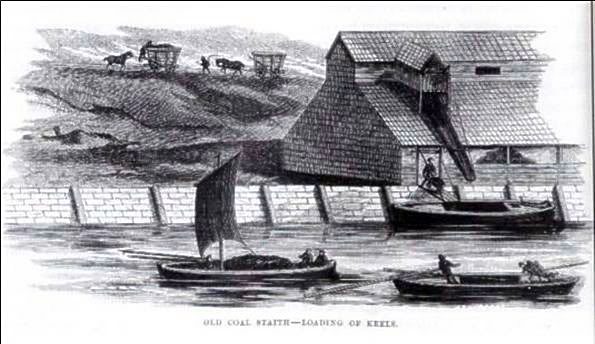
Old coal staith - loading of the keels c1800.
|
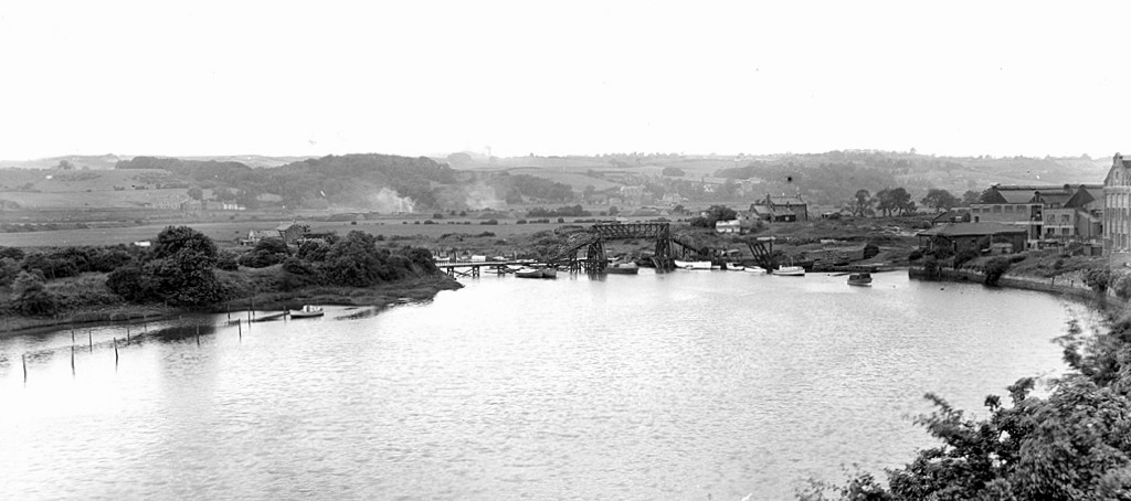
The 1936 map (below) shows some of the staiths still in use, the cut-off but still tidal Lemington Gut and had to be regularly dredged to prevent it silting up. There is a footbridge across the channel to the flat land of Lemington Point, now almost an island with only a narrow neck of reclaimed river bed joining it to Newburn Haugh.
OS 1:2,500 (1936)
The island at Lemington Point was locally known as 'Canary Island' during World War I when there was a munitions factory there, operated by Armstrong-Whitworth. It was so called because of the effect some of the explosives used (probably picric acid) had on the skins and hair of the workers (mainly women). The postcard photograph below shows the island connected by a footbridge to Newburn Haugh.
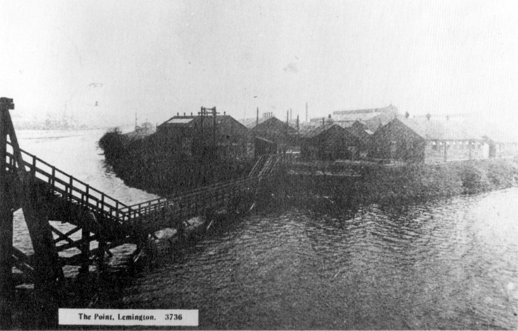
Munitions works at Lemington Point c.1920.
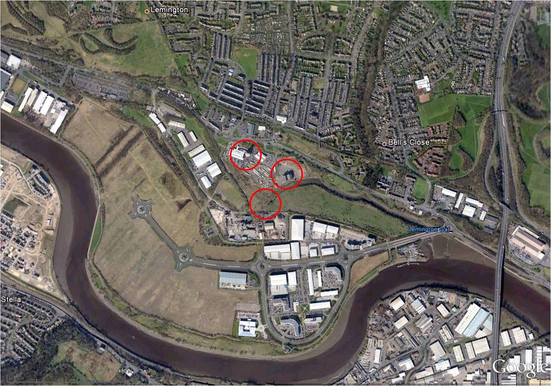
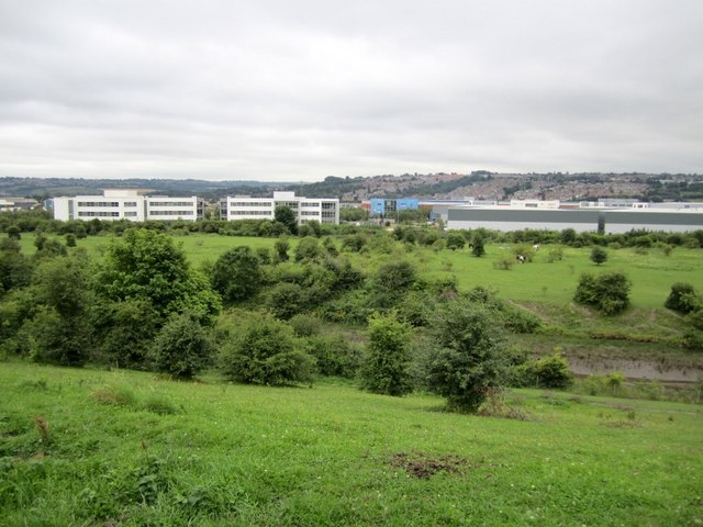
The land was reclaimed after World War II and in 1958 the Anglo Great Lakes Corporation Ltd. built a plant for the conversion of carbon into graphite for use in the nuclear industry. The plant continued operating until the early 1990s and was subsequently demolished, along with the neighboring Stella North power station. The two adjoining sites are currently being redeveloped as an industrial/business park.
Google Earth 1945 aerial photo.
|
Google Earth 2012 aerial photo.
|
Comparison of the 1945 photo shown above with the current image on Google Earth shows that the fields between the business park and the Gut are all land that has been reclaimed from the former river channel.
View of Lemington Gut by F Frith c1950. Newcastle Libraries Collection Ref. 056686.
The photo of Lemington Gut taken by Francis Frith c1950 (Ref: L179005) shows the Power Station and Tyne Iron Works Manager's House on the extreme right. The island at Lemington Point is connected by a footbridge which appears to have been constructed to allow passage of large boats through a limited channel near the shore. The coal staiths have gone but the Gut is still used for mooring of small, presumably pleasure, boats.
Today, we know Lemington Point as the promontory of land that sticks out east into the current course of the river, just upstream of the entrance to the Gut which is now spanned by a new bridge that leads to Newburn Riverside Business Park.
Boatyard at Lemington Point.Photo by Les Hull (2010).
|
View over Lemington Gut. Photo by A Curtis (2010).
|
The Railway Museum in Wylam's Falcon Centre has a photo of the disused Lemington Staiths taken in 1955. The caption says it shows the staiths that were last in use by the Throckley Colliery, adjacent and similar to those which served the Wylam Colliery waggonway.
Having now visited the derelict, semi-reclaimed area that lies at Lemington Staiths and the Gut it was nice to find a student architect's plans shortlisted in a 2012 competition held by RIBA North East.
In Symphonic Backwater, Otis Murdoch describes a restaurant and visitor centre forming part of a journey along the Lemington Gut.
He describes how, "An interactive sculptural boardwalk connects a series of places along this backwater out into the Tyne".
There are some more details on his website and much more in his book.
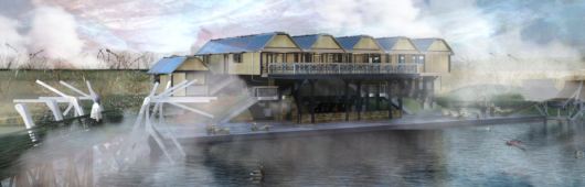
Symphonic Backwater / Otis Murdoch : Newcastle upon Tyne. RIBA North East Forgotten Spaces shortlisted 2012.
Now wouldn't that be a fitting tribute for such a historical and important location?
Links
Where Railways Were Born by Philip R B Brooks (1975)
Lemington & Newburn Heritage
Lemington Centre Factsheet
Northumberland & Newcastle Society - Lemington Glass Works
The Gut is Great by John Taberham (St James Heritage Group
Where Railways Were Born by Philip R B Brooks (1975)
Lemington & Newburn Heritage
Lemington Centre Factsheet
Northumberland & Newcastle Society - Lemington Glass Works
The Gut is Great by John Taberham (St James Heritage Group
UPDATE (23/02/2024)
A talk on Canary Island & the Lemington Canaries by John Taberham for the St James' Heritage & Environment Group.
World War ! at Home (BBC): Lemington - Canary Island.
A talk on Canary Island & the Lemington Canaries by John Taberham for the St James' Heritage & Environment Group.
World War ! at Home (BBC): Lemington - Canary Island.
 THE WOMEN'S WORK IN THE WAR INDUSTRY, 1914-1918 © IWM (Q 110272)
 THE WOMEN'S WORK IN THE WAR INDUSTRY, 1914-1918 © IWM (Q 110273)
 RSS Feed
