
My friend, Les Turnbull, is conducting research at the Mining Institute on the work of the notable Colliery Engineer, William Brown who was based for time in Throckley. Every now and then he sends me interesting nuggets of information about our local waggonways that keep my spark of interest in that subject alive.
This time his message was:
This time his message was:
Recently, I was asked to comment upon a manuscript that was sent into the MI from a former pitman who was born in Throckley and I quote below an extract for your interest and comments.
‘A northern branch of the way was built to the Meadow Pit and ran through the old Throckley School location and the Hill Pit. The last section of the way was elevated probably to bridge the road at Meadow Pit. A fairly large embankment was constructed which is still in existence north of the Hill Pit site’.
The ww was excavated in the grounds of Throckley School but only soil marks indicating the sleepers and rails were found. This is the first I’ve heard about an embankment and I wondered whether you have come across it during your first work.
The waggonway in question is shown on the plans of Throckley shown below.
 A Plan of Throckley 'dated back 150 years from 1863' (NRO 536.1) | 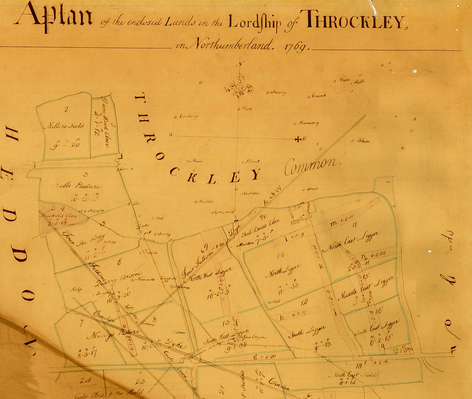 A Plan of Throckley 1769 (NRO 536.2) |
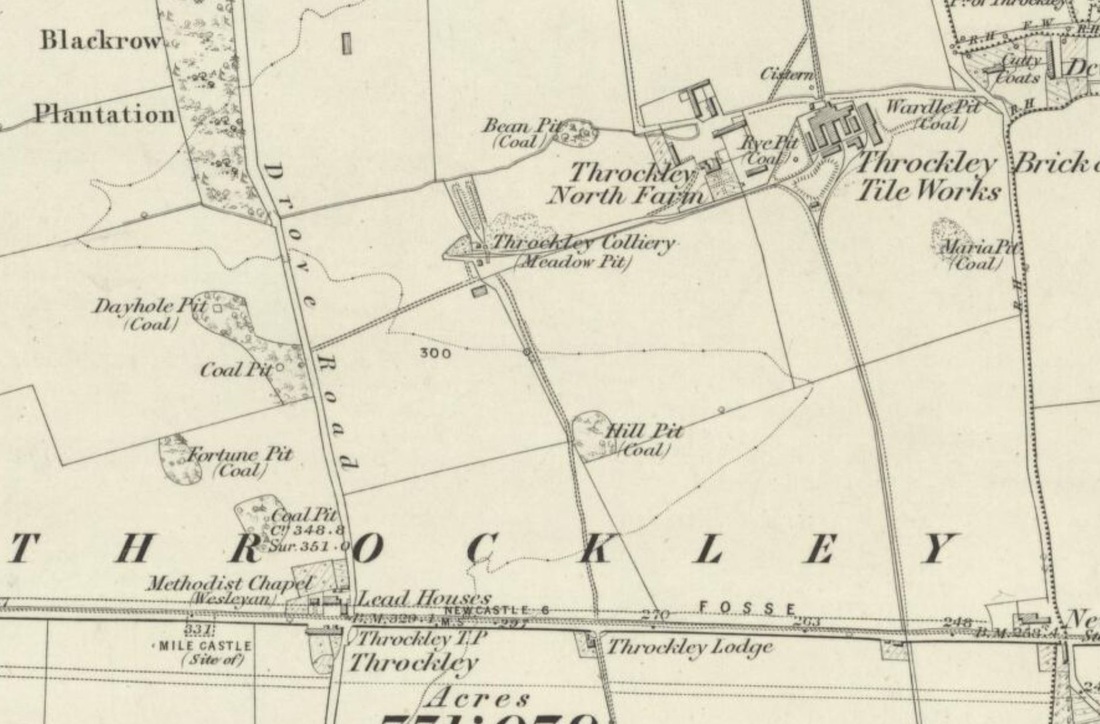
OS six-inch map (1865)
The earlier plan (left), although unlikely to be anywhere as early as 1713 as suggested, shows a waggonway crossing the Military Road (which was only completed in the 1750s) from south-east to north-west, west of the Newburn Road junction. In a big single field north of the road, named as 'West Leagure', it served two pits, Honey Pit and Meadow Pit, the latter situated just west of a group of buildings annotated as 'Browns House'.
Several pits are also shown in 'Maddies Pasture' west of Drove Road and in 'Quarry Field' to its north, but no waggonways are shown serving them. On an plan from Alnwick Castle dated 1755, a waggonway is shown, parallel to and on the south side of the Military Road, branches heading north-west and south-west from a point close to the Drove Road junction.
On the 1769 plan, 'Leagure' has been subdived into four fields, 'Ligger'. A waggonway crosses the Military Road as above but on the north side, in 'South Ligger', it branches. One branch heads west past New Engine Pit in 'South West Ligger', then north-west, crossing the Drove Road, to Duke Pit, situated then just beyond the enclosed land on what was Throckley Common. The other branch runs to the north between 'North West Ligger' and 'North Ligger', where Hill Pit is shown, to Meadow Pit, then located in another enclosure named as 'Fell Bulls Close'.
At this time, Throckley village was located south of the Military Road at Bank Top, connected to its Common by the Drove Road.
The waggonway to Meadow Pit is also shown on 'A Plan of the Inclosed lands of Throckley' of 1781 (NRO ZAN M17/197/A/37). The waggonway is not shown on the 1st edition Ordnance Survey map of 1858 so was presumably out of use by this date.
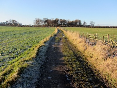
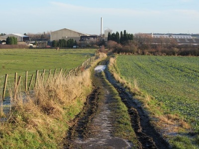
The 6" OS map (surveyed 1860, published 1865), from which an excert is shown above, shows the location of Meadow Pit now served by a waggonway from the east, connecting to the Throckley Colliery waggonway. Its route passed just south of Throckley North Farm, presumably on the alignment of the present bridleway. Meadow Pit is indicated as disused in the 1913 revision.
The alignment of the waggonway is still clearly visible in the line of the broad boundary which runs between the fields, on the line maintained by the slanting east boundary of the Throckley Filter Beds and the school grounds. The former site of Hill Pit shows as a small wood east of that alignment, just north of the school.
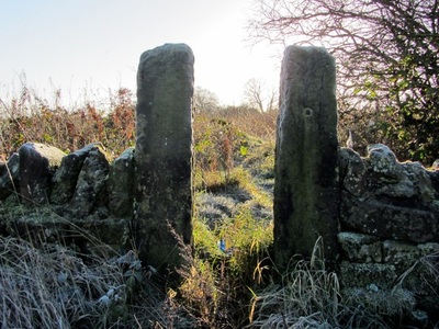
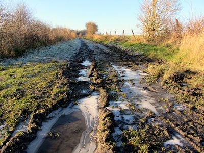
Meadow Pit was located in the field north of the track (bridleway) that leads from the Drove Road east to Throckley North Farm. The site of the pit has been completely reclaimed. The waggonway alignment south of this track is heavily overgrown but still shows evidence of embankment. There is no sign of a bridge. The stone gate-posts still standing where it meets the bridleway are explained by the track shown on the 6" map which leaves the Military Road opposite the former location of Throckley Lodge which stood on the corner of what is now the Coach Road.
Meadow Pit was located in the field north of the track (bridleway) that leads from the Drove Road east to Throckley North Farm. The site of the pit has been completely reclaimed. The waggonway alignment south of this track is heavily overgrown but still shows evidence of embankment. There is no sign of a bridge. The stone gate-posts still standing where it meets the bridleway are explained by the track shown on the 6" map which leaves the Military Road opposite the former location of Throckley Lodge which stood on the corner of what is now the Coach Road.
Archaeological investigation of the waggonway in the grounds of Throckley Middle School, Hexham Road between 2001 and 2003, described in the Tyne & Wear HER 1958.
An evaluation trench was cut across the line of the wagonway in July 2002. It was found to be of 3 phases.
The earliest phase was a low-lying trackbed only 0.45m below modern ground level, at least 2.30m wide, cut into the natural subsoil. There was no evidence of sleepers or rails. To the east of this was an upcast bank comprising of re-deposited natural soil. The bank was 0.40m high and was 2.60m wide. On the west was a ditch, 1.18m wide and 0.38m deep. It had been infilled with crushed coal when it went out of use. A single stakehole was found cut into the western side of the ditch, presumably representing a simple fenceline.
The second phase of the wagonway involved the infilling of the putative trackbed and western side of the bank and the levelling of the eastern side, to create a broad embankment at least 4.20m wide and 0.40m high. To the east, a broad shallow ditch was excavated, 2.30m wide and 0.20m deep. This too was filled with crushed coal when it went out of use.
The third phase re-defined and deepened the wagonway's eastern boundary ditch. The wagonway went out of use in the late 18th century when Honey and Hill pits were closed and the area reverted to agricultural land.
A subsequent watching brief found that the wagonway was multi-phase. Ten groups of sleeper impressions were recorded, representing a single track wagonway diverging into a fan of sidings leading to Hill Pit. Two phases of trackside ditches were recorded.
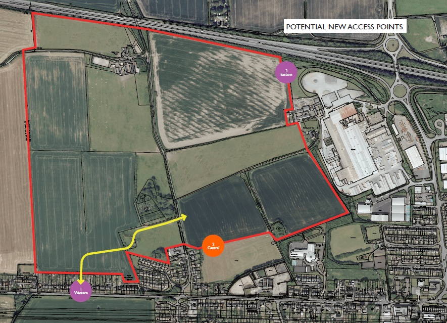
Proposed Throckley housing development
As of March 2015, two main sites relevant to this discussion have been proposed for housing development, both on Green Belt land. Details of both sites are in the 'Greenwich Hospital Throckley Masterplan'. The plan and details below are copied from the Save Throckley's Open Spaces website.
Site A is to the East of Drove Road where 550 homes are planned. This site is part of the ‘One Core Strategy’ and if planning permission is granted, work could commence as early as 2015. Site B is to the West of Drove Road where an additional 550 homes are proposed.
The plan below shows the extent of both developments. Note that the sites are bordered by the A69 to the North, Hexham Road to the South and the brickworks to the East. The first plan shows the three potential access points. No.1, shown in yellow below being the preferred option. This involves demolition of two existing houses on Hexham Road (said to be already in Greenwich Hospital ownership) to create a new road, crossing the Drove Road.
 RSS Feed
