
I quote the following story about one of the Upper Coquetdale landowners at the time of the Ordnance Survey in the early 1860s as it fits with a project on transcribing the OS Name Books for Northumberland that I am involved with at the moment.
The story is part of a short biography of Mr. Carr, in a regular section called Men of Mark ‘twirt Tyne & Tweed in The Monthly Chronicle of North-Country Lore and Legend Vol. 3 (1887-1891)’, p. 385-387.
You can read this, and other works during the life of Ralph Carr for yourself here.
RALPH CARR-ELLISON (1805-1884, originally Ralph Carr) was the eldest son of John Carr, Esq. of Dunston Hill and Hedgeley.
Mr. Carr, 'landowner, antiquary and naturalist', was one of the few men who ever made the Ordnance Survey officials admit an error in topographical nomenclature.
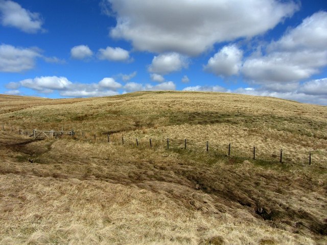
He owned the estate of Makenden at the head of Coquet, which runs up to what is locally known as "the Scotch Edge," where it "marches" with the property of the Duke of Roxburgh. In this district the boundary line between England and Scotland usually follows the water shed (or, as Dandie Dinmont [a character in Guy Mannering by Sir Walter Scott, 1815] expressed it, "the tap o' the hill, where win and water shears") between the valleys of the Teviot and Bowmont on the Scotch side, and those of the Rede, Coquet, and Breamish on the English.
But in various places the Scotch, like "Jock o' Dawston Cleugh", have encroached over the crest of the hills. These encroachments are usually marked on old maps as "batable" i.e., debatable ground. One such plot of "batable" land lay between the properties of Mr. Carr and the Duke of
Roxburgh, where, according to the contention of the Scotch, the march leaves the "tap o' the hills and bauds down by the Syke" in which the Coquet rises, thus cutting off the Plea Shank, which, like Dandie Dinmont's ground, "lying high and exposed, may feed a hogg [a sheep up to the age of one year; one yet to be sheared], or aiblins twa [perhaps two] in a gude year."
The spot is familiar to antiquaries, for the ancient Roman Camp, "Ad Fines", now known as Chew Green, lies just below it, and the Roman Road of Watling Street [Dere Street] here crosses the moors into Scotland.
For the sake of peace it had been arranged, at some former time, between the owners and occupiers, that half the Plea Shank should be pastured by each party. But when the Ordnance Survey came to be made, the Scotch revived their claim to the whole, and by some means or other contrived to win over those who were conducting the survey.
Little more was heard of the matter till the maps were issued, showing the boundary between England and Scotland drawn along the English side of the debatable ground. Then the English tenant was politely invited by his Scotch neighbour to keep his sheep on his own side of the new boundary.
On hearing this, Mr. Carr took steps to obtain all possible evidence from ancient maps and documents in the British Museum and elsewhere ; and instructed his tenant to turn a few sheep on to the disputed land in the meanwhile.
Meeting the farmer shortly afterwards, Mr. Carr said, "Well
Thompson, I suppose you put half-a-dozen sheep or so on
to the Plea Shank?" "Oh, no, sir," was the answer, "I just wysed on [used] fifty score!"
The result of Mr. Carr's investigations was to show that the land had been either English or debatable for centuries. This was brought to the notice of the officials in charge of the Ordnance Survey, the already issued maps were recalled and cancelled, and new ones restoring the Plea Shank to its
old " batable" character were published.
You can read this, and other works during the life of Ralph Carr for yourself here.
RALPH CARR-ELLISON (1805-1884, originally Ralph Carr) was the eldest son of John Carr, Esq. of Dunston Hill and Hedgeley.
Mr. Carr, 'landowner, antiquary and naturalist', was one of the few men who ever made the Ordnance Survey officials admit an error in topographical nomenclature.
He owned the estate of Makenden at the head of Coquet, which runs up to what is locally known as "the Scotch Edge," where it "marches" with the property of the Duke of Roxburgh. In this district the boundary line between England and Scotland usually follows the water shed (or, as Dandie Dinmont [a character in Guy Mannering by Sir Walter Scott, 1815] expressed it, "the tap o' the hill, where win and water shears") between the valleys of the Teviot and Bowmont on the Scotch side, and those of the Rede, Coquet, and Breamish on the English.
But in various places the Scotch, like "Jock o' Dawston Cleugh", have encroached over the crest of the hills. These encroachments are usually marked on old maps as "batable" i.e., debatable ground. One such plot of "batable" land lay between the properties of Mr. Carr and the Duke of
Roxburgh, where, according to the contention of the Scotch, the march leaves the "tap o' the hills and bauds down by the Syke" in which the Coquet rises, thus cutting off the Plea Shank, which, like Dandie Dinmont's ground, "lying high and exposed, may feed a hogg [a sheep up to the age of one year; one yet to be sheared], or aiblins twa [perhaps two] in a gude year."
The spot is familiar to antiquaries, for the ancient Roman Camp, "Ad Fines", now known as Chew Green, lies just below it, and the Roman Road of Watling Street [Dere Street] here crosses the moors into Scotland.
For the sake of peace it had been arranged, at some former time, between the owners and occupiers, that half the Plea Shank should be pastured by each party. But when the Ordnance Survey came to be made, the Scotch revived their claim to the whole, and by some means or other contrived to win over those who were conducting the survey.
Little more was heard of the matter till the maps were issued, showing the boundary between England and Scotland drawn along the English side of the debatable ground. Then the English tenant was politely invited by his Scotch neighbour to keep his sheep on his own side of the new boundary.
On hearing this, Mr. Carr took steps to obtain all possible evidence from ancient maps and documents in the British Museum and elsewhere ; and instructed his tenant to turn a few sheep on to the disputed land in the meanwhile.
Meeting the farmer shortly afterwards, Mr. Carr said, "Well
Thompson, I suppose you put half-a-dozen sheep or so on
to the Plea Shank?" "Oh, no, sir," was the answer, "I just wysed on [used] fifty score!"
The result of Mr. Carr's investigations was to show that the land had been either English or debatable for centuries. This was brought to the notice of the officials in charge of the Ordnance Survey, the already issued maps were recalled and cancelled, and new ones restoring the Plea Shank to its
old " batable" character were published.
The name 'Plea Shank' doesn't appear to have made it onto the 1st edition map although there is a 'Plea Knowe' on the border further away to the north-east, and another 'Plea Shank' near the line of Dere Street (formerly recorded as Watling Street) but on undisputedly Scottish land in the Borders, much further north.
 RSS Feed
