
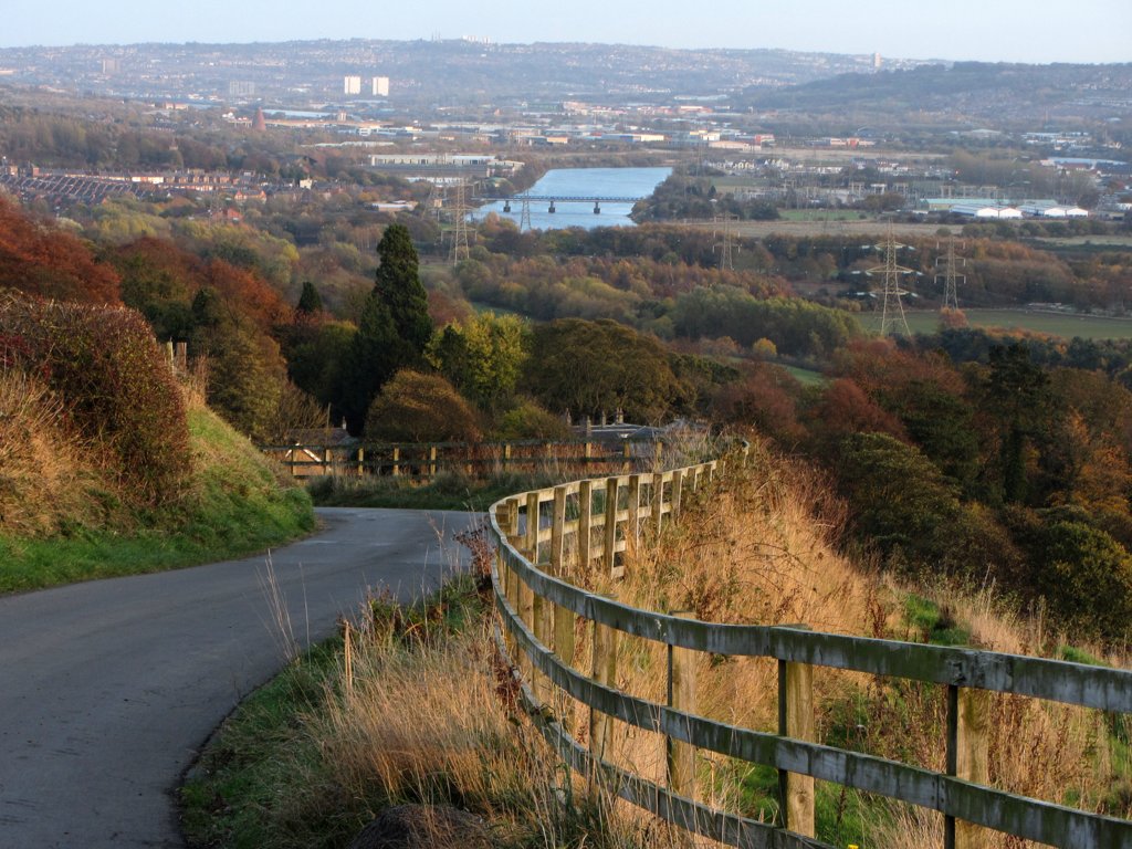
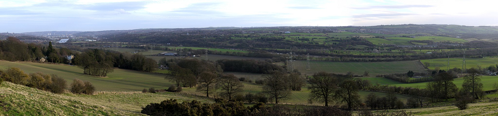
View east from Station Road, Heddon on the Wall. Photo A Curtis (2013).
One of the best things about Heddon on the Wall is the amazing view you get from many parts of the village.
Just how far can you see from Heddon, in what directions, and can you see the sea?
A recent post in the discussions of my favourite photo site, Geograph, asked the question about how to identify hill tops visible in photos. One of the answers was the panorama mapping tool website, heywhatsthat.
If St Andrew's Church had a steeple that would be the ideal viewing platform as the church stands on a prominent hill in the heart of the village. From ground level, though, it is surrounded by trees and other buildings, and views are limited.
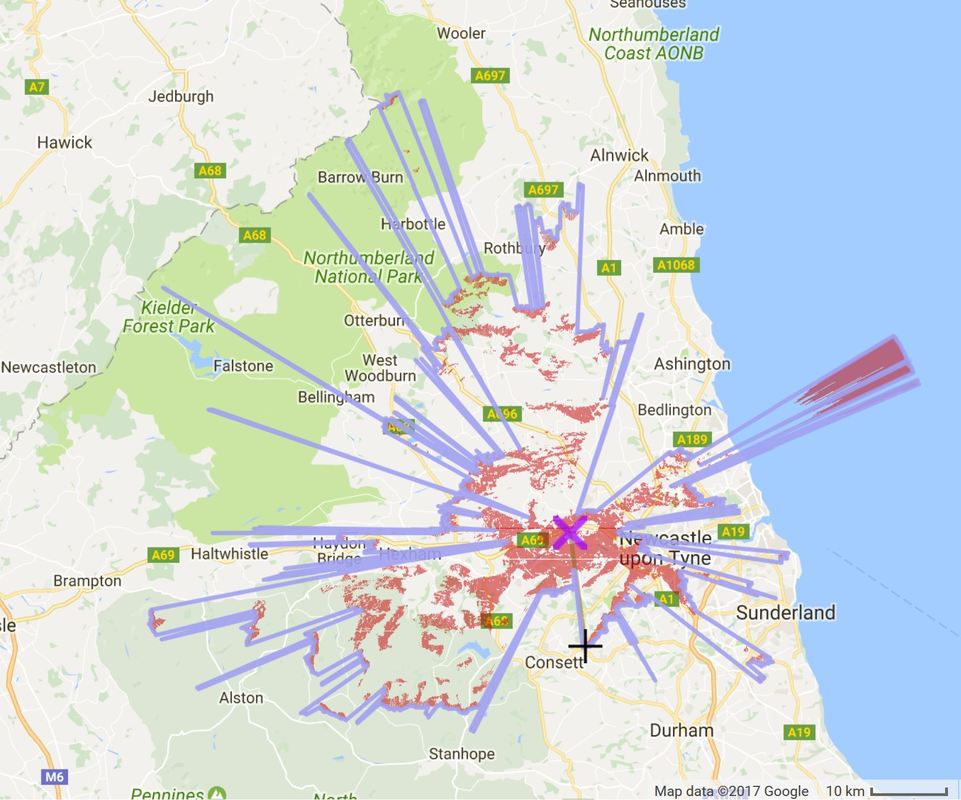
Google map showing the view from Heddon on the Wall (purple cross). Blue marks the horizon and red the areas that are visible. Output of panorama from www.heywhatsthat.com
The map above was generated from a panorama created from the highest part of Heddon, the seat above the old quarry on the west side of the village, behind the houses on Trajan Walk. The panorama can be explored in full detail using the following link: Heddon panorama.
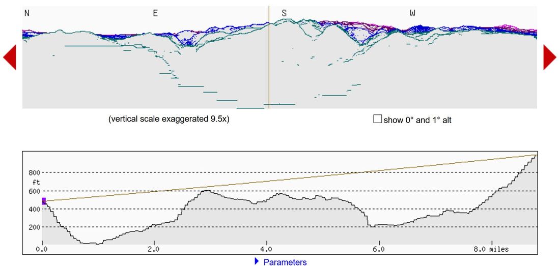
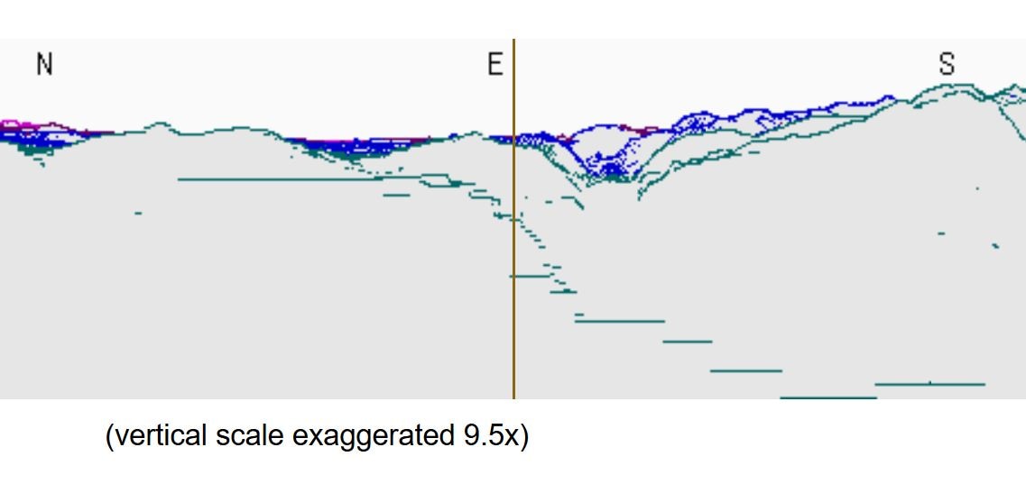
360 degree panorama from Heddon on the Wall and profile of view to Pontop Pike (shown by vertical line on top panel). From heywhatsthat.com panorama.
Pontop Pike is the site of our local TV transmitter station and has a hill-top situation between Dipton and Consett almost due south of Heddon on the far side of the Tyne valley. Its tall aerial is illuminated by red lights at night. It is the furthest we can see in that direction. Selection of the feature on the top panel provides the information that it is 9 miles from Heddon at a bearing of 172 degrees. For a few miles further west above the river, the view is more limited, extending only 5 miles to the high ridge used by the Lead Road.
Pontop Pike from Heddon on the Wall. Photo by A Curtis (2017).
If you are looking at night, the aerial lit by three, evenly spaced, brighter red lights to the left (east) of the fainter and irregularly lit aerial on Pontop Pike is the relay station mast on Blackmoor Hill located between Byermoor and Marley Hill (7 miles, 144 deg.)
The views to the south-west open out just west of the location of the Northumbria Gliding Club and the prominent little building (5 miles, 201 deg.) on the nearby hill top (National Grid Telemetry Building, Currock Hill). Just west on the same hill is a copse of trees that hides a water tower (5 miles, 204 deg.)
The views to the south-west open out just west of the location of the Northumbria Gliding Club and the prominent little building (5 miles, 201 deg.) on the nearby hill top (National Grid Telemetry Building, Currock Hill). Just west on the same hill is a copse of trees that hides a water tower (5 miles, 204 deg.)
Tyne Valley panorama south-east of Heddon on the Wall. Photo by A Curtis (2011).
To the north, the website panorama shows we can see 21 miles to the Simonside Hills (bearing 342 deg.), and just to the left, 35 miles to the Cheviot Hills (338 deg.), You need good atmospheric conditions to see that far; the best chance is a good day in winter when the distant hills are white with snow.
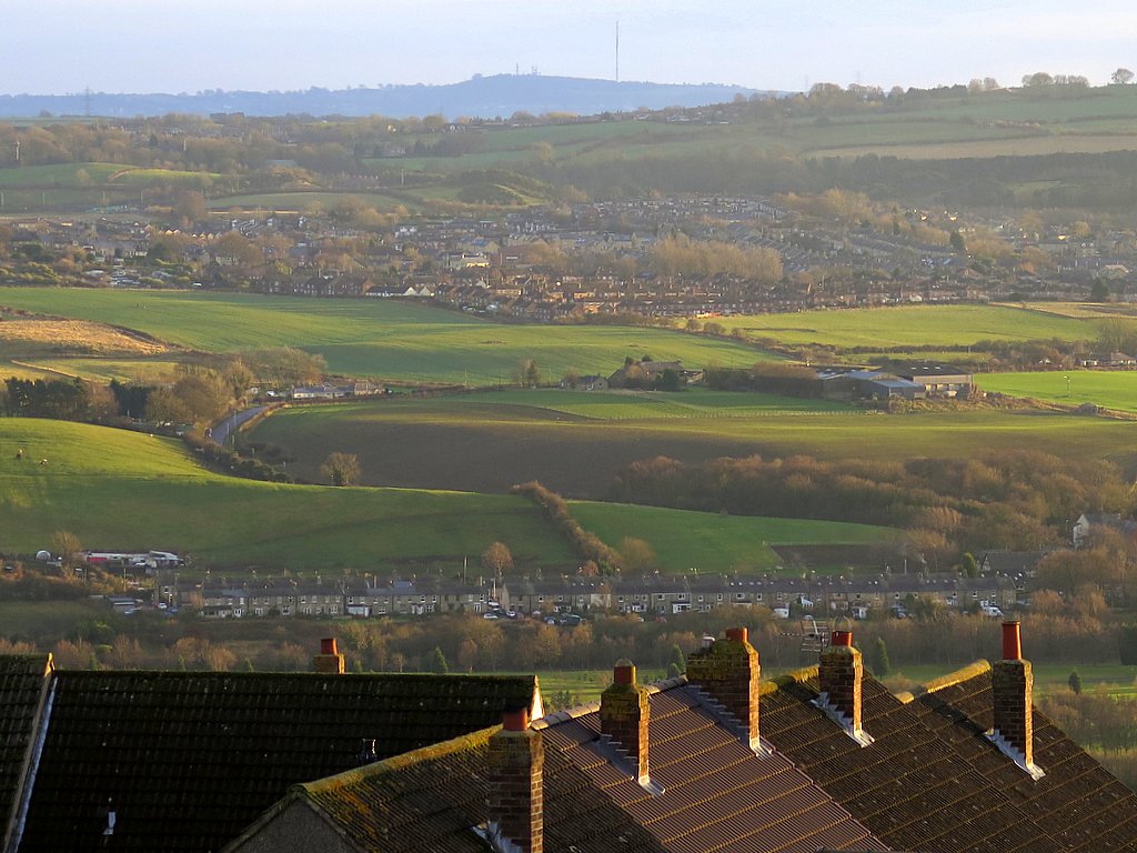
Heddon Laws above the A69. Photo A Curtis (2015).
To the NNE, Heddon Law (2 miles, 26 deg.), shown above, and the continuing high ground to the east, block any further view in that direction. The Law is topped by several large farm buildings, possibly a bronze age cairn, medieval beacon, a trig point, copse of trees, and a mobile phone mast disguised as another tree. It was the location of an encampment of the Scottish army before their victory at the Battle of Newburn Ford on 27th August 1640.
They liked the spot so much that they stayed here again in 1644 on their way to Corbridge, to confront the English cavalry during the Civil War. Perhaps the views were to their liking. Either that or the state of the campsite toilets.
However, slightly further to the east of that ridge, the view opens up again. On bearings between 58 and 67 deg. the panorama indicates we can see over Callerton, Woolsington, Brunswick, Wideopen to the sea just beyond Seaton Sluice, some 25 miles distant.
Views west are not so good, blocked by high ground along the line of the Military Road, the route of Hadrian's Wall. The BBC, in 1937, sited an AM trasmitter station near Beukley Farm (also known as Stagshaw) just off the A68 (9 miles, 287 deg.). Its tall aerial provides a convenient landmark when lit up at night.
Further round to the NW, the program suggests that rare glimpses of the installation on Deadwater Fell above Kielder might be possible (36 miles, 301 deg.), although the narrow extent of view must make this almost impossible from ground level.
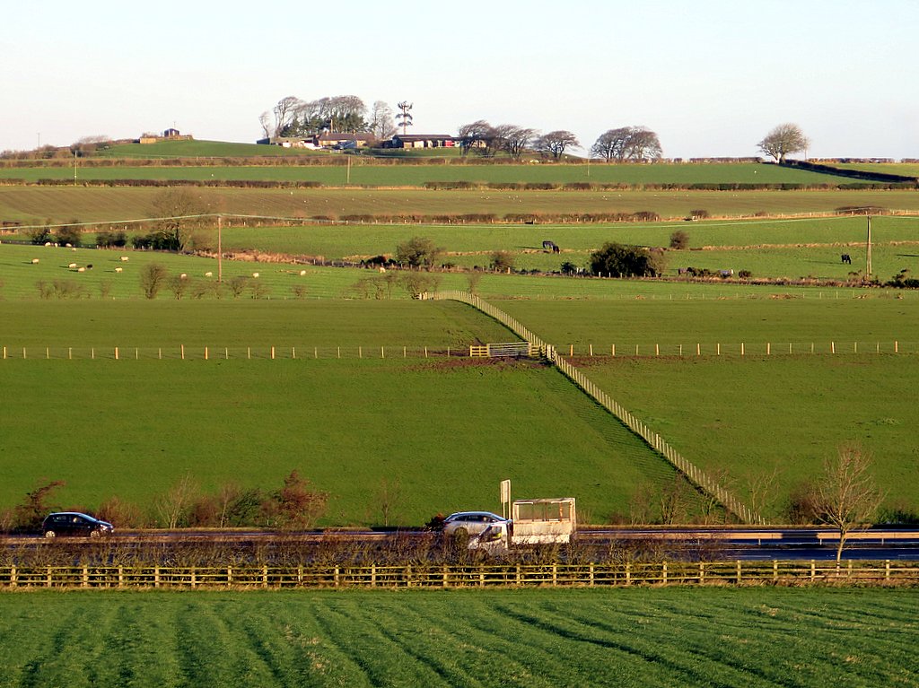
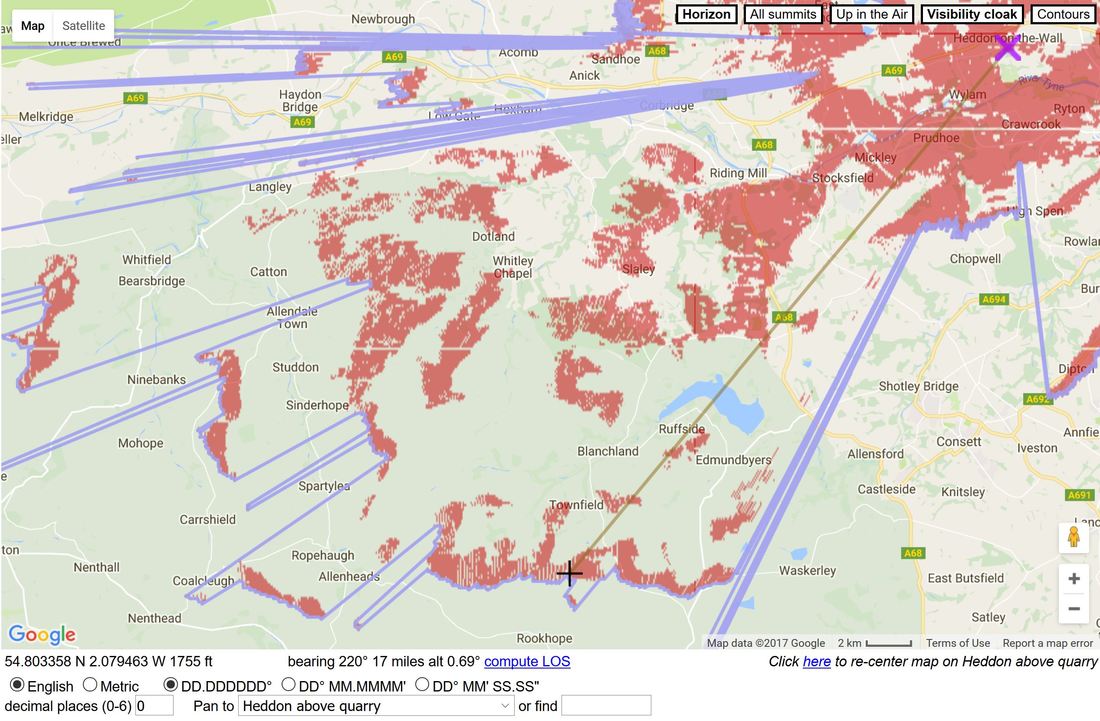
To the WSW, the northern tip of the Pennine chain at Cold Fell, above Brampton, is visible (33 miles, 258 deg.). Closer to home in the SW, are Kilhope Law (23 miles, 235 deg.) and the distinctive little peak of Bolt's Law, above Rookhope, (17 miles, 220 deg.). The latter is particularly visible, in suitable conditions, from the church porch. The Google map below shows its location with a black cross on the horizon line.
Further round to the NW, the program suggests that rare glimpses of the installation on Deadwater Fell above Kielder might be possible (36 miles, 301 deg.), although the narrow extent of view must make this almost impossible from ground level.
To the WSW, the northern tip of the Pennine chain at Cold Fell, above Brampton, is visible (33 miles, 258 deg.). Closer to home in the SW, are Kilhope Law (23 miles, 235 deg.) and the distinctive little peak of Bolt's Law, above Rookhope, (17 miles, 220 deg.). The latter is particularly visible, in suitable conditions, from the church porch. The Google map below shows its location with a black cross on the horizon line.
View from Heddon on the Wall to the SW. From heywhatsthat.com panorama.
There is probably nowhere in Heddon that you can go for a full 360 deg. view; there are too many trees and buildings in the way. Many of us have our favourite places that provide views in certain directions, and not just south over the Tyne valley. As well as the view above the quarry on Heddon Common chosen for my panorama, the top of Station Road, Heddon Banks, the Swan car-park, in front of the church porch, parts of the Hexham Road to Throckley, and the upper windows of Aunty Jean's house, are a few of mine.
One of the great views from Heddon is that to the SE, towards Newcastle, as shown in the first photo in this blog. The buildings and roads are picked out by sharp lights on cold winter nights when the blue lights of silent police cars can often be seen racing along the roads. Occassional events along the river have fireworks or lasers which play off the clouds.
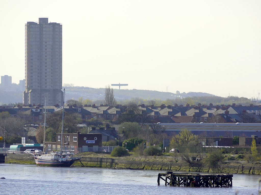
The panorama shows that the Angel of the North (10 miles, 123 deg.) is just hidden from view by the high ground at Wickham. You have to move one or two miles east of our village to see it. A panorama created from its location indicates that Walbottle might be suitable.
The photo at the top of this blog clearly shows one of the two blocks of flats off Waverley Road in Harlow Green (10 miles, 122 deg.), the other in line of sight behind, which is only 440m north of the sculpture and on slightly higher ground.
When Hadrian's Wall was planned it seems to have been as important to maintain good views to the south, even it appears at the expense of views to the north. It has been suggested that this was may have been for signalling back to forts located some distance south, those on the early Stanegate frontier line. Heddon on the Wall was the site of the twelth milecastle and the Roman fort just south of Washingwells Farm on the south-east side of Whickham is thought to have dated, as did Arbeia at South Shields, to this early period (late first century).
Forts were later built on the Wall line itself, including those at Benwell and Rudchester, and lateral signalling may have become more important. The locations of both of these forts would have been intervisible from our viewpoint and almost certainly from a tower on the 12th milecastle.
Dunston shore from Elswick showing the Angel of the North on the distant skyline. The 'Dunston Rocket' (left foreground) no longer exists. Photo A Curtis (2010).
Near at hand of course are Newburn Bridge (3 miles, 113 deg.), the Lemington Glassworks cone (4 miles, 111 deg.), and Blaydon Bridge, carrying its constant A1 traffic over the Tyne (5 miles 112 deg.), to the north of the river; the Metro Centre (6 miles, 116 deg.) and, further behind, Saltwell Towers (9 miles, 115 deg.) flanked by the high ground of Gateshead and Low Fell.
The furthest east that can be seen along the river is around Dunston Staithes where it turns to the NE into the heart of Newcastle.
The heywhatsthat panorama indicates that higher land near Houghton le Spring (17 miles, 125 deg.) and West Boldon (14 miles, 106 deg.) can be seen to the SE, and almost as far as Sunderland (17 miles, 108 deg.).
Newcastle itself remains hidden by the high ground of Benwell on the West Road (6 miles, 102 deg.), where the Romans built their fort (Condercum). Slightly north of this line there appears to be a window looking over the north parts of Newcastle and the Tyne (but all hidden) to the Cleadon Hills, site of South Shields Golf Club (16 miles, 96 deg.) and a stones throw from the sea near Souter Lighthouse.
Projected panorama from Heddon due E above the north part of Newcastle to the Cleadon Hills near coast between South Shields & Whitburn. The steep valley of the River Tyne is just to the right (south).
Is there a house in the village we could name, Sea View, Heddon on the Wall? Not mine, sadly. Tree View would be more appropriate. I would though be very interested to know what are people's favorite viewpoints from the village and what features you have seen or can see from them.
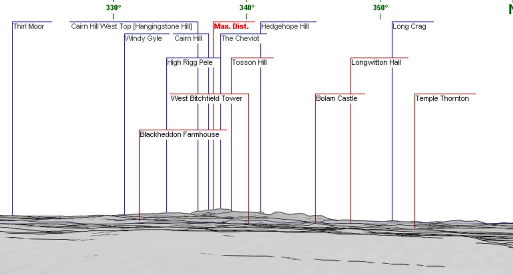
heywhatsthat.com is not the only panorama maker available. A German site, http://www.udeuschle.selfhost.pro/panoramas/makepanoramas_en.htm produces a nicely drawn and partly-labelled outline of the view from any location, also linked to Google Maps. The section of a 360 deg. panorama created from the same location in Heddon (below) shows the Cheviot and Simonside Hills on the northern horizon. The resolution and smaller exaggeration of the vertical scale (2.5) seems to have rendered the shape of these hills very realistically. On the Simonside range, only Tosson Hill has been labelled. Hedgehope Hill, some distance beyond) peeps over the gap between Tosson and Simonside to its right.
 RSS Feed
