
 |  Lambley Station (2005) © Copyright Les Hull and licensed for reuse under this Creative Commons Licence |
On October 10th, John Gillot, a member of our Society, gave us a talk about Railways in Northumberland. I walk a lot in many different areas of the countryside and often come across disused railway lines and wonder where they came from and where they went to. Railway history has always seemed so well documented that there can't be much left unknown, and it's a subject I've always left well alone.
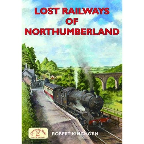
Inspired by John's talk, I looked for a suitable book and after a little research picked 'Lost Railways of Northumberland' by Robert Kinghorn published by Countryside Books in 2006. It seemed to cover all the lines that might interest me, is not too big, and has a nice painting on the cover of a steam train at Lambley Station with the viaduct behind.
Inspired by John's talk, I looked for a suitable book and after a little research picked 'Lost Railways of Northumberland' by Robert Kinghorn published by Countryside Books in 2006. It seemed to cover all the lines that might interest me, is not too big, and has a nice painting on the cover of a steam train at Lambley Station with the viaduct behind.
It's a statement in the first chapter that I want to discuss here which gave me a glimpse into a more confused world of railway history research than I had expected.
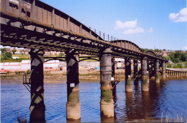 Scotswood Railway Bridge (2005) © Copyright Chris Bell and licensed for reuse under this Creative Commons Licence | 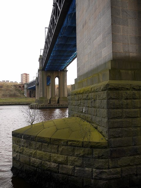 King Edward VII Bridge. Photo A Curtis (2011) |
The chapter deals with the Newcastle & Carlisle Railway (N&CR). The existing line from Newcastle Central Station now crosses the river by the King Edward VII Bridge and runs on the south side of the Tyne. The railway, however, first crossed the river by the first (wooden) Scotswood Railway Bridge, built in 1839, and approached Newcastle on the north bank. The disused bridge (the third) that still crosses at this point, was built in 1871, and was used until 1982, when passenger trains were re-routed via the King Edward Bridge.
Nothing contentious here so far but on page 16 Robert Kinghorn tells us:
'Ask where the station in Newcastle is today and everyone will direct you to Central Station. Ask about others and they will probably suggest various Metro stations. Imagine discovering a railway terminus within five minutes' walk of Central Station that is unknown to most people in present day bustling Newcastle.'
I thought I knew this area of Newcastle fairly well but this was new to me.
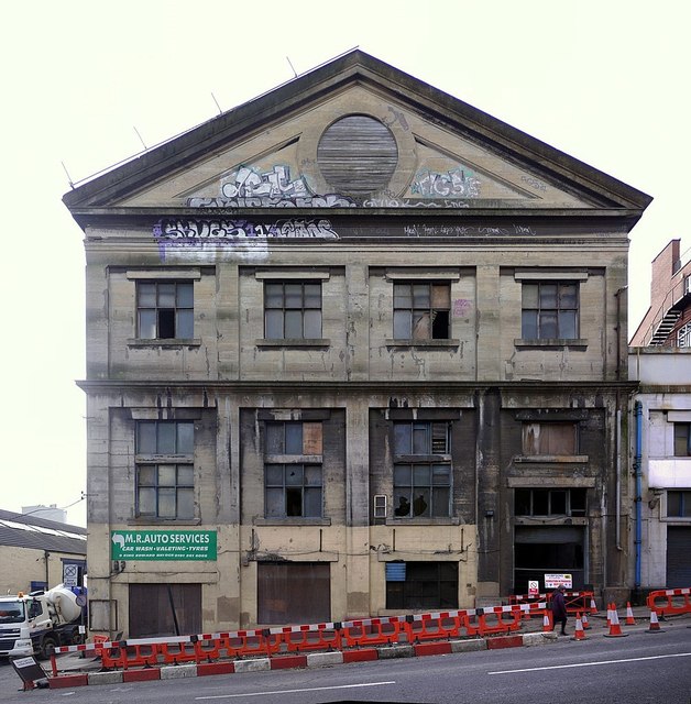
He then shows a photo of an old building on Forth Banks with the caption:
'Forth Banks Station today - it has not seen a passenger train since 1851' and refers to it as the [former] '... terminus of the line from Carlisle'.
'The platforms were on the second floor, with open arches into the train shed, which had a pitched glazed roof supported by iron trusses. The line ran alongside Pottery Lane over brick arches from Shot Tower station.'
'Ask where the station in Newcastle is today and everyone will direct you to Central Station. Ask about others and they will probably suggest various Metro stations. Imagine discovering a railway terminus within five minutes' walk of Central Station that is unknown to most people in present day bustling Newcastle.'
I thought I knew this area of Newcastle fairly well but this was new to me.
He then shows a photo of an old building on Forth Banks with the caption:
'Forth Banks Station today - it has not seen a passenger train since 1851' and refers to it as the [former] '... terminus of the line from Carlisle'.
'The platforms were on the second floor, with open arches into the train shed, which had a pitched glazed roof supported by iron trusses. The line ran alongside Pottery Lane over brick arches from Shot Tower station.'
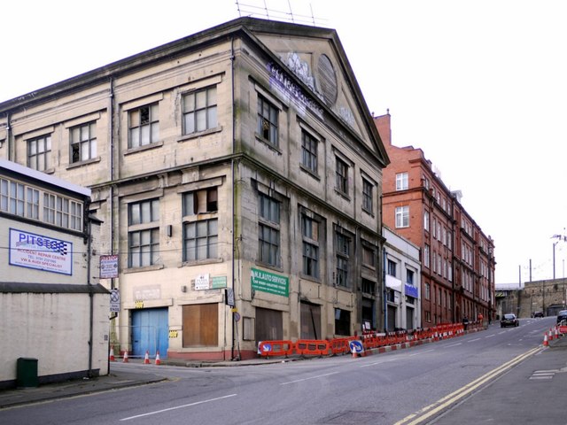
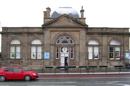
So what is this building and was it ever a passenger railway station? For several years now it has been covered by drapes and scaffolding but when I visited on 28th November these had just been removed providing a good view. One map names it as Forth Banks House. It is situated on Forth Banks on the corner of Pottery Lane, and is a Grade II Listed Building.
 |  |
© Copyright Andrew Curtis and licensed for reuse under this Creative Commons Licence
Tyne & Wear SiteLines provides some evidence on the Forth Banks Goods Station which was situated at the rear of this building, the remains of which can be seen along Pottery Lane, and, as an almost aerial view, from Redheugh road bridge
HER(4321) describes the first Forth Banks Goods Station thus:
'The single most important piece of railway architecture of the 1860s in the area was the North Eastern Railway's Forth Banks Goods Station, designed by Thomas Prosser in 1866. The new goods station opened for freight in 1871, replacing a small goods shed of the former Newcastle and Carlisle Railway (one of the companies which amalgamated in 1854 to form the North Eastern Railway). All that now survives of the goods shed [Prosser's Goods Station] is the undercroft, the south face of which is a sandstone wall pierced by arch headed openings.
In 1904 a new goods station office [Kings House] was built at the end of the site, facing onto Forth Banks. This building, an imposing structure faced with brick and terracotta, may have been designed by William Bell (architect for the North Eastern Railway from 1877 to 1923).
The following year Prosser's goods shed was cut in two by the building of the approach viaduct to the King Edward Bridge.
Shortly afterwards it was extended to the east by the addition of a smaller, three storeyed shed built alongside the new goods station offices. This shed, which is a ferro-concrete building in a plain but functional neo-classical style, was built by L.G. Mouchel's Hennebique Company to a design by Bell.'
Prosser's Goods Station was huge - and has been described as one of the largest in the world at the time, as can be seen in the photos below.
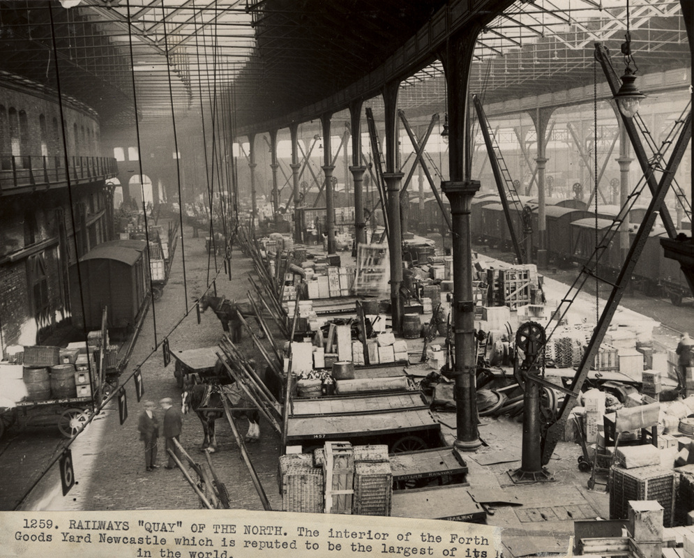 Interior photo of Forth Banks Goods Station (undated) | 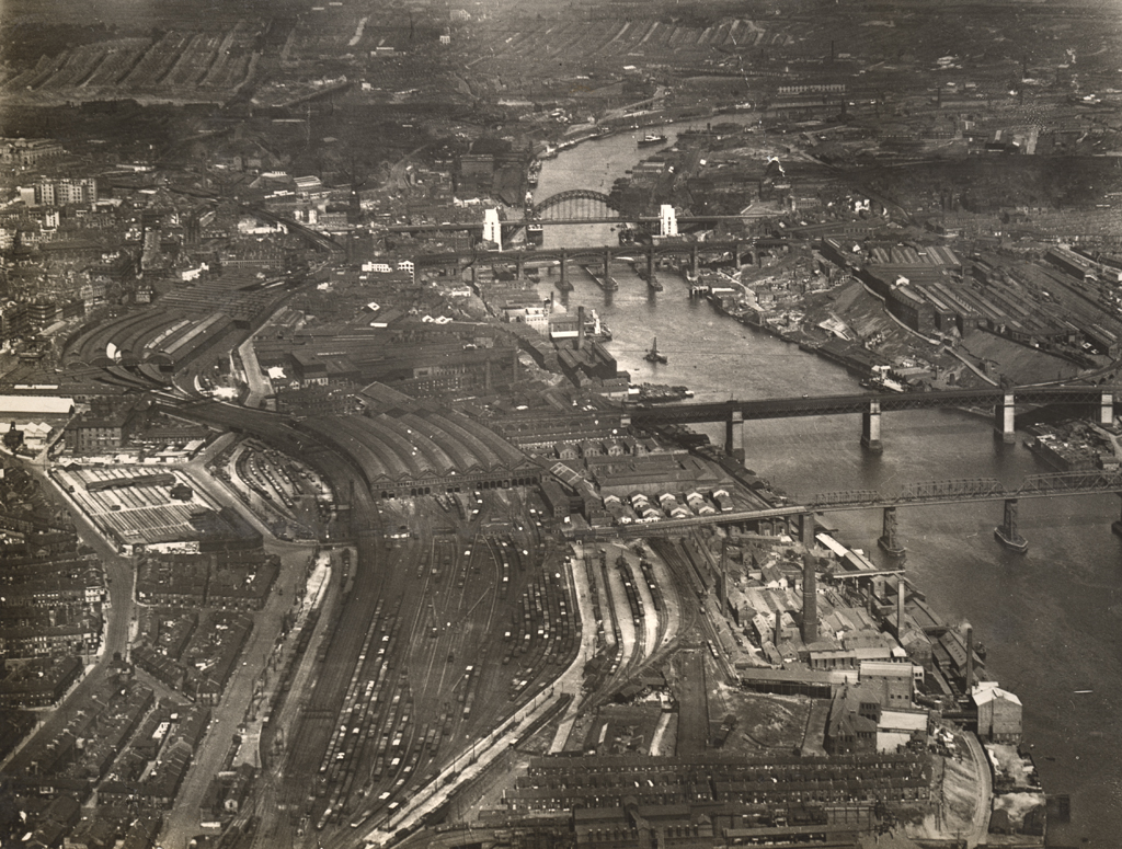 Aerial photo of Newcastle Bridges (c1929) |
Photos from Newcastle Libraries' Collection (linked from the photos)
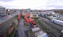 Forth Banks Goods Yard from Redheugh Bridge (2011) | 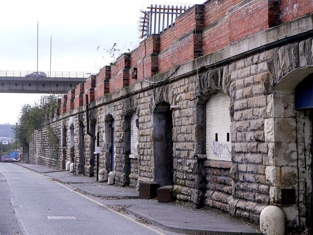 Pottery Lane towards Redheugh Bridge (2011) |
© Copyright Andrew Curtis and licensed for reuse under this Creative Commons Licence
The shed, which is the building currently fronting onto Forth Banks, is described in HER8917:
'Goods station warehouse, now general workshops. c1910. Designed by William Bell, for the North Eastern Railway Co., engineer LG Mouchel of Hennebique, using patent ferro-concrete, steel-framed roof with glazed strips and boarded rear gable. Simplified Classical style.'
There follows a detailed description of the architecture of the three-storey building including this:
'Pediment has wide surround which merges with similar surround to central slatted oeil-de-boeuf. referring to the upper bull's eye opening.
This then is the same building, and it is dated to the early 1900s, built in an early form of reinforced concrete.
By the time it was built, the terminus of the line from Carlisle had been ensconced in Central Station for over 50 years (from shortly after it was completed in 1851). There is a mention though of the early N&CR goods shed which was replaced by Prosser's huge building to the rear. Could this ever have been a temporary passenger terminus?
I was initially sceptical that this was ever the case, and considered that the mostly likely scenario was that described by Alan Young on the website Disused Stations.
He describes a first temporary terminus on Railway Street, just north of the current coach and car park, west of the Metro Radio Arena. This station was also called 'Shot Tower' after the famous landmark at the nearby Elswick Lead Works. It was used from 1839 to 1847. The rail junction leading to the Forth Banks Goods Station was just west of this location and crossed over Redheugh Bridge Road on bridges south of the main line. Most of these lines have now gone.
The second temporary terminus was given the name 'Newcastle Forth', or often just 'Forth'. Alan Young shows it on a site immediately to the west of Central Station off Neville Street and used from 1847 to 1851. This area, and the line to it, are now given over to railway car parking.
 Former site of Newcastle Forth Railway Station (2011) | 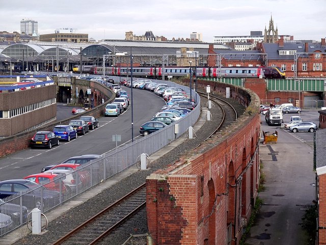 Newcastle to Carlisle Railway line (disused) (2011) |
© Copyright Andrew Curtis and licensed for reuse under this Creative Commons Licence
But maybe there was indeed a third temporary station between the time that Railway Street ('Shot Tower') was in use, and the time when the railway reached the now disused platforms west of Central Station. A station on the site that would later become the Forth Goods Station would account for some of the confusion, especially the station names in use that seem to include 'Forth', 'Forth Banks' and 'Infirmary' as well as 'Shot Tower' and 'Railway Street'.
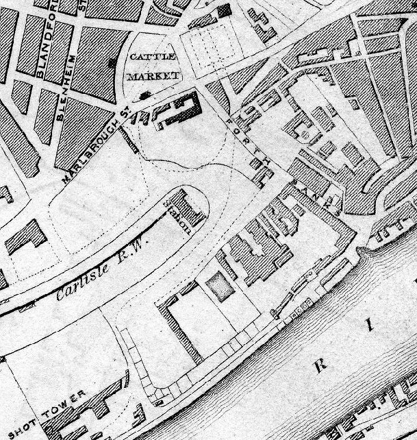 Plan of Newcastle upon Tyne and Gateshead by William Collard (1841) | 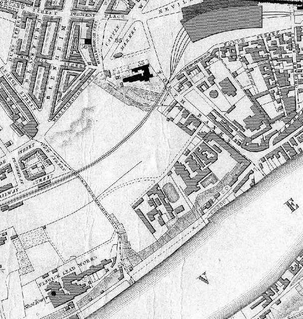 Plan of Newcastle upon Tyne and Gateshead by Thomas Oliver (1849) |
The 1841 map on the left shows a large terminus station due south of a large black-coloured building, west of the street still called 'Forth Banks'. The building just south of the Cattle Market was the former Newcastle Infirmary (demolished c1954). The 1849 map of roughly the same area and scale is given for comparison. By the time of this map, the railway had entered Central Station and the High Level Bridge was in operation.
John S. MacLean writing in The Newcastle & Carlisle Railway 1825-1862: The First Railway Across Britain. Compiled from Official Reports, Documents and Records. R. Robinson, Newcastle (1948) confused me some more.
Page 52 has:
'In October 1839, the Newcastle line was opened between Scotswood Road and Parker's Lead Factory where a passenger station was opened, but it was only a temporary one after all, as the directors found they were able to purchase more land east of the proposed site, thus bringing the main station about 300 yards nearer the centre of the town'.
On page 64, he tells us:
'The reason for building a temporary station was the fact that after land was purchased west of Lead Factory Lane, the company acquired more ground east of the Lane enabling a larger station to be built than was at first intended and bringing the main portion about 300 yards nearer the town, connected by wide roads with the Cattle Market and Forth Banks'.
'The first plans for the buildings and approaches to the 'permanent' station at Newcastle were prepared by John Blackmore and part of the earthwork and retaining walls on the south side had begun under his direction. In 1844, the only bit of the line unfinished was the short extension to the station...'
The 1841 map section above shows MacLean's wide roads connecting the temporary station ('Forth Banks Satation' or 'Infirmary Station') with the Cattle Market and Forth Banks.
Changes had been agreed, however, and land made available for a single Newcastle Central Railway Station on Neville Street.
'In March 1846, the line from the temporary station to the Forth Banks road, which is crossed by a handsome iron arch leading directly in to Central Station, was nearly ready and purchase of ground on the south side of Neville Street completed.'
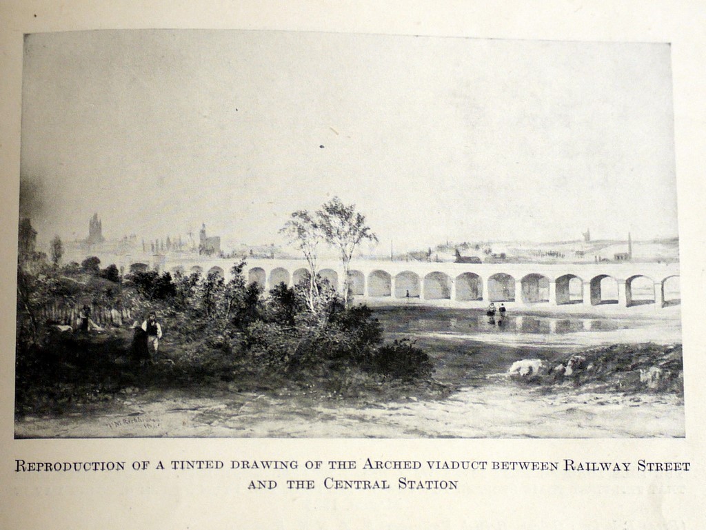 | 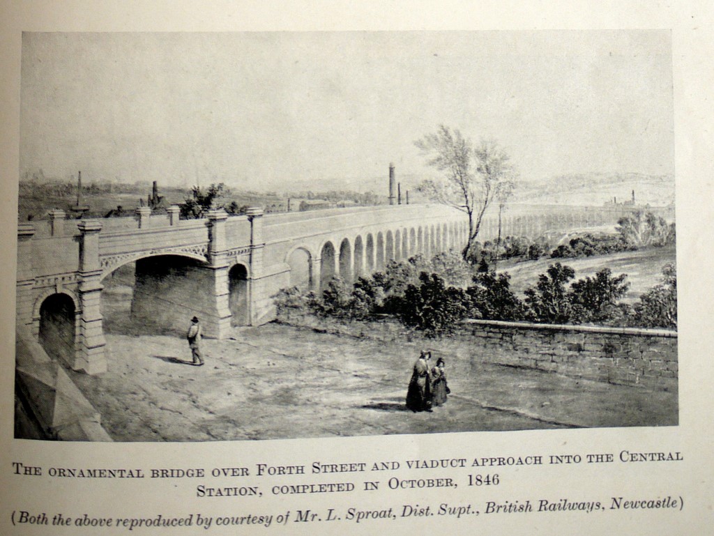 |
The statements on pages 52 and 65 may indicate another temporary state, but as the drawings above show, the line was now built on a viaduct to cross a bridge at the top of Forth Banks as it does today. The right hand drawing shows in the distance the Shot Tower of the Elswick Lead Works. Sadly the ornate bridge was swept away to cope with the new lines crossing King Edward Bridge, and the viaduct running across a pleasant landscape is now hidden by surrounding industry..
'In November 1846, the formal opening of the viaduct and line, extending from near Dunn Street, at a point slightly west of the 'temporary' station, to Forth Banks took place for passenger traffic.On March 1st 1847, the extension was finished and temporary wooden offices for booking passengers and parcels erected which were in regular use until the opening of the Carlisle end of the joint station on January 1st 1851. The east end of the Central Station was opened with great ceremony by Queen Victoria and Prince Albert on August 29th 1850.'
'In 1851, the company tackled the problem of providing a new goods warehouse and depot in Newcastle ... The directors finally chose the site where the Forth Goods Station now stands... The buildings were erected on green fields sloping down to the river.' The buildings were opened in 1854; the later Goods Station not built until 1870.
If the map evidence does indeed show a temporary passenger station at Forth Banks I've failed to find any old illustrations of it. The intention of the N&CR had always been to enter the shared Central Station, and the temporary buildings at Forth Banks may just have been wooden.
No 1 Neville Street. A Curtis (2011)
The first Forth Banks Goods Shed of 1852-53 was built in stone, however. The material of its construction, when it was demolished in 1871, was recycled into the carriage shed at the west end of Central Station. In 1883, this became the NER Goods Office and later Accountant's Office Link
Never believe everything you read, even this. Maybe I still have it wrong, and if so please let me know or leave a comment below. Other books dealing with the history of the N&CR seem to gloss over the story too, to some extent, and I'm sure it's not just me that's confused.
I hope the rest of the 'Lost Railways' book doesn't entail such a level of research though.
Planning permission has recently (2011) been granted for the incorporation of the buildings on Forth Banks (Bell's Goods Warehouse and Kings House to the north), along with part of the site of the Goods Station at the rear, into a £37 million new Central Police HQ for Northumbria Police. A 'station' of another sort.
Bill Fawcett (in A History of North Eastern Railway Architecture 2005, vol.3 p110) describes the Goods Warehouse thus:
'Despite its honest virtue, one cannot claim that the rain-streaked concrete facade makes appealing streetscape'. It will be interesting to see what the Police architects make of it.
There is lots of information here.
Railway Architecture of North East England - Forth Goods Station
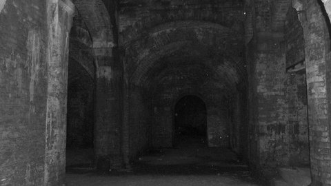
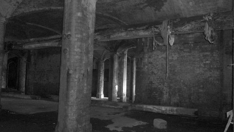
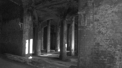
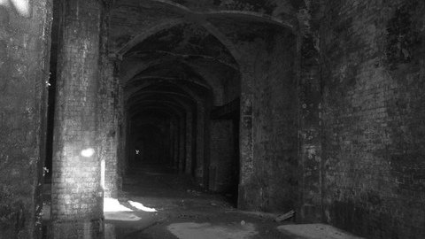
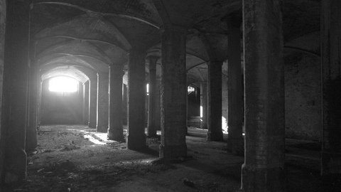
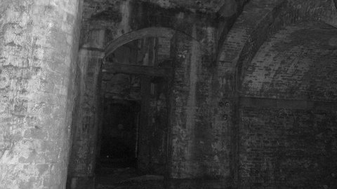
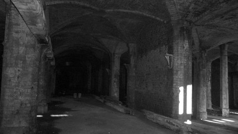
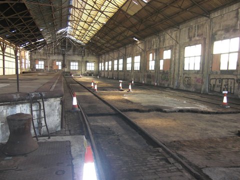
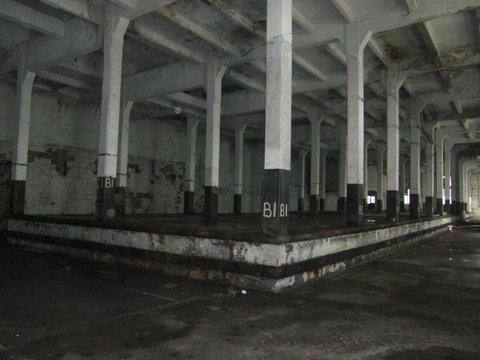
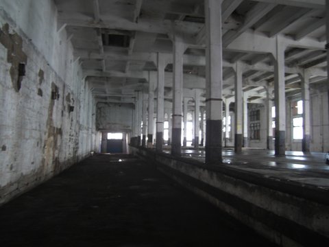
Below are photos kindly provided by Dennis Young of the Forth Banks Goods Station Undercroft which dates from the mid 1800's and interior of the early 1900's building at the junction of Forth Banks and Pottery Lane taken in 2010 before building conversion for Northumbria Police.


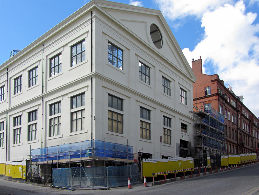
Forth Banks House & Kings House (undergoing renovation). Photo A Curtis (2013).
Hasn't the old building scrubbed up well?
 RSS Feed
