Heddon-on-the-Wall Local History Society
  • Home
  • Calendar
  • Introduction
  • Where are we?
  • History Map
  • Timeline
    • Prehistoric
    • AD43 to 1599
    • 1600 to 1799
    • 1800 to 1899
    • 1900 to 1999
    • 2000 to 2099
  • Heddon's History
    • Prehistory
    • Hadrian's Wall >
      • Vallum excavation (1893)
      • Hadrian's Wall excavation 1926
      • Wall ditch, Bays Leap (1958)
      • Hadrian’s Wall: Archaeological research by English Heritage 1976-2000
      • Throckley & Heddon entanglements
      • WallWatch
      • English Heritage (2020)
      • Wardell-Armstrong Archaeolgy Reports
      • Historic England Archives
    • Six townships >
      • 1 Heddon township >
        • Heddon in the Middle Ages
        • Common Land
        • Middle Marches
        • Tithe Award
        • St Andrew's Church >
          • Stained Glass Windows
          • Churchyard
          • Monuments of church & churchyard (1991)
          • Monuments Page 2
          • Vicars of Heddon
        • Village property
        • Heddon Hall >
          • Sale of Heddon Hall 2012
        • Heddon Banks Farm
        • Frenchman's Row
        • Methodist Church >
          • Heddon Methodist Church Centenary 1877-1977
        • Men's Institute
        • Women's Institute
        • Welfare Field
        • Knott Memorial Hall
        • Memorial Park
        • Schools
        • River Tyne
        • Coal Mining
        • Quarrying
        • Water Supplies
        • Transport
        • Waggonway & Railway
        • Occupations from 1800
        • Miscellaneous
      • 2 West Heddon township
      • 3 East Heddon township
      • 4 Houghton & Close House township >
        • Close House
      • 5 Eachwick township
      • 6 Whitchester township
    • Rudchester
  • People
    • Sir James Knott
    • Cadwallader J. Bates
    • Richard Burdon
    • Hugh Sinclair (Tim) Swann
    • George Clark
  • Old Photos
    • Postcards
    • Old photos 1
    • Old photos 2
    • Old photos 3
    • Old photos 4
    • Old photos 5
    • Old photos 6
    • Old Photos 7
  • Old News
    • Community News
    • Letter from the Emigrant Clergy of Frenchman's Row (1802)
    • Alleged Brutal Murder at Heddon-on-the-Wall (1876)
    • Sad boat accident at Ryton (1877)
    • Coronation tree (1902)
    • 65 Years on a Ferry Boat (1929)
    • Come claim your kiss at Heddon (1953)
    • The Swan (1972)
    • Heddon WI (1987)
    • Church House (1966)
    • Happy return (1993)
    • Hexham Courant (1997)
    • Butterfly Garden (1999)
    • Foot & Mouth (2001)
    • Remembrance Day (1996)
    • Remembrance Day (2016)
    • RAF at Ouston (2007)
    • Close House Golf Course (2009)
    • Heddon pupils celebrate British heritage (2011)
    • Roman Wall Forge (2011)
    • Diamond Jubilee (2012)
    • Auction of Bronze Statue, Close House (2012)
    • Heddon WI (2012)
    • Puffing Billy Festival (2013)
    • Heddon Village Show (2014)
    • View of the North (2014)
    • The Wall at Heddon (2014)
    • Heddon Village Show (2015)
    • War veterans singing send-off (September 2015)
    • Anglo-Saxon history (2014)
    • Heddon WI at 100 (2017)
    • Hadrian's Wall discovery (2019)
    • Tulip Mews (2020)
    • Mike Furlonger
    • Hadrian's Wall 1900 Festival
  • Memories
    • Olive White
    • Betty Cockburn
    • Betty Cockburn - miscellaneous information
    • Isabel Snowdon
    • William & Winnie Watson
    • Edith Ward
    • Mark Parker
    • Jack Lawson
    • Winnie Spoor
    • P Reay
    • Mr and Mrs Hall
    • Peter Chapman
    • Elizabeth Elenora Eames
    • Harry Murray
  • Other documents
    • Mackenzie (1825)
    • Bates (1886) >
      • Early & Roman
      • Townships
      • Heddon Church
      • Heddon & Houghton
      • Whitchester
      • Eachwick
      • West & East Heddon
      • Records
      • Addenda
      • Appendix A
    • History, Topography & Directory of Northumberland (Bulmer's) - 1886
    • History of Northumberland (1930)
    • Collingwood Bruce (1853)
    • Whellan (1855)
    • Post Office Directory (1879)
    • Prominent people in Heddon
    • Place names
    • Ad Murum
    • Archived documents
    • Thomas Bewick's History of British Birds (1826)
    • Census data 1801-1991
    • Historical Records 1888-1890
    • Knott Sale of Village Property (1924)
    • Extracts from Parish Council Records
    • Local colliery records
    • Blackburn (1938)
    • Clark (c.1963)
    • History of Church (1968)
    • Boundary Commission Report 1984
    • Village Atlas 2022
  • Walks
    • Walks 2
  • Blog
  • Contact us
  • Links
  • What's new
  • Site search
  • Past & Present
  • Photo of the Month
  • Place Name Studies
    • Meas & Meres
    • OS Name Books: Elsdon
    • OS Name Books: Allendale
    • OS Name Books: Cheviot Hills
    • OS Name Books: Other Parishes
  • Heddon 3D landscape

Jenny Pit (Heddon on the Wall)

4/7/2024

1 Comment

 
A recent interest of mine has been in using LIDAR for archaeology research and as part of this I've been looking again at my local area.
Picture
Jenny Pit, Heddon on the Wall. LIDAR (DTM 1m) © Environment Agency 2022.
One of the features that has caught my eye is a LIDAR Digital Terrain Model (DTM) of the disused Jenny Pit which is located at NZ143662, just SE of Heddon Hall. Heddon Hall was named Mount Pleasant on the 1st edition 6" OS map. The old coal pit lies on Heddon land but just west of the boundary with Throckley.

I have always considered it likely that some of the early waggonways to the many coal pits on the east side of Heddon parish may have crossed the Throckley boundary to connect up with the changing routes of Throckley waggonways leading eventually to the staiths at Lemington.

Like many of the old pits and spoil heaps in our area, Jenny Pit was reclaimed by planting its area with trees, as was also done on Throckley land. The extent of the plantation now hiding Jenny Pit is, however, larger than many of the others nearby. For example, it is several times larger than the near circular plantation which surrounds Engine Bank Pit just to the south.

Luckily LIDAR DTM can see through trees. The data within the LIDAR image has been processed (exagerated) to reveal more detail.
Picture
Area around Jenny Pit, Heddon Hall & Heddon Colliery. Lidar dtm 1m enhanced.
What is revealed below the trees is a impression shaped like a tennis racket, with the handle pointing to the SE where it ends at the fence which forms the Throckley boundary. The field to the east has been cultivated for many years and appears completely smooth on LIDAR unlike the narrow rig & furrow ploughing which remains around the disused pit in the pasture land below Heddon Hall.

This looks very much like the pit-head terminus of a former waggonway extending onto Heddon land.

Directly below the site of the pit, running straight west to east (not entirely level as slightly downhill to the west) is what I had considered to be an old field boundary. Indeed it is shown as such on the 1st edition map, with trees shown along its length. The LIDAR image suggests that it is double banked, some 7m in width, although possibly with a ditch on its N (uphill side). Could this also be the remains of a waggonway. Its direction takes it just to the north of King Pit, on the 1st edition map. This eventually became the location of Heddon Margaret Colliery. There is also a Richard Pit to the north.

A waggonway connection to these Heddon pits with the Throckley waggonway system would have predated the collieries eventual connection to the south, with the railway successor of the Wylam Waggonway.
Picture
Location of Jenny Pit. Side by side georeferenced maps, National Library of Scotland: Six-inch 1st edition and ESRI World Imagery.

Heddon & Throckley - 3D lidar landscape by NOWTAG on Sketchfab

Beyond the racket-handle of Jenny Pit, on Throckley land, there are the small tree-covered remains of another coal pit, shown as Coronation Pit on a plan of Throckley estate. This could also have been served by the suggested waggonway as could several other old pits to the north of Reigh Burn, e.g. West Engine & East Engine Pits. There is a similar sized depression shown on the LIDAR image, close to Jenny Pit on the Heddon side of the boundary, which could be the remains of a ventilation shaft.
I contacted Les Turnbull about the LIDAR observation at Jenny Pit and he suggested the similarity to the waggonway termini depicted at The Far Pit (E) and The Middle Pit (D & C) of Heaton Main Colliery, shown on Watson's plan of 1805.
Picture
Figure of Watson's Waggonway Plan of Heaton Main Colliery from Les Turnbull, Coals from Newcastle, 2002.
It has to be said that there is speculation of other waggonways or tramways across these fields around Heddon Hall. For example, Historic England's Aerial Archaeology Mapping Explorer shows several possible features, but these appear to me less convincing. For example, one is the straight bank running W-E just above Jenny Pit, and another is one of the two converging features to the west.
Picture
Part of Historic England's Aerial Archaeology Mapping Explorer suggesting possible waggonways in the area surrounding Heddon Hall (2024). Jenny Pit is just right of centre (represented as an area of coal working).
The Aerial Mapping Explorer also shows a crop or soil mark, interpreted as the route of a waggonway, running diagonally through Throckley from the jucntion of the Hexham Road and Coach Road, through what is now a housing estate, towards the Leazes on the west side of Hallow Hill. It is recorded as Monument Number 1437960. Lidar shows its likely course running across the south face of the hill. It appears to join the line of the former mineral railway which runs just north of the Reigh Burn which served Throckley Isabella Colliery and  probably on the line of the former waggonway discussed here from Jenny Pit.

Although a different interpretation of this line clearly doesn't preclude it from being the former course of a waggonway. it seems to me that the line observed here is close to that used by the pipelines of 24" and 30" (1869), for trade and domestic water supplies respectively, from a well originally constructed at the terminus of the Throckley Aqueduct (1866). Filter beds were built on the site of this well in 1875, and a valve house even later (a listed building c1890) located south of the Hexham Road, below the filter beds, and immediately west of the Coach Road junction, very close to where this supposed waggonway starts. Information taken from R W Rennison (1979) Water to Tyneside. See Map 9, p.112
.
Picture
Valve House, corner of Hexham Road & Coach Road, Throckley. Photo A Curtis (2013).
If the LIDAR image of Jenny Pit does suggest a waggonway terminus, presumably branching sidings where waggons could be stored, waiting to be filled or transported, then what could the circular feature at the northern end be. It is about 15m in diameter, too wide for a mine shaft. One possibility could be the platform of a horse-drawn gin. Perhaps something similar to the winding machinery for a close-by shaft sketched by Sir John Clerk and reproduced in Les Turnbull's book on page 48. Maybe Jenny Pit was operated in the pre-steam era or too far out to be considered for conversion.
Picture
The east side of the whim gin sited at the east end of the Pockerley Waggonway. Beamish Museum. From Wikipedia Commons.
Picture
If the feature does represent a waggonway serving Jenny Pit on Heddon land then its trajectory onto Throckley land would appear to take it along the gently curving boundary to the east (now a footpath into land which is now part of Tyne Riverside Park). The area further east has been greatly altered by the subsequent location of Throckley Isabella Colliery and eventual restoration of the land. The waggonway would have run north of the Reigh Burn, joining the Wylam Waggonway somewhere just below Newburn Grange Farm. Part of this route could have been later used by the mineral line which served Isabella Colliery.
Picture
Footpath on a track north of Throckley Pond looking very like a waggonway. Photo A Curtis (2024).
I have plotted the conjectured line (the lower purple line) on my revised plan of the Throckley Coal Pits & Waggonways.

If the line running across the field just south of Jenny Pit, also represents the line of a waggonway, perhaps later modified as a field boundary along which trees were planted, this could have served a pit (spoil heap and shaft) located close to the east of Station Road. This is just north of Flocktons and the location of Heddon Colliery. Another shaft is in the wood on the same side of the road just to the north, and, as it has sunk slightly in the centre, reveals a few courses of fine stone-built masonry. Perhaps this was a ventilation shaft.
Picture
Disused coal mine shaft below Heddon Hall. Photo A Curtis (2015).
Picture
1 Comment

Coal mining in Throckley

29/5/2024

0 Comments

 
A preliminary attempt at drafting a summary of the history of coal mining in Throckley. The problem as always, what to leave out?

Throckley – coal mining
 
Primary source for this summary is:
Morrison, Jennifer (2007) Newburn Manor: an analysis of a changing medieval, post-medieval and early modern landscape in Newcastle Upon Tyne. Masters Thesis, Durham University.

  • Documentary references to coal mining in the Throckley area date back to the C14th (medieval period). Seams close to the surface could be exploited by drifts dug into the valley sides or by digging of 'bell pits' or 'day holes' (shallow vertical shafts).
  • In  1536, coal workings passed to the King, who then leased them to individuals. The Newburn mines passed to the Lord of the Manor, the Earl of Northumberland, and the mines at Throckley passed from the Crown to the Radcliffe family in the early C15th.
  • Radcliffe estates (Earl of Derwentwater) confiscated by the Crown and passed to Greenwich Hospital in 1735.
  • The tiny village of Lemington had been established at the staiths some time before 1620 when a few coal pits were being worked. ‘Sea-coal’ was transported from the staiths to colliers via the River Tyne.
  • George Stephenson’s father left Wylam to become fireman at Dewley Colliery. George’ first job  (age of 8), was for Grace Ainslie, farmer at Dewley Farm, guarding the cows which grazed the wagonways. He went on to become assistant fireman at the colliery before moving to Newburn.
  • The boundary between Newburn and Throckley was not fixed until the C17th. Remaining woodland in the area was felled for use in wagonways, pit props, staiths, wagons, keels etc.
  • Wagonways brought coal from Wylam & Throckley to Lemington Staiths from 1748. In the early 1800s, wooden horse-drawn wagonways were being replaced by new technology: metal rails, stream locomotives replacing horses (e.g. Puffing Billy & Wylam Dilly on the Wylam Wagonway).
  • By 1781 the main coal pits in Throckley had gone out of use and several former wagonways became  paths.
  • William Brown, colliery viewer, was brought up in Throckley. He had been appointed manager of Throckley Colliery by the lessee, Mr Bell, in 1756. Having erected a steam engine at Throckley, Brown went on to build engines at over twenty-one other collieries. In 1765 a new winning at Throckley was completed, and because steam-driven pumps helped solve the problem of pit drainage, shafts could be sunk to a greater depth.
  • In 1785, there was a list of 52 pits at Throckley, connected by wagonways to Lemington staiths, all worked by Bell and Brown. This colliery was worked out by 1794.
  • Messrs. Bell and Brown built the row of houses on the Hexham Road in 1796 that were to become known as Frenchmen's Row.
  • By 1858, the OS map shows several coal pits, most at the edges or corners of fields surrounded by small copses of trees. Some are out of use. The most extensive colliery workings were located at Throckley Colliery (Meadow Pit), which was served by a wagonway. To the east of this lay Throckley Brick and Tile Works.
  • At Throckley C19th mining involved the continuation of working of some of the pits which had been sunk in the C18th (such as Meadow, Maria, Rye, Nymph and Thristle) but most of these were out of use by 1895.
  • The Throckley Coal Company was formed in 1862 and Throckley Colliery opened in 1867. Maria Pit, which had been in existence in 1767 was expanded during the 1800s and was in operation until 1954. Isabella Colliery was in operation from 1869 to 1954.
  • In 1867, Throckley Coal Co. brought the extensive Isabella Coke Ovens complex into production, mainly for use at Spencer's steelworks. Twenty-two coke ovens was built using Stephenson's bricks, close to the Isabella Pit. Other coal-dependant industries of the period included brick and tile making.
  • Throughout the nineteenth century industrialisation continued. In 1875, the route of the Wylam Wagonway became a branch of the North Eastern Railway. The old Throckley Wagonway was re-used for a mineral railway which served the colliery and brick-works.
  • Margaret Pit, in Heddon, was sold  to the Throckley Coal Co. in 1902. This allowed them improved control over water ingress in the Throckley pits. In 1906, Throckley merged with the brickmakers, Wm Stephenson & Sons and sank a third mine, the Maria. They continued to work Heddon Colliery until the early 1930's, when it was closed, and the remaining coal reserves accessed from Throckley Isabella.
  • The Stephensons and Throckley Coal Company provided their employees with many facilities including chapels, school, houses & institute.
  • Coal production ceased at Throckley Colliery in January 1954 and land was reclaimed. Opencast mining in 1991 destroyed the remains of the water mill, a section of the C18th wagonway, and several old pits. A69 (by-pass) built.
0 Comments

Some maps of Throckley

23/5/2024

0 Comments

 
Picture
Picture

Heddon & Throckley - 3D lidar landscape by NOWTAG on Sketchfab

0 Comments

Tyne Riverside Park, Newburn

6/5/2024

0 Comments

 
Picture
Engine Plantation, Throckley. Formerly the site of Throckley Isabella Colliery. Photo A Curtis (2021).
Information on the reclamation of former industrial land between Throckley & Newburn in the creation of Tyne Riverside Country Park.
Hesselberth A & Hobson D (2003). Land reclamation in the North East: the last 30 years.
Chapter 4 (p. 81-89) in: H.M. Moore, H.R. Fox, S. Elliott, Land Reclamation - Extending Boundaries: Proceedings of the 7th International Conference, Runcorn, UK, 13-16 May 2003.


ABSTRACT: The North East of England has a long and glorious industrial heritage. This has led to a legacy of derelict land, but also to opportunities for reuse and regeneration. Government priorities and means of funding have changed over the last 30 years. The paper examines how land reclamation has progressed from the 1960s to the present time. It also looks at what has happened to land reclaimed during the earlier times and draws conclusions about the lessons that can be learned.

Picture
Slipway, Tyne Riverside Country Park. Photo A Curtis (2016).
4 Case Studies

4.1
Isabella colliery
An area of approximately 50 ha of land on the North bank of the River Tyne between Newburn and Throckley lay derelict for many years following the cessation of mining and the closure of a railway line. The site contained a number of interesting features including a scrap yard, railway track bed, waste heaps, lagoons, shafts from which mine water continuously discharged, and an area used by the water company for the disposal of liquid sludge from its settlement beds at a nearby treatment works, Natural drainage of the area had been disrupted by mining subsidence and flooding of the surrounding fields occurred during winter periods. The mine water was badly discoloured with yellow ochre and this was discharged via approximately 1.5km of open water course into the River Tyne. The site was not considered to be contaminated and therefore was not subject to chemical testing.

The site was reclaimed to create what is now known as the Tyne Riverside Park at Newburn. It was financed through l00% Derelict Land Grant. additional funding from the County Council and a small contribution from the Sports Council.

For a period of about three years prior to reclamation, surplus soils were brought onto the site from various sources. These were mainly from private developments being undertaken in the region and soils primarily comprised subsoils and clays. In most cases a small charge was made for accepting the materials and this provided additional funds for the project. These operations were not considered as waste disposal and therefore were not licensed under the Control of Pollution Act 1974.

The scheme involved the creation of a new land-form by regrading and covering over with the imported soils to form a growing medium. The scrapyard was cleared and visually dirty materials were removed off site for disposal in landfill. Mine shafts were capped but not filled and the drainage of the area improved as tar as possible by cleaning out channels and the installation of a flap valve upstream of the mine water discharge in order to prevent back flow into the areas worst affected by flooding.

The most challenging part of the scheme was the treatment of the area used for disposal of water company sludge. This had collected in a depression to a depth of about 3m and was of a consistency similar to jelly paint. Dewatering of this material was achieved by spreading it in thin layers and allowing it to freeze during the winter. The material was also found to. be useful as a soil enhancer although. because of the high moisture content it was extremely difficult to handle. Provision for future disposals of sludge was provided in cooperation with the Newcastle and Gateshead Water Company. The water company agreed to spray future discharges of sludge in order to spread it in a very thin layer that would be capable of drying over the winter. A large grassed area was therefore created under which a layer of gravel and system of pipes were installed. This would not have been feasible without a ready source of a large quantity of gravel. This was obtained by the excavation of a large slope into the bank of the River Tyne which comprised excellent quality river gravel. This operation was considered eligible for Derelict Land Grant because it was essential to the restoration of the site. The excavated area conveniently produced a slipway which was concreted over and this is still the largest access into the river for recreational purposes today.

The whole site was landscaped creating areas of grass and woodland with about 30% being returned to grazing land and the remainder being made available as a country park. The scheme was awarded first prize in the RICS/Times Conservation Awards RICS (1982). It is now a well used and mature country park.

Picture
Remains of Throckley Isabella Colliery Coke Oven. Photo A Curtis (2016).
Picture
Locally made bricks, Isabella Coke Ovens. Photo A Curtis (2016).
Picture
Polluted land from water filter beds at Tyne Riverside Park. Photo A Curtis (2013).
Picture
Great burnet (Sanguisorba officinalis), Tyne Riverside Country Park. Photo A Curtis (2015).
Picture
Flower-rich grassland, Tyne Riverside Country Park. Photo A Curtis (2015).
0 Comments

Journal of William English

25/6/2021

0 Comments

 
I have just received the following notification about the launch online of the Journal of William English.

"I am writing to announce that the website and journal of William English, (www.williamenglish.net) a miner originally from the North East of England who through hard work became a mining engineer in the gold mines of South Africa, is now live.
The website and journal covering the period 1875 to 1915 has been a project for William’s descendants, Hilary Norris and Larry Cunningham.
William found his own first job as a trapper when he left school at thirteen but after a week, ‘I didn’t like the mine, and wanted to leave, but my father said I had looked for the job myself and would now stay there. Well that fixed my destiny, but I know I should never have been a miner’.
William later followed in his father Henry’s footsteps and found work in the mines of South Africa. In 1899 he joined the Kaffrarian Rifles, fighting in the Boer War, and keeping a diary of each skirmish he took part in.
It is possible the journal was begun around this time. William’s life wasn’t solely defined by his work as a mining engineer although he details the materials, costs and dangers involved. He had many other interests, cycling perhaps being his greatest passion.
In transcribing William’s journal we have tracked the tragically short life of a self taught man in his own words. Additional material adds context and background information on the family. If you’d like to contact us please do so on [email protected] Larry Cunningham & Hilary Norris June 2021"
The homepage of the website is here: https://williamenglish.net
William English was born in Wylam in 1875 and died in 1915 at the Phthisis  Sanatorium at Modderfontein, near Johannesburg in South Africa.

His Journal probably written at a much later period of his life has been transcribed by his relatives and the website contains much more information about places and historical context.
Picture
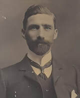
William English 1875-1915.
Picture
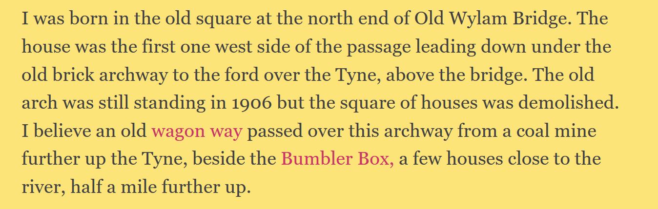
Excert from the transcription of page 1 of William English's Journal
Picture
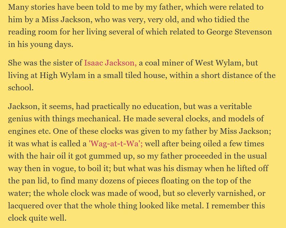
Excert from the transcription of page 2 of William English's Journal
Some information about Isaac Jackson, his clocks and model steam locomotives can be found in the blog articles on this site. There is also information about the song, Canny Wylam.
0 Comments

Heddon Colliery & Brick Works

2/6/2021

0 Comments

 
Picture
Heddon Colliery & Brick Works c1908
Picture
Flocktons & Station Road. Photo by John Flockton Sipple-Asher (1952).
Photos by A Curtis (May 2021)
Picture
Heddon Colliery & Brick Works. OS 1:2500 (c1900) & DTM LIDAR (2017) from NLS.
Link to 1:2500 georeferenced OS and LIDAR in Side by side view at National Library of Scotland.
In LIDAR data, the digital surface model (DSM) represents the earth's surface and includes all objects on it. In contrast to a DSM, the digital terrain model (DTM) represents the bare ground surface without any objects like plants and buildings. The laser pulses from the tree canopy are effectively removed from the data allowing the model to see through the trees.

Document about site history by Tyne Valley Gun Club

The land which measures approximately 10 acres is contained wholly within the North Tyneside Green Belt and was formerly the Margaret Pit and Heddon Brick Works. It was active as a colliery and brick making works until 1947 when operations ceased.
Until 1949 the site was used as a printing works then for light engineering and thereafterwards  for the storage of paper.
In 1962 the then Minister of Housing and Local Government confirmed a Discontinuance Order requiring the use of the land for general industrial purposes to be discontinued and required all buildings and works on the land to be removed.
Protracted negotiations took place regarding compensation payment, and in 1965 final settlement was agreed on the basis of a cleared site without industrial use but with the benefit of an alternative use as a single dwelling house.
Since 1949 a series of applications were made for planning permission for various uses and details of these applications and their determination are as follows:
  • 1949 Drying and processing in respect of concrete block manufacture REFUSED
  • 1953 Development of land for housing REFUSED
  • 1959 Development of land as a caravan site REFUSED
  • 1960 Use of old tile works for vehicle spraying REFUSED
  • 1965 Establishment of Country Club REFUSED
  • 1967 Conversion of former colliery winding house to dwelling REFUSED (& DISMISSED ON APPEAL)
  • 1968 Mobile washing plant REFUSED
  • 1974 An application was made by the Northumberland County Small-bore Rifle Association for the development of of an outdoor small-bore rifle range with future storage, changing and toilet facilities.
The application was REFUSED for the following reasons:
  • undesirable sporadic development contrary to the established policy of preserving the open, undeveloped character of the area.
  • associated noise and activity prejudices the amenities of nearby residents.
  • increased use of a winding road with no adequate provision for turning or parking of vehicles prejudicial to road safety.
An APPEAL was lodged against the planning refusal and subsequently determined by written representation. In a letter dated 30th January 1976 the Secretary of State, taking into account comments received from interested parties, advised  that he had allowed the appeal and granted planning permission subject to details of the design of buildings, site landscaping and means of access.

In September 1977, an application was received from the Tyne Valley Gun Club for the addition of two 25 metre pistol ranges. This application was considered by the Development Control Committee in October and approved subject to landscaping requirements, dates and times of shooting.

Owner of adjoining property submitted technical details in respect of provision of earth ramparts in an effort to baffle sound from the ranges. The Club were prepared to implement these reccommendations in full and this was done.

The application was further considered in January 1978 and deferred for a site visit to assess the problem of noise. On 2nd February approval was granted subject to revised shooting times.

On 27th April 1978, because of continual complaints from adjoining owners and in an effort to establish better public relations a further revision of the shooting times was approved in order to increase the 'quiet period' until the second Sunday in September.

An application by the Gun Club on 3rd July 1980  to extend shooting times into July was REFUSED.


0 Comments

Service for 'father of the coal trade'

8/4/2017

0 Comments

 
Church service on Sunday 2nd April 2017 in memory of William Brown, local mining engineer (1717-1782).
Picture
Hexham Courant, Friday 31st March 2017.
Picture
Norman font still in use today. William Brown was baptised here 300 years ago. Photo A Curtis (2015).

Read More
0 Comments

Big machines at Bay's Leap

15/12/2016

0 Comments

 
Photos and captions of the Bay's Leap open cast mining kindly provided by Alan Douglas of Throckley.
Yes, all was peace until one day,
A host of man arrived.
To dig black diamonds from the ground,
They wouldn't be deprived.

Machinery rolled in day by day,
Descending on the farm.
Tractors, scrapers, diggers too,
At first they caused alarm.

The months rolled by and now we see,
The surplus in a heap.
Towering high above the fields,
The death of old Bays Leap.
Above are the last three verses of The Death of Old Bay's Leap by Alan Duggan written in 1958. The rest of his poem, a nostalgic memory of the lost beauty, tranquility and productivity of Bay's Leap Farm at the onset of open cast coal mining, has already appeared on this blog.

Today we look at the other side of the coin. The photographic memories of one of those men who operated the machinery, dug out the coal and, at the end, restored the land back to farming.

Read More
0 Comments

Recovering memories

8/12/2016

0 Comments

 
The following poem was kindly sent to me by Mike Jones working with Averil Dawson, a resident of the care home, Grovewood House, which specialises in dementia care.
I work in conjunction with the two local Universities and several care homes seeking ways to assist those living with dementia. Part of my work entails using drama and the written word to address thoughts and feelings as expressed by those with whom I work.

Over the past month I've completed a poem which records the emotions of Avril on the day her weeping father dressed her ahead of the official closing of North Wallbottle Colliery. It was of course the day he lost his job. It had never crossed my mind that such an event could continue to impact so heavily across the generations but Avril opened my eyes to the reality with her thoughtful words.

She made me recognise that for some, as the poem concludes, "there will be no closure".


Read More
0 Comments

Heddon Colliery Powder Fund

31/7/2016

0 Comments

 
The following post by Swakopmunder appeared on the Mining Checks, Tallies, Tokens & Medals forum of the National Mining Memorabilia Association in 2009.
Picture
Heddon Colliery Powder Fund Check/Badge

Has anyone ever come across any UK mining explosives issuing tokens or similar? I know such tokens and checks were used in the US coal industry and had been told by at least a couple of very old English colliers that they remembered using something similar in their pits (pre 1947).

Recently I picked-up a 32 mm dia. brass embossed check which had around the edge of its obverse the legend HEDDON COLLIERY POWDER FUND plus two small pierced holes at 3 and 9 o’clock (like those on miners’ association checks/badges). The check did not have a stamped number in its centre like on a lamp or time check etc. instead this space was empty. The revere of the check had the embossed name and address of its maker in a circle. This maker was once a prolific producer of brass pub and other tokens in County Durham and Northumberland and also possibly operated a brass foundry.

Heddon Colliery closed c.1930 and was located 7 miles West of Newcastle-on-Tyne near to the pit village of Wylam (George Stephenson’s birth place). As far as I know this is the only check of any sort known from this colliery as none are recorded in Jeff Gardiner’s book of Durham and Northumberland Tokens.

Presumably the reference to POWDER on this check is to black or gunpowder used for blasting. The word FUND implies to me that there was some sort of communal fund that the miner’s paid into to purchase their powder. Bulk buying of powered or any other sort of mining consumables, by a group of miners, probably brought with it cash discounts which would be the incentive to joining such a fund/club. Possibly the check with its two distinctive piercings was issued by the system’s organisers as a type of membership badge to paid-up fund members, much as miner’s association checks/badges were used. The wearing of the badge would also act as a good advertisement for the scheme that presumably paid more financial discounts to the members the more miners were part of it.

The makers details are embosed in small letters in a circle in the middle of the check's reverse and read: Vandervelde & Co Makers, Newcastle on Tyne. No one knows if this famous north east token manufacturer produced colliery checks for the Great North Coalfield but I suspect that he did. Many of his other pub tokens etc. are also signed. I also have an outdoor type ornate brass head office wall plaque for the Pontop Coal Company that is also signed by him as the maker. I think it's likely he was well connected with the north-east colliery owners and probably did make a lot of the areas lamp checks.


0 Comments
<<Previous

    RSS Feed

    Author

    Andy Curtis

    Archives

    July 2024
    June 2024
    May 2024
    April 2024
    March 2024
    January 2024
    November 2023
    February 2023
    November 2022
    September 2022
    August 2022
    June 2022
    May 2022
    January 2022
    December 2021
    November 2021
    September 2021
    August 2021
    June 2021
    May 2021
    October 2020
    June 2020
    May 2020
    March 2020
    November 2019
    August 2019
    July 2019
    March 2019
    January 2019
    November 2018
    October 2018
    August 2018
    July 2018
    June 2018
    April 2018
    March 2018
    January 2018
    October 2017
    September 2017
    July 2017
    June 2017
    May 2017
    April 2017
    March 2017
    February 2017
    January 2017
    December 2016
    November 2016
    September 2016
    August 2016
    July 2016
    June 2016
    May 2016
    April 2016
    February 2016
    January 2016
    December 2015
    October 2015
    September 2015
    August 2015
    July 2015
    June 2015
    May 2015
    April 2015
    March 2015
    February 2015
    January 2015
    December 2014
    November 2014
    September 2014
    August 2014
    July 2014
    June 2014
    May 2014
    April 2014
    March 2014
    February 2014
    January 2014
    December 2013
    October 2013
    September 2013
    August 2013
    July 2013
    June 2013
    May 2013
    April 2013
    March 2013
    February 2013
    January 2013
    December 2012
    November 2012
    October 2012
    September 2012
    August 2012
    July 2012
    June 2012
    May 2012
    April 2012
    March 2012
    December 2011
    November 2011
    October 2011
    September 2011
    August 2011
    June 2011
    May 2011
    April 2011
    March 2011
    February 2011


    Categories

    All
    Agricultural Engineering
    Archaeology
    Barrow
    Bays Leap
    Beamish Museum
    Beer
    Beer-mat
    Bewcastle
    Books
    Border Line
    Brewery
    Brown
    Cabinetmaker
    Charlton
    Cheviots
    Churches
    Civil War
    Clennell Street
    Close House
    Coal Mining
    Cullercoats
    Cumbria
    Eachwick
    Earl Grey
    Elswick
    Family History
    Fishing
    Fishwives
    Folkestone Warren
    Forth Banks
    Furniture
    Gardens
    General
    George Clark
    Gibson
    Goods Station
    Hadrian's Wall
    Harbours
    Heddon
    Heddon Hall
    Hexham
    Hidden Chains
    Houghton
    Howick Hall
    Hunting
    Iron Sign
    Isaac Jackson
    John Grundy
    John Smith
    Knott
    Landscape
    Landslide
    Lead Works
    Lemington
    Lidar
    Lindisfarne
    Maritime
    Meetings
    Military Road
    Mill
    Monument
    Newburn
    Newcastle
    Newcastle Assizes
    News
    North Lodge
    North Shields
    Northumberland
    Northumberland Records Office
    Old Middleton
    Oral History
    Ouseburn
    Outings
    Photography
    Pit
    Place Names
    Place-names
    Ponteland
    Ports
    Postcards
    Prehistory
    Pubs
    Quarries
    Railways
    Redesdale
    River Tyne
    Rock Art
    Roman
    Sadler
    Sanderson
    Schools
    Seaton Delaval
    Ships
    Shot Tower
    Slave Trade
    Songs/Poems
    Spearman
    Stagecoach
    Stained Glass
    St. Andrews
    Stephenson
    Swann
    Tea Robbery
    Throckley
    Town Farm
    Transportation
    Trinity House
    Victorian Panorama
    Walbottle
    Walk
    Water Supply
    William Brown
    Williamson
    Woodhorn
    Ww1
    Ww2
    Wylam
    Yetholm

Powered by Create your own unique website with customizable templates.