Appendix E from
Heddon-on-the-Wall: The Church and Parish.
Cadwallader J. Bates M.A.
Archaeologia aeliana v11 p240-294 (1886)
Heddon-on-the-Wall: The Church and Parish.
Cadwallader J. Bates M.A.
Archaeologia aeliana v11 p240-294 (1886)

|
|
|
Appendix E from Heddon-on-the-Wall: The Church and Parish. Cadwallader J. Bates M.A. Archaeologia aeliana v11 p240-294 (1886)
0 Comments
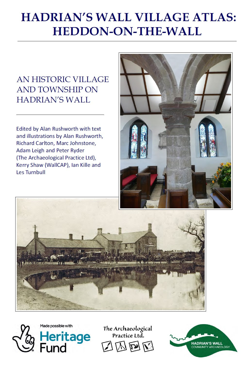
Published 2022. Edited by Alan Rushworth with text and illustrations by Alan Rushworth, Richard Carlton, Marc Johnstone, Adam Leigh and Peter Ryder (The Archaeological Practice Ltd), Kerry Shaw (WallCAP), Ian Kille and Les Turnbull. A pdf copy of the Atlas can be downloaded from this website at the following link.
Note: the download pdf (6MB) provided is a heavily compressed version of the original file (253MB). The result is much degraded reproduction of figures and photographs. I will provide a link to download larger versions when that becomes available elsewhere online. 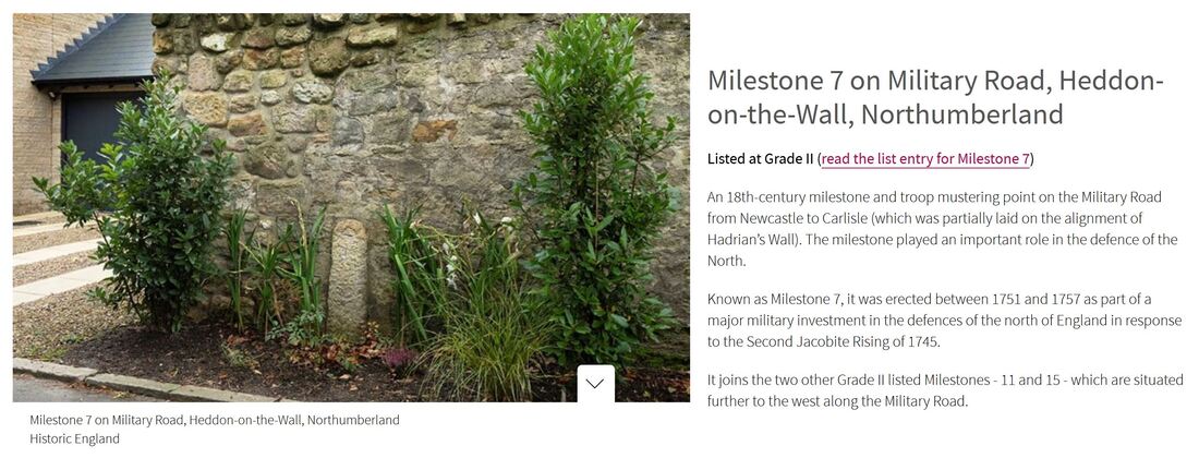 Historic England Highlights Fascinating Heritage Sites Listed in 2022 (Published 15 December 2022). . 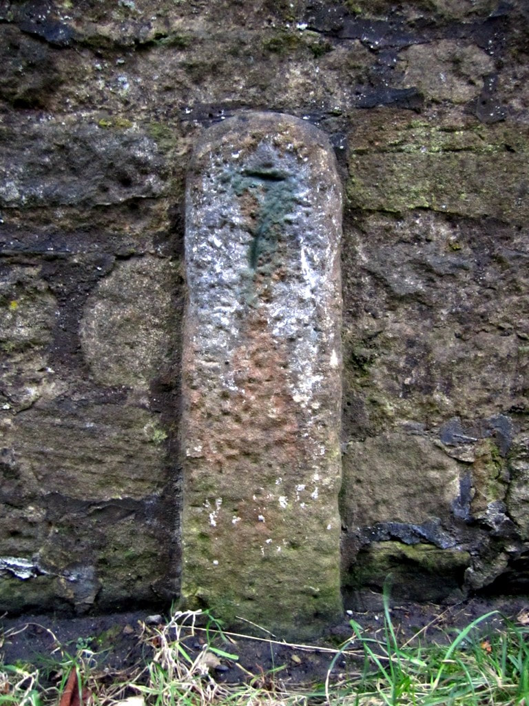 Milestone 7 by Old Military Road, Heddon on the Wall. Photo A Curtis (2011). 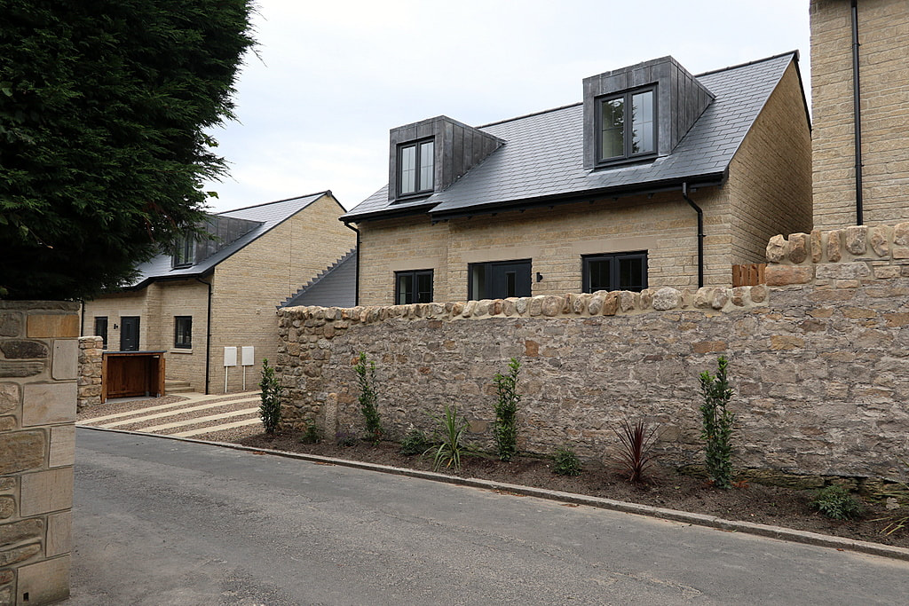 Location of Milestone 7 by wall of Tulip Mews. Photo A Curtis (2020). Historic England List Entry 1483329 Grade II Listed on 6th December 2022 Name: Milestone 7 Location: Adjacent to the north boundary wall of Thornlea Cottage, Tulip Mews, Heddon-on-the-Wall, Northumberland, NE15 0DR. Summary Military milestone, erected between mid-1751 and 1758 as part of the military road linking Newcastle to Carlisle, built in response to the second Jacobite Rising of 1745. Reasons for DesignationThis milestone erected between 1751 and 1757, is listed at Grade II for the following principal reasons: Architectural Interest A rare, well-preserved, early example of a milestone sited in its original location, its simplicity being characteristic of its C18 date and military origins; It remains fully legible and unusually it only shows distances from one direction i.e. from Newcastle-upon-Tyne. Historic interest The milestone is illustrative of a major military investment in the defences of the North of England in the mid-C18, in response to the Second Jacobite Rising of 1745. Group value It benefits from a strong functional, historical and spatial group value with the contemporary listed Grade II Milestones 11 and 15, which are situated further to the west along the Military Road. History Milestone 7 marks the distance in miles from the west gate of Newcastle upon Tyne to this point along the military road constructed between Newcastle and Carlisle from 1751 to 1757. Known as the Military Road, currently partly reused by the B6318 and the B6528, the need for it was identified by Field Marshall George Wade (1673-1748), following his failure to intercept the Jacobite army of Charles Edward Stewart (Bonnie Prince Charlie) in November 1745. Wade was at Newcastle when the Jacobites marched from Edinburgh, taking Carlisle on the 15th and moving onwards to reach Manchester by the 23rd. Meanwhile, Wade left Newcastle for Carlisle on the 16th but had been forced to halt at Hexham by poor roads and snow, returning to Newcastle by the 22nd, without ever having made contact with the Jacobites. Although the road is now often associated with him, Wade was not involved in its construction as he died in 1748. The route of the Military Road was surveyed in 1749 and was estimated to cost in the region of £22,450. Following an Act of Parliament in 1751, construction work was contracted-out to two civilian companies, who completed the road in 1757. The first 48km follows the alignment of Hadrian's Wall, with much of the stone used for hardcore being quarried from the historic structure itself, which caused considerable disquiet among antiquarians at the time. The total cost of the road was £22,680, shared by the Cumberland and Northumberland commissioners; this figure included the purchase of land, dry stone boundary walling, stone bridges, the construction of 14 tollhouses, and erection of milestones along the length of the road, in accordance with the Act of Parliament. The original milestones were all slender stone posts and as the principal garrison was housed at Newcastle, the distances marked on them were only given from Newcastle’s west gate. Milestone 7 is sited in its original position on the southern verge of a minor road that was once part of the main A69 between Newcastle and Hexham, until the village was by-passed in the 1970s, and this section of road was closed to through traffic. It is situated within the Hadrian's Wall World Heritage Site and lies within one of the scheduled areas for Hadrian's Wall. It is shown on the 1864 25-inch Ordnance Survey map (surveyed 1860) and is labelled as 'Old Milestone' on the 1897 edition, as it had been superseded by a metal milestone sited on the turnpiked road about 380m to the east on Great Hill, which shows seven miles from the centre of Newcastle. DETAILS Military milestone, erected between mid-1751 and 1758 as part of the military road linking Newcastle to Carlisle, built in response to the second Jacobite Rising of 1745. MATERIALS Sandstone. DESCRIPTION Situated on the southern verge of the Military Road, formerly part of the B6318 and at one time a section of the A69. The stone pillar stands about one metre high and has a narrow rectangular section approximately 30cm by 15cm with a chamfered rounded upper surface. The face has a roughly punched-tooled surface and is inscribed '7' , representing the distance in miles from the west gate of Newcastle upon Tyne to this point in the mid-C18. The rear of the pillar is hidden from view against a garden wall (the garden wall is excluded from the listing). SOURCES Books and journals Lawson, W, 'The Origin of the Military Road from Newcastle to Carlisle' in Archaelogica Aelianna, Vol 44, (1966), 185-207 Lawson, W, 'The Construction of the Military Road in Northumberland 1751-1757' in Archaelogica Aelianna, Vol 1, (1973), 177-193 Websites Heddon-on-the-Wall Local History Society - Military Road, accessed 15 August 2022 from http://heddonhistory.weebly.com/blog/military-road Per Lineam Valli - What is the Military Road, Mike Bishop, 2015 accessed 18 August 2022 from https://perlineamvalli.wordpress.com/2015/06/07/69-what-is-the-military-road/ 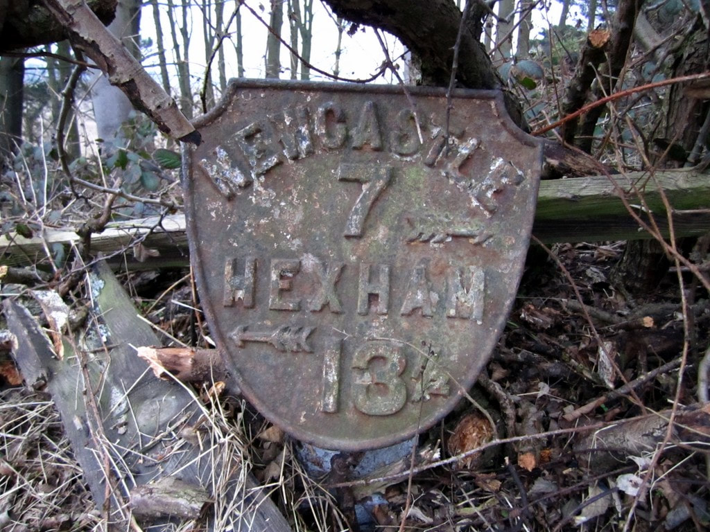 Metal shield milepost at Great Hill east of Heddon village. Photo A Curtis (2011). 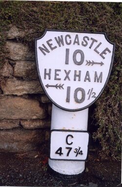 Old Milepost by the B6528, Main Street, Horsley. Photo IA Davison (2000). For those who keep their eyes open the milepost bearing the figure 8 also survives a mile west within the hedgerow alongside the road on the way to Rudchester. Those at miles 10, 11 and 12 are also recorded but none of these are listed. Milestone 16 (440m East of Portgate roundabout) and Milestone 19 (420m East of St Oswalds Hill Head Farm) were Grade II Listed in May 1988 (List Entries: 1303661 and 1042983). There are a few Grade II Listed milestones attributed to the Military Road in Cumbria but they have metal plates attached to the chamfered faces of a low stone post indicating distances to both Newcastle and Carlisle and likely date to the later 1811 turnpike. 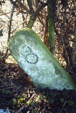 Milestone by the B6318 Military Road east of Rudchester. Photo IA Davison (2019). The village of Heddon on the Wall appears to have grown up around the location of the 12th Milecastle of Hadrian's Wall. The reasons quite why it did so, and the reasons a notable and early Saxon church (St Andrew's) was founded here are unknown (although see Ad Murum). Perhaps the rocky mound on which the church was built, standing south of Hadrian's Wall and the Vallum, was already the site of a Roman shrine. However, of this we have no evidence. Maybe the Saxon settlers who chose the spot for their village just liked the view as we do today. Milecastle 12 of Hadrian's Wall has never been definitively located although its measured location along the line of the Wall was considered to be within the enclosure west of Towne Gate. This was originally the site of Town Farm, later Tulip's Haulage Yard, and recently of the newly built development of houses known as Tulip Mews. Archaeological investigation of the Town Farm site during this development failed to locate remains of the Milecastle once the farm buildings had been demolished although did reveal limited remains of the curtain Wall itself. There are a few clues to the location of Milecastle 12:
It is possible that the cottages refered to by Bates were those of Mushroom Row. Mushroom Row consisted of two rows of houses situated just north of the modern library, south of Chare Bank, which is a footpath which partly follows the ditch of the Vallum. After demolition of the houses in 1955 the site was used by the Amos Brother's Roman Wall Forge and is now the location of a large private house, Forge House. However, as Bates mentions a "hill-top now covered with the ruins of cottages", this, and its location south of the Vallum, seem to make Mushroom Row an unlikley candidate. The cottages he refers to are more likely to have been located in the enclosure that is now occupied by Tank House due west of the enclosure that held the buildings of Town Farm and the track which runs from the old road south towards Garden House. Tank House is located on the north side of Chare Bank. The house name refers to the stone-built water tank that stood on this hilltop site. It was the village water supply from the mid C19th, fed from springs rising near East Heddon. It went out of use when a metal tank on legs was provided further south, close to the library.  Heddon water tank building before building of the modern Tank House. Photo courtesy P Sanderson. The old plans and first edition Ordnance Survey map of Heddon on the Wall shown below show the presence of buildings within the enclosure surrounding Tank House. However, only one building remains there on the 25 inch to 1 mile map of 1897, clearly named, Tank House. Graeme Stobbs (Society of Antiquaries of Newcastle upon Tyne) came to the same conclusion in a short note published in 2019 from which the following figure has been taken: Stobbs, G. (2019). Note: The probable location of Milecastle 12, Heddon-on-the-Wall. Archaeologia Aeliana, 5th series, vol. 48, pp. 167-170. 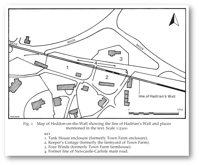 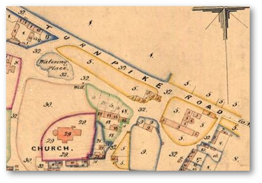 Tithe Award Map of Heddon (1848). Northumberland Archives, Ref. DT 229 M. 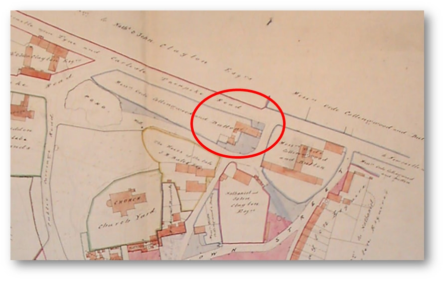 Plan of Heddon by Thomas Bell and sons (1856). Northumberland Archives, Ref. ZAN BELL 23–7. 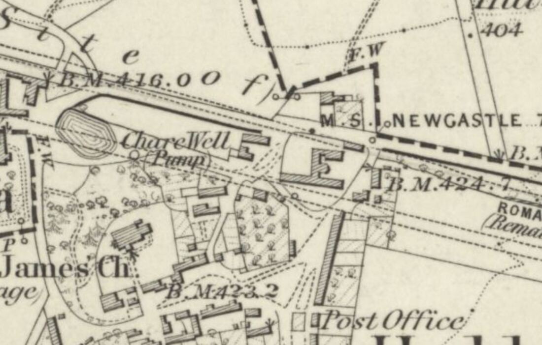 Ordnance Survey 6" to 1 mile, revised 1860, published 1865. National Library of Scotland. 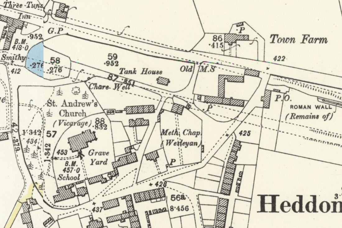 Ordnance Survey 25" to 1 mile, revised 1895, published 1897. National Library of Scotland. Plans show that Town Farm & the enclosure to its west (location of Tank House) were under the same ownership (numbered 5 on the Tithe Award Plan and named as ‘Messrs Orde, Collingwood and Dutton’ on Bell's Plan of 1856. Stobbs reasons that: The reason why Milecastle 12 was not located at the Town House farmyard in 1928 or in 2019, is that it actually sits some distance to the west, within the enclosure now known as Tank House Field (No. 1 on map). It might be objected that the eastern (Town Farm farmyard) possibility is one Roman mile from Milecastle 13, but it is well known that milecastles and turrets often lie slightly away from their measured positions for topographic reasons, and the higher ground of the Tank House enclosure may well have been preferred to the measured position. The site of the next milecastle to the east (11) is not established; measurement from its assumed position would place Milecastle 12 just to the west of the Town Farm site. Archaeological evaluation work within Tank House Field has been quite limited and there is probable potential that remains of Milecastle 12 may well survive within the enclosure, probably to the north-west of the current dwelling house. This should be considered more likely to be the milecastle site than the Town Farm location. 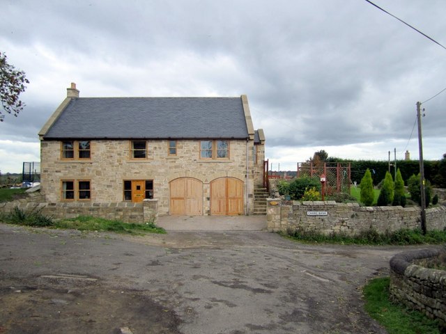 Tank House. View from the front of the house above Chare Bank. Photo A Curtis (2010). 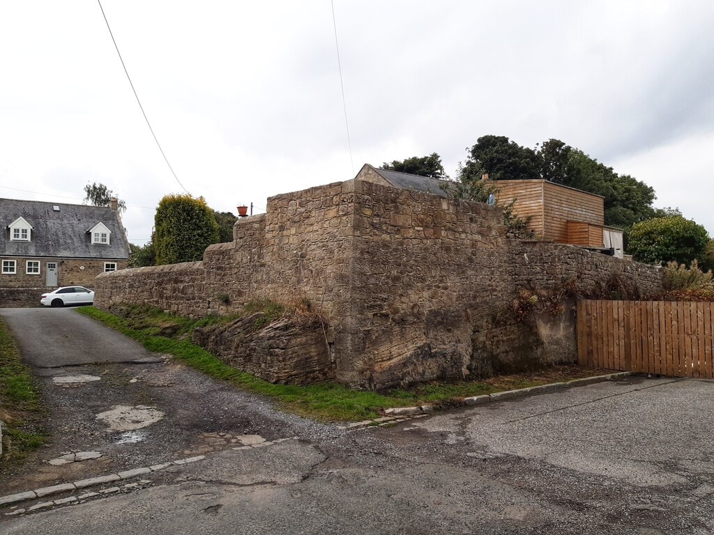 Rear wall of the back garden of Tank House above the (former) Military Road. Photo A Curtis (2022). In the photo shown above, the old road runs in the foreground of the above photo from left to right. This was the line of the Military Road (constructed in the 1750s, mainly on the foundations of Hadrian's Wall) and later the course of the A69 from Newcastle to Carlisle. The road closed when the bypass was built. The line of the Wall here lies just south of the road (the Wall perhaps had already been flattened by building within the village). The track on the left also cuts through bed-rock, runs up towards the rear of Garden House, and divides the enclosures of the original Town Farm and Tank House. This location is close to the suspected site of Milecastle 12, although it has never been found. Recent archaeology has shown it wasn't in its measured position under the buildings of Town Farm (later Tulip's Haulage Yard) slightly further east. The road was widened in 1926. At the same time, or perhaps earlier, it was cut deep into sandstone bedrock (visible below the wall) to remove an unnecessary hill. As the milecastle wasn't revealed on the line of Hadrian's Wall further east there is a high possibility that it is located somewhere on the hill in the garden above the wall, the back garden of Tank House. There were old buildings here above the road, indicated on old plans, and it might of course have been completely destroyed. 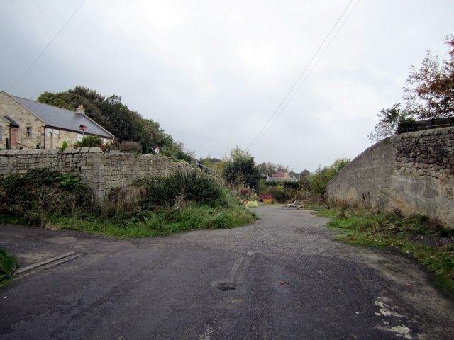 Old road near at the rear of Tank House. Photo A Curtis (2010). UPDATE January 2023 Matthew Hobson (2021) proposes a more westerly location of MC12 "somewhere between the western boundary of the current development site and the Shell garage to the west that faces onto Hexham Road. Use of Ground Penetrating Radar could perhaps be used successfully to solve this long-standing question." An archaeological watching brief at Heddon-on-the-Wall and the probable location of Milecastle 12 by Matthew S. Hobson. Archaeologia Aeliana, 5th series, vol. 50 (2021), pp. 115–132. Two phases of trenched archaeological evaluation and a watching brief were conducted by Wardell-Armstrong LLP on two nearby plots of land, formerly belonging to Town Farm, and bisected by the projected line of Hadrian’s Wall at Heddon-on-the-Wall, Northumberland. The works were deserving of particular scrutiny because the measured location of Milecastle 12, one Roman mile east of the known location of Milecastle 13, falls squarely within the development area. Indeed, a discovery of a pivot stone, probably the northern gate of the milecastle, was recorded close to the west end of an outbuilding of Town Farm in 1926. A number of later investigations at Town Farm have recorded a high degree of truncation on the site and failed to locate traces of either the milecastle or of Hadrian’s Wall. This has led to the commonly held belief that the remains of the milecastle were probably destroyed during the construction of farm buildings, or indeed earlier. The comprehensive redevelopment of the site, however, has allowed the collection of sufficient data to revisit this issue once again. Two surviving sections of the Broad Wall were recorded during the watching brief over a 20-metre stretch, proving that later truncation had not removed the entirety of the Roman archaeology on this site. The southern edge of the Wall Ditch and its upper fills were observed in the north-east of the development area and in evaluation trenches excavated along the lane to the north. The only datable finds came from a medieval kiln of unknown function, situated between Hadrian’s Wall and the Wall Ditch. The kiln is similar in form to the one still visible at the western end of the extant stretch of the Wall, 70 metres to the east. This new discovery indicates that there may have been a group of such features in this area in use from approximately the mid-13th to mid-15th century AD. With the exception of the easternmost section of the Broad Wall and the medieval kiln, all of the archaeological discoveries were made within the area of the Scheduled Monument. Each of the significant archaeological deposits, including a buried land surface preserved beneath the Wall, was sampled, but no significant archaeobotanical results were obtained. While no traces of Milecastle 12 were found, the work has led to the realisation that the discovery of 1926 was very probably made farther to the west than originally thought, where the now more accurately projected line of Hadrian’s Wall meets the former Carlisle to Newcastle main road. 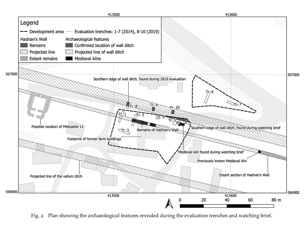 DISCUSSION: THE PROBABLE LOCATION OF MILECASTLE 12 As noted above, the measured location of Milecastle 12 falls within the development area, more or less precisely at the north-west corner of the former farm buildings. The identification of preserved remains of Hadrian’s Wall at this location, in an area which had previously been assumed to have suffered complete truncation, warrants a reassessment of the probable location of this milecastle. The 2019 investigations have confirmed that the line of the Broad Wall was positioned rather too far south to have been disturbed by the widening of the old Carlisle to Newcastle road in 1926 (referred to above). If the pivot stone discovered during the 1926 roadworks was indeed part of the in situ northern gate of Milecastle 12, the clear implication is that its location is likely to have been farther west, close to where the projected line of the curtain wall meets the remains of the old road. In our estimation the discovery of the pivot stone in 1926 is most likely to havebeen some 90m farther to the west than the measured location of the milecastle, as indicated on fig. 2. Supporting the idea that the discovery in 1926 was made farther to the west, is the fact that in 1856 the development area and the neighbouring plot of land to the west were both in possession of Messrs. Ord, Collingwood and Dutton. Stobbs (2020) has correctly observed that if these two plots of land could both be referred to as Town Farm, it would make sense of the fact that the pivot stone was described as having been found ‘close to the western end of an outbuilding of Town Farm’. The idea that the measured location of Milecastle 12 might have fallen west of the current development area, which he also refers to, cannot however be supported. The salient fact, which Stobbs does also note, is that the distance between the so called ‘milecastles’ varied depending upon the terrain and the need to communicate with forts on the Stanegate (Breeze 2006, 64–65). A discrepancy of 90m, between a measured hypothetical mile separating two adjacent milecastles and the actual distance, would be slightly more than the known average, but significantly less than the largest recorded discrepancy of more than 210m. The high level of truncation within the current development area leaves us with a high degree of uncertainty. It is still possible that the pivot stone was found during work linking up the east-west road with the north-south lane which separates these two plots of land. If any remains of the milecastle lay within the western half of the development area they are very likely to have been destroyed. The remaining uncertainty means that in future the location of the milecastle should be sought somewhere between the western boundary of the current development site and the Shell garage to the west that faces onto Hexham Road. Use of Ground Penetrating Radar could perhaps be used successfully to solve this long-standing question.
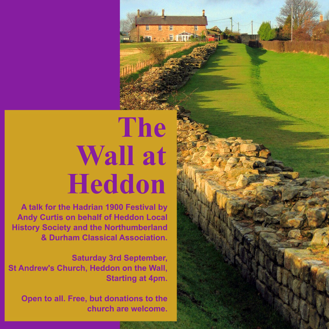
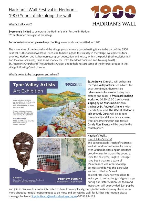
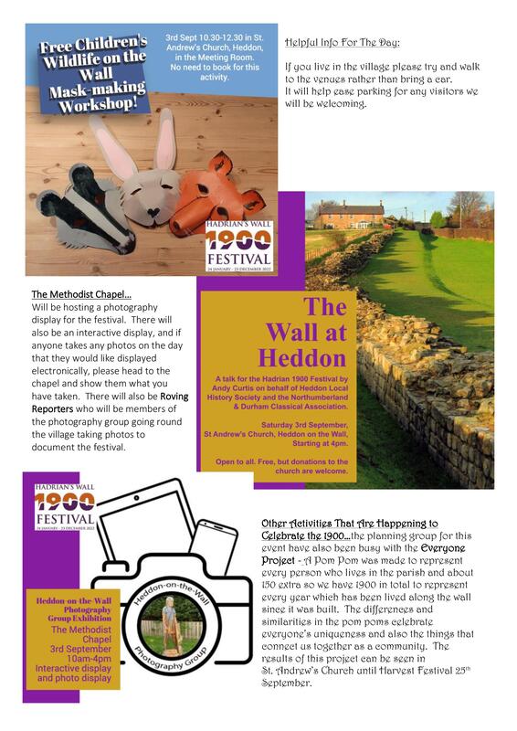
Many events at several venues around the village on Saturday 3rd September 2022.
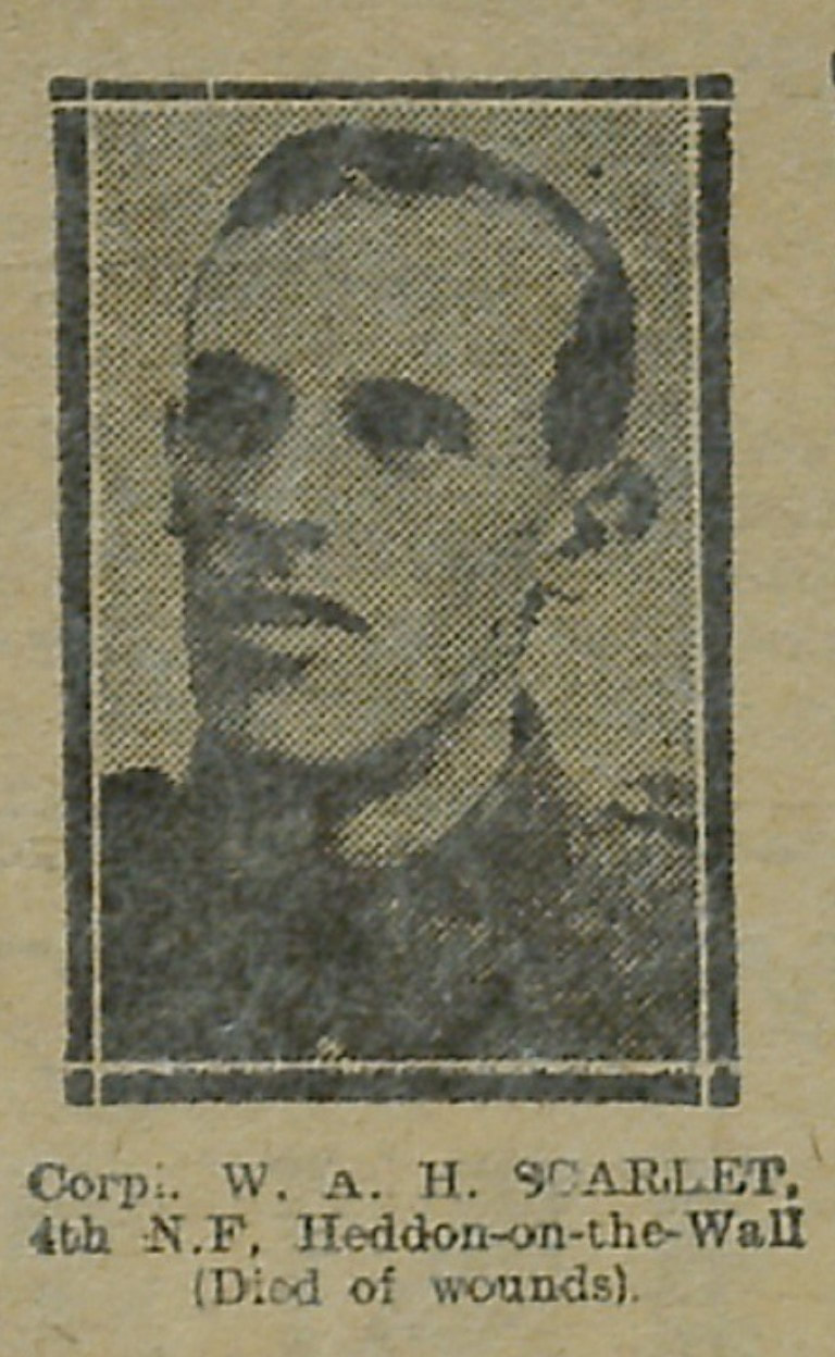
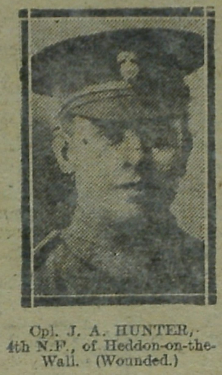
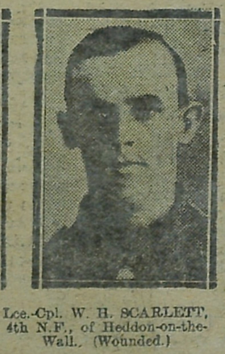
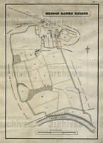
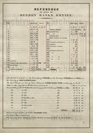
 During the First World War the Newcastle Illustrated Chronicle featured photographs of soldiers that had been sent in by relatives and friends. Here we have scanned their images to make them available online for those tracing family history or anyone with an interest in the First World War. The physical collection held by Newcastle Libraries comprises bound volumes of the newspaper from 1910 to 1925. Photos are being added as they come out of copyright. They are keen to find out more about the people in the photographs. If you recognize anyone in the images and have any stories and information to add please comment below the photo on the relevant Flickr page (see search link below). Planning application for new houses on Centurion Way and the fence erected by the developer. 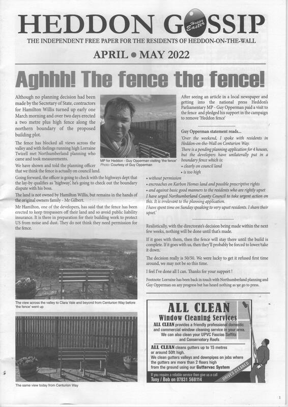 Heddon Gossip, April-May 2022.  Centurion Way - before the fence. Photo A Curtis (June 2017). 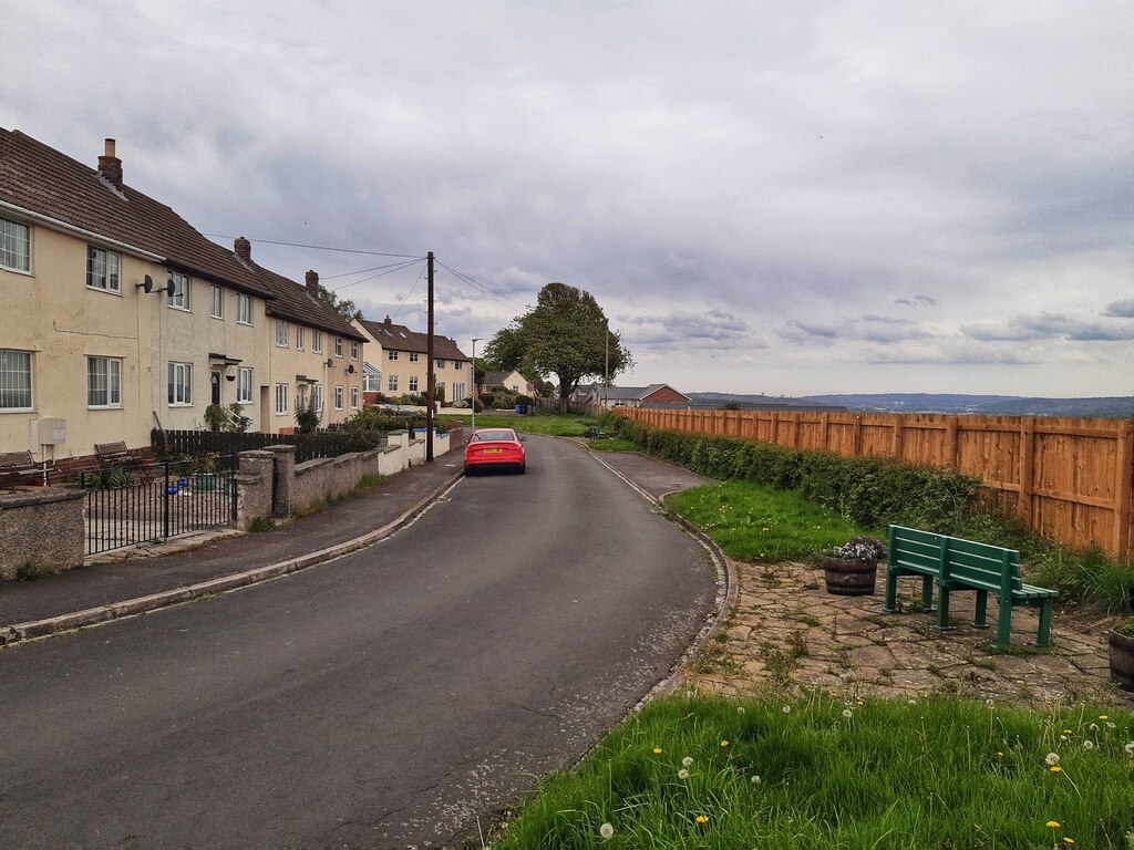 Centurion Way - after the fence. Photo A Curtis (May 2022).  Photo A Curtis (May 2022).  Killiebrigs, Heddon on the Wall. Photo A Curtis (2018). The western housing estate in Heddon on the Wall, sometimes called the Bainbridge Estate (from the builders; to differentiate it from the Vallum Estate on the east side), mainly occupies what was originally Crag(e) Field of the Heddon Banks Estate. There is a nice aerial photo of housing estate as it was being built, discussed on the blog here. I have (below) annotated parts of the two adjoined sheets (LXXXVII and XCVI) of the first edition 1:10,560 scale OS maps (1864-65) with the field-names taken from a plan of Heddon Banks Estate dated 1827 (NRO 00309/M/69). All of the streets on the new housing estate were given Roman sounding names: Trajan Walk, Remus Avenue, Aquila Drive, Campus Martius, Mithras Gardens, Taberna Close. Similar names were used on the Vallum Estate and of course for Centurion Way that connects the two. One street on the south side of the western estate was a slightly later addition and was named Killiebrigs. I often wondered where this name had come from as it is clearly not Roman and seems more Irish or Scottish. Comparison of the maps shows that this street extends through the original fields to the south of Crag Field, named on the 1827 plan as West Close and East Close. 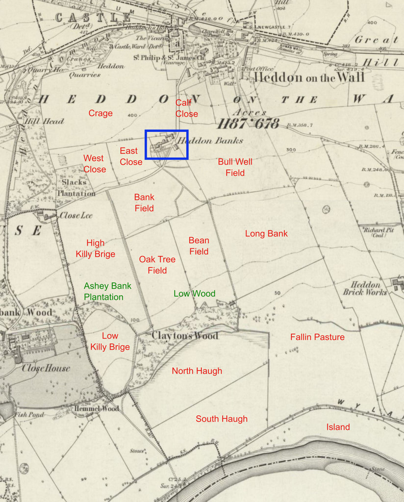 OS 1:10,560 First Edition (1864) annoted with field-names taken from 1827 plan of Heddon Banks Estate (NRO 00309/M/69) 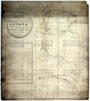 Plan of Heddon Bank estate, Heddon-on-the-Wall (1827). Northumberland Archives: NRO 00309/M/69. Click for link. 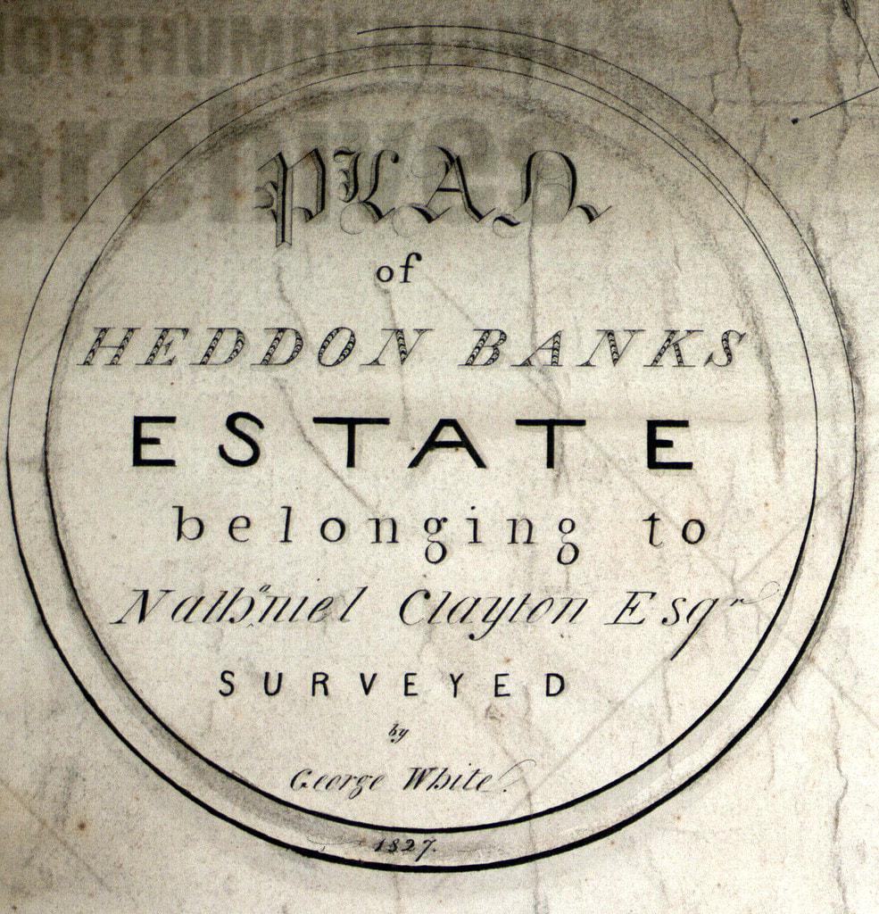 Excert from Plan of Heddon Bank estate, Heddon-on-the-Wall (1827). Northumberland Archives: NRO 00309/M/69 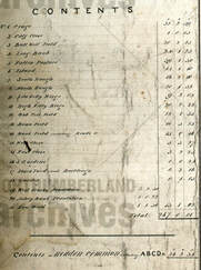 Excert from Plan of Heddon Bank estate, Heddon-on-the-Wall (1827). Northumberland Archives: NRO 00309/M/69 The Tithe Map of Heddon Banks Estate from 1849 shown below is very nicely drawn but doesn't provide the names of the fields.
We can now see where the name of the street, Killiebrigs, came from. It was derived from the names of two fields, High and Low Killy Brig(e), close to that location on the Heddon Banks Estate. What, however, could be the origin of the names given to the fields? Brig clearly indicates a bridge. There is still today a very well-built stone bridge, just east of Close Lea, close to the location of these fields. It took the course of the quarry incline under the track from Heddon Banks to Close Lea. There is a photo of the bridge here. However, the quarry in Slack Plantation was opened much later than the 1827 plan that shows the field names. The quarry and its tramway incline are indeed not present on the first edition OS map. Could there be an Irish or Scottish connection to the field-names? Killybegs (Irish: Na Cealla Beaga) is a town in County Donegal, Ireland. It is the largest fishing port on the island of Ireland. Its Irish name, Na Cealla Beaga, means 'little cells', a reference to early monastic settlements. Gaelic cill (pronounced keel) originally meant ‘cell, church’ from Old Irish cell, (ultimately from Latin cella) and now usually means ‘chapel, churchyard’ in modern Gaelic. It is found in a large number of place-names, whose widespread distribution reflects the spread of the both Gaelic language and Celtic Christianity across Scotland. It is frequently used in combination with the name of the saint to whom the church is dedicated (e.g. Kilmartin, Kilmory, Kilpatrick). Although no remains are visible now, there was a chapel just west of the field of Low Killy Brig, west of the boundary between Heddon on the Wall and Houghton & Close House townships. It stood close to the mansion of Close House: The area of Close House was probably occupied since at least the thirteenth century but the present house dates only from 1779. The name was originally thought to be Albery Close, which became corrupted as Abbey-le-Close, and gave rise to the belief that it was formerly the site of a monastic house. There was a chantry here though, first referred to in 1313, whose patron was one John Turpyn, the son of Richard Turpyn (Turpin) of Whitchester. The old chapel was pulled down in 1779 when the present mansion was built. Could there have been a bridge somewhere in the vicinity of the fields, providing access to the Close House Chantry? It seems perhaps more likely that the origin of the field-name was rather more prosaic.  NORTHUMBERLAND WORDS. A GLOSSABY OF WORDS USED IN THE COUNTY OF NORTHUMBERLAND AND ON THE TYNESIDE. BY Richard Oliver Heslop. Published for the English Dialect Society(1893-84). Volume 1 and Volume II KILLY-COUPER, an upset heels over head. Killicoup, a somerset [archaic spelling of somersault]. Killie is a plank or beam placed on a wall so that one end projects a good way further than the other. A child then places himself upon the long end, while two or three press down the short end, so as to cause him to mount."— Jamieson. John Jamieson (1759-1838), was author of the Etymological Dictionary of the Scottish Language, published in 1808, which was a landmark in the development of historical lexicography and in the study of the Scots language. Jamieson's dictionary is available online. Killie is given in the Supplement (Vol. 4; p.14). This suggests that the field-names could be just a memory of a simple plank bridge, perhaps across a ditch or small stream. Maybe one that was prone to accidental upending.
It seems a little similar in this folk-lore origin of the name of Bays Leap farm. If anyone has another theory or has more information, please let me know. The Lesson of the Water Mill by Sarah Doudney from Wikipedia Listen to the water mill Through the livelong day; How the clicking of the wheel Wears the hours away. Languidly the autumn wind Stirs the withered leaves; On the field the reapers sing Binding up the sheaves; And a proverb haunts my mind And as a spell is cast, "The mill will never grind With the water that has passed." We have no photos of the original Heddon Mill but you can still find it on old aerial photos, maps and archived plans. The corn mill was powered using water taken from the Dewley Burn and stored in a mill pond just west of the Mill buildings. The original site of the Mill was erased by open-cast coal mining and the building of the new A69 dual-carriageway. Few people notice the burn now chanelled under the slip-road where the road from Heddon passes under and joins the main road. You have to concentrate there on the sharp bend and the possibility of oncoming traffic from the narrow lane which comes down from East Heddon. Although the proverb of the opening poem is of course true, it doesn't tell the whole story. Water passing over the water-wheel at Heddon Mill joined the Dewley Burn just below the Mill and becomes available down-stream. Further east, north of Throckley, was another corn mill, Dewley Mill. Water was also taken from the Dewley Burn and led from a mill pond to the east of Burnside Farm by a long mill race in the fields now north of the A69. The Mill itself was just west of Dewley Farm. Dewley Burn passes Dewley Farm and runs south through Walbottle Dene. It waters were in use again further down to power the mills of Spencer's Steel Works in Newburn before they join the River Tyne. Much of this section is now hidden in a culvert. 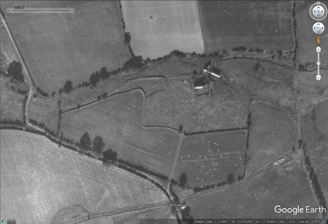 Google Earth historic imagery from 1945 aerial photos. 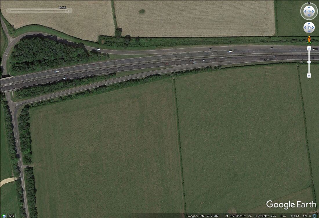 Google Earth satellite photo (2021) of same area showing former site of mill under the new A69 by-pass near Heddon turn-off. 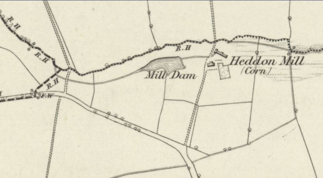 OS 1:10,560 First Edition (1865) 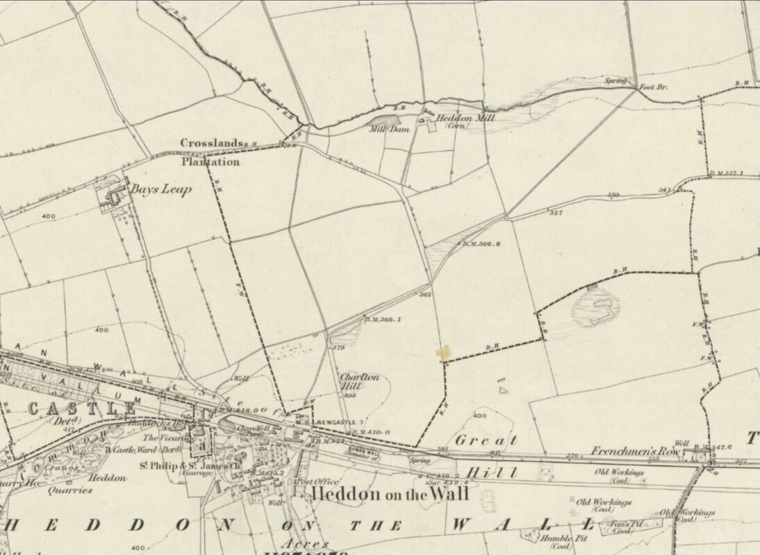 OS 1:10,560 First Edition (1865) NLS side-by-side map and aerial online link. In this mode you can drag the slider above the map windows to change from the old map to the modern satellite image. It shows the site of Heddon Mill and the old Bays Leap Farm close to the line of the new A69. Also changes in the roads leading from Heddon to Heddon Mill and Bays Leap. The original route to the Mill was from a junction on the Throckley Road near the bus shelter, over Charlton Hill (where the Bay [Horse] Leap'd) to join Mill Lane. Just along Mill Lane was another old lane connecting with the start of the current road up to East Heddon at what is now the Heddon junction on the A69. The old lanes north of the modern A69, running west via Whitchester, may have all connected up and probably predate the Military Road built on the line of Hadrian's Wall. 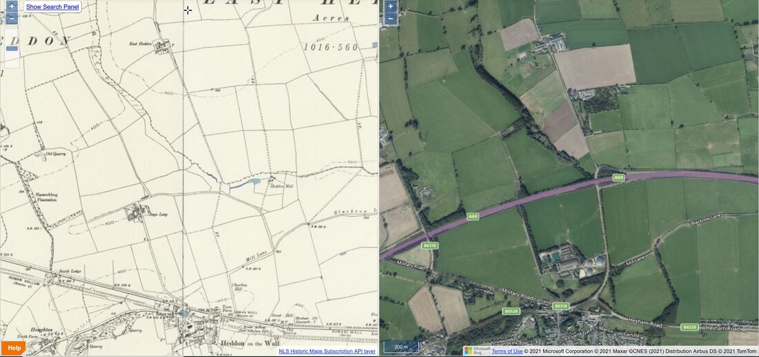 NLS Side by Side showing OS 2nd edition map 25 inches to 1 mile (1899) and Bing satellite (2021) 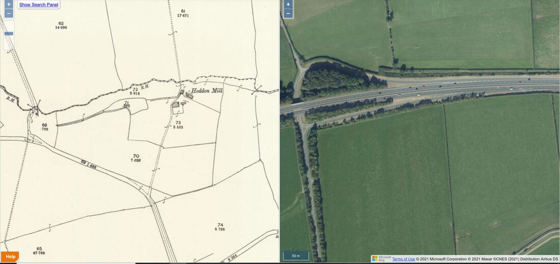 NLS Side by Side showing OS 2nd edition map 25 inches to 1 mile (1899) and Bing satellite (2021) 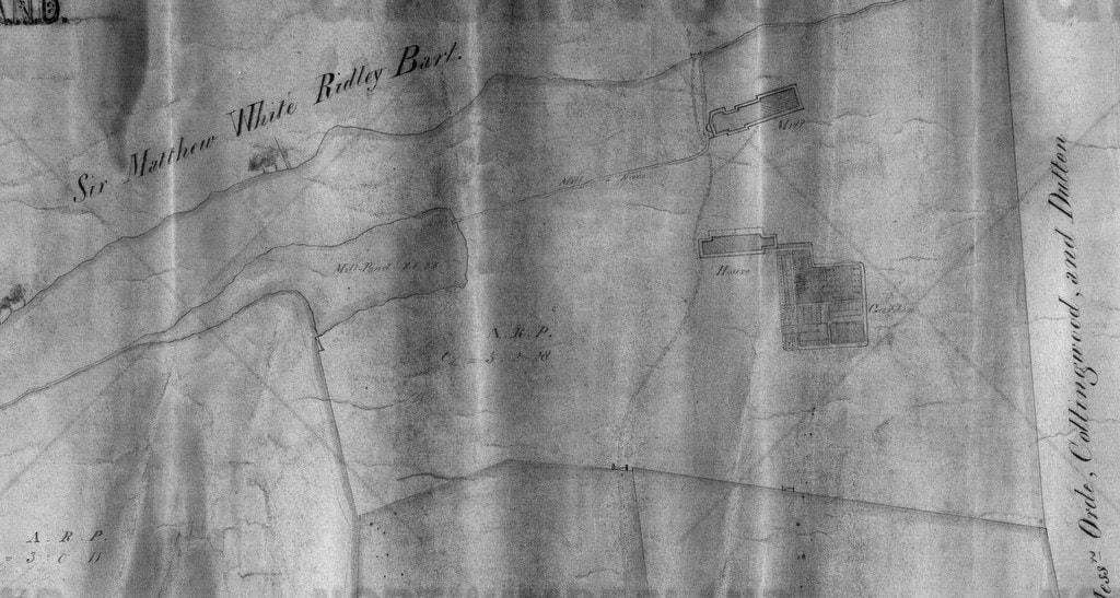 Plan of Mill Farm, Heddon on the Wall. Surveyed by J. Brion (1855). Northumberland Archives ref. NRO 00309/M/46 Plan of Mill Farm, Heddon on the Wall. Surveyed by J. Brion (1855). Northumberland Archives ref. NRO 00309/M/46 The manor of Heddon was one of the six townships which comprised an isolated portion of the Barony of Styford and bestowed by Henry I on Hugh de Bolbec during the period 1100-1135, becoming known as the Bolbec Barony. Following the death of Hugh de Bolbec, an extent (inventory) of the manor of Heddon was made: "There are in demesne 160 acres at 6d per acre, sum £4; 3 acres of meadow at 8d per acre, sum 2s; 5 bondmen each of whom holds 24 acres worth yearly 18s 2d and they hold between them 12 acres 9s 1d; of the fishery of the said manor, 5 marks; the mills are worth yearly 5 marks; 22 acres worth yearly 15s 2d for farm and works; 13 acres worth 11s 1d; 5 acres of land which a certain widow holds worth yearly 2s 6d; 14 cottages worth yearly 26s 2d; Office of the smith worth yearly 2s 0d; of the Brew-house 4s 0d; Rent in hens yearly is worth 21d; pannage is worth yearly 2s 8d; birds taken at Wydestokes yearly 2s 0d; herbage of the same close yearly 12d; sum of the sums of Heddon £18 5s 5d." The common lands of Heddon, amounting to 1,020 acres, were divided by award on 28th September 1717:
Tennants of the lands of Heddon retained the liberty to come to the Mill Dams with their cattle in a storm to fetch their water as was their usual practice. William Smith, died at Heddon Mill in 1801 aged 81. In 1828, the millwright was named as Ralph Laws. The corn miller was John Smith. William Laws succeded Ralph in 1856. In 1886, John Smith was farmer at Heddon Mill Farm. In 1918, the widow of John Clayton, grandson of Nathaniel, sold the farms of Bays Leap, Heddon Mill and Towne House to Adam and James Hedley of Newcastle. East Town Farm and several other pieces of land were sold to Sir James Knott for £13,345. In 1924, Sir James Knott sold East Town Farm to Adam and James Hedley for £2,800. A portion of East Town Farm was given over to the Ministry of Works to protect the Roman Wall as an Ancient Monument. In 1957, the heirs of the Hedleys sold Bays Leap, Town House and Heddon Mill to the National Coal Board for open-cast mining. 70 acres of land was excavated to a depth of 200 feet to extract 2.5 million tons of coal. The land was returned to farming and Bays Leap was sold to Mr. J. Moffitt in 1965. In 1959, James Hedley sold a portion of East Town Farm to Grady's the builders to build the Vallum housing estate. The property currently bearing the name, Heddon Mill, is further west of the former Mill Farm location, on the lane that leads up to Halls of Heddon close to the interestingly named, Hassockbog Plantation (old maps show a small cottage called Hassock on the old lane just opposite Heddon House). I can only assume that Heddon Mill was reinstated in this new location at the end of open-cast coal mining, as indeed was the farm of Bays Leap, also in a slighly different location from the original property, presumably taking into account the proposed line of the new by-pass. The common land at the former Heddon Mill was, however, lost forever.so please refrain from taking your cattle there in a storm to use the water now! 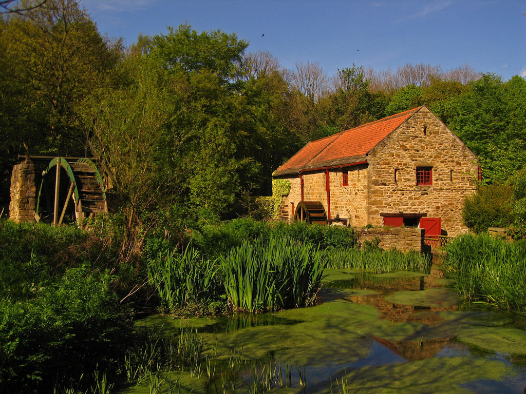 Restored working water-mill at Path Head, Summerhill, Blaydon on Tyne. The corn mill dates from 1730. Photo wfmillar (2014). Very few of England's many thousands of water-mills are still in use as heritage or working museums (although many have been converted). There is a list (probably incomplete) of those known from Northumberland here. One nearby, is that at Path Head near Blaydon which takes its water from the Blaydon Burn. It's nice to imagine that Heddon Mill might have been similar. Started in 1730 by the Townley family, the Path Head Mill worked as a corn mill until 1828. During its working life it changed owners to the Cowen family. Around 1974 the farm buildings became derelict, of which the later 1930's farmhouse is the only survivor. The area was then surrounded by extensive gravel extraction and only poultry survived. Evidence of vehicles was found during the excavations around the mill building. The mill pond was choked with fallen willow trees and these were removed to clear access to the building and the pond. The old corn stack terraces had their dry stone walls repaired and a pole barn was erected to cover some of our engineering artefacts. 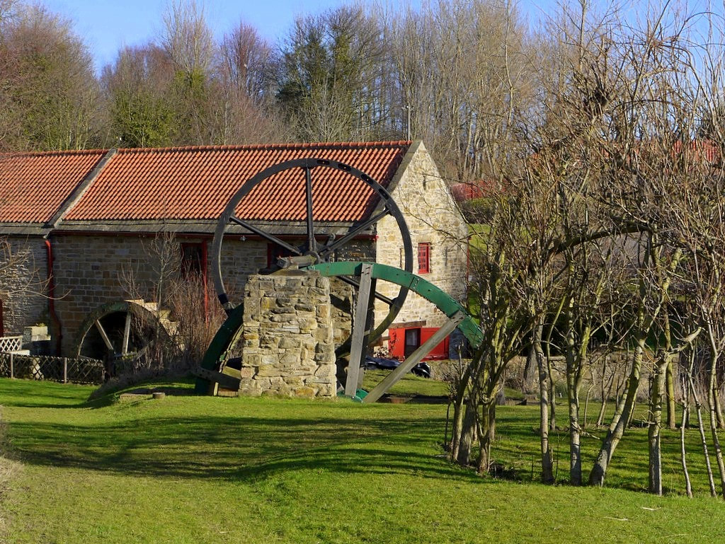 Path Head Water Mill, Blaydon. Photo by A Curtis (2012). A corn mill at Stocksfield (Ridley Mill) was first recorded in 1566 in the deserted medieval village. A mill building and waterwheel of much more recent age still survives. However, it seems unrecognised as a heritage asset unlike the nearby, Grade II listed, Ridley Mill House. 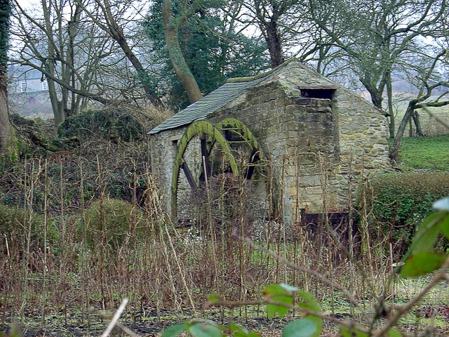 Ridley Mill near Stocksfield with its 16ft.waterwheel. Photo by Bill Cresswell (2006). 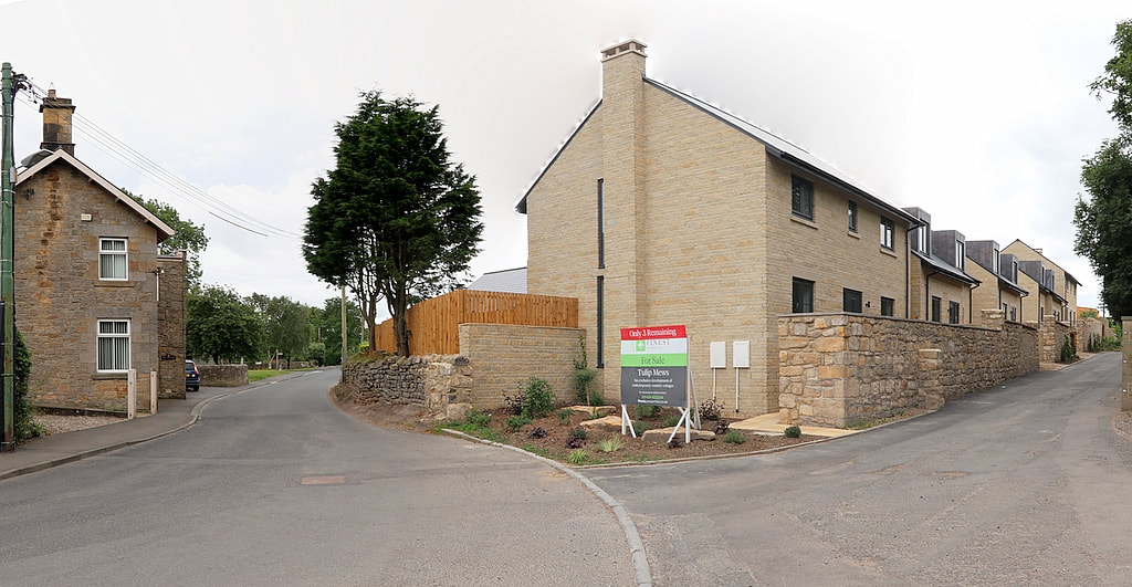 Tulip Mews from Towne Gate. Photo A Curtis (2020). Some photos of the newly built houses on the former site of Town Farm (later Tulip's Yard) adjacent to the old A69 when it passed this way through the village. The line of Hadrian's Wall likes under the houses and was subject to excavation during development of the site. The development of two detached, 4-bedroom houses and three link-detached, 3-bedroom dormer bungalows was completed in the summer of 2019. 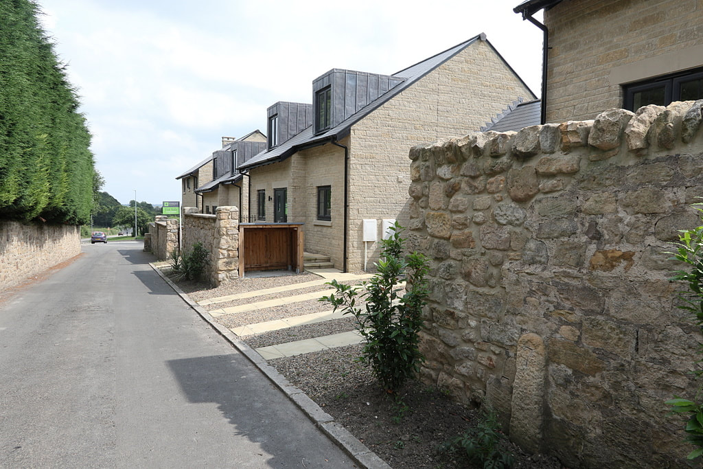 Tulip Mews, Heddon on the Wall. Photo A Curtis {2021). 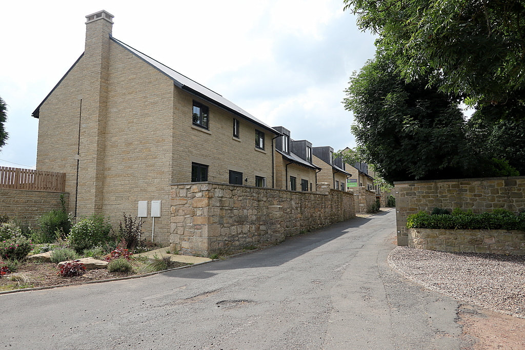 Tulip Mews, Heddon on the Wall. Photo A Curtis {2021). |
AuthorAndy Curtis Archives
April 2024
Categories
All
|
||||||


 RSS Feed
